


 WOODCHUTE MOUNTAIN TRAIL
Woodchute Wilderness Area
WOODCHUTE MOUNTAIN TRAIL
Woodchute Wilderness Area
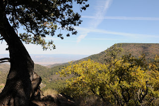
Cooler temperatures and shorter days work together to paint the oak trees on Woodchute Mountain in a palette orange and gold. The mountain is really more of a long ridgeline with Prescott Valley on one side and grand views of the red cliffs of Sedona and the peaks of Flagstaff on the other. Easy-to-follow, trail No. 102 ascends the mountain in a gently meandering style that swings from east to west showcasing vistas of much of northern Arizona. The hike culminates with an easy stroll across a breezy high prairie that dead-ends at the steep east face of the mountain. Here, blood-red maples and honey-colored scrub oaks frame views of Jerome and the Verde Valley.
LENGTH: 7.4 miles roundtrip
RATING: moderate
ELEVATION: 7,000 – 7,700 feet
GETTING THERE: From Jerome, go 7 miles southwest on Highway 89A to the turn off for Potato Patch Campground. Turn right and continue .3 mile to the signed road for the Woodchute trailhead on the left and follow it to a parking loop with restrooms. Those without a high clearance vehicle should park here. To find the trailhead, head right (east) and hike or drive (high clearance needed) up Forest Road 106 (also signed as FR 102/106) for a half-mile to the wilderness sign and trail register. If you opt to hike the road, add 1 mile to the trip length above.
INFORMATION: http://fs.fed.us/r3/prescott/recreation/trails/chino/woodchute102.shtml
NOTE: The Woodchute Fire of Aug-Sept 2009 resulted in the temporary closure of Trail102. Check with the forest service before hiking this trail.
Photos shown here are from October 2008.
For current information on fire restrictions or wildfires visit
http://www.fs.fed.us/r3/prescott or call the Prescott National Forest fire information line at 928-777-5799.


 WOODCHUTE MOUNTAIN TRAIL
Woodchute Wilderness Area
Cooler temperatures and shorter days work together to paint the oak trees on Woodchute Mountain in a palette orange and gold. The mountain is really more of a long ridgeline with Prescott Valley on one side and grand views of the red cliffs of Sedona and the peaks of Flagstaff on the other. Easy-to-follow, trail No. 102 ascends the mountain in a gently meandering style that swings from east to west showcasing vistas of much of northern Arizona. The hike culminates with an easy stroll across a breezy high prairie that dead-ends at the steep east face of the mountain. Here, blood-red maples and honey-colored scrub oaks frame views of Jerome and the Verde Valley.
LENGTH: 7.4 miles roundtrip
RATING: moderate
ELEVATION: 7,000 – 7,700 feet
GETTING THERE: From Jerome, go 7 miles southwest on Highway 89A to the turn off for Potato Patch Campground. Turn right and continue .3 mile to the signed road for the Woodchute trailhead on the left and follow it to a parking loop with restrooms. Those without a high clearance vehicle should park here. To find the trailhead, head right (east) and hike or drive (high clearance needed) up Forest Road 106 (also signed as FR 102/106) for a half-mile to the wilderness sign and trail register. If you opt to hike the road, add 1 mile to the trip length above.
INFORMATION: http://fs.fed.us/r3/prescott/recreation/trails/chino/woodchute102.shtml
NOTE: The Woodchute Fire of Aug-Sept 2009 resulted in the temporary closure of Trail102. Check with the forest service before hiking this trail. Photos shown here are from October 2008.
For current information on fire restrictions or wildfires visit http://www.fs.fed.us/r3/prescott or call the Prescott National Forest fire information line at 928-777-5799.
WOODCHUTE MOUNTAIN TRAIL
Woodchute Wilderness Area
Cooler temperatures and shorter days work together to paint the oak trees on Woodchute Mountain in a palette orange and gold. The mountain is really more of a long ridgeline with Prescott Valley on one side and grand views of the red cliffs of Sedona and the peaks of Flagstaff on the other. Easy-to-follow, trail No. 102 ascends the mountain in a gently meandering style that swings from east to west showcasing vistas of much of northern Arizona. The hike culminates with an easy stroll across a breezy high prairie that dead-ends at the steep east face of the mountain. Here, blood-red maples and honey-colored scrub oaks frame views of Jerome and the Verde Valley.
LENGTH: 7.4 miles roundtrip
RATING: moderate
ELEVATION: 7,000 – 7,700 feet
GETTING THERE: From Jerome, go 7 miles southwest on Highway 89A to the turn off for Potato Patch Campground. Turn right and continue .3 mile to the signed road for the Woodchute trailhead on the left and follow it to a parking loop with restrooms. Those without a high clearance vehicle should park here. To find the trailhead, head right (east) and hike or drive (high clearance needed) up Forest Road 106 (also signed as FR 102/106) for a half-mile to the wilderness sign and trail register. If you opt to hike the road, add 1 mile to the trip length above.
INFORMATION: http://fs.fed.us/r3/prescott/recreation/trails/chino/woodchute102.shtml
NOTE: The Woodchute Fire of Aug-Sept 2009 resulted in the temporary closure of Trail102. Check with the forest service before hiking this trail. Photos shown here are from October 2008.
For current information on fire restrictions or wildfires visit http://www.fs.fed.us/r3/prescott or call the Prescott National Forest fire information line at 928-777-5799.
No comments:
Post a Comment