

 SECOND WATER TRAIL
Superstition Wilderness
SECOND WATER TRAIL
Superstition Wilderness
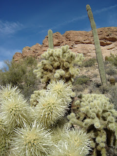
Classic desert landscapes, a sprawling valley populated with thousands of teddy bear cholla and a tiny pocket of green where spring water feeds willows and waist-high grasses are the highlights of the Second Water Trail #236. Because the trailhead is easy-to-access and the route is relatively straight forward, this trails attracts lots of visitors. The hike begins on the Dutchman Trail #104, following it for a short distance to the junction with trail #236. From the junction, turn left and follow Second Water trail through a maze of creek beds, sandy flood plains and open fields studded with cactuses and thorny shrubs. As the trail undulates through canyons and washes, views of the stark, yet beautiful landscape chiseled from volcanic landforms open up along the high points before the trail ends at the junction with the Boulder Canyon trail where there’s a tiny spring-fed riparian eco-system tucked into a reed-lined cove.
LENGTH: 6.3 miles round-trip
RATING: moderate
ELEVATION: 1,900 feet – 2,450 feet
GETTING THERE:
From Phoenix, take Highway 60 east to the Idaho Road exit (Highway 88), go left onto Highway 88 following the signs to Lost Dutchman State park. Continue to one-quarter mile past the park entrance and turn right onto First Water Road (Forest Road 78). Follow FR78 for 2.6 miles to the First Water Trailhead. FR 78 is maintained dirt with a few rough spots. There are restrooms at the trailhead.
INFORMATION:
Visit fs.fed.us/r3/tonto/recreation/rogs/hikingtrail/wilderness/Trails/superstition/ or call
(480) 610-3300


 SECOND WATER TRAIL
Superstition Wilderness
Classic desert landscapes, a sprawling valley populated with thousands of teddy bear cholla and a tiny pocket of green where spring water feeds willows and waist-high grasses are the highlights of the Second Water Trail #236. Because the trailhead is easy-to-access and the route is relatively straight forward, this trails attracts lots of visitors. The hike begins on the Dutchman Trail #104, following it for a short distance to the junction with trail #236. From the junction, turn left and follow Second Water trail through a maze of creek beds, sandy flood plains and open fields studded with cactuses and thorny shrubs. As the trail undulates through canyons and washes, views of the stark, yet beautiful landscape chiseled from volcanic landforms open up along the high points before the trail ends at the junction with the Boulder Canyon trail where there’s a tiny spring-fed riparian eco-system tucked into a reed-lined cove.
LENGTH: 6.3 miles round-trip
RATING: moderate
ELEVATION: 1,900 feet – 2,450 feet
GETTING THERE:
From Phoenix, take Highway 60 east to the Idaho Road exit (Highway 88), go left onto Highway 88 following the signs to Lost Dutchman State park. Continue to one-quarter mile past the park entrance and turn right onto First Water Road (Forest Road 78). Follow FR78 for 2.6 miles to the First Water Trailhead. FR 78 is maintained dirt with a few rough spots. There are restrooms at the trailhead.
INFORMATION:
Visit fs.fed.us/r3/tonto/recreation/rogs/hikingtrail/wilderness/Trails/superstition/ or call
(480) 610-3300
SECOND WATER TRAIL
Superstition Wilderness
Classic desert landscapes, a sprawling valley populated with thousands of teddy bear cholla and a tiny pocket of green where spring water feeds willows and waist-high grasses are the highlights of the Second Water Trail #236. Because the trailhead is easy-to-access and the route is relatively straight forward, this trails attracts lots of visitors. The hike begins on the Dutchman Trail #104, following it for a short distance to the junction with trail #236. From the junction, turn left and follow Second Water trail through a maze of creek beds, sandy flood plains and open fields studded with cactuses and thorny shrubs. As the trail undulates through canyons and washes, views of the stark, yet beautiful landscape chiseled from volcanic landforms open up along the high points before the trail ends at the junction with the Boulder Canyon trail where there’s a tiny spring-fed riparian eco-system tucked into a reed-lined cove.
LENGTH: 6.3 miles round-trip
RATING: moderate
ELEVATION: 1,900 feet – 2,450 feet
GETTING THERE:
From Phoenix, take Highway 60 east to the Idaho Road exit (Highway 88), go left onto Highway 88 following the signs to Lost Dutchman State park. Continue to one-quarter mile past the park entrance and turn right onto First Water Road (Forest Road 78). Follow FR78 for 2.6 miles to the First Water Trailhead. FR 78 is maintained dirt with a few rough spots. There are restrooms at the trailhead.
INFORMATION:
Visit fs.fed.us/r3/tonto/recreation/rogs/hikingtrail/wilderness/Trails/superstition/ or call
(480) 610-3300
No comments:
Post a Comment