


 MURRAY BASIN: FLAT TOP MOUNTAIN
Apache-Sitgreaves National Forest
MURRAY BASIN: FLAT TOP MOUNTAIN
Apache-Sitgreaves National Forest
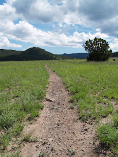
Whether you’re a weekend warrior, seasoned power-hiker, mountain biker or an equestrian, the trail system of Murray Basin has got you covered. More than 18-miles of shared-use trails criss-cross the emerald green pinion-and-juniper-studded grasslands in the foothills of the White Mountains. Each of the 10 well-defined trails in the basin is unique –it would take several days to explore all that this scenic area has to offer. Easy options include trails that lead to an old cemetery, cabin ruins and interpretive signs that describe the history of the basin. A more challenging route climbs to the top of Flat Top Mountain (8,120 feet) for great views of the Springerville volcanic field and Mount Baldy Wilderness. Although the Flat Top Mountain hike is a good introduction to Murray Basin it’s helpful to pick up a detailed map of the area at the Springerville ranger station to learn how to access the entire trail network.
LENGTH: 3 miles round-trip
RATING: moderate
ELEVATION: 7,220 – 8,120 feet
GETTING THERE:
From downtown Eagar, go left (east) on Highway 260/180 and continue 3.4 miles to the turnoff for the trailhead on the right between mileposts 403 and 404.
The Flat Top Mountain route: start hiking on the obvious main trail -- keeping left at the unsigned junctions and follow the signs to the top of the ridge.
INFORMATION: Springerville ranger station: www.fs.fed.us/r3/asnf (928) 333-4372


 MURRAY BASIN: FLAT TOP MOUNTAIN
Apache-Sitgreaves National Forest
Whether you’re a weekend warrior, seasoned power-hiker, mountain biker or an equestrian, the trail system of Murray Basin has got you covered. More than 18-miles of shared-use trails criss-cross the emerald green pinion-and-juniper-studded grasslands in the foothills of the White Mountains. Each of the 10 well-defined trails in the basin is unique –it would take several days to explore all that this scenic area has to offer. Easy options include trails that lead to an old cemetery, cabin ruins and interpretive signs that describe the history of the basin. A more challenging route climbs to the top of Flat Top Mountain (8,120 feet) for great views of the Springerville volcanic field and Mount Baldy Wilderness. Although the Flat Top Mountain hike is a good introduction to Murray Basin it’s helpful to pick up a detailed map of the area at the Springerville ranger station to learn how to access the entire trail network.
LENGTH: 3 miles round-trip
RATING: moderate
ELEVATION: 7,220 – 8,120 feet
GETTING THERE:
From downtown Eagar, go left (east) on Highway 260/180 and continue 3.4 miles to the turnoff for the trailhead on the right between mileposts 403 and 404.
The Flat Top Mountain route: start hiking on the obvious main trail -- keeping left at the unsigned junctions and follow the signs to the top of the ridge.
INFORMATION: Springerville ranger station: www.fs.fed.us/r3/asnf (928) 333-4372
MURRAY BASIN: FLAT TOP MOUNTAIN
Apache-Sitgreaves National Forest
Whether you’re a weekend warrior, seasoned power-hiker, mountain biker or an equestrian, the trail system of Murray Basin has got you covered. More than 18-miles of shared-use trails criss-cross the emerald green pinion-and-juniper-studded grasslands in the foothills of the White Mountains. Each of the 10 well-defined trails in the basin is unique –it would take several days to explore all that this scenic area has to offer. Easy options include trails that lead to an old cemetery, cabin ruins and interpretive signs that describe the history of the basin. A more challenging route climbs to the top of Flat Top Mountain (8,120 feet) for great views of the Springerville volcanic field and Mount Baldy Wilderness. Although the Flat Top Mountain hike is a good introduction to Murray Basin it’s helpful to pick up a detailed map of the area at the Springerville ranger station to learn how to access the entire trail network.
LENGTH: 3 miles round-trip
RATING: moderate
ELEVATION: 7,220 – 8,120 feet
GETTING THERE:
From downtown Eagar, go left (east) on Highway 260/180 and continue 3.4 miles to the turnoff for the trailhead on the right between mileposts 403 and 404.
The Flat Top Mountain route: start hiking on the obvious main trail -- keeping left at the unsigned junctions and follow the signs to the top of the ridge.
INFORMATION: Springerville ranger station: www.fs.fed.us/r3/asnf (928) 333-4372
No comments:
Post a Comment