Find A Trail. Start Your Search Here:

Monday, August 1, 2022

Snake-Anaconda-AZ Cypress Loop

SNAKE-ANACONDA-AZ CYPRESS LOOP

High desert vegetation on the Anaconda Trail

If there’s such a thing as an underside of Sedona’s trail systems, it must be where the snakes are.

A velvet ash tree shades a crossing of Dry Creek

Reptilian only in their stealth and serpentine courses, the Anaconda and Snake trails are

tucked into the core of the Upper Dry Creek Area Trails which is about as close as one can get to an underside in Red Rock Country.

Agave are plentiful on the Anaconda trail

 
The two short singletracks serve as customizable legs for various linear and loop hike options in a hilly parcel of Coconino National Forest not far from the juggernauts of Bear Mountain, Devil’s Bridge and Boynton Canyon.
Juniper and prickly pear cacti on the Snake Trail

The trail duo is best accessed from the isolated AZ Cypress trailhead that sits like an ignored middle child about a mile north of the congested Dry Creek Vista trailhead on Dry Creek Road.

Beehive cactus on the Anaconda Trail

View of Red Rock Secret Mountain Wilderness

One way to try these twisting paths is to tie in with the AZ Cypress trail for a moderate-rated, 3.3-mile trek.
Mescal Mountain (center, red) seen from hike high points

The benefits of hiking in this woodsy pocket begin at the roomy trailhead that’s usually free of parking quagmires.  The circuit starts with a 0.1-mile hike to the AZ Cypress/Snake junction. 
Trails are well signed

The route is well signed throughout with directional and map signage. The half-mile Snake trail marks the beginning of a mild 650-foot climb up the east flanks of a knoll above the Dry Creek drainage area. 
Doe Mountain (left) and Bear Mountain

Willows at a crossing of Dry Creek

Gradually, fantastic views of Mescal Mountain and the colorful rock formations of Red Rock Secret Mountain Wilderness peek out over a sea of junipers, fir and cypress trees. The edgy route bends to the south, exposing views of iconic Lizardhead, Chimney Rock and Courthouse Butte before connecting with the Anaconda trail. 
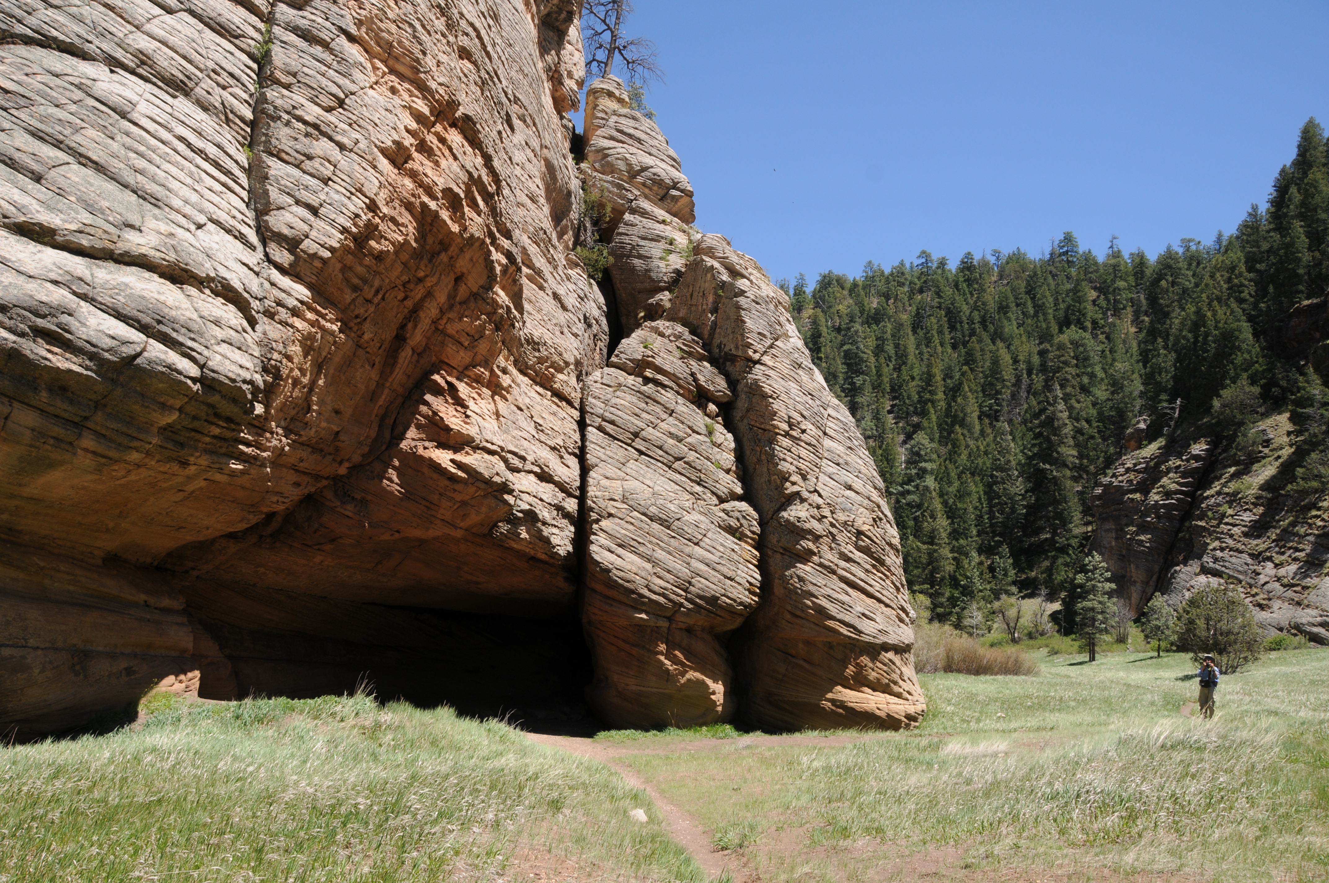
Shady passage of AZ Cypress Trail along Dry Creek

Over its 1.7-mile length, Anaconda lives up to its name with relentless kinks, bends and sinuous curls that land hikers at the loop’s highest points overlooking the Cockscomb formation, Doe Mountain, Bear Mountain and the distant double mesas of Wilson Mountain to the northeast. The hike’s apex territory is dominated by classic high desert vegetation. Cacti, manzanita, yucca, agave and a smattering of mesquite trees thrive among scrub oak and junipers. 
Most of the climbing happens on the Snake Trail

Heading due west, Anaconda trail stairsteps down red earth ledges to meet the AZ Cypress trail, the final leg of the hike, at the edge of Dry Creek. 
Yellow menodora bloom April - September

Now in a moister microclimate, the environment shifts from sunny and spiny to shady and succulent.  Tracing the creek for its entire 1-mile length, AZ Cypress trail is like a green tunnel replete with massive tree cover with water loving species like willows, velvet ash and sycamores tossed in for variety.
Mountain lion? Measured about 5" high.

The narrow path clings to shelves above the ephemeral waterway which flows after rains and during snowmelt season.  While this Eden-like scene undoubtedly includes actual snakes, encounters are rare. Like anywhere in Arizona, hikers probably walk by a few snakes on every trail, oblivious to their presence. Preferring to hide in brush and under rocks during the day, snakes value their peace and quiet--not unlike hikers who gravitate to places like this.
Cockscomb formation seen from Anaconda Trail

LENGTH: 3.3-mile loop

RATING: moderate

ELEVATION: 4,329 – 4,678 feet

GETTING THERE:

From the State Route 179/89A traffic circle in Uptown Sedona, go 3.2 miles west (toward Cottonwood) on SR 89A to Dry Creek Road. Follow Dry Creek Road 2.7 miles to the turnoff for Forest Road 9589 (not signed) on the left. This hidden turnoff is located a few yards south of the Boynton Pass Road/Long Canyon Road “T” intersection.

Continue 0.2-mile on FR 9589 (good dirt with a few potholes) to the end and the parking circle at the AZ Cypress trailhead. 

INFO:

Coconino National Forest
https://www.fs.usda.gov/recarea/coconino/recreation/hiking/recarea/?recid=71954&actid=50

Monday, July 25, 2022

Picture Canyon Natural and Cultural Preserve

PICTURE CANYON NATURAL and CULTURAL PRESERVE

Bridge over the Rio de Flag

On the industrial side of the tracks a few miles east of Downtown Flagstaff, a tiny preserve set between the unglamourous footprints of a wastewater plant and public works facility interrupts the churn of municipal infrastructure with a surprising corridor of green.

Deep water pond near wastewater treatment plant

Mt. Elden (left) and Sheep Hill cindercone viewed from the trails

Picture Canyon Natural and Culture Preserve protects a swath of rare habitats and human history huddled around a perennially moist branch of the Rio de Flag watershed, a natural stream system with headwaters at the base of the San Francisco Peaks and Mount Elden that flows in ephemeral tendrils through Flagstaff.

Slimleaf lima bean blooms May - October

Mountain tansy mustard bloom July - August

Named for panels of petroglyphs (rock art) etched into stone along one of the site’s three trails, the 478-acre parcel protects sensitive terrain, Native American heritage sites and wildlife habitats.

Along with a 1.2-mile section of the 800+-mile Arizona National Scenic Trail that bisects it, the preserve’s Tom Moody and Don Weaver trails provide easy walking tours that tie in visits to a deep-water pond, historic railroad trestle, waterfall, pithouse, petroglyphs and a crossing of the Rio de Flag waterway by way of a wooden bridge. For longer hikes, the trails also connect with the 44-mile, city-circling Flagstaff Loop Trail.

Pine-oak woodlands: one of several eco zones in the preserve

Preserve trails link with the AZT and Flagstaff Loop


The compact preserve on the drier, leeward (a.k.a. “rain shadow”) side of San Francisco Mountain packs in an amazing snapshot of Northern Arizona’s biodiversity in an ordinarily semi-arid environment.

Signs at the petroglyph site detail their significance

Buffalo gourds bloom May-Aug along the Rio de Flag

Basalt canyons, slopes and a variety of soil types create niches that foster myriad microclimate zones including meadows, pine forests, floodplains, and riparian corridors rife with willow and reeds.

A perennially flowing segment of the Rio de Flag

The preserve also serves native wildlife by providing a contiguous land bridge that allows elk, deer, and other animals to circumvent urban areas and safely cross between grasslands, forests, and wetlands.

Colorful layers of Sheep Hill cindercone

Prairie coneflower bloom Jun-Oct

Tom Moody trail traces the Rio de Flag floodplain

Listed on the National Register of Historic Places and designated as both a Northern Arizona Audubon Bird Sanctuary and an Arizona Game & Fish Department Arizona Watchable Wildlife Experience site, preserve visitors may spot waterfowl, large mammals, raccoons and more than 200 species of year-round and migratory birds.

Rock art panels decorate basalt cliffs

A map kiosk and brochures available at the trailhead give information about the site’s archeology, wildlife, and history to enrich the hike through this living sanctuary and outdoor classroom.

A waterfall trickles through a basalt canyon

LENGTH:

Tom Moody Trail: 3.9-mile circumference loop

Don Weaver Trail: 0.7-mile

Arizona Trail: 1.2 miles

RATING: easy

ELEVATION: 6,587 – 6,849 feet

GETTING THERE:

From Downtown Flagstaff, go 4 miles east on Historic Route 66, turn left on El Paso Flagstaff Road and continue 1 mile to the trailhead on the right.

INFO:

https://www.flagstaff.az.gov/2881/Picture-Canyon-Natural-Cultural-Preserve

Monday, July 18, 2022

Arizona Trail: Passage 31

ARIZONA NATIONAL SCENIC TRAIL: WALNUT CANYON PASSAGE 31

Gate on Passage 31 of the Arizona Trail

Shady and cool, Passage 31 of the Arizona National Scenic Trail is a satisfying respite from summer heat.  The 17.9-mile segment of the 800+-mile, state traversing route

drops off the plateau lakes region of Anderson Mesa and heads into pine-oak woodlands in Coconino National Forest southeast of Flagstaff.  Also known as the Walnut Canyon passage for its swing by the finger canyons and periphery of Walnut Canyon National Monument, this close-to-town segment of trail has several access points that make it perfect for day hikes, loop and car shuttle options. One trip to try goes from Marshall Lake to Sandy’s Canyon.

Greenery around Marshall Lake Tank

At the Marshall Lake trailhead, hikers get a reality check on the effects of drought.  While Marshall Lake is rarely more than a shallow, reed-choaked pond, this year, it’s bone dry.  Still, its elongated, pine-wrapped footprint is a picturesque sight and favorite grazing territory for elk.

Mountain vistas are meager, trees are major

The hike heads north from the large Arizona Trail sign along a well-defined and maintained singletrack.

Sign at Marshall Lake trailhead

 
Thick tree coverage and riffled terrain obscure big vistas, so this hike is more about immersing in the details of forest life. 
There are many ways to extend this Flagstaff hike

It’s a great place to smell “yellow belly” pines--older Ponderosa pine trees that have developed yellow-brown bark scales and emit a syrupy fragrance that’s often described as butterscotch, vanilla or cardamon. 
Marshall Lake was dry, July 2022

Each tree has a unique olfactory signature that blooms when warmed by the sun. 
Winged buckwheat blooms July - September

Go ahead and take a whiff, but be respectful. There’s no need to damage the bark to determine if the sap is sweet, savory or spicy.  
Hike may be extended into Sandy's Canyon


About 1.5 miles in, the green swale behind Marshall Mesa Tank appears below a set of easy switchbacks that lead into a shallow ravine.  The wildlife water hole is contained by an earthen dam, but, like the lake, it was dry, but lingering moisture feeds a fringe of wildflowers and elderberry trees.

Limestone formations in Sandy's Canyon

Several more minor downhill twists lead to the junction with the Sandy’s Canyon trail. 

Yellow belly pines add olfactory notes to the hike

Here, the Arizona Trail veers right into the canyon where bizarre limestone formations are the key attractions on this very popular forest destination. For those who parked a shuttle vehicle at the Sandy’s Canyon trailhead, veer left at the junction and hike 1.5 miles for a 5.6 mile one-way trek.
Horned lizards are easy to spot on the ArizonaTrail

For a longer hike, Passage 31 continues north to Interstate 40 where it connects with the Elden Mountain Passage on the east side of Flagstaff. The trail also links up with the Flagstaff Urban Trails System and the Flagstaff Loop trail. Consult the Flagstaff city website for details on how to customize a hike circuit. Otherwise, just shit into reverse at the junction for an 8.2-mile out-and-back day hike.

LENGTH:

• 8.2 miles round trip, Marshall Lake trailhead to Sandy's Canyon junction and back.

• 17.9  miles one way for the entire segment.

• 5.6 miles one way for car shuttle.

RATING: moderate

ELEVATION: 6,885 – 7,185 feet as described here (6,500 – 7,185 feet for full passage)

GETTING THERE:

Marshall Lake trailhead:

From Flagstaff go 9 miles south on Lake Mary Road (County Road 3) to Forest Road 128 on the left, signed for Marshall Lake. Continue 2.2 miles on FR 128 (pass the observatory) to the Arizona Trail post at FR 128D, turn left and continue to the parking turnout at the large Arizona Trail sign.

Sandy’s Canyon trailhead:

From Flagstaff,  go 4.5 miles south on Lake Mary Road to the Sandys Canyon Trailhead on the left. Follow Sandy’s Canyon trail 1.5 miles to the Arizona Trail junction on the right.

INFO & MAPS:

Arizona Trail Association

Aztrail.org

Flagstaff Urban Trails System

https://www.flagstaff.az.gov/1379/Flagstaff-Urban-Trails-System-FUTS


Monday, July 11, 2022

Bill Back Park

BILL BACK PARK

Sunny meadow of Bill Back Park

No crowds, no water, no restrooms, no trash service, no picnic tables, no fees--no problem. That’s the deal with dispersed camping, a way of lodging in the forest outside of developed campgrounds.
Golden-beard penstemon bloom June - October

Camping styles at these no-frills dirt pullouts range from primitive bivouacs, group tent cities (Barbie forts, anybody?) to luxury RV setups complete with full kitchens and satellite television. Which kind of makes you wonder, no?

Forest Road 230 serves as the trail

Whatever the interpretation of “sleeping rough”, dispersed camping requires a higher degree of preparedness as well as attention to proper sanitary procedures, trash removal and campfire safety including knowing when fires are banned. 

A tiny waterhole attracts wildlife

Summertime in Arizona means forest roads are lined with pop-up temporary living quarters.  

While many of these no-star waystations are located steps away from popular hiking trails like the Arizona National Scenic Trail, others are not.

Alfalfa blooms April - October

So in between dipping into the beer cooler and flipping through tawdry novels, a good way to break up the time on the off-the-beaten track tracks is to take a walk on dirt roads to soak in the beauty of the forest and spy the details that are easy to miss while lurching along in a motor vehicle.
Woodland pinedrops bloom June- Sept

The Coconino National Forest Motor Vehicle Use Map, which is available for free in hard copy, downloadable pdf or digital format, shows where dispersed camping is allowed. 

Lupine is a common summer bloomer

No-frills dispersed campsites offer solitude

One shady, high elevation place to try is the roads around Bill Back Park south of Flagstaff and Mormon Lake.
Delicate American vetch bloom May - Sept

Less than a half-mile from paved Lake Mary Road, Forest Road 230 not only offers dozens of generously spaced campsites, but also makes for easy summer strolling under tall pines. Beginning at the junction of Stoneman Lake Road (FR213) the hike down FR 230 begins in sunny meadows before ducking into Ponderosa pine woodlands. The outwardly monodominant forest of soaring conifers belies a much richer ecological diversity that’s easily exposed to those with an inclination for discovery.

Rustic corral along a side road

Roadside pops of color, courtesy of lupine, penstemons, clover, thistle and blooming shrubs, brighten meadows while tiny waterholes harbor mini wetland environs rife with water buttercups, frogs and elk.
Yellow sweet clover blooms June- August

 
Bill Back Park, a long, open pasture fringed with pines attracts swarms of birds and critters.  At the south end of the park, Forest Road 230G spins off to the left. 
Common silverweed grows in moist areas May - August

A few yards down this non-motorized spur path, a wood-and-barbed wire corral falls apart in plain view.  Beyond the corral, the road descends through the heavily forested divide between 7,743-foot Bill Back Butte and 7,639-foot Jackson Butte.
Western Blue Flax blooms April - September

FR230 passes between Bill Back and Jackson buttes

Gamble oaks and wild roses enter the botanical mix before the road meets a cattle guard at the 3.85-mile point.
Horned spurge shrubs bloom April - August

 
 This makes for a good turnaround point in order to get back to camp for a frosty IPA in isolated, pine-swaddled bliss.  

LENGTH: 7.7 miles roundtrip

RATING: easy

ELEVATION:  7,231 – 7,406 feet

GETTING THERE:

From Flagstaff, go 34.2 miles south on Lake Mary Road (Country Road 3) to Stoneman Lake Road (Forest Road 213). Turn left and continue 0.4 mile to Forest Road 230 on the left.  Park in any of the dirt turnoffs along the road.

Coconino National Forest Motor Vehicle Use Map

https://www.fs.usda.gov/detail/coconino/landmanagement/projects/?cid=stelprdb5356224