SPECKLED
RATTLER-CRANKSET-RIDGELINE CIRCUITView from the Ridgeline Trail
Summer
hiking is Arizona is an endeavor that takes extra effort. While making long drives to the high country to
escape the Valley heat is an ideal solution, road trips to pine-shaded hiking
trails are not always feasible. View of Golden Cliffs Trail from MUP-A
But hikers
got to hike. By applying a large dose of
common sense and doubling down on safety precautions, summer hiking in the
desert is doable. Trails are well-marked in Paloma Regional Preserve
Of the many safeguards
needed to stay alive in summer heat, three are of paramount importance: timing, sun protection and, water, water, water. First, plan to hit the trails early and be
done by 8 a.m. or before the dangerous heat kicks in. Ridgeline spur to overlook
Many local parks and preserve open at sunrise,
so plan accordingly. One of the most misunderstood
elements of desert hiking involves proper attire. Knoll with spur trail overlooking the park
An investment in a brimmed hat, long sleeve
shirts and long pants made of sun-protective technical fabrics will pay off big
time. These fabrics not only shield
against sunburn and insects, but they also act like evaporative coolers to keep
moisture on your skin. Yup, you’ll feel cooler in long sleeves than a tank top.
Then there’s water. Paloma Community Park from Ridgeline trail
Bring plenty, more than you think you’ll need. I personally
carry nearly a gallon for a 3-hour desert hike.
This includes two 16-ounce bottles that I almost always end up giving
away to heat stressed hikers. Dogs will get my extra water first. Speckled Rattler Trail junction
And, speaking of dogs—leave then at home. Heat
is brutal on canines. Our furry friends suffer burnt paws, heat exhaustion and
even death on local trails every year. Saguaros on the Ridgeline Trail
With the objective
of being up-and-out by 8 a.m., hikers can maximize the effort by choosing trails
with easy access, some moderate challenge, bail out options and fantastic
views. The trails of the Paloma Regional
Preserve in Peoria exceed these criteria. A good early morning summer circuit uses the
Multi-Use Path-A, Speckled Rattler, Crankset and Ridgeline trails. Tight bend on Ridgeline Trail
From the trailhead, the route follows MUP-A
for 0.4-mile to Speckled Rattler and then connects to Crankset. This first
1.57-mile leg is flat, tracing the base of West Wing Mountain with the cut of
the Golden Cliffs trail visible on the slopes.
Valley vistas from Ridgeline Trail
A large map kiosk marks the junction with the Ridgeline trail, where the
route begins its climb. At the top of the
first of several sets of switchbacks, the trail splits. The left arm heads up a craggy knoll for a
short trek to an overlook above Paloma Community Park, a nice little diversion.Green corridor of New River below Ridgeline
View from Ridgeline overlook spur
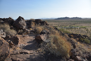
The route then traverses a saguaro dotted
ridge, swooping uphill in flowing curves and tight turns engineered to make the
going almost effortless. Views grow
larger and more varied as the trail ascends to its highest point. The green swath of New River fills the valley
below while a ring of mountain ranges surrounds the horizon.Long switchbacks mitigate the climb
The trail then spirals down to its end point at marker 90,the turnaround point for this trip. To build a loop or shorten the hike, download the preserve trail map and keep an eye on the time, your water supply and how you feel. The goal is always to get back to the trailhead alive.
LENGTH: 5.7 miles (out-and-back, as described here)
RATING: moderate
ELEVATION: 1,393 – 1,850 feet
GETTING THERE:
297799 N. Lake Pleasant Parkway, Peoria.
From Interstate 17 in Phoenix, take the Loop 303 exit 221 and continue west to Lake Pleasant Parkway. Turn left and go 1 mile to the Paloma Community Park entrance on the left. Follow the signs to the trailhead parking area. There are restrooms near the trailhead. No Fees.
HOURS: sunrise to sunset daily
INFO &
MAPS:
City of Peoria


No comments:
Post a Comment