TABLE TOP-AIRPORT LOOP
 |
| Pyramid and Bradshaw Mountains from Airport Loop |
Great Red Rock Country views take flight on this Sedona urban trail circuit. Also, aircraft take flight from the prominent mesa that acts as the hub of the loop hike.
 |
| Englemann's prickly pear cacti in Airport Loop |
A riff on the urban trail systems weaving among Sedona’s suburbs and strip malls, this one ramps it up a notch with a swing around Table Top Mountain (a.k.a. Airport Mesa).
 |
| View of Bear and Doe Mountains from Table Top Trail |
The Airport Loop Trail has been a staple outing for visitors to the Sedona Airport and hikers in search of a close-to-town route with panoramic vistas and just moderate challenge. While the traditional access point is a parking lot near the airport, several other trailheads provide backdoor options.
 |
| Cathedral Rock seen from Table Top Trail |
Once such alternative uses a mini interpretive trail in Sunset Park as a launch pad.
 |
| Looking east on Airport Loop |
The 0.10-mile Lollipop Trail takes off from the parking area of the 7.46-acre park that packs picnic ramadas, shaded playgrounds, sports courts and a seasonal kiddie splash pad into its grassy, pocket-sized space. The left leg of the loop leads hikers to a road crossing where the Sunset Trail picks up on the opposite side.
 |
| Aircraft takes off from the Sedona airport |
The 0.4-mile connector trail makes a mild uphill climb, leaving Sedona city limits and entering Coconino National Forest. At the Sunset-Airport Loop junction, it’s best to veer left and take on the ascent to the highpoint early in the hike.
 |
| Table Top land form seen from Airport Loop junction |
The edgy uphill segment gradually unpacks classic Red Rock County vistas. First teasing with peeks at iconic Capitol Butte (a.k.a. Thunder Mountain) and Coffeepot Rock before rolling out the showstoppers. It’s only a 400-foot ascent, but views gain in scope with each yard gained.
 |
| Snow on the Bradshaw Mountains 2-17-23 |
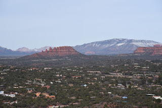
In less than a mile, the route rounds a bend over Carroll Canyon where see-forever looks stretch to the northwest where the elongated profile of the Bradshaw Mountains rise above more classic Sedona landforms including the Cockscomb and the Pyramid.
 |
| Hike begins in Sedona's Sunset Park |
This penultimate scene sets the stage for the main attraction---an up-close encounter with Airport Mesa. The high-elevation, non-towered airport (KSEZ) sits at 4,830.5 feet and was opened in 1955. Its 5,130-foot runways and 50’x50’ helipad serve small aircraft, executive jets, and air tour services. The compact mesa-top site is busiest on the weekends hosting about 96 daily aviation operations. The best chance of being buzzed happens on the Table Top Trail that peels off the loop’s southwest side. The 0.4-mile side trip ascends an ancillary mesa that juts out below the end of the airport runway.
 |
| Cockscomb formation with Red Rock Secret Mountain Wilderness in background |
Along with the intermittent air shows, the trail offers aerial views of Courthouse Rock, Bell Rock and Cathedral Rock that hover above the winding course of Oak Creek.
Yucca, agave and prickly pear cacti line the path as it works its way toward the nose of the isolated land jetty. A slim footpath circles the scenic lookout point serving up some of the most spectacular 360-degree visual overviews of Sedona that do not require a long, difficult trek to attain. The loop then continues along the southeast flanks of Airport Mesa for more deep looks at Oak Creek and juniper fleeced canyonlands before circling back to the start point along Sedona’s urban-forest interface.
 |
| Courthouse Butte, Bell Rock and Cathedral Rock seen from Table Top |
LENGTH: 5.1 miles
RATING: moderate
ELEVATION: 4,317 – 4,719 feet
GETTING THERE:
Sunset Park: 655 Sunset Drive, Sedona.
From the State Route 179/89A traffic circle in Sedona, go 1.9 miles west on 89A (toward Cottonwood) to Sunset Drive. Turn left and continue less than a mile to Sunset Park on the right. Hike begins at the Lollipop Trail near the first parking spaces.
Park hours are dawn to dusk daily. No fees.
INFO:
Coconino National Forest
https://www.fs.usda.gov/recarea/coconino/recarea/?recid=71905


