Find A Trail. Start Your Search Here:

Showing posts with label Fraesfield trailhead. Show all posts

Tuesday, March 19, 2024

Redbird-Gooseneck Loop

RED BIRD-GOOSENECK LOOP

A boulder passage on the Gooseneck Trail

By trail, it’s only 7 miles from the Fraesfield trailhead to the Tom’s Thumb trailhead in Scottsdale’s McDowell Sonoran Preserve Central Region.

Fraesfield trailhead seen from Gooseneck trail

 
Three miles, as the crow flies. The trail miles wind within a narrow strip of Sonoran Desert that sits between the preserve’s north and south regions.  
Snow capped Mazatzal Mountains

Serving as a non-motorized travel corridor and buffer zone between suburbs and wilds, the tiny parcel abuts private property and McDowell Mountain Regional Park with just enough width for a seamless, airy transition.  
Granite formation on the Redbird Trail

While the Central Region of the preserve sees less action than its compatriots, the maze of routes it holds offer less crowded treks with some of the best mountain vistas in the northeast Valley. 
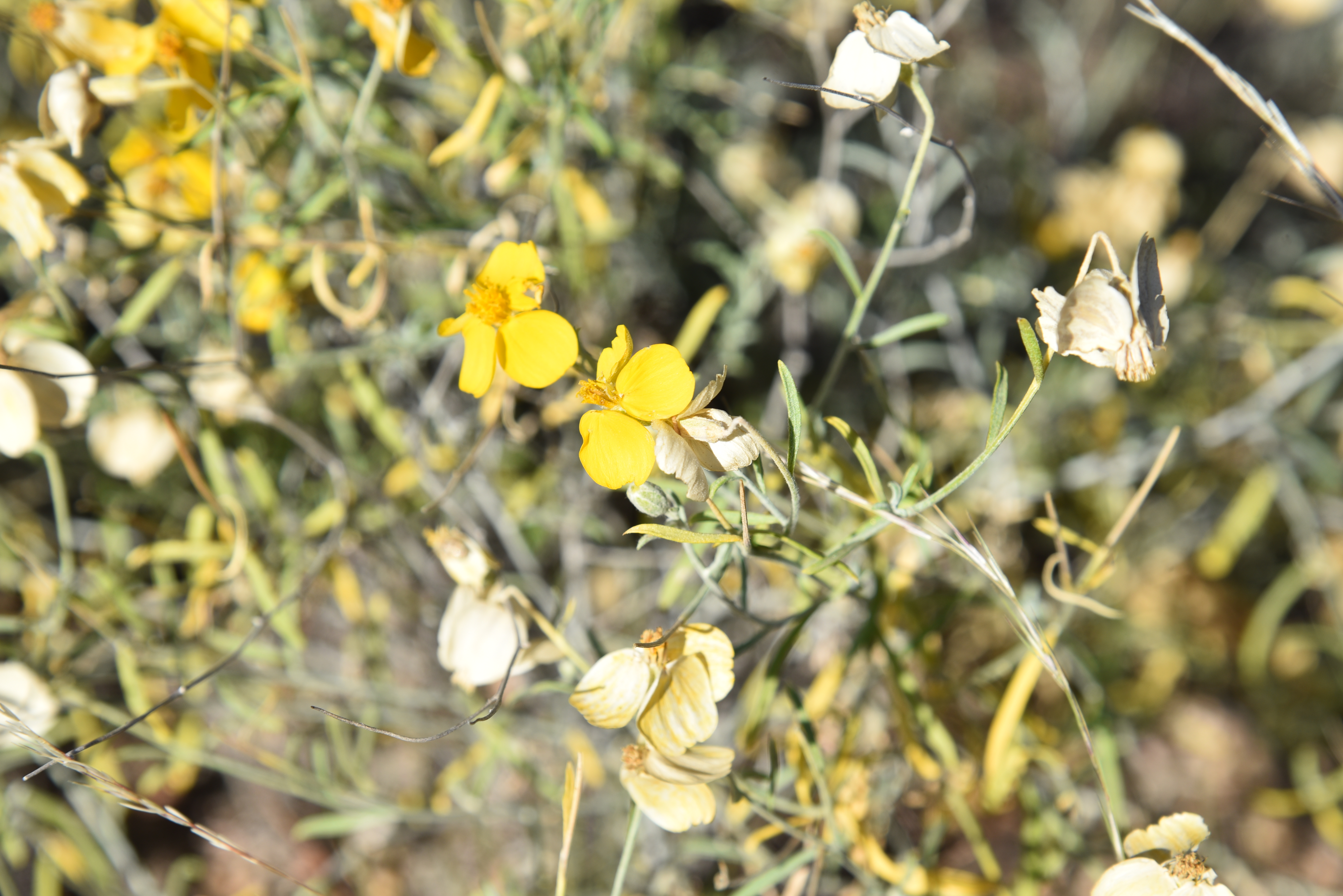
Desert rockpea bloom on the Redbird Trail

The 6.7-mile Gooseneck Trail, which is also part of the 315-mile Valley-circling Maricopa Trail, is the region’s main artery and can be used as the primary path in building customized hikes.
Creosote forest on Gooseneck Trail

From the Fraesfield trailhead, the Gooseneck single track trail heads south in a lazy-S format--much like its moniker suggests.  
Four Peaks seen from Service Road #2

Several short trails, connectors and service roads spin off the curvy, weel-signed conduit for use in creating loops, through hikes or out-and-back treks.  One day hike to try uses the Gooseneck, Redbird and Service Road #2 trails for a tour that includes amazing geology, lush desert vegetation and eye-popping views all around.  
Desert hyacynth (Blue Dicks) on Redbird trail

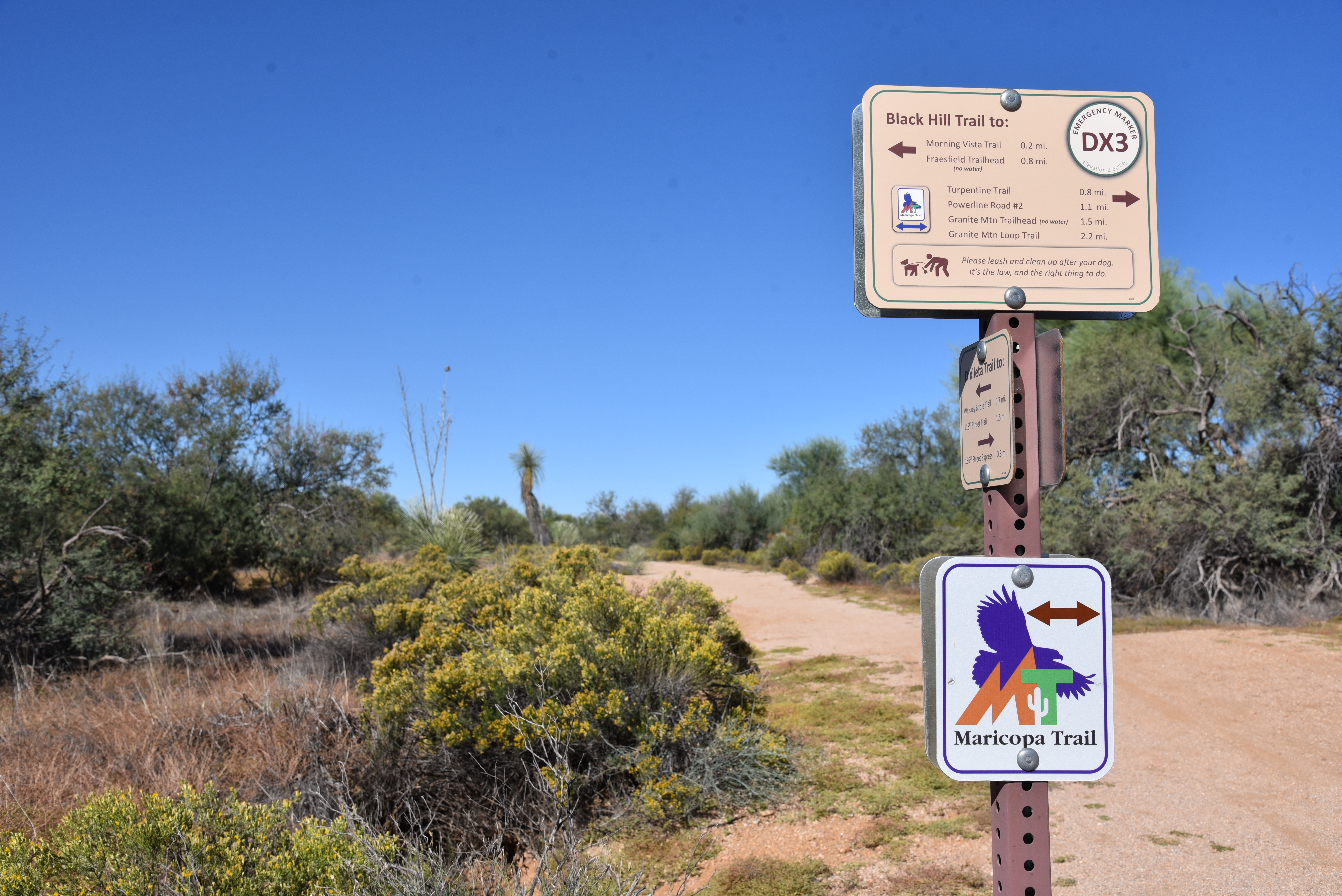
To get the most out of this off-the-beaten hike, spend a few moments at the Fraesfield trailhead mountain-identifying display. The artistic iron display shows the names and elevations of surrounding peaks visible from the trails. 
Mushroom rocks sprout in the Central Region

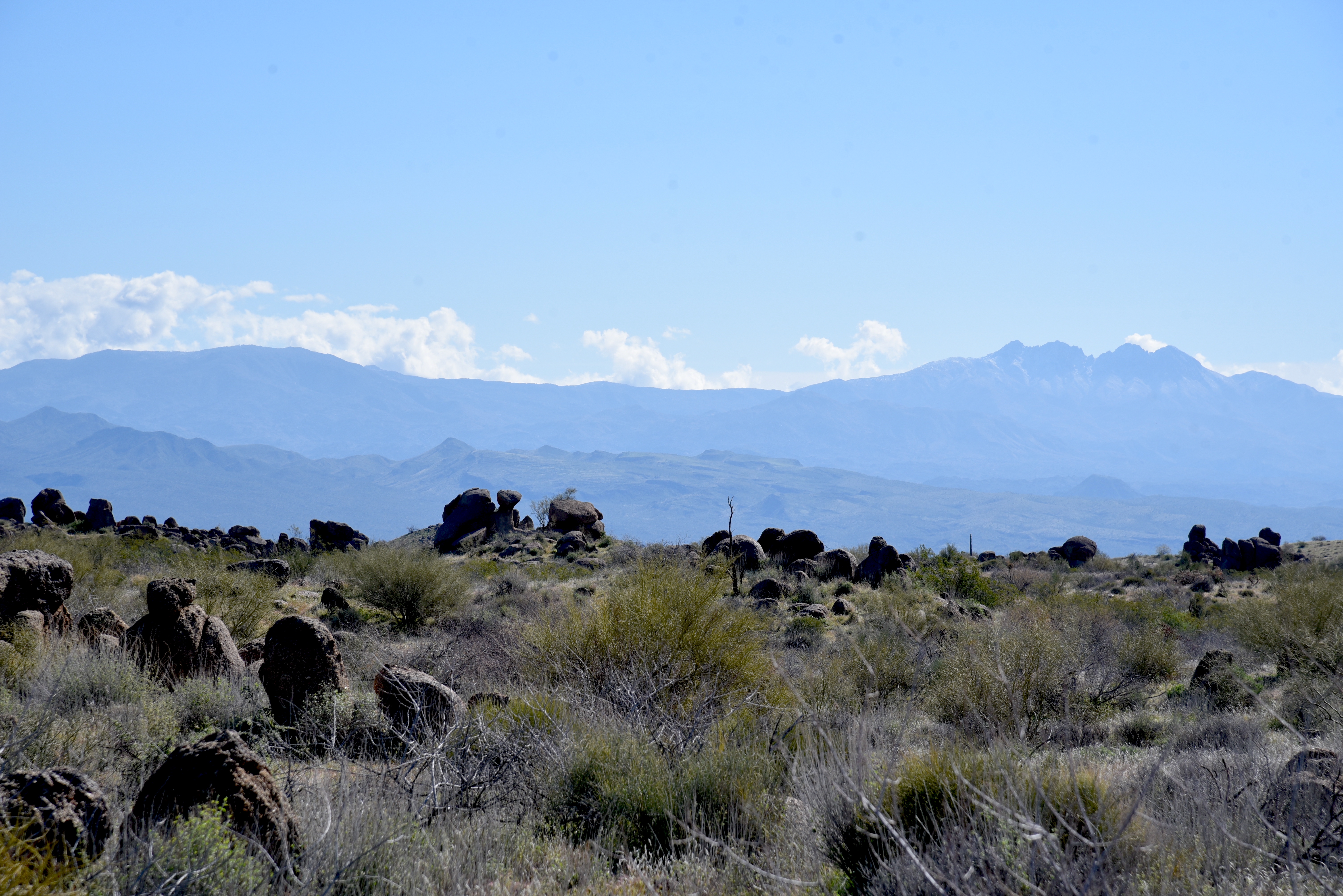
Heading south on Gooseneck, the route winds among saguaros and cholla cactus, crossing Rio Verde Drive at the 0.8-mile point.  Across the road, the vegetation morphs from cactus-centric to a sea of creosote and brittlebush.  The mostly level trail gains elevation gradually, opening magnificent mountain views.  The prominent profiles of Mazatzal Peak, Mount Peeley, Saddle Mountain and Mount Ord stand out to the northeast.
Tom's Thumb seen from Service Road #2

To the southeast, the hazy silhouettes of the Superstition Mountains dominated by Weaver’s Needle and the Flatiron hover over the Salt River basin and Tonto National Forest. 
Wolfberry shrub in a desert wash

The preserve’s famous “mushroom rocks”—granite formations that have been sculpted into bizarre shapes over millions of years by the forces of nature, make an appearance here as well.  At the 1.6-mile point, the route heads west on the Redbird trail. This 1.1-mile segment passes through several glinting stony passages at the hike’s highest elevation with excellent views of  the iconic Tom’s Thumb pinnacle perched atop the McDowell Mountains.  The route then swings east on Service Road #2.  The unsexy name belies a beautiful walk through a wash-riddled landscape where water-loving wildflowers, mesquite and hackberry shrubs thrive in sandy soils.  The road also unveils best looks at the cloud-piercing mounds of the Four Peaks Wilderness Area. 
Superstition Mountains seen from Redbird Trail

Brown's Mtn (L horizon) seen from Service Rd

Where the road meets up with Gooseneck, the route swings back north for the return leg of the hike.  Open to the sky and drenched in the resinous scent of creosote, the homeward trek keeps on delivering goodies.  Look for peeks at the flat-topped form of Brown’s Mountain in the preserve’s north region backed by the sprawling mesas and peaks of the Cave Creek Mountains.  
Fiddleneck bloom on the Redbird Trail

Once explored, it becomes clear that the preserve’s Central Region is much more than just a bland thoroughfare between two supernovas.  Like an Oreo cookie, there’s good stuff in the middle.
Kiosk at Fraesfield trailhead

LENGTH: 6.6 miles roundtrip

RATING: easy

ELEVATION: 2,494 – 2,693 feet

GETTING THERE:

Fraesfield trailhead:

13400 E. Rio Verde Dr. Scottsdale

There are no fees. There are restrooms but no drinking water at the trailhead.

HOURS: sunrise to sunset daily

INFO & MAPS:

Scottsdale’s McDowell Sonoran Preserve

https://www.scottsdaleaz.gov/preserve

Monday, November 29, 2021

Camino Campana

CAMINO CAMPANA

Camino Campana was dedicated on 10-31-21


Desert pop quiz!  What’s metarhyolite?  How many entrance holes are in a packrat midden? What’s the function of a “nurse plant”?  In what ways do dead saguaros benefit the environment?  Stumped? 

Chris & Dawn Vandell of Ftn Hills walk their dog Vinny

To learn the answers to these questions and much more, take a stroll on the Camino Campana in the Scottsdale McDowell Sonoran Preserve. 
Pablo Moyano of Mesa inspects a geology display

The trail is named for Kathryn “Sam” Campana who has been an advocate for environmental issues, a Scottsdale elected official, non-profit executive, arts advocate, volunteer and mover-and shaker in the planning and development of the preserve.  The 0.74-mile, barrier-free interpretive path which loops through breezy desert at the base of Fraesfield Mountain is outfitted with beautifully-illustrated signs and interactive displays. 
Leashed dogs are welcome on preserve trails

Each of the 11 educational stops along the route explores a different aspect of the surrounding landscape.  Hikers will learn about geology, bird nests, human history, archeology, wildlife and plants.  The wide, stroller and wheel chair accessible trail is perfect for those with mobility challenges or wrangling kids while restrooms and shade at the trailhead round out the family-friendly amenities.  
An ersatz mountain lion stalks its prey

The trail also has a surprise lurking in the mesquite that gives hikers a momentary fright. 
A harmless coachwhip snake slithers for cover.

Who lives here? There's a sign for that.

Look for a metal silhouette of a mountain lion stalking its prey that looks startling real from a distance. 
Seven-month-old Vinny strikes a pose.

Dedicated on October 31, 2021, the meandering loop unwinds its instructive gems with intuitive panache.  A kiosk about washes leans over a wash, a sign directing visitors to look to the sky sits below a hillside popular with raptors and a strategically-placed view station with a postcard-style frame and adjacent selfie stand presents an irresistible opportunity to document the trip. 
The Camino Campana is wide and barrier-free

LENGTH: 0.74 mile loop

RATING: easy, barrier-free

ELEVATION: 2,540 ft

GETTING THERE:

Fraesfield trailhead:

13400 . Rio Verde Dr., Scottsdale.

From Loop 101 in Scottsdale, take the Princess/Pima exit 36 and go 6.5 miles north on Pima to Dynamite Blvd./Rio Verde Dr.  Turn right and go 5.6 miles to the trailhead on the left.  There are restrooms but no water at the trailhead.

PRESERVE HOURS: Sunrise to sunset daily. Check website for exact times.

INFO:

https://www.scottsdaleaz.gov/preserve


Tuesday, October 19, 2021

Black Hill Trail

BLACK HILL TRAIL

Scottsdale McDowell Sonoran Preserve

Mount Ord seen from Black Hill trail

Desert mountains everywhere.  That’s the atmosphere on the Black Hill Trail. 

Cholla (L) and Granite (R) mountain

Tethered to the recently upgraded Fraesfield trailhead in the north sector of the Scottsdale McDowell Sonoran Preserve, the smooth and easy path is steeped in mountain views both near and far.
Bees gather pollen from a buckwheat shrub


The 1.9-mile route, which also part of the 315-mile Valley-circling Maricopa Trail, takes off from a shaded trailhead rest area where an artful metal sign identifies the many peaks, mesas and buttes visible from the trail. 

Black Hill trail traces Fraesfield Mountain

Take a moment to appreciate the landmark names and their places in the landscape.

Once something has a name, it’s no longer just an inconsequential encounter or a hazy outline on the horizon, but a real thing-- a character per say-- in your personal explorations. 

Desert marigolds add pops of color to the trail

They become like good friends you’re always happy to meet again and again.
Yuccas are plentiful along the route

Like all trails in the 30,580+-acre north Valley preserve, Black Hill is well-signed, immaculately maintained and designed to guide trail users through some of the area’s most gorgeous vegetation and geological formations.  The 4-mile out-and-back hike begins with a brush by a chain of rounded flanks that comprise 3,055-foot Fraesfield Mountain. 

Saddle Mountain (C) stands out on the horizon

Following an old dirt road, the trail wanders through classic Sonoran Desert vegetation dominated by turpentine bushes, cholla, yuccas, mesquite trees and colorful spots of wildflowers. 
A "Mushroom rocks" sculpture galley

Following a short traipse through sunny rangeland, the route makes a mild uphill climb to where views of distant mountain ranges and peaks appear over acres of palo verde trees and enormous saguaro cactuses. 
Four Peaks viewed from the trail

Look for the familiar forms of Four Peaks (7,657 feet), Weaver’s Needle (4,554 feet), The Flatiron (4,656 feet), Mount Peeley (7,011 feet) and Mount Ord (6,529 feet) as well as other landmarks named on the trailhead interpretive sign.  
Remnants of defunct ranch operations line the route

The far-off stony peaks are countered with equally impressive, trailside rock formations. The mini massifs---often called “mushroom rocks”-- take on bizarre shapes with chock stones and slipped slabs heaped in a sort of natural outdoor sculpture gallery.
Trailhead signage names distant peaks

Black Hill trail is also part of the Maricopa Trail

Throughout the hike, the craggy heaps of Cholla and Granite mountains hover to the north with acres of green desert flora huddled at their bases.  The Black Hill trail ends at the junction with the popular Granite Mountain trail where it’s easy to pick up a connecting path to extend the hike for more mountain immersion and a chance to test your peak-naming memory.

A giant saguaro stands sentry over the trail

Paper flowers bloom sporadically year-round

LENGTH: 4 miles roundtrip

RATING: easy

ELEVATION: 2,514 – 2,667 feet

GETTING THERE:

From Loop 101 in Scottsdale, take the Princess/Pima exit 36 and go 6.5 miles north on Pima to Dynamite Blvd./Rio Verde Dr.  Turn right and go 5.6 miles to the trailhead on the left.  There's a restroom but no water at the trailhead. Preserve hours are sunrise to sunset daily.

INFO:

https://www.scottsdaleaz.gov/preserve


Monday, November 10, 2014

TURPENTINE TRAIL


TURPENTINE TRAIL
McDowell Sonoran Preserve

Who knew that the ambrosial, mood-altering magic of fragrance could be so pronounced on a trail dubbed "Turpentine"?  Named for Ericameria laricifolia, a knee-high bush in the sunflower family, the Turpentine Trail in Scottsdale's McDowell Sonoran Preserve celebrates this tenacious plant's olfactory contribution to desert hiking. Instead of the expected nasal membrane singeing vapors, the needle-like leaves of the turpentine bush emit a complex cloud of piney perfume with hints of citrus and sage when pinched gently between the fingers. The late bloomer is at its best during the winter hiking season boasting yellow, broom-shaped blooms from August through December followed by frothy, flightily seed globes.  The plants grow in perfusion throughout the preserve's sandy, crushed granite terrain but are especially robust in the north sector around the Fraesfield and Granite Mountain trailheads, both of which can be used to access the Turpentine Trail. Maps available online coupled with meticulous on-trail signage show numerous ways to weave this trail into a day of exploring.  One option begins at the Fraesfield trailhead with a 1.6-mile trek on Black Hills Trail, to the Turpentine junction. From here, go left and hike 1.4 miles to Whiskey Bottle Trail, veer left and continue 1.6 miles back to the trailhead. This loop has terrific views of the Superstition Wilderness, Four Peaks and the Cave Creek Mountains.
LENGTH: 4.6 miles as described here
RATING: easy
ELEVATION: 2300' - 2656'
GETTING THERE: Fraesfield Trailhead
From Loop 101 in Scottsdale, take the Princess/Pima exit 36 and go 6.5 miles north on Pima to Dynamite Blvd./Rio Verde Dr.  Turn right and go 5.6 miles to the trailhead on the left.  There's a restroom but no water at the trailhead.
INFO & MAPS: McDowell Sonoran Preserve, 480-312-7013
MORE PHOTOS:

Saturday, January 25, 2014

BLACK HILL-GRANITE MOUNTAIN LOOP


BLACK HILL-GRANITE MOUNTAIN LOOP
McDowell Sonoran Preserve
Granite Mountain Loop

Sandwiched between palm-tree-caressed swaths of upscale homes, sprawling ranches and a wall of 7000-foot-high mountains rising over the Verde River Valley, Scottsdale's McDowell Sonoran Preserve is a refuge for marauding herds of javalina, deer and city dwelling hikers, bikers and equestrians looking to unwind. It's an open, airy place reminiscent of Montana's "big sky county" replete with far-reaching views and western character. The Black Hill Trail delves into the guts of this natural sanctuary, following a wide, decommissioned dirt road lined with jumbo saguaros and thickets of yucca.
Smothered in desert plant life, the area's myriad wildflowers and blooming shrubs erupt in brilliant waves beginning in January when blood-red chuparosa flowers and shock-yellow clusters of desert rock peas serve as opening acts for a riot of color that ends with the annual show-stopping blast of creamy white saguaro blossoms in May.
Black Hill Trail ends at Powerline Road where a battalion of electrical towers strung together over the desert reminds that civilization shares this space.  At this point, a network of connecting trails makes for endless hiking combinations. One to try is the 4.2-mile Granite Mountain Loop, which begins directly across the road. The trail's highest point is 2,780-foot "Scenic Overlook". Here, a patchwork of homes in the valley below mingles with pristine desert and the muted silhouettes of the Superstition Mountains on the southern horizon. Added goodies on the loop include a noble crested saguaro near the Branding Iron trail junction and an optional side trip to geological wonder, Balanced Rock.

Black Hill Trail

LENGTH: 8.8 miles (9.6 miles with Balanced Rock)
RATING: moderate
ELEVATION:  2540' - 2780'
HOURS: open daily sunrise to sunset
GETTING THERE: Fraesfield Trailhead.
From Loop 101 in Scottsdale, take the Princess/Pima exit 36 and go 6.5 miles north on Pima to Dynamite Blvd./Rio Verde Dr.  Turn right and go 5.6 miles to the trailhead on the left.  There's a restroom but no water at the trailhead.

Desert Rock Pea

INFO & MAP: McDowell Sonoran Preserve

MORE PHOTOS:

Sunday, December 1, 2013

WHISKEY BOTTLE TRAIL


WHISKEY BOTTLE TRAIL
McDowell Sonoran Preserve

With its boozy moniker and fresh-cut course, this trail, which departs from  Fraesfield Mountain trailhead, is an intoxicating trek.  Meandering through a seemingly endless expanse of yucca-studded “horse country” the well signed network of trails enables carefree hiking for experts and greenhorns alike. Whiskey Bottle begins with a brief climb along the east flank of Fraesfield Mountain.  Below, a yawning vegetation-rich wash where rain lingers in mud-fringed pools is a favorite “pub” for thirsty bands of local deer, javelinas and coyotes.  The trail’s high point provides a platform to wrangle your bearing by checking out views of surrounding mountains---Four Peaks to the east, white “golf ball” topped Humboldt Mountain to the north and to the distant southeast, the iconic spire of Weaver’s Needle in the Superstition Wilderness cuts a muted lavender silhouette.  The trail scoots along the preserve’s southern boundary passing an upscale golf course near the Dixileta Trail junction.  Although the route’s name suggests otherwise, the only relic of trailside imbibing is a rusted can of Modelo lodged in the roots of a mesquite tree.  However, members of the golf community might get a Manhattan at the club after 18 holes.

Jiding Javelina

LENGTH: 5.8 miles roundtrip
RATING: moderate
ELEVATION:  2540’ – 2764’

GETTING THERE: Fraesfield Mountain Trailhead,
From Loop 101 in Scottsdale take the Princess/Pima exit 36 and go 6.5 miles north on Pima to Dynamite Blvd./Rio Verde Dr.  Turn right and go 5.6 miles to the trailhead on the left. No facilities or water. Trailhead is open daily from sunrise to sunset.

INFO:

Saturday, November 30, 2013

FRAESFIELD TRAILHEAD

Yes---it's open.

Located at the southern end of the new Brown's Ranch extension of Scottsdale's McDowell Sonoran Preserve, Fraesfield trailhead provides plenty of paved parking and access to dozens of  trails, but no other facilities. 2020 UPDATE: restroom, interpretive signs and shade ramadas now installed.

GETTING THERE: 
From Loop 101 in Scottsdale, take the Princess/Pima exit 36.  Go 6.5 miles north on Pima to Dynamite Blvd.(which will turn into Rio Verde Dr). Turn right (east and continue 5.6 miles to the trailhead on the left.
INFO & TRAIL MAPS:
http://www.scottsdaleaz.gov/preserve