Find A Trail. Start Your Search Here:

Showing posts with label Thumb Butte. Show all posts

Monday, September 19, 2022

Honeybucket Loop

HONEYBUCKET LOOP

Prescott National Forest.

View of Granite Mountain from Honeybucket trail

At its core, the Honeybucket Loop is a mashup of old forest roads and adopted social paths tied into a hiking trail.

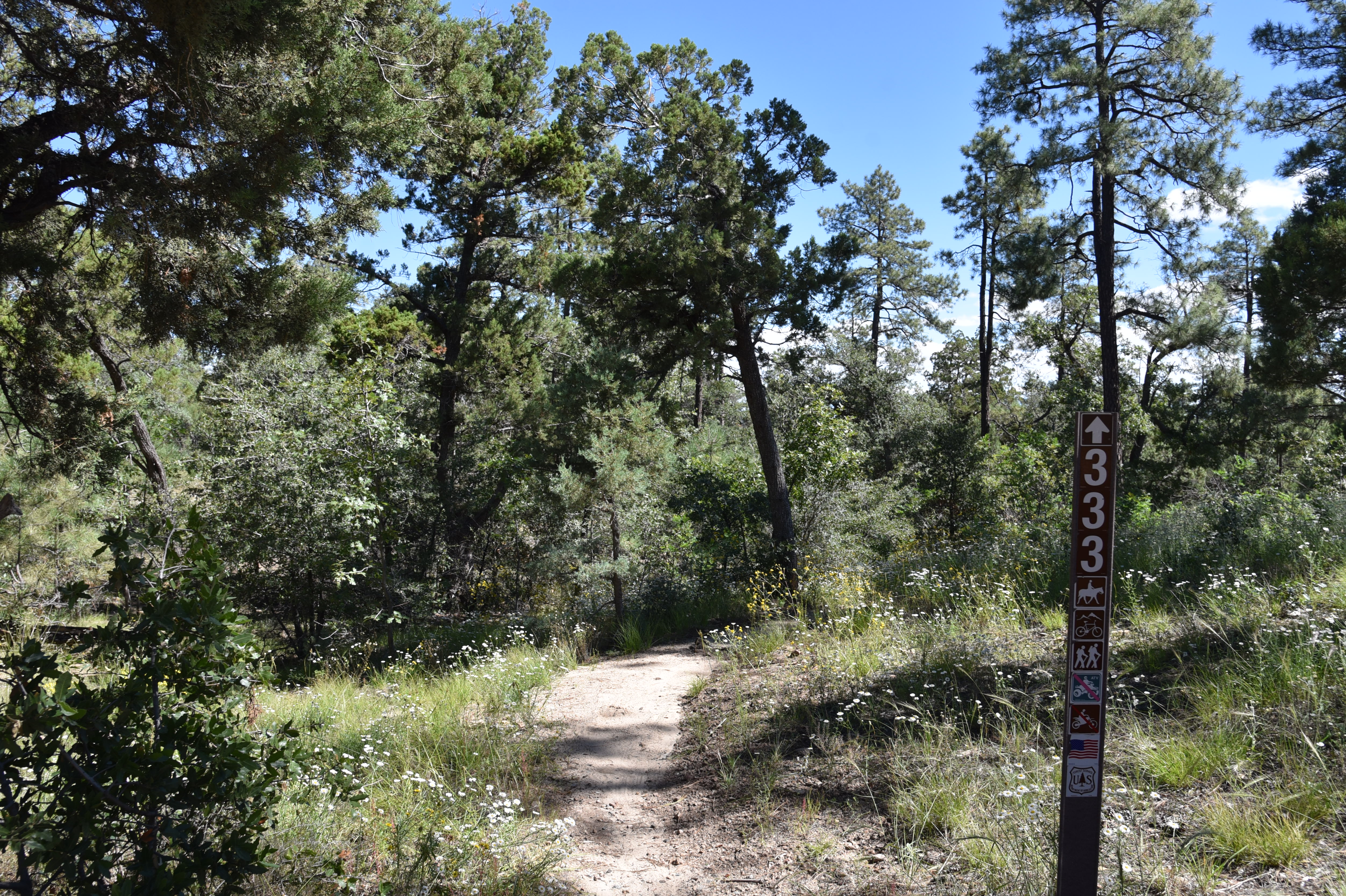
The loop is well signed throughout its 4.6-mile course

 
At its heart, its arguably one of the prettiest little strolls in Prescott National Forest. The route delivers generous servings of mountain vistas, shady forests, interesting geology and late summer wildflowers. It’s a true sweet spot among the dozens of trails that weave through the woodlands around Prescott’s Thumb Butte.
Western dayflowers bloom August - September

The loop is a perennial offering on the Highlands Center for Natural History annual Hiking Spree event. The Hiking Spree challenges hikers to complete 8 out of 10 selected treks over the course of 3 months for a chance to be entered into a prize raffle and purchase a commemorative medallion upon completion.

Thumb Butte peeks through pines on Honeybucket

From a slightly out-there trailhead off Thumb Butte Loop Road just 6 miles west of Downtown Prescott, the circuit begins with a 1-mile walk on the Honeybucket trail #333. 

Western yarrow blooms June - September

Weaving among granite outcroppings and stands of ponderosa pines, this warmup section is ablaze in late summer wildflower color.
A boulder passage on Honeybucket trail

Fleabane, goldenrod, tansyleaf aster, western dayflowers, brickellbush, yarrow, thistle and groundsel add sprinkles of yellow, blue, purple and white in sunny spots. 
Prescott Circle Trail Connector has big views

First peeks at iconic Granite Mountain (7,295 feet) emerge at about the half-mile point where the trail bends northward picking its way through thick scrub and massive alligator juniper trees. The loop portion of the circuit departs from the Thumb Butte Bypass Trail #326 junction. 
View of Granite Mountain from Thumb Butte Bypass

Alligator juniper on the Thumb Butte Bypass

From the junction, continue hiking on Trail #333 as it makes a mild descent toward Butte Creek through a more open terrain with see-forever views of the Sierra Prieta mountain range.
Fleabane decorate the loop May - October

 
Trailhead is a dirt pull off on Thumb Butte Loop Road

The trail traverses green gullies and drainages before meeting up with the Prescott Circle Trail Connector Trail #322.  Go left at the junction and follow this 0.7-mile segment while watching for fleeting glimpses of Thumb Butte ( 6,514 feet) and the Williamson Valley that peer out between breaks in tree cover.  The last arc of the loop starts at a major intersection where the circuit heads left on the Thumb Butte Bypass Trail #326. 
The circuit crosses ravines and drainages

Arizona thistle blooms May - October

This 0.6-mile segment follows an old dirt two-track that makes a gradual climb beneath a pine-oak-juniper canopy with fields of hip-high grasses tangled with blooming shrubs lapping at the ankles.  More peeks at Granite Mountain and Thumb Butte punctuate the skyline before the trail reconnects with the Honeybucket trail for a rewind back to the trailhead. While it’s short and just moderate in its physical demands, the Honeybucket loop never scrimps on visual richness, making it a fine choice for appreciating the flora and mountain terrain of Prescott forests.
Wildflowers blanket a section of Honeybucket trail

LENGTH: 4.6 mile loop

RATING: moderate

ELEVATION: 6,094 – 6,400 feet (703 feet of accumulated elevation change)

GETTING THERE:

From Courthouse Plaza in downtown Prescott, go west on Gurley Street , which turns into Thumb Butte Road.  Continue 5.2 miles, passing the Thumb Butte and White Rock trailheads, to Thumb Butte Loop Road (Forest Road 373) on the left. Follow FR 373 for 1.6 miles to the turn off for Forest Road 51 on the left where there’s a dirt parking apron at a Trail 333 sign.

Thumb Butte Loop Road is washboard rough with some potholes but is passible by most carefully-driven vehicles. The road is not maintained in winter.

INFO:

https://highlandscenter.org/hiking-spree/

https://highlandscenter.org/wp-content/uploads/Honeybucket.pdf


Tuesday, March 12, 2019

FIREWATER LOOP

FIREWATER LOOP

Prescott National Forest
South Fork of Willow Creek spills over the Javelina Trail.
The constantly evolving and growing system of woodsy trails surrounding Thumb Butte in Prescott National Forest has a new darling. Although the former social trail (a user-built, unsanctioned path) had been around for a while, it was only recently adopted, rerouted, signed and officially named the Firewater Trail No. 325  by the forest service and group of Prescott-area volunteers known as the Over the Hill Gang.
Wild candytuft blooms along the trails Feb-Aug.
An edgy section of the Firewater Trail.
Since this 2017 debutante is located inland from trailheads, it’s necessary to build an outside-in plan to reach it. There are many options for tying it into a day hike circuit including a loop that begins at the new White Rock trailhead off Thumb Butte Road just 5 miles from downtown Prescott. 
Signs at the beginning of the loop portion of the hike.
With its stimulating blend of water, far-reaching vistas, historic artifacts and several bio-zones, the moderate, three-trail circuit is bound to become a classic.
Corral on the Javelina Trail.
Creek crossing near the Javelina-Firewater junction.
Start on the West Trail No. 318, which is also part of the Prescott Circle Trail--- a 55-mile route that wraps around town.  Ponderosa-pine-shaded and replete with gigantic granite boulders and trickling drainages, West Trail is an effortless 0.5-mile traipse up to the Javelina Trail No. 332 junction---the beginning of the hike’s loop section. Veer left and follow Javelina Trail through an undulating terrain flanked by alligator junipers, manzanitas, oaks and mossy ravines. Much of this deeply forested segment traces trickling drainages and the South Fork of Willow Creek.
Granite Mountain seen from the Firewater Trail.
Roughly 1.4 miles from the junction, the trail bends right into a rocky, willow-cluttered  corridor, crosses the creek and heads uphill into a clearing with an old corral.  This rustic pastoral scene culminates at a clearing with ruins of an old stone chimney where the route heads right, crosses the waterway again then swings right (avoid the social trail that goes left) and connects with Firewater Trail No. 325.
Javelina Trail passes by Thumb Butte.
The 1.2-mile leg begins with an edgy climb on the slopes above the creek that plows through some of the most stunning scenery of the loop. Deep canyons, steep drop offs and lots of shade make the twisting course a joy to hike and an all-too-short dip into a rich pocket of Prescott National Forest. 
The route crosses several drainages.
Where the route leaves the deep woods and  bumps back into Trail No. 318, head right for the view-centric return leg. Here, high ridge vantage points showcase multi-level mountain vistas. 
Granite boulders on the West Trail.
In the foreground, the massive hulk of Granite Mountain commands the landscape.
Prescott Valley seen from West Trail.
Farther out, a dim chain of peaks that includes Bill Williams Mountain, Kendrick Mountain and the San Francisco Peaks appear as vague humps jutting above a sea of pines and the plains of Prescott Valley.  At several turns along the final mile, Thumb Butte peeks out from breaks in the pinion pine cover, signaling the end of a short but multi-faceted trek.
Part of the Javelina Trail flanks the So. Fork of Willow Creek.
White Rock trailhead on Thumb Butte Road opened in 2018.
LENGTH: 5.3 miles
RATING: moderate
ELEVATION:  5614 – 6010 feet
GETTING THERE:
From Courthouse Plaza in historic downtown Prescott, go 5 miles west on Gurley Street (turns into Thumb Butte Road) to the large White Rock trailhead on the right. Roads are 100% paved. No fees or facilities.
INFO:
City of Prescott
Prescott National Forest
https://www.fs.usda.gov/prescott
-->

Tuesday, May 29, 2018

BUTTE CREEK TRAIL
Butte Creek Bridge at Stricklin Park
Besides packing the usual gear and water, hikers on Prescott’s Butte Creek Trail #321 should be prepared to duck.  That’s because the 1.6-mile city-managed section of the route passes through the private Hassayampa Golf Club.  
Part of the trail goes through a private golf community 
This pleasantly diverse pathway that skirts manicured greens and glass-faced homes with wrap-around balconies provides alternative access to the Thumb Butte Area in Prescott National Forest.  The trail begins at Stricklin Park where a bridge embellished with whimsical dragonfly sculptures crosses Butte Creek.  
Fragrant cliffrose
Even in drier years like this one, the creek corridor is alive with greenery.
Canyon grapes thrive near the creek
Massive Fremont cottonwood trees sway above a meandering strip of willows, oaks, wild roses, reeds, Canyon grape vines and boxelders.  The well-marked trail wanders through a shady, boulder-lined woodland before it crosses another bridge and enters the golf community property.  The slim path is open to all for recreational use, but you must stay on the trail.  The next mile explores the suburban-forest interface passing by emerald greens, golf cart paths and steep-walled riparian ravines where humid pine-moss-addled air mingles with the scent of cliffrose and fresh cut grass. 
A pine-shaded passage of Butte Creek Trail
As the trail gains elevation, the iconic form of Thumb Butte rises to the north followed by views of Prescott Valley, the Bradshaw Mountains and the peaks of Flagstaff.  At the 1.6-mile point, the trail enters Prescott National Forest. For a short stretch beyond the boundary gate, the trail moves through a forest clearing full of not-so-pretty slash piles (cut branches staged for burning or removal) but soon regains its beauty in a woodland dominated by Scrub live oak, manzanita and Ponderosa pines. 
Riparian vegetation on Butte Creek Trail
After 0.7-mile, the path meets the first of several junctions that connect with the Thumb Butte Area trail system. 
Thumb Butte seen from forest boundary
Download the forest service map to customize a long loop or head back the way you came (watching out for errant white balls flying among scrub jays and ravens) and take a walk around 5-acre Stricklin Park where you’ll find an archeological site with interpretive sign.
Greenery along Butte Creek
Claret cup cacti bloom along the trail May -July.
LENGTH: 6.2 miles out-and-back
RATING: moderate
ELEVATION: 5450 – 6100 feet
Watch out for flying golf balls.
GETTING THERE: 
Stricklin Park Trailhead: 1751 Sherwood Drive, Prescott.
From downtown Prescott, travel 1.8 miles west on Gurley Street to Sherwood Drive. Turn left and continue 0.2 mile to the Strickland Park sign on the left. Park along the street.
INFO & MAPS:

Monday, July 24, 2017

PINE LAKES TRAIL #316

PINE LAKES TRAIL #316

Thumb Butte North Trails
Pine Lakes Trail flanks Willow Creek 
Pick a day following a good monsoon soaking to hike Pine Lakes Trail #316.  That way, you’ll have the best chance to see the tiny waterfalls that tumble over logs and rocks in Willow Creek.
Canyon grapes grow along the creek
Arguably the most ecologically diverse route in the north segment of Prescott’s Thumb Butte Recreation Area, trail #316 packs a lot of interesting elements into its short length. The first half-mile of the trek moves through an exposed landscape of juniper and oak under the imposing pinnacle of Thumb Butte.
The trail climbs easily to a point where the Bradshaw Mountains peek out from behind the butte before beginning its descent into the riparian corridor of Willow Creek. 
A post-monsoon mini waterfall
As the trail switchbacks down into the gorge, the vegetation makes an abrupt shift from sparse scrub and cacti to rich greenery shaded by arching oaks and soaring Ponderosa pines. The creek trickles in lazy bends with multiple drainages emptying into its course. Over the next mile, the trail stays close to the water crossing it several times. A pleasant mist laced with the earthy aromas of pine needles, wildflowers and mushrooms drifts through the air. The creek itself is a mix of rapid flows, mini waterfalls, standing pools and rivulet-carved sandbars decorated with critter footprints.
Mushrooms thrive in the moist creek corridor
This is an excellent place to take in the wonders of nature's ecosystems and micro climates. 
A crossing of Willow Creek
Plants found within this moist passage couldn't survive well just a couple hundred feet above on the dry chaparral. And although the distance from ridgeline to creek is minimal, temperatures along the waterway are noticeably cooler. The trail makes one last creek crossing before heading back up to the lip of the gorge where the bare rock mound of Granite Mountain can be seen in the distance. From this point, you can retrace your steps for an out-and-back trip or use the map available at the trailhead to create your own circuit.
Thumb Butte
LENGTH:  1.5 miles one-way
RATING: moderate
ELEVATION: 5800’ – 5600’
Granite Mountain in distance
GETTING THERE:
From the courthouse in downtown Prescott (Gurley St. and Montezuma), travel 3.4 miles west on Gurley Street (turns into Thumb Butte Road) to the Thumb Butte Recreation Area. To find the trailhead, hike or dive another 0.1 mile up the paved access road and look for the sign across from the restrooms. 
HOURS: Summer hours (May- Sept) 6 a.m. to 8 p.m. daily.
FEE: There’s a $5 day use fee per vehicle. Bring exact change for the self-serve pay station.
INFO & MAPS:

Monday, October 27, 2014

SOUTH THUMB BUTTE TRAILS


SOUTH THUMB BUTTE TRAILS
Prescott
Thumb Butte Bypass Trail follows Miller Creek

Soaring to 6514', the sky dominating profile of Thumb Butte is Prescott’s most iconic natural landmark. Its convenient location in the middle of a park just west of downtown's historic Whiskey Row attracts scores of visitors, many of whom use the main Trail #33 as their first exposure to Prescott area hiking. Although it's a good choice for novice hikers or those unfamiliar with the area's terrain, a slew of connecting routes add length and difficulty to satisfy the predilections of most trekkers.
The heaviest traveled of the seven routes in the park's south end, Trail #33 is engineered with climb-calming switchbacks, safety rails and rest stops that make short work of the 2.1-mile loop around the granite formation.  When hiking clockwise from the trailhead, the path is paved up to the loop's highpoint on a saddle below vertical rock slabs forming the butte's summit. Here, a spur trail that's closed from February 1st to July 15th each year to protect peregrine falcon nesting sites, leads to optional rock scrambling routes.  The trail turns to dirt for the return leg, passing a makeshift memorial to the 19 Granite Mountain Hotshots who perished in the 2013 Yarnell Hill wildfire.    Maps available at the trailhead show the lay of the land and numerous ways to explore deeper into Prescott National Forest including easy connectivity with the Prescott Circle Trail that makes a 50-mile circuit around the city.
Thumb Butte

LENGTH: 8.3 miles total for 7 trails
RATING: moderate
ELEVATION:  5705’ – 6314’ (Trail #33)
HOURS: seasonal 7 a.m. to 5, 7 or 8 p.m.
FEE: $5 day use fee (exact change required)

GETTING THERE:
From the courthouse in downtown Prescott (Gurley St. and Montezuma), travel 3.4 miles west on Gurley Street (turns into Thumb Butte Road) to the Thumb Butte Recreation Area.
INFO & MAPS: Prescott National Forest