BLACK MOUNTAIN CANYON
 |
| Parsons Tank on FR 9243B in Prescott NF |
It’s just 582 feet downhill from the paved byway of State Route 260 to the rocky course of Black Mountain Canyon but hiking the dirt back road to get to get to it is deceptively more complicated. Located in a hilly section of the Upper Verde River Volcanic Field in Yavapai County 15 miles east of Camp Verde, Forest Road 9243B cuts through dramatic terrain with a backstory of lava flows, ash deposits, water-scoured canyons and countless geological disruptions.
 |
| The rocky course of Black Mountain Canyon |
The rough two track heads north from a dirt pull out along SR 260 in Prescott National Forest on a roller coaster style course that challenges hiking legs with over 1,000 feet of elevation change and delights the eyes.
 |
| Bill Williams Mountain on far right horizon |
 |
| Cliff-rose bloom April - September |
The sparsely shaded road wastes no time delivering outstanding vistas and a tour of the area’s diverse eco-zones. The trailhead is bolstered by two volcanic land forms one being Thirteenmile Rock Butte (5,515 feet) a prominent basalt-topped formation that served as a waypoint on the historic 200-mile General Crook Trail built in the 1800s to connect a chain of military forts that ran from Eastern Arizona along the Mogollon Rim to the Prescott area.
 |
| Yucca bloom April - July |
 |
| FR 9243B goes between two volcanic buttes |
The other geological standout is an unnamed 5,283-foot volcanic pinnacle with a broken east flank that exposes a base of red and black cinders. Forest Road 9243B begins with a run right between the two stony massifs.
 |
| Exposed red cinders tumble from a volcanic butte |
Open to off-road vehicles, hikers, bikers and equestrians, the road is a scenic destination for any type of travel, although, the many details along its course are best observed on foot.
 |
| Velvet ash trees line the road near Black Mtn Canyon |
Within the first quarter mile, the road hits a high point overlooking the Verde Valley. On clear days, the distant silhouette of Bill Williams Mountain near the City of Williams can be seen standing over green valleys and red rocks on the northwest horizon.
 |
| Rabbit thorn blooms April - June |
The route then makes the first of several dips-and-climbs passing by the exposed cider pit before rounding uphill again for another big vista moment before it begins an undulating downhill spiral.
 |
| FR9243B traces the edge of Black Mountain Canyon |
At the 0.8-mile point, the route continues straight ahead where an unmarked dirt road (FR9243C) veers to the left. Vegetation along the first mile is of the typical high desert variety. Yucca, junipers, rabbit thorn, cliff-rose, scrub oak, skunk bush and cacti dominate the landscape with an understory of primrose, lupines, lilies, wild carrot and other wildflowers coloring the loose cinder-strewn substrate.
 |
| Thirteenmile Rock Butte |
Following a steep downhill section, the water of Parsons Tank comes into view in a juniper-ringed depression.
 |
| Verde Valley view from FR 9243B |
The road swings around the tiny pool where the footprints of skunk, bobcats, deer and raccoons signal the importance of this created waterhole to wildlife. Yet another uphill section lands hikers at a gorgeous vista point above the final descent to Black Mountain Canyon.
 |
| Delicate American carrot bloom March - May |
 |
| Verde Valley viewed from Parsons Tank |
On the last edgy plunge, vegetation gradually changes from desert to riparian with ash trees and fruit-bearing shrubs entering the mix.
 |
| Pursh plantain bloom February - July |
The road meets the canyon bottom at the 2-mile point. Marked by a tree-lined boulder crossing, the major drainage makes for a good turnaround point. But the hike may be extended on a maze of dirt roads shown on the Prescott National Forest map.
 |
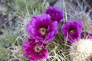
| Strawberry hedgehog cactus bloom Mar - May |
LENGTH: 4 miles round trip
RATING: moderate
ELEVATION: 4,374 – 4,956 feet (1,077 feet of accumulated elevation change)
GETTING THERE:
From Interstate 17 in Camp Verde, take the State Route 260 exit 287 and continue 15.7 miles east (toward Payson) to Forest Road 9243B on the left just past milepost 234. Pass the gate (close it behind you) and park in the turn outs along the road.
INFO:


