Find A Trail. Start Your Search Here:

Showing posts with label Phoenix Sonoran Preserve. Show all posts

Tuesday, February 19, 2019

Badger Brawl-Cliff-Walk-Esplanade Loop

Badger Brawl-Cliff-Walk-Esplanade Loop

Phoenix Sonoran Preserve
Mountain views on the Esplanade Trail
If the human brain has a “dangerous things archive”, an image of a roaring desert wash ought to be seared into it. 
This hike exposes the power of running water.
For Arizonans especially, the fear of running water should rank right up there with snakes and heights.  Although storm water raging through usually-dry channels solicits choirs of oohs and ahhs, the flows are definitely not something to mess with.
Creosote smells wonderful after rains.
They can go from trickle to torrent in minutes.  Driving, riding or hiking through them is extremely risky and potentially deadly. Need more evidence? Next time you’re hiking by a creek or wash, look up into the trees. Those wads of debris dangling high above mark where the water was.
Wash and creek bed crossings are key features of the hike.
That’s why it’s always smart to steer clear of trails that cross waterways until the swells subside. It only takes a day or two for the trails and crossings to dry out enough to pass through safely. Also, not using trails when they are wet and soggy helps prevent the kind of damage that ruins drainage systems, creates dangerous conditions and encourages the blazing of “work around” paths that destroy native vegetation.  
Skull Mesa framed by greenery around Apache Wash
A good place to observe the force of water in a desert landscape is in the north sector of the Phoenix Sonoran Preserve. Hedged between the Carefree Highway and Sonoran Desert Drive east of Interstate 17 in north Phoenix, the chunk of pristine desert holds many surprises.
The trails here offer a diverse menu of options including moderate ridgeline rambles, barrier-free strolls and easy explorations of the wily water alleys that permeate the area. 
A healthy saguaro on Badger Brawl Trail.
A hike on the easy-rated Badger Brawl-Cliff Walk-Esplanade loop on the preserve’s far east end is one of the best ways to explore the transformative powers of water.
Using trails when they are wet causes damage like this.
The circuit begins with a short walk on the Apache Wash Trail which traces a ragged drainage fringed with greenery.  Soon, the trail dips into the first of several wash crossings where signs warn not to attempt when water is running. 
Ironwood trees dot the desert plains.
The circuit is flat and easy.
Above the washes, sunny stretches of classic desert are dotted with saguaros, cholla and isolated patches of mesquite and Palo Verde trees that throw bits of shade on a flatland littered with basalt lava blobs and milky quartz.
Filaree or Stork's Bill grows along the trails.
Where the route wanders through open desert, mountain views--dominated by Skull Mesa and Black Mountain to the north--bolster the horizons.  
Heed this warning.
The  2.9-mile Cliff Walk Trail tethers the three legs of the loop with a traverse of the banks above the Cave Creek river channel. Scattered boulders, plant dregs and frazzled edges of the waterway document the ferocity of flash floods.
Phoenix Sonoran Preserve Trails are well-signed.
The return leg of the trip follows the level grade of the Esplanade Trail--an unfettered space of quiet beauty safe from the sporadic deluges of creeks and washes.
Black Mountain (right) seen from Apache Wash Trail.
LENGTH:  8.56 miles
RATING: easy
ELEVATION: 1720 - 1910 feet
GETTING THERE:
Apache Wash Trailhead, 1600 E. Sonoran Desert Drive, Phoenix.
From Loop 101 in north Phoenix, take Cave Creek Road exit 28 and go 4.5 miles north to Sonoran Desert Drive. Turn left (west) and continue 3.5 miles to the trailhead on the right. The preserve is open daily from sunrise to sunset. There are restrooms but no water at the trailhead.
HIKE DIRECTIONS:
From the trailhead, follow Apache Wash Trail (AW) 0.5-mile to Badger Brawl Trail (BB). Continue 1.55 miles on BB to Cliff Walk (CW) and hike it 2.9 miles to where you’ll swing back on the Esplanade Trail (E).  There’s a shortcut roughly halfway up CW that cuts 2.25 miles off the big loop. Follow Esplanade 3.4 miles back to AW, veer left and hike 0.73 mile back to the trailhead.
INFO & MAPS:

-->

Monday, November 28, 2016

RIDGEBACK OVERLOOK-APACHE VISTA CIRCUIT

RIDGEBACK OVERLOOK-APACHE VISTA CIRCUIT
Phoenix Sonoran Preserve
Ridgeback Trail
Hikers approach the Ridgeback Overlook 
There's no better time than around the holidays to take advantage of the head-clearing benefits of hiking. When overwhelmed by travel plans, entertaining guests, shopping, decorating and hyper-excited kids, sometimes you just need to break away and breath on a peaceful mountain top. You don't have to drive far, load down on heavy duty gear or spend an entire day in the wilderness to get to such a place. In fact, if all you have is a few hours to spare, you can still knock off a double header high point trek in the Phoenix Sonoran Preserve. Beginning at the Apache Wash Trailhead, follow Sidewinder Trail 0.86 mile to the Apache Vista turnoff. This 0.51 mile spur trail circles over two minor peaks above sprawling desert arroyos where on most mornings, commercial hot air balloons float overhead.
Apache Vista Trail
Enjoy the show then descend and continue 0.3 mile on Sidewinder then turn left onto Apache Wash Trail, hike 0.4 mile an turn right on Ocotillo. From here, follow the signs to Ridgeback Overlook for a second short loop on a desert mountain peak. If you're satisfied with just this double peak circuit, hike back down to Ocotillo Trail and hoof it back to the trailhead. Otherwise, download the preserve map and make a day of it on the more than 35 miles of trails that criss-cross the preserve's northern sector.
Ridgeback Overlook Trail
LENGTH: 5.1 miles round trip
RATING: moderate
ELEVATION: 1720' - 2002'
GETTING THERE:
Apache Wash Trailhead, 1600 E. Sonoran Desert Dr., Phoenix.
From Loop 101 in north Phoenix, take Cave Creek Road exit 28 and go 4.5 miles north to Sonoran Desert Drive. Turn left (west) and continue 3.5 miles to the trailhead on the right. The preserve is open daily from sunrise to sunset. There are restrooms but no water at the trailhead.
INFO & MAP:

Monday, May 23, 2016

TAKE A HIKE. DO IT RIGHT.

SIDEWINDER-OCOTILLO TRAILS
Phoenix Sonoran Preserve, North

Sidewinder Trail near Desert Hills Trailhead

We desert dwellers have been lucky this year. May temperatures have been more balmy than blistering, thus extending our cool-weather hiking season by several weeks. But, we all know what's coming--triple digit heat and the ominous whir of rescue helicopters circling above Valley trails. Each year, more than 200 hikers get into trouble on local paths. Although accidents do happen, emergencies like dehydration and heat exhaustion are avoidable. At the new Desert Hills Trailhead that was opened last week, a colorfully illustrated sign gives concise pointers on how to stay safe. The new site provides access to more than 35 miles of trails in the north end of the Phoenix Sonoran Preserve including the two longest routes, Sidewinder (6.98 miles) and Ocotillo (6.25 miles). Sidewinder makes a roller coaster style swing up and around the preserve's hills while Ocotillo wanders along the lower slopes. The trails head out in opposite directions and reconnect at the preserve's southern Apache Wash Trailhead for a 13.23-mile loop. If you're not interested in a long trek, a map kiosk at the trailhead shows how to use any of the 11 connecting paths to suit your fancy. All preserve routes are well-signed and sustainably designed, however, hiking these beautiful trails could be deadly for those who are unprepared for heat and rocky, thorn addled desert terrain.
The trailhead sign outlines the Take a Hike, Do it Right campaign that was rolled out last year to promote preparedness. Most of the tips are no-brainers, such as, bring plenty of water, hike in early morning, wear sturdy shoes and stay on designated trails. Skilled trekkers are not immune. (In the human brain, it seems the confidence synapse lives next door to the one for risk taking). Think about it--news coverage of trail tragedies often describe the victims as "experienced hikers". So, while checking out the Valley's newest trailhead, take a few minutes to review the Do It Right sign. Being properly supplied and geared up will enhance your hiking enjoyment while assuring that the trail photos you posted to social media don't become "before" images on the evening news.
Desert Hills Trailhead

LENGTH:
Sidewinder: 6.98 miles one way
Ocotillo: 6.25 miles one way
RATING: moderate
ELEVATION: 1,720' - 2,002'
Ocotillo Trail
GETTING THERE:
Desert Hills Trailhead:
705 W. Carefree Highway (7th Ave. & Carefree Hwy.), Phoenix.
There's plenty of parking, equestrian lot, shade ramada with seating, restrooms, but NO WATER.
INFO & MAP: City of Phoenix
Take A Hike, Do It Right:

Wednesday, May 4, 2016

NEW TRAILHEAD IN PHOENIX SONORAN PRESERVE

Desert Hills Trailhead Grand Opening: May 21, 2016
Sidewinder Trail, Phoenix Sonoran Preserve

Grand Opening ceremonies for the Desert Hills Trailhead in the Phoenix Sonoran Preserve will be held Saturday, May 21, 2016.
VIP remarks, ribbon cutting and ranger guided hikes will mark the festive occasion.
Located along Carefree Highway in the preserve's north sector, this eco-friendly site will provide plenty of parking and easy access to over 35 miles of pristine desert trails. The trailhead has restrooms but no water.

DATE: Saturday, May 21, 2016
TIME: 8 a.m.
WHERE: 705 W. Carefree Highway, Phoenix (Carefree Hwy. & 7th Ave.)
INFO: City of Phoenix Natural Resources Division, 602-495-5458
natural.resources.pks@phoenix.gov
MAPS & TRAIL INFO:
https://www.phoenix.gov/parks/trails/locations/sonoran-preserve

Tuesday, November 3, 2015

APACHE WASH LOOP

APACHE WASH LOOP
Phoenix Sonoran Preserve
Apache Wash Loop Trail

In an environment where plants and animals must adapt and invent to survive, desert washes play a critical role in managing life's most precious commodity. These serpentine natural gutters corral and horde rain water in ways that create ribbon-like forests and natural underground reservoirs.
A sure-fire way to get an education about the transformative power of washes is to take a hike on the Apache Wash Loop Trail in the Phoenix Sonoran Preserve. The trail dodges through and around a water-scoured furrow and its companion linear oasis that coils through flatlands below a chain of minor desert peaks.
The rugged, tree-lined trench is scoured by storms that come mostly in torrential bursts accompanied by churning clouds and lightning theatrics. During these downpours, massive walls of water roll off surrounding slopes into low lying channels forming transient rivers of debris. Flowing washes are far more dangerous than they appear, so to avoid being swept away, never attempt to hike (or drive) through one while water is running. There are warning signs where the trail crosses the wash, so pay heed. Porous soils soak up the rainfall almost as quickly as it appears but the benefits are long-lasting. The fringe of green lining the wash is made up of deep-rooted trees and shrubs like mesquite, palo verde, catclaw and ironwood that tap into underground water reserves. This tightly woven community of desert adapted plants huddled among water-tumbled boulders, sandbars and super size saguaros provide pleasant shade spots along the route. Although wildlife is most active at dawn and dusk, javelina wallows, nests and burrow diggings belie a robust critter population dependent on the wash and its reliable stashes of water and food.
The easy loop trail is simple to follow and offers both shortcut options and access to an optional summit climb. Posts at every junction show your position, distance and elevation. After hiking the loop, take a side trip up to Apache Vista to get a bird's eye look at the meandering miracle of the wash.
LENGTH: 6.7 miles (including access trails)
RATING: easy
ELEVATION: 1700' - 1820'
GETTING THERE:
Apache Wash Trailhead.
1600 East Sonoran Desert Drive, Phoenix.
From Loop 101 in north Phoenix, take Cave Creek Road exit 28, go 4.5 miles north to Sonoran Desert Drive, turn left (west) and continue 3.5 miles to the trailhead on the right.
INFO & MAPS: Sonoran Preserve Ranger Office: 602-262-7901

Sunday, November 10, 2013

New Phoenix Sonoran Preserve trails


APACHE VISTA & RIDGEBACK OVERLOOK CIRCUIT
Phoenix Sonoran Preserve, North

Climbing Ridgeback trail

On Saturday, November 9, 2013,  former Phoenix mayor Skip Rimza and other city officials dedicated the Apache Vista trailhead amid a crowd of eager Valley hikers, bikers and equestrians. With 21 miles of new trails, deciding where to begin exploring this northern extension of Phoenix Sonoran Preserve can be a dilemma. Suggestion---head for the hills. Ridgeback Overlook and Apache Vista are highpoints capping this cluster of Sonoran Desert trails.  A map board at the trailhead shows how to cobble together a route to climb to both hilltops.  The peaks each have short loop trails winding over the cholla-encrusted summits that give excellent 360-degree views of both the trail system layout and iconic Valley landmarks.
Looking south from Sidewinder trail

HIKE DIRECTIONS:
From the trailhead, hike north on Sidewinder to Apache Vista.  After ascending, hike back down and continue on Sidewinder, connect with Apache Wash, turn left  and hike to Ocotillo.  Turn right, hike Ridgeback Trail to the overlook loop. After ascending, climb back down, backtrack to the Ocotillo/Apache Wash junction and follow Ocotillo back to the trailhead.

LENGTH: 5.50 miles
RATING: moderate
ELEVATION: 1720' - 2002'
HOURS: 5 a.m. to sunset or 7 p.m., whichever comes first.
FACILITIES: restrooms, shaded seating, horse staging area, map kiosk (no water)
Former Phoenix mayor Skip Rimza dedicates the site

GETTING THERE:
From Loop 101 in north Phoenix, take Cave Creek Road exit 28 and go 4.5 miles north to Sonoran Desert Drive.  Turn left (west) and continue 3.5 miles to the trailhead on the right.
INFO & MAPS: Sonoran Preserve Ranger Office: 602-262-7901
MORE PHOTOS:

Monday, November 4, 2013

Apache Wash trailhead opening this Saturday!

APACHE WASH TRAILHEAD GRAND OPENING
Saturday, Nov. 9, 2013
Just in time for the Valley's premier hiking season, a beautiful new trailhead in the Phoenix Sonoran Preserve, north, will be opened at 8 a.m this Saturday.  In addition to providing access to over 20 miles of new hiking trails, the site will include restrooms, maps and plenty of parking (no water). I've been driving by this place for months--- like a kid waiting for the candy store to open. And, although I've hiked the trails  from the Carefree Highway access points, this trailhead---located along gorgeous Sonoran Desert Drive---will be a major improvement over the amenity-lacking dirt lots.


LOCATION: 1600 E. Sonoran Desert Drive, Phoenix.
GETTING THERE:
From Loop 101 in north Phoenix, take Cave Creek Road exit 28 and go 4.5 miles north to Sonoran Desert Drive. Turn left (west) and continue 3.5 miles to the trailhead on the right.
MAPS:
http://phoenix.gov/parks/trails/locations/sonoran/

Saturday, October 19, 2013

Slinky desert trail with a quad-burning bite


SIDEWINDER TRAIL
Phoenix Sonoran Preserve, North
Sidewinder Trail

The newest additions to the trails of this Phoenix recreation area are an eclectic collection of wide, shared-use tracks, slim footpaths and desert mountain vista points wandering among an archipelago of low-slung peaks.  Located in a separate stretch of Sonoran desert north of the preserve's established southern maze of trails around Union Peak, the new routes add 21.4 miles of local hiking options. The paths are easy-to-moderate, interconnected and all are marked with excellent signage that includes location, elevation, mileage, GPS coordinates and QR codes for downloading maps.  At just under 7 miles, aptly named Sidewinder Trail is the longest route in the system. Its serpentine course--cut on the edge of rocky slopes--serves as a backbone connector for 6 other trails. Although the grades are not too tough, this trail’s snake in the grass is its constant ups-and-downs, which makes the hike more strenuous that it might appear.

High point of the trail

LENGTH:  6.98 miles one way
RATING:  moderately difficult
ELEVATION: 1737' - 2000'
HOURS: 6 a.m. to sunset or 7 p.m. whichever comes first

GETTING THERE:
From Phoenix, travel north on I17 to Carefree Hwy (AZ74).  Turn right (east) and continue to the stoplight at 7th Ave.  Park in the dirt lot on the right (south) side of the road.  No facilities at this trailhead.  The Apache Wash trailhead on Sonoran Desert Blvd,  which opened on Nov. 9, 2013, is the southern access point.

INFO: City of Phoenix Parks & Recreation
MORE PHOTOS:

Thursday, January 12, 2012

The easy way up Union Peak

GREAT HORNED OWL-UNION PEAK LOOP
Phoenix Sonoran Preserve

Ahh. There's nothing quite like the feel of a brand new hiking trail-- especially when it leads to a mountain top. 
Up until last month, I had never heard of Union Peak--not to be confused with Mount Union (see my other blog entry) near Prescott.  Who knew? It's hiding in plain sight off  I-17 north of the Jomax exit in the Phoenix Sonoran Preserve and now (woot, woot), there's easy access  to its summit.  Getting to the peak involves connecting several trails and although there are many options, the most direct route is described here.
Be warned, though, that some of the trails do not have signs yet , so it's prudent to download the preserve map (link below) before heading out.  On the way to the peak, hikers are treated to mellow passages studded with cholla and desert shrubs, dips into rugged arroyos and climbs to high points with gorgeous views.  The final 0.45 uphill leg to the peak has a couple of tricky/steep spots, but it’s otherwise just a moderate slog.  The summit is comprised of three stoney humps linked by a footpath. While up there, be sure to locate the hiker log (a small glass jar with pad & pencil) to document your visit. 
Looking northeast from the summit of Union Peak
HIKE DIRECTIONS:
From the trailhead, begin on Hawk's Nest (H) Trail and hike to the turn off for Desert Tortoise Trail (DT) at the 0.25-mile post.  Turn right (southeast) and follow DT 1.12 mile to Valle Verde Trail (V).  Turn right (south) and continue on V 0.6 mile to Great Horned Owl Trail (GO).  This is the loop portion of the hike, so you can go either right or left.  However, if you plan to hike up Union Peak, go left to get there quicker.  Once done with the loop,  retrace your steps back to the trailhead.
LENGTH: 7.45 miles roundtrip
RATING: easy-moderate
ELEVATION:  1,600' – 2,200'
DOGS: dogs must be on leash and handlers must pack out poo
KID FRIENDLY: yes
BEST SEASON:  October -April
FACILITIES: no restroom or water, plenty of parking, trail map sign, and there’s a special lot for horse trailers
HOURS: 6 a.m to 7 p.m.
GETTING THERE:
Desert Vista Trailhead:
From Phoenix, go north on I-17 to Jomax exit.  Go 0.2 mile on Jomax to Norterra Parkway, turn left (north) and continue 1.2 miles to North Valley Parkway.  Turn right (south) and go 0.2 miles to Copperhead Trail.  Turn left and go just a few yards  to Melvern Trail.  Turn left on Melvern and go 0.1 mile  to Desert Vista Trail on the right .  Follow Desert Vista through a gate that leads to the trailhead..
INFO: City of Phoenix, Phoenix Sonoran Preserve
 http://phoenix.gov/parks/trails/locations/sonoran/index.html

Tuesday, November 8, 2011

DIXIE MOUNTAIN LOOP

DIXIE MOUNTAIN LOOP TRAIL
Phoenix Sonoran Preserve
Next time you’re considering  giving up your right to vote—hike this trail first. Like many people these days, you’re probably feeling over taxed, over worked (or under employed) and powerless to intervene with anything governmental.  Folks, I submit the Phoenix Sonoran Preserve---a  recreational oasis that WE THE VOTERS decided was worth saving from development.  In 1998, voters approved the Growing Smarter Fund to conserve tracks of our beautiful Upper Sonoran desert.  So far, the city has purchased 7,000 of a proposed 20,000 acres for this north Phoenix preserve.  With obesity on the rise, strapped budgets and increasing healthcare costs, it's good to live in Phoenix---we have the largest municipal park system in the nation  with hundreds of miles of free hiking/biking trails to help us save money and stay healthy. Wherever you live in the Valley, you're probably not far from a hiking trail.  So, it's not necessary to spend big bucks on video-driven exercise toys or gym memberships to stay/get in shape—just lace up your boots and hit the trail.
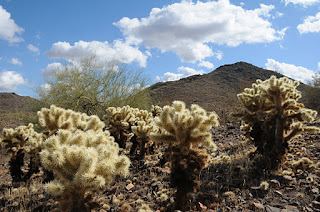
Cholla cactuses along Dixie Loop
View from Western Vista summit
Located just a few clicks east of I-17 on the fringes of a residential area, this pristine island of desert features panoramic views of the entire Valley.  You'll see the  Hieroglyphic Mountains to the west, Cave Creek and New River  Mountains to the north, and Camelback and Piestewa Peaks to the south.  Luminescent  “jumping” cholla, sweet-smelling creosote and arroyas choaked with acid-green Palo verde trees decorate  the paths, providing ample nesting places for the resident Gila woodpeckers, Gambel quails, lizards and red-tail hawks.
So before you join the ranks of the “poo-pooing-perceived-powerless”, get off the couch, hit the trail and prepare to be awestruck. Who knows, you (or somebody you know) may also be inspired to become a registered voter.


LENGTHS:
Dixie Mountain Loop: 4.62 miles, including the Hawks Nest access trail.  OR 5.74 miles including both optional summit spurs.
Hawks Nest: 0.40 mile one way
Dixie Mountain Summit: 0.22 mile one way
Western Vista: 0.34 mile one way
RATING: easy-moderate
ELEVATION: 1,600' – 2,251'. Most of the loop trail hugs the 1,700' level. Western Vista spur: 2075', Dixie Mountain Summit: 2,251'
DOGS: dogs must be on leash and handlers must pack out poo
KID FRIENDLY: yes
BEST SEASON: October -April
FACILITIES: no restroom or water. plenty of parking, trail map sign, and there’s a special lot for horse trailers
HOURS: 6 a.m. to 7 p.m.
GETTING THERE:
Desert Vista Trailhead:
From Phoenix, go north on I-17 to Jomax exit.  Go 0.2 mile on Jomax to Norterra Parkway, turn left (north) and continue 1.2 miles to North Valley Parkway.  Turn right (south) and go 0.2 miles to Copperhead Trail.  Turn left and go just a few yards  to Melvern Trail.  Turn left on Melvern and go 0.1 mile  to Desert Vista Trail on the right .  Follow Desert Vista through a gate that leads to the trailhead..
INFO: City of Phoenix, Phoenix Sonoran Preserve
For general information: 602 262-7901
REGISTER TO VOTE: Maricopa County Elections Department, 602-506-1511.
MORE PHOTOS: