Find A Trail. Start Your Search Here:

Showing posts with label Wet Beaver Creek. Show all posts

Monday, January 4, 2021

White Mesa Trail

WHITE MESA TRAIL

 The view from the top of White Mesa

From the hyper popular Bell Trail, the imposing, vertical cliffs of White Mesa appear as an unsurmountable wall of stone. 

Hike goes to the top of the mesa:center horizon

Rising over 1,000 feet above one of the most heavily visited trails in Coconino National Forest 40 miles south of Flagstaff, the mesa is composed of colorful layers of red sandstone, buff-colored sediments and a cap of dark volcanic rock. 
Trail departs Bell Trail 1.7 mile from the trailhead

For those willing to make a detour from the water-centric trail that traces perennially flowing Wet Beaver Creek, the mesa’s secrets may be explored by way of the White Mesa Trail #86. 
The only tricky spot on the trail passes a rock jam


White Mesa towers over the Bell Trail

To get to it, first hike 1.7 miles on the Bell Trail.  Along this easy stretch that follows a wide dirt road that was once used to access mid-20th century ranch operations, keep an eye out for petroglyphs pecked into boulders on the north side of the road and foot paths that lead to icy pools in the creek.  The route enters Wet Beaver Creek Wilderness where the White Mesa trail departs the road at the head of Casner Canyon.  Leaving the leafy riparian corridor dominated by sycamore and cottonwood trees, the trail heads uphill on the western flanks of the canyon. While there are no switchbacks to ease the climb, the trail makes a constant but manageable ascent on a rocky single track.
The trail is clear and easy to follow

Like the Bell Trail, this one was originally used to move cattle to graze on high pastures.
  Its straight-up, edgy course passes through mostly shade less grasslands, cacti, rockfalls and the occasional mesquite tree clinging to steep slopes. 
A hiker nears the summit of White Mesa

The grassy summit of White Mesa

The trail is clear and easy-to-follow with only one spot where some hand-over-foot scrambling is required to get through a rock jam. 
A pastoral scene on White Mesa

At 3 miles from the trailhead, the path meets a barbed wire fence at the wilderness boundary that’s the official end of the trail. However, to enjoy the full experience of this hike, you’ll want to pass the gate (close it behind you) and continue on well-worn paths-of-use.
Part of the hike follows Wet Beaver Creek

The route tops out on a grassy, juniper-dotted plateau with excellent vistas all around.
 
Watch for petroglyphs on Bell Trail

Directly below, a dizzying gorge wraps around the mound of 5,131-foot Casner Butte.
The edge-hugging path climbs over 1,000 feet

To the northeast, the tip of 7,307-foot Apache Maid Mountain, Round Mountain (6,328 feet) and Table Mountain (6,197 stand out over rows of less prominent hills and mesas giving a birds-eye view of the wild landscape that surrounds this beloved Verde Valley recreation hub.
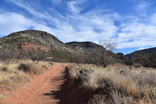
Casner Butte (left) stands out over Bell Trail

Vertical volcanic rock caps White Mesa

LENGTH:  6.5 miles round trip

RATING:  moderate

ELEVATION:  3,828 – 4,925 feet

GETTING THERE:

From Interstate 17 north of Camp Verde, take the Oak Creek/Sedona exit 298. Head left (east) at the bottom of the off ramp and go 2.2 miles on Forest Road 618 to the main Bell Trail parking lot.

There’s a restroom at the trailhead. Forest Road 618 is maintained dirt and suitable for all vehicles.  There are no fees.

INFO:

Coconino National Forest

https://www.fs.usda.gov/recarea/coconino/recarea/?recid=55434

Monday, March 11, 2019

Wickiup Mesa Trail System

Wickiup Mesa Trails
High desert vegetation on the Cedar Knoll Trail
Just a few miles north of Camp Verde, Wet Beaver Creek cuts a meandering course through  high desert plains and sparse mesas on its way to the Verde River. For thousands of years, the perennially-flowing stream has been the life blood for peoples who settled near its green corridor.  
Excellent signage on the Wickiup Mesa Trails
The communities of Rimrock and Montezuma Lake are the most recent to evolve around the reliable water source. The tiny towns are a quaint mix of ranch homes, antique shops, cafes and honey stands that sit at the hub of several important heritage sites off Interstate 17.
Montezuma Well (center far right) seen from the overlook.
Montezuma Well seen from the Well Vista trail.
The trail system crosses rugged washes.
Gordon's bladderpod bloom along the trails.
A scenic spot on the Cedar Knoll Trail.
Up until last year, out-of-town visitors had few reasons to do anything but drive through the creekside hamlets on their way to somewhere else, but a new system of hiking trails now tempt travelers to park and stay awhile.
View of Wet Beaver Creek from Well Vista Overlook
The Wickiup Mesa Trail System, which sits on 700 acres of Coconino National Forest at the far southeast edge of the towns’ suburbs, is the result of years of effort by the Beaver Creek Trails Coalition--a volunteer organization dedicated to creating and sustaining trails in the Beaver Creek area-- in cooperation with the forest service. The tentacular network of 7 trails tethers the communities to Forest Road 618, filling a void between the splashy recreational hot spots in Wet Beaver Creek Wilderness (think: Bell Trail) and the Montezuma Castle-Montezuma Well National Monuments that preserve the legacy of the area’s ancient inhabitants.  
A classic high-desert scene on Sunset Loop.
MacDougal's biscuitroot bloom through June.
Situated in a landscape of striking contrasts, the trails meander in a place of sprawling flatlands, fractured cliffs and mountain vistas.  A strong undertow of earthiness guides visitors through spotty juniper-cedar forests, cactus-dotted grasslands, moist drainages and roughed-up washes on the highlands above the creek’s leafy riparian ecosystem. 
Mountain vistas surround the Wickiup Mesa Trails.

Anchoring the 6.5-mile network is the Sunset Loop Trail. A hike on this easy-rated circuit is a good way to get to know the area. From the roomy Forestglen trailhead, pass the gate and use the excellent map signs posted at every junction to navigate. Almost immediately, views of Sedona’s red rock formations and Flagstaff’s San Francisco Peaks appear on the northwest horizon.
Sunset Loop overlooks Wet Beaver Creek Wilderness
Hazy silhouettes of mountain peaks near Prescott and Jerome bolster the south and western skylines. 
View of snow-capped peaks seen from Sunset Loop.
Roughly halfway through the loop, the Well Vista Trail leads to a scenic ledge overlooking Montezuma Well and the floodplains of Wet Beaver Creek.  
A side trip to Montezuma Well complements the hike.
Although only the rim of the massive limestone sinkhole that holds over 15 million gallons of water is visible from the ledge, the site is only a short drive away on the road you came in on and makes for a fascinating post-hike side trip. Beyond the overlook, the loop swings west on a ridge overlooking the mesas and canyons of the wilderness area and V Bar V heritage site  along Forest Road 618---another point of interest just a short drive away. 
The rustic Forestglen trailhead.
 Whether hiked alone or in conjunction with visits to the nearby attractions, the Wickiup Mesa Trail System is a sweet addition to the Verde Valley-area recreational menu.
Yucca dot the grasslands on the Wickiup Mesa Trail system.
LENGTH: 6.5 miles total for 7 trails. (4 miles for Sunset Loop-Well Vista circuit)
RATING: easy to moderate
ELEVATION: 3646 – 3791 feet (for the loop)
GETTING THERE:
From Interstate 17 north of Camp Verde, take the McGuireville exit 293 and veer east (right) onto Beaver Creek Road (County Road 77). Continue 1.8 miles and veer right onto Montezuma Ave. Go 1.3 miles to Cliffside Trail, turn left and follow the winding road 0.9 mile to Geronimo Road, turn right and drive 0.4 mile to Forestglen Road. Turn right and continue 0.3 mile to the trailhead at the intersection of Redrock Road. No fees or facilities.
Beaver Creek Trails Coalition
V Bar V Heritage Site
Montezuma Castle-Montezuma Well


Thursday, September 1, 2016

V BAR V HERITAGE SITE

V Bar V Heritage Site
Petroglyphs at V Bar V 
After surviving centuries of exposure to Arizona's extreme climate, the petroglyphs at V Bar V Heritage Site almost succumbed to cow butts. There's an air of mysticism about the tiny alcove that bears the etchings of the Southern Sinagua people who lived in the area from A.D. 1150 to around 1400. Shaded by sandstone bluffs near the banks of Wet Beaver Creek east of Sedona, site is wrapped in a strip of viney, deciduous forest that insulates it from the surrounding high desert heat. It's no wonder the cows found it too.
Ranch relics along the trail
Beautiful mysteries in the rock
Seeking water and a shady spot to wallow away the days, grazing cattle from ranch operations that occupied the property during the 20th century would congregate at the cliffs, rubbing their hides against the ancient embellishments. Luckily, a rancher who understood the historical value of the rock art fenced off the site before the cows could scour away the etchings. Today, a swath of bovine-butt-burnished sandstone is still visible on the panels. Since this initial save, the preservation baton has been passed on to Coconino National Forest, Verde Valley Archeological Society, Friends of the Forest and the Arizona Natural History Society.
With more than 1000 documented petroglyphs, the site is the most concentrated and best preserved in the Verde Valley. Volunteers conduct on-site talks describing archeological findings and theories about the meaning and purposes of the symbols. Without this guidance, you might not notice that much of the art swirls around a sophisticated solar calendar. Guides point out what are believed to be solstice markers, planting calendar, records of celestial events and a map of the Verde River tapped into russet stone walls.
Creekside trail to the archeological site

Although we'll never know for sure what the incised images of animals, humans and geometric forms represent, it's fun to toss around your own creative hypotheses. Perhaps the beautifully symmetrical designs record dance steps, songs, shamanistic messages, family names or the doodling of hunters waiting for a deer to wander into range. Regardless of our guesswork, this was, and is an important place worthy our continual protection.
Volunteer guides enlighten visitors
LENGTH: 1 mile round trip
RATING: easy
ELEVATION: 3800'
GETTING THERE:
From Interstate 17 north of Camp Verde, take the Sedona-Oak Creek exit 298. Turn right at the bottom of the offramp and continue 2.8 miles to the entrance on the right. The site is open Friday through Monday 9:30 a.m. to 3 p.m. Closed Thanksgiving and Christmas. There are restrooms, picnic tables and a gift shop at the visitor center. A Red Rock Pass is required and may be purchased on site.
INFO & MAP: Coconino National Forest
RED ROCK PASS PROGRAM:

Wednesday, March 27, 2013

BELL TRAIL


BELL TRAIL
Wet Beaver Creek Wilderness
Wet Beaver Creek
The weather is heating up and soon we'll be heading to higher elevations in search of cool summer trekking. But right now, with temperatures hovering between warm and torrid, a visit to the high desert, swimming holes of Wet Beaver Creek is just the ticket for a refreshing day trip.   Few things are more invigorating on a sweltering day than a dip in a canyon stream. The Bell Trail #13 leads to one of the most beloved of all Arizona swimming holes—“the crack”. Tucked into a slender slot canyon where the chilly, spring-fed waters of Wet Beaver Creek flow year-round, this natural water park attracts droves of visitors.
The hike in is completely exposed to the sun, but never strays far from the creek with its lush riparian vegetation, numerous shallow pools and slick-rock water chutes. At the 3.25-mile point, the trail comes to a junction near Bell Crossing. Although the official route veers right, crosses the creek and climbs 1,200 feet to the top of the Mogollon Rim, those in search of plunge must hang a left instead and head for the red cliffs that form “the 
Rapids at Bell Crossing
crack”.

LENGTH: 6.5 miles roundtrip
RATING: moderate
ELEVATION: 3,880 – 3,980 feet
FACILITIES: restroom, nearby camping
DRIVING DISTANCE FROM PHOENIX: 115 miles
GETTING THERE:
From Phoenix, travel north on I-17 to exit 298. Go left (east) onto Beaver Creek Road (Forest Road 618) and continue 2.1 miles to the trailhead on
The Crack
the left.
INFORMATION: Red Rock Ranger District, Coconino National Forest, 928-203-7500, 

Thursday, January 31, 2013

Winter water clears the weir


WEIR TRAIL
Wet Beaver Creek Wilderness
Wet Beaver Creek near the weir

Near the weir
Finding “Bell Trail Virgins” isn’t easy.  Ranking high on the flagpole of fabulous Arizona hikes, Bell Trail is a destination most seasoned trekkers have visited at least once.  "Virgins" are those who have somehow managed to miss this blaring giant of a trail.  As for me, I’ve hiked this trail so many times it cycles in my brain like an viral video over, and over, and over……again.  Yes, the beauty, the water, the juxtaposition of cactus-studded savannah with lush, streamside greenery and, oh yeah---those pool-wallowing naked people.  Never again.  I said.  Until a friend emailed me about introducing not one, but TWO “Bell Trail Virgins” to this iconic, Red Rock Country route, the anticipation of seeing the smiles on their faces was just too good to pass up so, I was on board, but with a twist that included a wander down the Weir Trail which branches off the Bell at the 2.5-mile point.  For years, I’ve had a hankering to explore this short diversion, however, since it seems to be a favorite haunt of the aforementioned skin-clad hordes, I never got around to it.  Alas, our hike this week amidst residual snow and 40-degree temperatures meant the weir was clear.  Turns out, the Weir Trail is a beautiful little trek that winds gently down to a concrete dam (the weir) and a gauging station that transmits flow data to---I don’t know.  Densely wooded with cottonwoods, sycamores, alders and willows, the creek near the weir is bolstered by rusty sandstone cliffs and sandy beaches.  One advantage of visiting this trail in winter is that the creek flows fast and wild, more so than in springtime when snowmelt wanes, the water warms and the nudists return to their wallows.
Water rages over the weir: Jan. 31, 2013

LENGTH:  7 miles roundtrip
RATING: moderate
ELEVATION:  3860' - 3760'
FACILITIES: restroom
FEES: none.  A Red Rock Pass is NOT required here.
BEST SEASON: October - April

GETTING THERE:
From Phoenix, travel north on I17 to exit 298 for Sedona-Oak Creek.  At the bottom of the off ramp, turn right onto FR618 and continue 2.2 miles to FR 656 where there's a sign for “Beaver Creek Work Station” and the trailhead.  Turn left and go 0.1 mile to the Bell Trail parking lot. 
HIKE DIRECTIONS:  Follow Bell Trail 2.75 miles (past the White Mesa and Apache Maid junctions) to a large metal sign at the wilderness boundary. The Weir Trail #85 veers right while the Bell Trail continues straight ahead.  Follow Weir Trail .75 mile to its end, and then backtrack.

INFO: Red Rock Ranger District, Coconino National Forest, 928-203-2900

MORE PHOTOS: