Find A Trail. Start Your Search Here:

Thursday, July 26, 2012

Hike and swim at Red Rock Crossing


RED ROCK CROSSING
Crescent Moon Ranch, Sedona
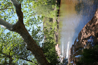
A gigantic sycamore shades Oak Creek

Ancient spirits are rumored to inhabit the rusty-red landforms that soar above this enchanting, cottonwood and sycamore-shaded bend in Oak Creek Canyon. That’s because, in addition to being one of the most photographed locations in the world, Red Rock Crossing also is one of Sedona’s vortex sites—places on earth noted for their high spiritual energy. The area’s beauty and cooling waters attract religious pilgrims, tourists, and those who just want to enjoy majestic views and cool breezes along the creek. Many of the trails in the park are stroller and wheelchair-accessible while shaded ramadas, restrooms, access to swimming holes, water chutes and fly fishing combine for a memorable, family-friendly daytrip.

Himalaya-Berry
PLANT PROFILE:
Himalaya-Berry (Arizona blackberry)
Rubus procerus
Habitat: introduced species found mainly in Oak Creek Canyon and Grand Canyon NP
Elevation: 4,000 – 6,000 feet
Blooms: June
Berries: summer

Lush riparian greenery flanks the creekside trail
HIGHLIGHTS: kid-friendly, water play, some barrier-free trails, picnic armadas, world-famous views
LENGTH: 2 miles roundtrip (for the unpaved creek walk)
ELEVATION: 4,000 feet
RATING: easy
DOGS: dogs must stay on leash and out of the water
DISTANCE FROM PHOENIX: 125 miles one way
GETTING THERE:
Drive west from Sedona on AZ 89A to Upper Red Rock Loop Road (Forest Road 216) and follow the signs to Red Rock Crossing.
FEES: $10 daily fee per vehicle
INFORMATION: Red Rock Ranger District (928) 282-4119, http://www.fs.fed.us/r3/coconino/recreation/red_rock/crescentmoon-picnic.shtml

June 26th plane crash closes 2 Sedona trails

Airport Loop and Table Top Trails in Sedona are temporarily closed due to an airplane crash that occurred this morning.  Please contact the Red Rock Ranger District or the Coconino National Forest web site before planning a hike here.
http://www.cnn.com/2012/07/26/us/arizona-plane-crash/index.html?hpt=hp_t2
Red Rock Ranger District: 928-203-7500
http://www.fs.usda.gov/recarea/coconino/recreation/hiking/recarea/?recid=71905&actid=50

Tuesday, July 24, 2012

Your guide to summer WATER recreation


PHOENIX MAGAZINE AUGUST 2012 ISSUE

Hi Hikers (anglers, boaters, tubers...), pick up a copy of the August PHOENIX magazine for my story about AZ summer water recreation.  You'll find 71 ideas for hiking, boating, fishing, camping, kayaking and just about anything (gold panning, anyone?) else pertaining to outdoor water recreation. 


ON SALE AUGUST 26, 2012
Here’s where you can find PHOENIX magazine: Safeway, Fry’s Marketplace, Wal-Mart, Costco, Sam’s Club, Sunflower Markets, Sprouts, Borders, Barnes & Noble, CVS, Walgreens, Sky Harbor Airport, Albertson’s, Fresh & Easy, Lowe’s, Home Depot, Target, Whole Foods, Basha’s, A.J.’s, La Grande Orange, The Kitchen, Area hospital gift shops WEB SITE: http://www.phoenixmag.com/ ORDER BY PHONE: 480-664-3960


Sunday, July 22, 2012

Descend a rocky road to East Clear Creek


MACK’S CROSSING
Coconino National Forest

Since it was abandoned in the 1940s, the old road leading to Mack’s Crossing has disintegrated into a precipitous ledge overlooking the gaping gorge carved by
East Clear Creek.
Even though the rough conditions don’t deter brave souls in fishing-gear-laden ATVs from careening down the serpentine route-- hiking at a leisurely pace is the best way to savor the  epic beauty of this dramatic canyon.
The downhill trek to the creek begins on the sunny edge of the Mogollon Rim, passing fossiliferous limestone outcroppings and a stand of elegant Arizona walnut trees before rounding a bend where grand views of the waterway 600 feet below grab the spotlight.
East Clear Creek
Near the creek, thickets of wild roses, alders, and exotic wildflowers color the landscape and provide handy excuses to stop and take in the sights.  Although the official trail ends where the road meets the sandy shore of the shallow stream, opportunities for wading, swimming and fishing abound both up and downstream.

Antelope Horns
PLANT PROFILE:
Antelope Horns
Asclepias asperula
Habitat:  woodland clearings and open areas
Elevation: 3,000 – 9,000 feet
Blooms: April-August


LENGTH:  4 miles (on trail)
ELEVATION: 6,250 – 6,860 feet
RATING: moderate

DISTANCE FROM PHOENIX:  165 mils one-way
GETTING THERE:
From the junction of AZ 89 and AZ 260 in Payson, go north on 89 past Clint’s Well to milepost 304.5 and turn right onto Enchanted Lane (Forest Road 319).  Continue .2 miles to Green Ridge Dr., hang a right and go .5 miles to Juniper Dr. From here, turn right and go a short distance to Cedar Dr. and follow it to the “primitive road 137” sign.  Park along the road—do not block private driveways.

INFORMATION: refer to the Coconino National Forest map
MORE PHOTOS: