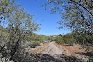
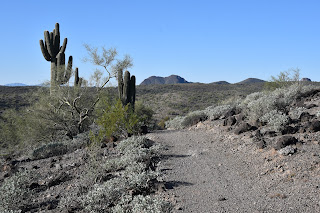
BEARDSLEY
TRAILBeardsley Trail crosses the Agua Fria River
The fusion
of cholla-encrusted foothills and desert waterways is the foundational flavor
of the Beardsley Trail. Running through undulating
terrain on the southwest edge of Lake Pleasant, the 4.4-mile route rolls out in
an unrelenting string of ups-and-downs. Beardsley Trail is part of the 315-mile Maricopa Trail
The trail, which is also part of the 315-mile, Valley-circling Maricopa Trail, provides a walking tour of a riffled
landscape carved by the Agua Fria River and Morgan City Wash that rush sporadically,
and trickle regularly through the arid foothills below the New Waddell Dam that
contains the lake.
The hike
starts roughly 2 miles south of the lake at the end of Beardsley CSR Road off
the Carefree Highway (State Route 74) about 30 miles north of Phoenix.Cottonwoods in Morgan City Wash seen from Beardsley Trail Cholla glow in morning light on Beardsley Trail
After
passing the trailhead gate, the hike makes its first of many downhill dips--this
one into a leafy riparian corridor where the Agua Fria River and Morgan City
Wash merge. The short walk under
cottonwoods, mesquite and invasive salt cedar trees is outfitted with a pair of
foot bridges where water periodically flows over the trail. Brittlebush shrubs are plentiful along the route
Lush with greenery
and laced with the herbaceous scent of triangle-leaf bursage, the watery
segment quickly morphs from jungle-like to a more desert standard creosote-and-cacti
ecozone. The trail follows South Park
Road for a few yards before beginning its twisted north-bound journey through saguaro
cluttered slopes, tight bends and long, swooping stretches that hang over deep
folds in the landscape. Mountain vista from the trail high points
New Waddell Dam seen from Beardsley Trail
Throughout
much of the hike, a ribbon of cottonwoods and willows visible in the canyons
below the trail, betray the course of Morgan City Wash. Water lingers in the Agua Fria River
The brilliant linear oasis, which shows off in
shades of gold in autumn, is fed by a high water table and is home to rare
native fish, myriad dragonflies, abundant birds, amphibians, and critters including
racoons, foxes, deer and javelinas. Desert tobacco blooms year-round in moist areas
About midway
through the hike, the trail begins hitting its highest elevations. Needleleaf Dogweed adds pops of color to the trail
At just over
1,700 feet in elevation, the views expand with glimpses of the Bradshaw and
Cave Creek Mountains as well as looks at the glassy, cove-fringed reservoir and
its smattering of islands before the trail ends near the Desert Tortoise Campground.
LENGTH: 8.8 miles round trip
RATING: moderate
ELEVATION: 1,459 – 1,735 feet (620 feet of accumulated elevation change)
GETTING THERE:
Agua Fria Trailhead, Lake Pleasant Regional Park.
From Interstate 17 in Phoenix, take the State Route 74 (Carefree Highway) exit 223 and go 8.8 mile west on SR 74 to the turn off for the Beardsley CSR access road. Turn right and continue a short distance to the parking area.
FEE: $7 daily fee per vehicle. $2 daily fee for walk/bike in with no vehicle parking in the area.
INFO & MAPS:
Lake Pleasant Regional Park
https://www.maricopacountyparks.net/assets/1/6/lake-pleasant-8x111.pdf


