Find A Trail. Start Your Search Here:

Thursday, September 22, 2022

Ranch Loop

RANCH LOOP

Bear Mountain in Sedona seen from FR 761B

Sedona’s back roads provide pleasantly uncrowded alternatives to traditional hiking trails. 

Wildlife water hole along FR 761B

Open to motorized use, the Ranch Loop circuit west of town is also a great place to camp and walk in the high desert. 

Route briefly parallels the Lime Kiln Trail

Situated between the iconic red rock formations of Sedona and the broad skyline of the Bradshaw Mountains, Ranch Loop uses Forest Roads 525, 761B, 761, 525A, and 525C for a striking hike through rangeland and creek courses. While the route sounds complicated on paper, it’s not difficult to follow.
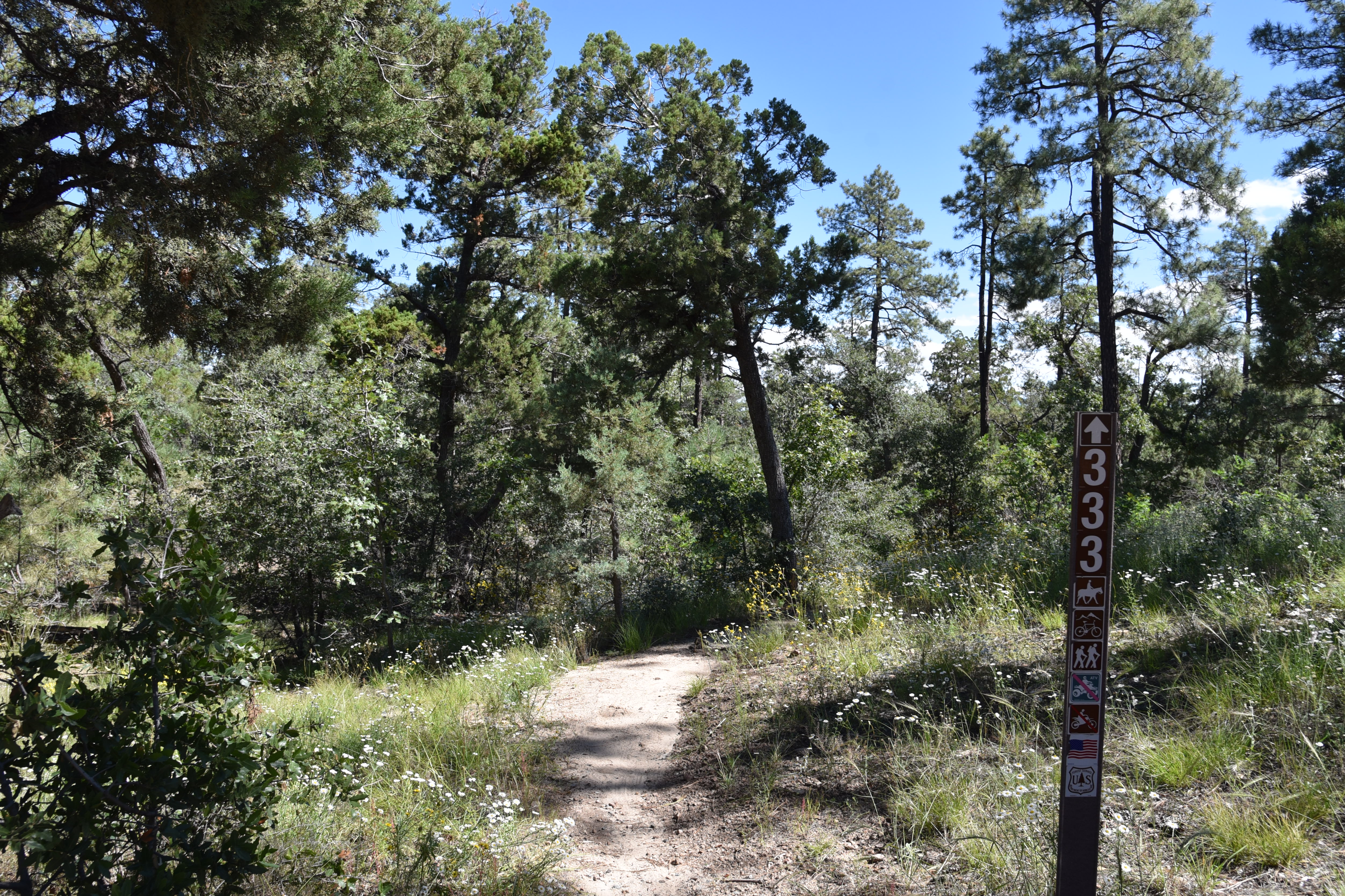
Ranch Loop is easy to follow

Bright sign posts mark the way throughout. Beginning at the signed juncture of FR 525 and 761B, the route winds through sun baked Coconino National Forest grasslands with mountain views all around.
Cottonwoods & willows line Coffee Creek

 
On the northwest horizon, the hulking silhouette  of Bear Mountain rises over golden fields while the western front is  filled with the hazy forms of Mingus and Woodchute mountains in Prescott National Forest.  In the south, the elongated slope of House Mountain volcano paint a haunting backdrop.
Great mountain vistas seen throughout the hike

Mostly treeless and exposed to mountain crosswinds, the route changes its colors where it passes by a wildlife water hole and crosses the courses of Spring and Cherry Creeks. The pebble-strewn channels and the pond which is contained by an earthen dam, are cluttered with thick stands of willows, cottonwoods and mesquite trees.  Where the route briefly parallels the cairn-marked Lime Kiln Trail, a smattering of roadside ranch relics begin popping up. 
Spring Creek bisects the route

Rustic fencing, barbed wire and a metal tub stand among tangles of cactus and cat claw. 
Cattle guard at the base of a limestone knoll

House Mountain volcano viewed from the trail

The forest service describes the Ranch Loop as a 6.5 mile trip, but that distance doesn’t include the 2.5-mile leg on FR 525c/525 needed to close up the loop.

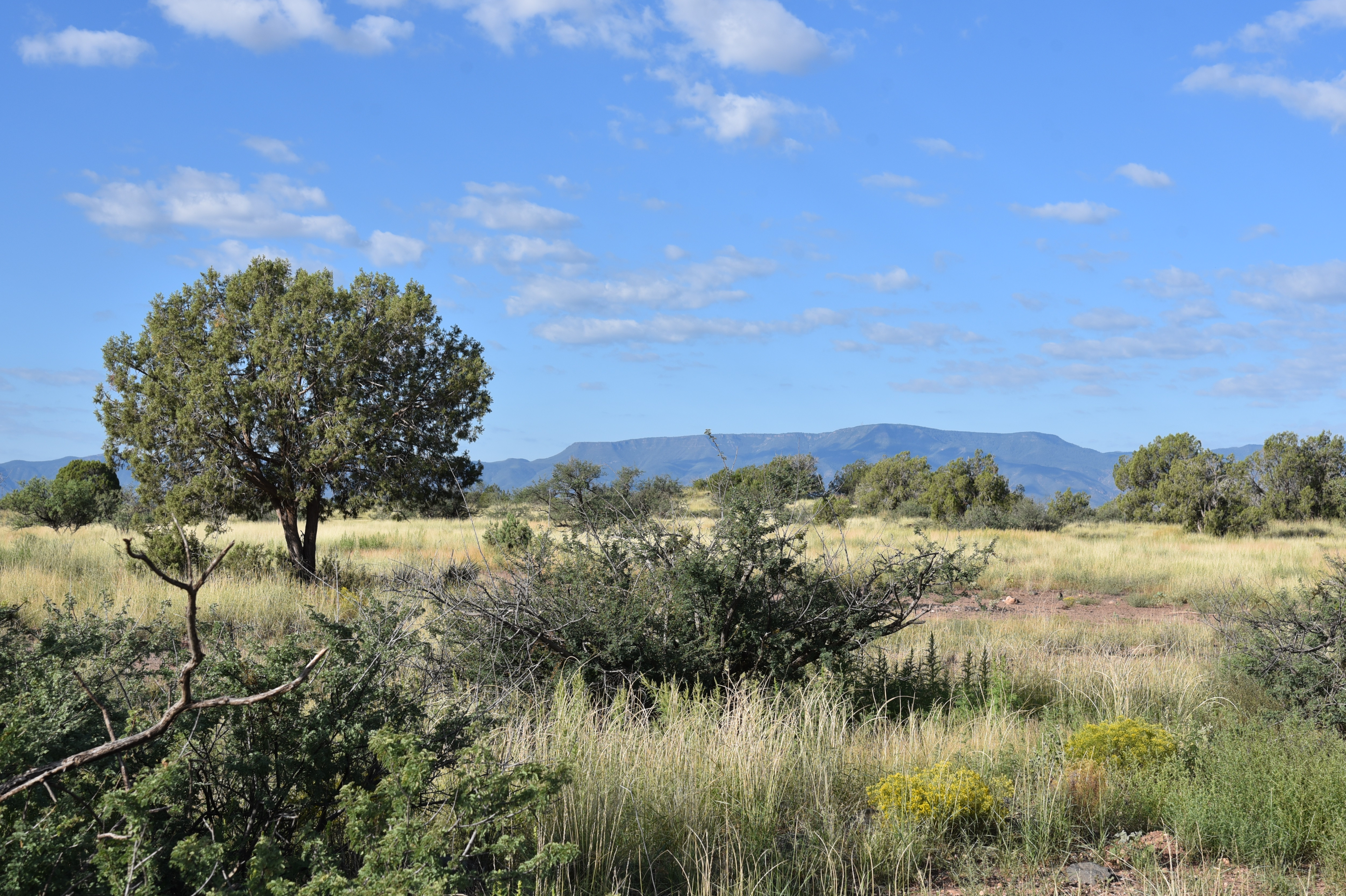
Mingus Mountain rises over juniper-dotted plains

 
Rock spires of Sedona on the horizon

The tie-up leg comes just beyond the Windmill Ranch site (private property) where the route meets Forest Road 525C, where hikers must head right (east), hike a half-mile to FR 525, then turn right again for the final 2-mile walk back to the trailhead.
An earthen dam contains this water hole

Pronghorn bolt across an open pasture

LENGTH: 9 miles

RATING: moderate

ELEVATION:  3,768 – 4,100 feet

GETTING THERE:

From the State Route 179/89A traffic circle in uptown Sedona, go 9.7 miles west (left toward Cottonwood) on SR89A to Forest Road 525 (Loy Butte Road) on the right. Turn onto FR525 and go 0.5-mile to the Ranch Loop sign at Forest Road 761E.  There are two designated parking areas before the Ranch loop sign. There are many new dispersed camping sites in the area. Please park, stage and camp only in these designated areas.

INFO & MAP:

https://www.fs.usda.gov/recarea/coconino/recarea/?recid=82742

Monday, September 19, 2022

Honeybucket Loop

HONEYBUCKET LOOP

Prescott National Forest.

View of Granite Mountain from Honeybucket trail

At its core, the Honeybucket Loop is a mashup of old forest roads and adopted social paths tied into a hiking trail.

The loop is well signed throughout its 4.6-mile course

 
At its heart, its arguably one of the prettiest little strolls in Prescott National Forest. The route delivers generous servings of mountain vistas, shady forests, interesting geology and late summer wildflowers. It’s a true sweet spot among the dozens of trails that weave through the woodlands around Prescott’s Thumb Butte.
Western dayflowers bloom August - September

The loop is a perennial offering on the Highlands Center for Natural History annual Hiking Spree event. The Hiking Spree challenges hikers to complete 8 out of 10 selected treks over the course of 3 months for a chance to be entered into a prize raffle and purchase a commemorative medallion upon completion.

Thumb Butte peeks through pines on Honeybucket

From a slightly out-there trailhead off Thumb Butte Loop Road just 6 miles west of Downtown Prescott, the circuit begins with a 1-mile walk on the Honeybucket trail #333. 

Western yarrow blooms June - September

Weaving among granite outcroppings and stands of ponderosa pines, this warmup section is ablaze in late summer wildflower color.
A boulder passage on Honeybucket trail

Fleabane, goldenrod, tansyleaf aster, western dayflowers, brickellbush, yarrow, thistle and groundsel add sprinkles of yellow, blue, purple and white in sunny spots. 
Prescott Circle Trail Connector has big views

First peeks at iconic Granite Mountain (7,295 feet) emerge at about the half-mile point where the trail bends northward picking its way through thick scrub and massive alligator juniper trees. The loop portion of the circuit departs from the Thumb Butte Bypass Trail #326 junction. 
View of Granite Mountain from Thumb Butte Bypass

Alligator juniper on the Thumb Butte Bypass

From the junction, continue hiking on Trail #333 as it makes a mild descent toward Butte Creek through a more open terrain with see-forever views of the Sierra Prieta mountain range.
Fleabane decorate the loop May - October

 
Trailhead is a dirt pull off on Thumb Butte Loop Road

The trail traverses green gullies and drainages before meeting up with the Prescott Circle Trail Connector Trail #322.  Go left at the junction and follow this 0.7-mile segment while watching for fleeting glimpses of Thumb Butte ( 6,514 feet) and the Williamson Valley that peer out between breaks in tree cover.  The last arc of the loop starts at a major intersection where the circuit heads left on the Thumb Butte Bypass Trail #326. 
The circuit crosses ravines and drainages

Arizona thistle blooms May - October

This 0.6-mile segment follows an old dirt two-track that makes a gradual climb beneath a pine-oak-juniper canopy with fields of hip-high grasses tangled with blooming shrubs lapping at the ankles.  More peeks at Granite Mountain and Thumb Butte punctuate the skyline before the trail reconnects with the Honeybucket trail for a rewind back to the trailhead. While it’s short and just moderate in its physical demands, the Honeybucket loop never scrimps on visual richness, making it a fine choice for appreciating the flora and mountain terrain of Prescott forests.
Wildflowers blanket a section of Honeybucket trail

LENGTH: 4.6 mile loop

RATING: moderate

ELEVATION: 6,094 – 6,400 feet (703 feet of accumulated elevation change)

GETTING THERE:

From Courthouse Plaza in downtown Prescott, go west on Gurley Street , which turns into Thumb Butte Road.  Continue 5.2 miles, passing the Thumb Butte and White Rock trailheads, to Thumb Butte Loop Road (Forest Road 373) on the left. Follow FR 373 for 1.6 miles to the turn off for Forest Road 51 on the left where there’s a dirt parking apron at a Trail 333 sign.

Thumb Butte Loop Road is washboard rough with some potholes but is passible by most carefully-driven vehicles. The road is not maintained in winter.

INFO:

https://highlandscenter.org/hiking-spree/

https://highlandscenter.org/wp-content/uploads/Honeybucket.pdf