Find A Trail. Start Your Search Here:

Showing posts with label Spur Cross Ranch. Show all posts

Tuesday, May 23, 2023

The Arizona Whistle Initiative

THE ARIZONA  WHISTLE INITIATIVE

Schasteen, Finn, Parker and Gilleland

 “We didn’t expect things to go wrong,” says Thomas Finn about an ill-fated hike up to Skull Mesa in Tonto National Forest. “We were just friends out for fun and fellowship. We made a few mistakes. The trail was confusing, washes looked like trail and we got off course. We discussed turning around but decided to push on. It took too long to get to the top and by then it was over 100 degrees. That’s when we ran into problems with water and heat.”

While the missteps Finn described about the Labor Day 2022 hike that ended tragically with the death of his friend and hiking companion Dr. Evan Dishion are not unusual, they are almost always preventable.

Sign commemorating the lost hikers at Spur Cross

Rainer Schasteen, was also on the trek that included young, fit, experienced hikers.

“We had a false sense of security because we were in a group. I let down my guard a bit,” Schasteen said. “I’ve learned--you’re responsible for yourself.  That’s why I’m now more prepared on hikes. I bring extra water, food, enough to share if needed.” Schasteen emphasizes that search and rescue crews will not be mad at you for seeking assistance and you shouldn’t hesitate if you feel at risk. “If you think it’s a good idea to call for help; do it,” he stated. “I was eventually able to get cell reception (on the Skull Mesa hike) and we were rescued by helicopter. But it was too late for Dr. Dishion.  One or two more water bottles could have made a difference.”

AZFH911 volunteers show their whistles

 Dr. Evan Dishion was one of three recent hiker deaths in the Cave Creek area. Hikers Kathleen Patterson and Austin Peck also succumbed to heat, disorientation, and dehydration. 

 That’s when Sunny Parker, Founder and President of Arizona Foothills 911 decided it was time to up her game.  Parker set up the 501c nonprofit organization after an answered prayer. “My son had been diagnosed with a serious medical condition and was given little chance for survival,” Parker shared. “I fell to my knees and promised that if his life was spared, I’d spend the rest of my life making a difference by giving back to my community.”  Her son recovered, just as a string of wildfires that rattled her town of Cave Creek got her thinking.  “I asked myself, what can our community do to be better prepared and quicker to respond.”  That’s what inspired her to create Arizona Foothills 911 to inform and rally communities around Cave Creek and the North Valley in emergency situations.  ‘Neighbors helping neighbors because it’s the right thing to do’, is the organization’s motto.  During wildfires, floods or other natural disasters, the community-driven organization supports first responders, assists with pet and livestock evacuations, and keeps residents up to date about how to find or offer help.  The mission also extends to preparedness education and rounding up volunteers for search and rescue operations.  “We were the ones who found Kathleen Patterson. It was a very sad outcome, but we are thankful we were able to bring closure for her family.”  But Parker knew that she could do more to help prevent hiking tragedies.

Booths at the April 22, 2023 event


“I thought, this can’t continue to happen. What can we have done differently?”  After speaking with friends and relatives of the victims and first responders, Parker learned that lack of preparedness, unforeseen mishaps and technology fails often contributed to deadly outcomes.  Two solutions seemed obvious. First, educate hikers about how to be prepared for emergencies, and second--give them a big, loud whistle. Thus, the birth of Arizona Foothills 911’s The Arizona Whistle Initiative hit the ground running. 

“If you depend too much on technology (like cell phones and trail apps) it will probably fail when you need it most,” says Shawn Gilleland, Arizona Foothills 911 Public Information Officer.  While carrying expensive personal locator beacons and satellite messengers on hikes can save lives in emergency situations, so can simple, low-tech tools and common sense. “Take a whistle and always let somebody know where you’re going and when you expect to return," Gilleland said. "Share a pre-hike selfie with friends showing what you are wearing." Selfies can help locate you if you get lost because drone technology can search for specific colors.  Gilleland was on site at an April 2023 Whistle Initiative event at Spur Cross Ranch Conservation Area in Cave Creek to promote hiking safety and give away free trail maps and emergency whistles. The theme of the event focused on the facts that one can never be too prepared and even the most physically fit and experienced hikers can get into trouble on the trails.

Whistle giveaways are funded by donations

“It’s always a good idea to have a back-up plan,” Parker says. “A whistle worn where you can easily reach it (not kept in your pack) can save your life when batteries die or you’re out of cell phone range.” The whistle giveaways are funded by donations. But finding just the right whistle to hand out was a trial-and-error endeavor for Parker. “I finally settled on a storm whistle that reaches 120 decibels. I had the manufacturer overnight me a sample and tested it for range and durability. It’s tough and you can hear it for miles.”

The whistle is just one part of the well-prepared hiker kit.  “Know your abilities and let somebody know your plans,” says Gilleland.  “Temperatures and trail conditions can change rapidly so plan accordingly. Wear proper clothing, understand your route, bring your whistle, and carry more water than you think you’ll need.”

A low-tech whistle can save lives in emergencies

The Whistle Initiative events honor the memories of Patterson, Peck and Dishion, who Parker says makes the mission of Arizona Foothills 911 stronger, better, and even more committed. “We plan to hold more events throughout the year,” Parker says.“Check the organization’s website or Facebook group for updates.”

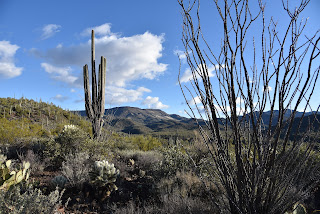
Skull Mesa viewed from Spur Cross Ranch Conservation Area

Of all the great hiking advice and information shared at the Spur Cross event, there’s one takeaway that resonates loudly.

 “If you ever think it’s a good idea to turn around, take that opportunity,” Thomas Finn advises. “Trust your gut.”


AZ FOOTHILLS 911

https://azfoothills911.org/

Facebook.com/groups/AZFH911

Friday, January 14, 2022

Tortuga-Spur Cross Loop

TORTUGA-SPUR CROSS LOOP

The pachyderm profile of Elephant Mountain


A quick loop hike in Spur Cross Ranch Conservation Area north of the town of Cave Creek  yields a heart-stirring trip through canyons, saguaro-fleeced slopes and a rare desert waterway, all backed with outstanding mountain views.

Saguaros cling to slopes below the CaveCreek Mountains

 
The short, but steadily challenging hike ties together two of the Maricopa County Regional Park’s trails into one stunningly tour of Sonoran Desert diversity.

From the trailhead, begin by hiking northwest (go right and downhill) on the Spur Cross Trail which is also part of the Valley-circling Maricopa Trail.  In less than a half-mile, the trail crosses Cave Creek.

Skull Mesa viewed from the Tortuga Trail

 
Fed by storms and snowmelt, water runs sporadically through the rocky channel and is usually at its height during the winter and spring months.  A few yards past the creek crossing, continue north on Spur Cross from the Metate trail junction keeping an eye out for the foundations of the defunct Spur Cross dude ranch crumbling among cholla and creosote shrubs.
Sun-lit saguaros glow on the Tortuga trail

Over the next 0.6-mile, the route climbs easily, opening views of the creek gorge below and the flat-topped tableland of Skull Mesa and Sugarloaf Mountain to the northeast. One mile in, pick up the Tortuga Trail  which signals the beginning of a steady ascent on a degraded dirt track that hangs on the cusp of a ravine flush with acres of saguaros, prickly pear, ocotillo and cholla that glow in thorny halos when backlight by the sun.

A crossing of Cave Creek comes early in the hike

The 1.1-mile uphill section is heralded by a sign warning of primitive conditions ahead. 
The as-advertised primitive trail

While the route is indeed rough, it’s not too difficult to follow. Soon, more vistas open to the south. 
Benches for viewing at the top of the loop

Look for Cave Creek classic, Black Mountain, the Cave Creek Mountains, the long profile of the McDowell Mountains and singular Pinnacle Peak on the horizon.
Sugarloaf Mountain (left) seen from Tortuga trail

 
This hike uses the Spur Cross & Tortuga trails

The circuit tops out at the Elephant Mountain trail junction where the best glimpses of the 3,926-foot massif’s pachyderm profile command attention.  A couple of benches overlooking the mark the spot where the Tortuga trail begins a 0.6-mile downhill trek toward the leafy cut of the Jewel of the Creek Preserve. 
Tortuga trail is rough but not hard to follow

To finish up this loop hike, head left at the Dragonfly trail junction and follow the Spur Cross trail as it switchbacks through a deep gully on its way back to the trailhead.

LENGTH: 5.3 miles

RATING: moderate

ELEVATION:  2,340 -2,615 feet

GETTING THERE:

44000 N. Spur Cross Road, Cave Creek

From Loop 101 in Phoenix, take Cave Creek Road north to Spur Cross Road (on the left just as you enter the downtown area) and go 4.5 miles north to the parking area. 

FEE: $3 per person daily fee. Bring exact change.

INFO:

https://www.maricopacountyparks.net/park-locator/spur-cross-ranch-conservation-area/


Wednesday, January 6, 2021

Get Hooked on the Maricopa Trail in 2021

SPUR CROSS-MARICOPA TRAIL

Beautiful back country on the Maricopa Trail

Sometimes, an addiction is a good thing.  Swapping a junk food obsession or a movie streaming fixation for a commitment to healthful foods and regular outdoor recreation are the kinds of addictions that improve quality of life.  Kicking bad habits isn’t easy, but hiking can help wean even the most devout triple-burger-with-the-works aficionados off the artery-hardening stuff.

The route crosses Cave Creek several times

That’s because, like eating potato chips, once you start, it’s difficult to stop.  And when you really get into it, you’ll be inspired to get fit to take on longer, more difficult treks.

A bird verifies Audubon Arizona important bird area

As with goals in general, it helps to have a plan. 

An old forest service sign on the Maricopa Trail

For Phoenix-area hikers, there’s a ready-made plan already in place. It’s called the Maricopa Trail.  The 315-mile route circumnavigates the Valley, connecting 10 county regional parks, urban centers, suburbs and national forest trails.  Outfitted with dozens of trailheads and community access points, the trail is easily accessed from anywhere in the Valley.  While the route is still expanding and improving, the main course is complete. There’s a beginning, middle and end which makes it a perfect choice for anybody who wants to earn the feeling of accomplishment that comes with completing a long-distance hike without committing to a months-long, non-stop journey. This one can be knocked off in approachable day hikes. 
The Maricopa Trail is 315-mile route

The route passes through a stony corridor

Of course, to get “addicted” it’s best to start with the juiciest segment.  While naming the “best” segment of the Maricopa Trail is purely subjective, the bit that goes from Spur Cross Ranch Conservation Area in Cave Creek to the Skull Mesa trailhead in Tonto National Forest is as fine a candidate as any.

Rich in biodiversity, ecozones, history and scenic beauty, this short, easy hike is a great way to sample and possibly get hooked on the Maricopa Trail. Begin by hiking north on the Spur Cross Trail, an old ranch road that has been incorporated into the trail.  Right from the start, the hike embodies a remote feel as it delves into hilly back country along the leafy corridor of Cave Creek.  The waterway fosters a healthy community of cottonwoods, sycamores and mesquite trees where many species of birds thrive in the area that has been named an important bird area by Audubon Arizona. 

An abandoned corral on the Maricopa Trail

The Tonto National Forest boundary

After a mild uphill walk and a couple of usually dry creek crossings, the trail enters Tonto National Forest. Staying close to the creek bed, the last mile passes through rocky corridors and cliffs cluttered with enormous saguaros. A few creek hops later, the path meets the Skull Mesa trailhead where a vintage wood sign displays a map and key mileage notes.
Huge saguaros grow along the route

From this point, the Maricopa Trail continues on through one of its most remote, rugged and mountainous sections.  But for an introductory outing, the wood sign makes for a good turnaround point that will inspire you to come back for more.
Elephant Mtn is a dominate feature on the hike

LENGTH:  4 miles roundtrip

RATING: easy

ELEVATION: 2,263 – 2,407 feet

GETTING THERE:

Spur Cross ranch Conservation Area:

37622 N Cave Creek Road, Cave Creek.

From Loop 101 in Phoenix, take Cave Creek Road north to Spur Cross Road (on the left just as you enter the downtown area) and go 4.5 miles north to the parking area. 

FEE: $3 per person daily fee. Bring exact change.

INFO:

https://www.maricopacountyparks.net/things-to-do/activity/maps/


Wednesday, January 2, 2019

Metate-Spur Cross Loop

Metate-Spur Cross Loop

Spur Cross Ranch Conservation Area
Snow-covered Skull Mesa reflects in Cave Creek
A wet autumn and snowy start to 2019 has boosted the benefits of hiking in Spur Cross Ranch Conservation Area in Cave Creek. 
Located just a few clicks north of Metro Phoenix, the 2,154-acre preserve has a surprisingly remote feel, a variety of hiking trails and a plethora of native vegetation that bursts with color when infused with a little extra precipitation.
Saguaros on the Metate Trail
The site, which is part of the Maricopa County parks system, bumps up against the foothills of Tonto National Forest where mountain-borne moisture flows through the area’s creeks, washes and drainages in year-round fits and spurts.
Tonto National Forest peaks seen from Spur Cross Trail
Spur Cross Trail
Sometimes the water arrives in a rage such as during spring snow melt season and monsoon rains, but mostly, the water that spills over the site’s hiking trails passes through in lazy trickles.  Getting around the water-centric park rarely means getting your feet wet, though. When water levels are high, the park ranger places plank bridges to assist crossings of Cave Creek.
Skull Mesa had a dusting of snow on January 1, 2019.
There's a bumper crop of wolf berries this season.
This year, ample moisture has coaxed out the greenery in a big way making a hike on the classic Metate-Spur Cross loop a botanical smorgasbord.  This short, moderate-rating hike is a perfect place to introduce winter visitors to area trails. Desert newbies will be awed by the medley of ecosystems and even locals will likely gain wider appreciation for the rare cocktail of vegetation living in this tiny plot. 
Although the preserve is the smallest of the ten county parks, it has the most diverse and profuse collection of Sonoran Desert plant species growing within its hilly space. 
Cave Creek flows across the Spur Cross Trail.
Recent storms have caused the desert to bloom.
To optimize the plant tour, begin hiking northwest (go left at the main trailhead kiosk) on the Spur Cross Trail.  The wide path makes a gradual descent among acres of brittlebush, jojoba and multiple species of cacti.  Most prominent here are wolfberry shrubs dripping in ripe orange fruits and a demonstration garden of agaves. 
Tiny Desert rock peas bloom along the trails.
In less than a half-mile, the ragged floodplain of Cave Creek hosts a riparian community of cottonwoods, willows and bunches of desert marigolds sprouting from the sandy corridor.  Cross the creek and head right on the Metate Trail for a walk through a massive saguaro forest and an enchanting mesquite bosque—a streamside gallery forest .
Wild cucumber vine on the Towhee Trail
Be sure to make a stop at the solar oasis, a wildlife water hole and an ancient Native American metate or grinding stone. A detour on the 0.2-mile Towhee Trail reveals a damp, birdy enclave entwined with wild cucumber vines and desert hackberry shrubs.
Plank bridges aid creek crossings.
After a second creek crossing, the trail heads up an embankment where ocotillo, cholla and prickly pear cacti dress the walk on a ridge high above the water while sweet views of New River and Skull Mesas stand as imposing bastions on the horizons.  
Brittlebush colors the Metate Trail
At the 1.3-mile point, head right on the Spur Cross Trail for the final leg back to the trailhead.  For a longer trek, consult the park website for maps or to join a ranger-led hike to the many hidden gems within the preserve.
Ancient Native American grinding stone (metate). 
New River Mesa seen from Metate Trail
LENGTH: 2.2 mile loop
RATING: moderate
ELEVATION: 2179 – 2250 feet
GETTING THERE:
Spur Cross ranch Conservation Area:
37622 N Cave Creek Road, Cave Creek.
From Loop 101 in Phoenix, take Cave Creek Road north to Spur Cross Road (on the left just as you enter the downtown area) and go 4.5 miles north to the parking area. 
FEE: $3 per person daily fee. Bring exact change for the self-serve kiosk.
INFO & MAPS:
-->

Sunday, June 18, 2017

Fruits of the Desert Guided Hikes

FRUITS OF THE DESERT GUIDED HIKES
Spur Cross Ranch Conservation Area, Cave Creek
Saguaro fruits ripen in early July
The Rim is on fire, Flagstaff is covered in smoke, there's a blaze on Mt.Graham and who knows what other wildfires will break out and cause closures to our high-country hiking trails over the next few weeks?  Of course, we must first be concerned with the safety of firefighters and the communities surrounding the blazes. No matter how badly we Valley dwellers want to escape the heat and hike in the cool pines, we should stay out of the way. So, what? Give up hiking until the monsoon comes? No way. Instead, stay in town and take part in a hike that celebrates the annual ripening of saguaro fruits.  Ranger Kevin Smith at Spur Cross Ranch Conservation Area in Cave Creek has educational hikes planned for July 1, 7 and 8 that focus on the identification of wild foods hiding in plain sight along local trails.
Harvesting saguaro fruits
The treks start early and end before the heat of day kicks in. Ranger Smith leads participants into the hills above Cave Creek and demonstrates traditional techniques for harvesting cactus fruits and other desert delicacies.  And, yes, the tour includes free tastes. So, why not learn a little bit about native Sonoran Desert edibles while getting your exercise and waiting for the rains to return. There’s no need to sign up, just show up promptly at 7 a.m.
Plus, this program is part of the “County Parks are Getting Wet 
‘n’ Wild this Summer” promotion. At the end of the hikes, there will be a drawing for a family four-pack (4 free tickets) to the Wet ‘n’ Wild Water Park.
Engelmann prickly pear fruit
LENGTH: variable but usually 2-3 miles
RATING: easy
ELEVATION: 2,200' - 2,800'
Tasty jojoba seeds

GETTING THERE:
From Loop 101 in north Phoenix, exit at Cave Creek Road and drive 15 miles north to Spur Cross Ranch Road, turn left and continue 4.2 miles to the parking lot on the left.
FEE: $3 per person permit required. Bring exact change for the self-serve pay station.
INFO:

Monday, August 15, 2016

HIKES THAT FEED THE BRAIN

RANGER LED EVENTS AT MARICOPA COUNTY REGIONAL PARKS
Ranger led hikes exercise both body and brain

It's common knowledge that there are many benefits associated with hiking. The exercise is good for your body and the rhythmic pounding of boots on earth and the sweat-fueled endorphin bliss afford a respite from the hassles of everyday life. Hiking just might be  the sweetest, most satisfying form of self-healing known to human kind. But the perks don't end with the physical gains. There are brain-fortifying learning opportunities right along the beaten path---if you know where to look for them.
A geologist describes Go John diorite
Abundant mental stimulation is within easy reach at Maricopa County Regional Parks. With close to town sites located near lakes, streams, mountains and sprawling valleys, the park system is sort of a microcosm of desert life. Although solo hiking within the parks provides a good workout with a side of grand scenery, it just skims the surface in terms of understanding the surrounding environment. To gain insight into the fascinating world through which park trails wander; participate in a ranger led hike or activity. Many of the system's twelve parks and recreation areas host events year-round including early morning and moonlight hikes to beat the summer heat.
Learn about ancient rock art

The menu of events range from kid-pleasing, silly fun (“Bug Theater", anyone?) to explorations of ancient cultural sites that enrich the nature experience for hikers of all ages. If you want to learn about edible desert plants, identify which creepy crawlies are poisonous, demystify complex geological specimens or are looking to meet new friends on a fitness hike, there's sure to be an upcoming event to suit your needs.
These hills hold many secrets...

Some ranger-led treks like "Hohokam Houses" which is offered regularly at Spur Cross Ranch Conservation Area in Cave Creek, venture into sensitive archeological areas that are normally off limits. To the unenlightened visitor, ancient cultural sites might look like random rock piles, but under the tutelage of a ranger, back stories culled from the rubble tickle the imagination. You'll learn about clues unearthed by excavations that hint at the community structures, survival strategies and life ways of long-gone inhabitants while gaining an appreciation for the preservation of heritage sites. And, oh yeah, there is one more hiking benefit specific to park programs---freebies. As an added incentive to get moving during the summer months, some events culminate with a drawing for a family 4-pack (4 tickets) to Wet 'n' Wild Water Park. Check the parks website for details.
UPCOMING PROGRAMS:

Monday, February 1, 2016

FAIRY DUSTER LOOP & MARIPOSA HILL TRAIL

TWO NEW TRAILS IN SPUR CROSS
Spur Cross Ranch Conservation Area, Cave Creek
Elephant Mountain stands out over fresh-cut Fairy Duster Loop

If you image the trails of Spur Cross Ranch Conservation Area as an ice cream sundae, Fairy Duster Loop and Mariposa Hill Trail are the whipped cream and cherry on the top. Neither trail requires much effort to hike, but they perfectly complement the area's more rough-hewn, difficult routes with soft footing and sweet views. Opened in January 2016, they offer short, pretty detours that connect with backbone route Spur Cross Trail (Maricopa Trail) to explore new territory on the site's east side.
Fairy Duster Loop traces the foothills above mesquite-cluttered Cottonwood Wash where profuse plant life makes the trek sort of like hiking through a mini botanical garden. In addition to the shrub for which it's named, plants you'll find along the flowing path include joboba, buckwheat, filaree, ratany, cholla cactus, brittle bush and dozens of wildflowers, making it a good choice for a springtime bloom snooping hike.
Mariposa Hill Trail is named for a delicate lily that decorates its flanks. This trail follows what used to be Old Cottonwood Canyon Road to a lookout point with big views of Cave Creek and the saguaro-studded mountains of Tonto National Forest.
These fresh-cut routes can be hiked alone or tagged on to old favorites like the Metate Trail, for a longer loop. Here's one trail mix option.
From the trailhead, hike 0.1-mile north on Spur Cross Trail (SX) , turn right onto Fairy Duster Loop. Hike the 0.6-mile loop, then head 0.7-mile north (right) on SX to Mariposa Hill Trail. Hike 0.2-mile to the top and then back down. Continue 0.2 mile on SX to Metate Trail, follow it 0.8 mile back to SX, turn left and go 0.3 -mile back to the trailhead.
LENGTH: 2.9 miles (loop described here)
ELEVATION: 2,200'-2,468' (loop described here)
Fairy Duster Loop: 0.6-mile loop (2,330' - 2,385')
Mariposa Hill: 0.2 one way (2,400' - 2,468')
RATING: easy-moderate
FEE: $3 daily per person. Bring exact change for the self-serve permit kiosk.
GETTING THERE:
From Loop 101 in north Phoenix, exit at Cave Creek Road and drive 15 miles north to Spur Cross Ranch Road. This is an easy-to-miss junction located just before entering the busy main drag of Cave Creek. It is signed and the turn off is on the left. From here, the road jogs north and then makes a tight turn to the left at Grapevine. Continue 4.2 miles to the parking lot on the left. The last mile of the road is good dirt.
INFO:
Spur Cross Ranch Conservation Area: