Find A Trail. Start Your Search Here:

Showing posts with label Clints Well. Show all posts

Monday, July 10, 2023

Forest Road 6033C

INTO THE WOODS on FOREST ROAD 6033C

FR6033C on the Mogollon Rim

Forest roads can be sweet escape routes from the swarms of summertime recreationists that migrate from the Valley to the cool Arizona high country. Especially the ragged ones; the ones few people notice or care to explore. This is a boon for intrepid types willing to walk out into the albeit signed and plowed unknown.

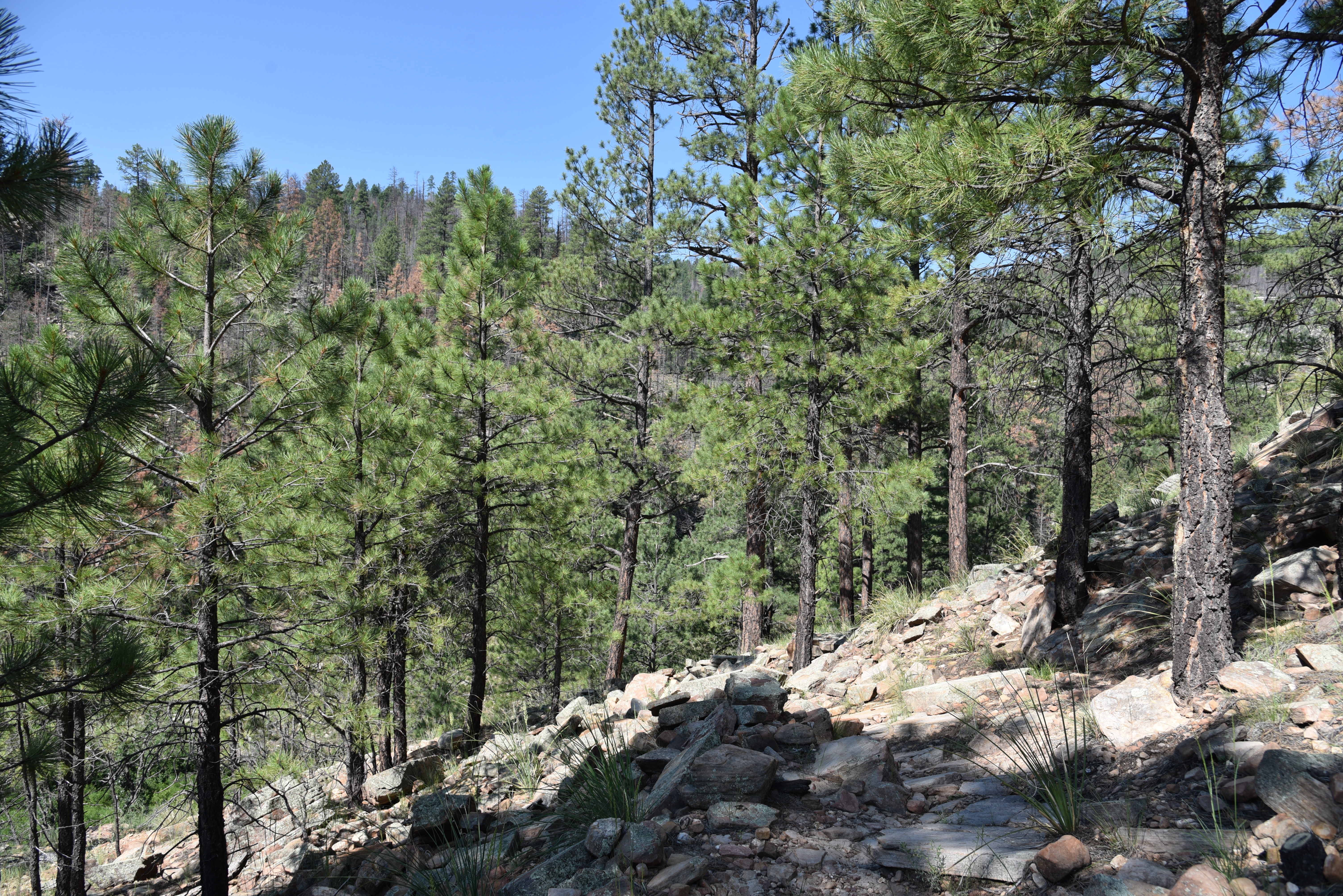
McCarty Ridge seen from FR6033C

Forest Road 6033C reveals no obvious destination, its purpose is veiled in a tangle of pines.

A drought-stricken wildlife water hole on FR6033C

The backwoods road located a couple clicks north of the community of Clints Well on the Mogollon Rim is signed but not shown on forest service maps.   It runs on the terraced slopes above the course of East Clear Creek in Coconino National Forest west of the popular Blue Ridge recreation area and C.C. Cragin Reservoir.
Several side roads offer more exploratory options

Passage 27 of the Arizona National Scenic Trail winds over Battleground Ridge through the busy hot spot on its way north to Utah. Camper convoys, boat trailers and conga line of backpackers and day hikers speak to the area’s magnetism for heat-weary outdoor enthusiasts.  With so many rich hiking opportunities nearby, the logic for walking on a non-descript dirt road lands squarely between why and why not.
Kaibab pussytoes bloom May - July

The FR6033C hike is clocked from a gate just beyond the dispersed camp sites on Forest Road 9033H.  Within a half mile, the road meets its first junction where FR6033C continues left.  From the junction, the deeply rutted track is an endless series of ups-and-downs that hop drainages, draws and ridges, accumulating over 1,000 feet of elevation change. For a mind-clearing, uncrowded excursion, there aren’t many distractions. 

A horned lizard vogues for the camera

A wildlife water tank and several signed side roads that appear to disintegrate a few yards in are the only disrupters in an environment dominated by Ponderosa pine trees with their signature straight-arrow trunks and rounded canopies.  Forest water tanks are often dry in summer before the monsoons kick in, putting wildlife at risk. Arizona Game & Fish Department receives no general fund tax dollars to  maintain 3,000 wildlife waters including created catchments around the state and relies on donations to deliver life-saving water to drought-stressed locations. (Not necessarily the water hole shown here.)
Solitude not far from popular recreation sites

You can help by donating at azwildlifehero.com.

At the top of several rises, conifer-fleeced McCarty Ridge cuts a prominent profile on the southeast horizon. Except for wind-rustled branches and the scurrying of critters, it’s blissfully quiet. At the 2.5-mile point, in a shaded hallow, the road veers north and becomes sketchy enough to call it a turnaround point.

LENGTH: 5 miles round trip

RATING: moderate

ELEVATION: 6,894 – 7,132 feet (1,107 feet of elevation change)

GETTING THERE:

From the State Route 87/260 junction in Payson, go 40 miles north on SR87 (past Clints Well) to Forest Road 9033H on the right past milepost 292.

SEND WATER:

Arizona Game & Fish Department

Wildlife Hero Program

https://www.azwildlifehero.com/programs/lifesaving-water?gad=1&gclid=EAIaIQobChMI_7rjkcSEgAMVfg-tBh2KdgcnEAAYASAAEgKf7PD_BwE


Monday, June 27, 2022

Willow Crossing

WILLOW CROSSING

The limestone arch in Willow Valley

Tucked into a sliver of space in the canyon-addled watershed of West Clear Creek, Willow Valley is a calm oasis of green in an water-carved landscape.  Within the shallow canyon, a sketchy trail known as Willow Crossing descends from an airy plateau littered with toppled trees from past wildfires, wildflower meadows and a smattering of tall pines into a narrow canyon with a totally different character. 

Inside the riparian zone of Willow Valley

Bound by chalky limestone walls chiseled into layer-cake-like formations, the ecozone inside the mini, Mogollon Rim gorge transforms from a sunny, lightly-wooded mesa into a jungle of greenery. 
The rim above Willow Valley in Coconino National Forest

This tiny Eden isn’t easy to find or follow, but careful explorers are rewarded with many surprises. A series of rough dirt back roads near Clints Well in Coconino National Forest northeast of West Clear Creek Wilderness, lead to a barely-there trailhead. To pick up the historic route, follow the old barbed wire fence to a gate near the edge of the canyon. Pass the gate (close it behind you) and pick up the obvious path leading downhill.
Riparian vegetation in Willow Valley

As the short, rocky trail descends among hairy stands of common mullein that can sprout corn-like shoots to over 6 feet high, riparian vegetation closes in on the trail.
Common mullein grows on the canyon rim

Willow Valley is in the watershed of West Clear Creek

Gamble oaks, boxelder, New Mexico locust and a tangle of the eponymous willow trees clutter the slopes. Where the trail bottoms out at a drainage, look for water-loving wildflowers and shrubs like larkspur, wild roses and red-osier dogwood. 
Larkspur colors the trail in summer.

Like all “crossing” trails on the Rim, this one hops the drainage and heads up to the opposite lip of the canyon. In between the rims, the hike’s signature attraction stands nearly obscured by tree cover and wild grape vines woven among thickets and boulders.
Red-osier dogwood grows in the drainage area

A delicate natural arch carved from the canyon’s sedimentary rock walls forms a fragile bridge over a fold in the disintegrating wall revealing a glimpse of sky and Ponderosa pines 400 feet above.

LENGTH: 2-3  miles round trip

RATING: moderate

ELEVATION: 6,400 – 6,800 feet

GETTING THERE:

From Payson, go north on State Route 87 to Lake Mary Road (County Road 3) turn left and go north on CR3 to Forest Road 81 at milepost 297.7. Turn left and continue 3.1 miles to Forest Road 81E. Set your odometer, and go left on FR 81E 1.14 miles to Forest Road 9366M—an easy-to-miss, unmarked dirt road on the left. Go 0.5 miles on FR 9366M to a cattle guard and gate. The trailhead is just past the gate on the left near the generic “trail” sign and rock cairns. A high clearance vehicle is recommended on the forest roads.

INFO:

Coconino National Forest

https://www.fs.usda.gov/recarea/coconino/recarea/?recid=55052


Thursday, August 5, 2021

Kinder Crossing

KINDER CROSSING

East Clear Creek 

When dogs dream about hiking, images of Kinder Crossing dance in their heads. Tucked into a picturesque canyon with a perennial stream, the trail that leads to an idyllic water-carved passage packs every imaginable doggie delight into a single hike. Scampering rock squirrels, taunting blue jays, jumping fish and leaping frogs give chase, inciting primitive stirrings in even the most sophisticated of city dogs.  Sandy beaches along East Clear Creek beckon dig-happy hounds and a plethora of swimming holes stoke the canine “inner wild” into overdrive. Humans too will find much to admire along historic Kinder Crossing Trail No. 19 in Coconino National Forest.  Originally used to drive sheep through the rugged canyons of the Mogollon Rim, the steep, rocky trail descends nearly 500 feet along the crumbling, fossil-laden limestone walls of Yeager Canyon.

Damage from the Tinder Fire seen from the trail

Like many forested areas in Arizona, the difficult-to-access backcountry surrounding East Clear Creek was recently damaged by wildfire.  

Parts of the trail sustained only light fire damage

In 2018, the human-caused Tinder Fire that began with an illegal campfire set during stage one fire restrictions which ban campfires anywhere other than in a developed campsite or picnic area, went on to char over 16,000 acres of mixed-conifer woodlands and critical watershed terrain east of C.C. Cragin (Blue Ridge) Reservoir.  
Limestone escarpments line East Clear Creek

All told, the blaze cost nearly $7 million in suppression costs, endangered the lives of first responders and destroyed 33 homes in communities along State Route 87.  That was quite an expensive campfire.  The unknown perpetrators live with that.
Wild geranium grow along the route

Three years post fire, the viewscape from the top of the trail is one of teetering ashen matchsticks, spots of half-cooked pines and sheets of toppled trunks cascading over scorched-earth ridges and exposed stone knobs previously obscured by tree cover. 

The creekside path is very overgrown

But, the depressing start belies what lies below.  A few yards into the trail,  ledges dangling over sheer escarpments serve as a platforms for first glimpses of a meandering green riparian zone hugging the twisted stream.
Beware of sharp New Mexico locust thorns 

Rife with loose rock and tangled roots, the newly sun-exposed slopes have morphed from a previously dank mushroom-and-moss alcove into emergent plots of common mullien and fragrant cliff-rose shrubs that pull nutrients from deadfall and disturbed soils.  The first half-mile is a relatively easy traipse with a barely noticeable descent, but that changes where a primitive rock cairn signals where the trail goes full tilt into a switchback-mitigated spiral to the creek.  

Cliff-rose shrubs scent the upper trail

As the trail inches closer to the stream, the bleakness of the burn scar spills into a canyon-bound corridor lush with moisture-hungry willows, alders, brambles, wild geraniums and penstemons.

A toppled pine lies over the trail


Once at the creek, footpaths trace the flow as it winds through high grasses, sandbars and still pools that lap at colorfully-layered canyon walls. 

Limestone slabs on the switchbacks

It’s just a three-quarter mile descent to the creek, but the trail continues downstream (go left at the bottom of the trail) for just under a mile to the crossing where the route head up the opposite embankment to Forest Road 137. 
Wild potato is a rare find on the trail

At this writing, the creekside trail was overgrown, mucky and difficult to navigate.  
Tinder Fire scar visible from a trail overlook  

Thickets of thorny New Mexico locust make bloody work of getting through the quagmire.
Before fire canyon overlook July 2007

The trailhead is 0.2-mile from the parking area

 
Stay alert while hiking in the Tinder Fire scar

The hike along the creek reveals tiny waterfalls and slickrock cascades spaced among rockfall and tall survivor pines.  
Common Mullien bloom in the ashes of the Tinder Fire

Elk, deer and black bears might be spotted wallowing in perennial swimming holes--that is, if visiting dogs didn’t get there first.
Before fire creekside, July 2007

A quiet pool in East Clear Creek

LENGTH: 1.5 miles round-trip

RATING: moderate

ELEVATION: 7,000 – 6,417 feet

GETTING THERE: From Payson, go north on State Route 87 to Forest Road 95, which is located roughly 10 miles north of Clints Well between mileposts 299 and 300. Turn right onto FR 95 and continue 4.5 miles to the turn off on the left for Forest Road 95T and follow the signs 0.6-mile to the parking area. The official trailhead is another 0.2-mile down the road. A high clearance vehicle is required on FR 95T. Those with low clearance vehicle should park along FR 95 and hike FR95T. 

INFO: Coconino National Forest

https://www.fs.usda.gov/recarea/coconino/recarea/?recid=54998


Monday, May 20, 2019

BAKER BUTTE

BAKER BUTTE
Lilacs frame Baker Butte fire tower on the Mogollon Rim
A hike up to Baker Butte culminates at an idyllic, pine-shaded pinnacle. Swarms of hummingbirds whip through lilac-scented air and masses of ladybugs cling to trees, shrubs and knee-high wildflowers.
Fire lookout Shirley Payne and her horse Rameses.
Nearby, a horse chomps hay in a makeshift corral while a friendly black Labrador retriever noses a tennis ball. Perched on a knoll at the edge of the Mogollon Rim, the mood surrounding the Baker Butte fire tower is as calm and pastoral as a romantic passage in a Victorian novel.

Pine thermopsis (golden pea) bloom April - July
But this enviable life removed from city heat, traffic and noise belies a very serious purpose.
“Are you coming up?” The voice of fire lookout Shirley Payne broke the silence as she called down to me and my hiking partner from the catwalk of the 30-foot-high tower. “Oh, yeah,” was my no-brainer answer.  Payne, who has worked in the tower for 23 years, welcomed us with a plate of fresh-baked poppy seed muffins.
Payne's dog Jeffrey takes a break near the corral.
The tower is located near the western edge of Rim Road (Forest Road 300)--a 51-mile dirt route that runs between State Route 87 south of Clints Well to State Route 260 near Forest Lakes. Rim Road makes for an iconic scenic drive for anybody with a high-clearance vehicle and the fortitude to endure some queasy, edge-hugging sections. Of the many Coconino National Forest fire lookout towers that dot the Rim, Baker Butte is one of the easiest to reach on foot. For a moderate 3-miler, park at Baker Lake (usually not more than a soggy bog) at the junction of FR 300 and SR 87 and hike 1.2 miles on FR 300 to Forest Road 300B (the road to the lookout) where there’s a parking area for the General Crook Trail, then continue 0.4-mile uphill to the summit. The summit road passes through archways of Gambel oak trees, pines and Douglas firs. Fringed with ferns, raspberry brambles and colorful spreads of Canada violets, Pine thermopsis, sandwort and wild strawberries, the road twists uphill in long loops landing at the base of the fire tower.
Views from tower catwalk stretch from Flagstaff to Tucson
The tower, which earned a spot on the National Historic Lookout Register in 2006, wears its heritage well. Constructed with a not-so-subtle blend of original, repurposed and new building materials, the practical yet homey loft is softened by Payne’s collection of quilts, plants and mementos.  Neatly arranged instruments, radios, binoculars and maps speak to the intense, sometimes harrowing, work of fire spotting and coordination of incident response teams—the daily grind of a fire lookout.
Thick tree cover on the summit road hike.
The long-gone original tower cabin that was built in 1921 was replaced in 1937 with the present 12’ x 12’ model that’s perched on a metal skeleton with wooden stairs. The catwalk was added in 2009 and various upgrades to walls and windows surround a floor covered in speckled, cracked linoleum that smacks of mid-century utilitarianism.
Copies of Payne’s book, Baker Butte Journal 2010, sit near the guest register. Well worth its $20 sale price, the photo-rich volume presents a slice-of-life account of a season in the tower. It's packed with play-by-play descriptions of wildfire response, turbulent mountain weather, recipes and the misadventures of “cidiots” (visitors from cities with irresponsible forest habits) who litter, cause damage, raise hell and sometimes need rescuing.  A stroll around the catwalk reveals see-forever vistas. On most days, the peaks of Flagstaff, Williams and the White Mountains can be seen with the naked eye standing over seas of Ponderosa pines. On the best days, Picacho Peak and Mount Lemmon in Tucson show their silhouettes 200 miles to the south. 
Jeffrey is always ready for a game of fetch
Payne offers fresh-baked muffins to tower visitors.
Below the tower, a tiny cabin serves as Payne’s home for six months (usually May – October) each year. Draped in lilac bushes that were planted in the 1980s, the ad hoc abode has been expanded, adapted and upgraded over decades of use.
Hummingbirds gather at feeders placed around the tower
Tools of a fire lookout's trade.
The sunny kitchen was salvaged from a Depression Era Civilian Conservation Corps camp at Mormon Lake and repurposed into a compact, fully-equipped work space (with hot and cold running water to boot) where Payne cooks up her culinary specialties like the yummy muffins she serves visitors.  Some of her recipes use wildflowers and berries harvested from the forest.
Payne's book describes her experiences working in the tower
Outside, an array of hummingbird feeders attract several species including the Broad-tailed, Rufous and Magnificent. During summer, flocks of the glinting little birds can drain a feeder in just hours, which keeps Payne busy with refill runs up to three times a day. In addition to the elk, chipmunks, turkeys, western tanagers and deer that hang out around the tower, Payne keeps two special four-legged helpers at her mountain top work environment. Rameses, a 21-year-old Missouri Fox Trotter--a gaited breed (horses with a sure-footed, rhythmic stride) who loves mint candy treats, and Jeffrey, a friendly  3-year-old black lab with a fetch fetish and boundless energy provide companionship and assistance. 
Raspberry brambles produce fruit in late summer
During fire season, the Baker Butte tower is open to the public between 8:00 a.m. and 4:30 p.m. when Payne is on duty and closed for lunch between noon and 1 p.m.
The cabin kitchen was salvaged from a CCC camp
Canada violets bloom April - September
As Arizona heads into another fire season, forest visitors should respect fire restrictions and safety protocols. The last thing any fire lookout wants to see is a plume of smoke drifting skyward from a human-caused blaze.  When visiting a fire tower, please observe proper etiquette.

• Respect visiting hours. Do not attempt to enter a tower when no lookout is present.
• Wait to be invited. Lookouts may not allow visitors when monitoring an active fire incident.
FR 300B begins across from a General Crook trailhead
• Lighten up. Leave bulky packs and trekking poles behind. Tower stairs are narrow and space is tight inside.
• Ask permission before taking photos or approaching companion animals.
• Listen up. Follow the lookout’s instructions and don’t touch instruments. 
• Learn something. Ask questions. Most lookouts are veritable founts of knowledge about the forests they watch over.
Begin at Baker Lake (bog) for a 3-mile hike to the tower.

LENGTH:  3 miles roundtrip from Baker Lake or 0.8 mile roundtrip from the General Crook trailhead.
RATING: moderate
ELEVATION:  7430 - 8074 feet from Baker Lake or 7866 – 8074 from General Crook trailhead.
GETTING THERE:
From the State Route 87/260 junction in Payson, go 28 miles north on SR 87 to Forest Road 300 (Rim Road) located just past milepost 281.
Option 1: Park in the dirt turnouts on Rim Road near Baker Lake just a few yards in from SR 87.
Option 2: Follow FR 300 (make a sharp left at a Y junction at  0.1-mile)  1.2 miles to the Baker Butte Summit Road (FR 300B). There’s parking directly across from the summit road in the General Crook trailhead. Forest Road 300 is bumpy dirt but passable by passenger cars.
INFO:
Fire Management Coconino National Forest
-->

Monday, June 25, 2018

PIVOT ROCK CANYON & WILDCAT SPRING

PIVOT ROCK CANYON & WILDCAT SPRING
Iconic Pivot Rock is the hike's keystone.
Lodged between the epic wilderness areas of West Clear Creek and Fossil Creek, the woodlands around Pivot Rock Canyon provide a quiet transition between the two recreational juggernauts.  Although it lacks the deep gorges, waterfalls and hiking challenge of its surrounding destinations, the unassuming little space on the Mogollon Rim holds fascinations of its own.  
Limestone slabs in Pivot Rock Canyon
Easily accessible off State Route 87 just south of the community of Clints Well, the area can be explored using a 1930s-era Civilian Conservation Corps campsite as a base.
From the no-frills dirt clearing, two short treks with distinct flavors head out in opposite directions. 
Butterflies congregate near the springs.
The woodsy, informal routes located just outside of the wilderness boundaries use abandoned roads and footpaths to explore an array of human artifacts and bizarre geology.
Often eclipsed by the epic, vertigo-inducing trails that scale the raw and remote cliffs of WCC (Tramway, Maxwell, Calloway) that are accessible only via tire-eating dirt roads, the Pivot Rock Canyon and Wildcat Spring trails emanates a softer character than their untamed, wilderness cousins.
Remains of a backwoods cabin.
Payson Packers maneuver through a fern gully.
The double-header circuit begins across the road from the campground at a “road closed” barrier with a walk to Wildcat Spring. Pass through the gate and follow the faint two-track, veering right (downhill) where the road splits. The road soon narrows to a footpath as it enters a shallow canyon meandering along the edge of an ephemeral stream.  The sketchy trail weaves among brambles, hip-high ferns damp forests and sunlit meadows. Several spur paths and game trails spin off the main route, but the best plan is to follow the paths-of-use on the canyon floor.  At 1.4 miles, the canyon converges to a point with evidence of runoff funneling down into the stream channel. Wildcat Spring is located up on the east wall of the canyon. A short scramble up to the defunct concrete trough reveals rusty pipes and a crudely-poured square tub holding more pine needles than water.
Wildcat Spring is usually bone dry.
On the flip side, the Pivot Rock Canyon hike is a little more convoluted. Begin hiking on the road at the end of the campground. At the 0.6-mile point, pick up an unsigned footpath on the right heading downhill to a creek channel. (For reference, there’s a small dirt clearing with a fire ring.)
Members of the Payson Packers hike group trek the roads.
Hop down the limestone slab staircase, head right and follow the obvious paths that crisscross the drainage smothered in pine-oak woodlands and aspen-shaded clearings.  The paths move through a narrow corridor bolstered by outcroppings of layered fossiliferous limestone that harbor water pockets, impressive overhangs and shallow caves. Roughly a half-mile into the canyon, keep an eye out for the eponymous rock formation on the upper left embankment. The easy-to-miss, natural limestone sculpture known as Pivot Rock hides in plain sight above the ravine.  Its massive foundation supports a balancing capstone posed like an abandoned project on a potter’s wheel.  A frenzy of wild grasses and tree sprouts have taken root in its porous, flaky surfaces. Nearby, a toppled pine tree lies shattered at its base, a near-miss that could have crushed or sent the monolith over the edge.
Once done visiting the rock, continue hiking the faint path that winds among gooseberry bushes, brambles and gigantic ferns to a point where tiny pools lush with White Watercress, Yellow Monkey flowers and swarms of butterflies and moths herald the approach to Pivot Rock Spring. 
An Orange Gooseberry thicket.
Even in our current extreme drought conditions, a trickle of water still flows from the spring’s location high on the canyon wall. Icy air and a glaze of sweet water oozes from the spring's cave-like source.
Pivot Rock Spring spews cool air and a trickle of moisture.
From the spring, backtrack to the access road and continue hiking the two-track north. Along the way, off to the left, a decaying pile of rough-hewn logs is all that remains of a backwoods cabin. 
White Watercress thrives near Pivot Rock Spring.
This is a favorite turnaround point for an easy day hike, however, it’s possible create your own circuit using the area’s maze of dirt roads and the Coconino National Forest road map for guidance.
LENGTH:
Pivot Rock: 3 miles roundtrip or up to 6 miles using linking forest roads.
Wildcat Spring: 2. 8 miles roundtrip
RATING: easy
ELEVATION: 6780 – 7100 feet
GETTING THERE:
From the State Route 260/87 junction in Payson, go 32 miles north on SR 87 to Forest Road 616, which is located past milepost 284 on the left. Follow FR 616 for 3.3 miles to an unsigned campground downhill on the right.
The Pivot Rock trail begins on the road at the end of the campground.  The Wildcat Spring hike begins across from the campground at a closed gate.
Limestone escarpments in Pivot Rock Canyon
INFO: