


 Posts
Posts


CREST SUMMIT
Mine site on the Quartz Mine trail
Situated
in at the southern end of the White Tank Mountains, Skyline Regional Park in
Buckeye offers an enticing mix of hiking, biking and equestrian trails. Big Valley views from Crest Summit
The 8,700-acre park has nearly 20 miles of
interconnected trails that wrap around a stronghold of mountain peaks, scoured
washes and lofty ridgelines. Crest Summit trail is short but very steep
With trail
choices that range from barrier-free interpretive strolls to difficult,
vertigo-inducing climbs, there’s something for everybody in this West Valley recreation
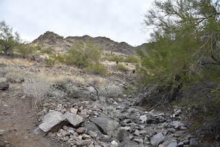
hub. Quartz Min trail passes through washes
While all the park trails frame
outstanding vistas, there’s one edge-teetering route that skims the roof of the
park and even ties in an optional summit side trip. Lichens color rock outcrops in Skyline Regional Park
The circuit, which uses the Quartz Mine, Lost
Creek and Skyline Crest trails, wanders through the park’s east sector with a
sequence of twists, dips and ascents that provide continual panoramic
views. Challenging Skyline Crest trail traces a ridgeline
Begin on the Quartz Mine trail
near the number 3 picnic ramada. Head
east (go left) follow the moderate single track through gullies and washes as
it descends along stony escarpments above desert plains. Steep switchbacks on Skyline Crest trail
At the 1.4-mile point, the route meets the
Skyline Crest junction. For this trip, continue uphill on Quartz Mine. Now
steeper and more precipitous, the trail curves north, topping out near a mound
of chipped white stone spilling from what appears to be a filled in
prospect—the Quartz Mine. Trail menu at Skyline Regional Park
The trail
traverses a ridge for another 1.1 miles to where it connects with the Lost
Creek trail. Turn left, hike less than a half-mile and hang another left onto
the Skyline Crest trail. This leg of the
circuit is a real treat. Rated difficult, the rocky, undulating path hugs a
knife-edge ridgeline with steep drop offs and jaw-dropping views all
around. After a mile, a set of switch
backs winds downhill to land hikers on a saddle where the optional Crest Summit
trail presents an optional add-on. Park trails are well signed
The
short, vertical side trip tacks on only 0.34-mile to the hike, but the
additional 200 feet of elevation gain rolls out in aggressive, straight-up
style. The extra effort pays off with
unobstructed, 360-degree vistas of the Sierra Estrella Mountains to the
northeast, Gila Bend Mountains in the southwest and the Big Horn Mountain
Wilderness and the Hassayampa Plain in the northwest. Quartz chunks line the trails
From this high-point lookout, the trail
descends through a saguaro-cluttered ravine to reconnect with the Quartz Mine
Trail where hikers retrace their steps to the trailhead.




LENGTH: 5.94 miles as described here
RATING: difficult
ELEVATION: 1,345 - 2,130 feet
GETTING THERE:
2600 N. Watson Road, Buckeye.
From Interstate 10 in Buckeye, take the Watson Road exit and continue 2 miles north to the park. Roads are paved. There are restrooms, water, picnic ramadas and camping by reservation at the trailhead.
HOURS: sunrise to sunset daily
INFO & MAPS:
Skyline Regional Park
https://www.buckeyeaz.gov/community/skyline-regional-park/about-the-park


