Find A Trail. Start Your Search Here:

Showing posts with label Pemberton Trail. Show all posts

Thursday, December 27, 2012

Ridgeline hike above the Verde River Valley


Holiday surprise on the trail: Dec. 24, 2012
SCENIC TRAIL
McDowell Mountain Regional Park, Fountain Hills

With 20 trails laced over 21,000 acres of Verde River Basin desert, selecting a hike in this northeast Valley county park can be a dilemma. Therefore, I submit a suggestion---begin with Scenic Trail to get a fast and easy overview of the park layout.  Scenic Trail leaves from the main trailhead staging lot making a lasso-loop up and over the Lousley Hills.  Although the Rio Fire ravaged some of the area in 1995, once up on the ridgeline, the land returns to beautiful Sonoran desert glory.  Because much of the route follows the backbone of the Hills, the trail lives up to its name by offering double-edge views of the entire park, the town of Fountain Hills (look for the famous fountain at the top of each hour), the Verde River Valley and the green pecan and citrus farms of the Ft McDowell Indian Reservation.  A memorial bench on the crest provides a nice meditation or water break spot.  Here, look for an unusual crested saguaro on the downhill slope.  It's unique because the fan-like deformation is on one of the cactus' arms instead of on the top.
Overlooking the Verde River Valley

LENGTH:  4.3-mile loop
RATING:  moderate
ELEVATION:  1860' - 2011'
FEES:  $6 daily fee per vehicle, $2 walk or bike-in, annual passes available.
FACILITIES:  restrooms, water, visitor center, picnic tables, camping
GETTING THERE:
From Phoenix, go east on Loop 202 to Beeline Highway (SR87). Head north on SR87 to Shea Blvd, turn left and drive less than a mile to Saguaro Blvd, turn right and continue to Fountain Hills Blvd, turn right and continue 4 miles to the park entrance. Pay your fee and drive thru the park to the main trailhead staging area at the end of Shallmo Drive.  Maps are available at the park entrance and visitor center.
A curious coyote checks us out

INFO: Maricopa County Parks & Recreation, 480-471-0173

MORE PHOTOS:

Monday, November 12, 2012

Edge of the suburbs desert hike


ROCK KNOB-PEMBERTON-BOULDER-MARCUS LANDSLIDE LOOP
McDowell Sonoran Preserve-McDowell Mtn. Regional Park
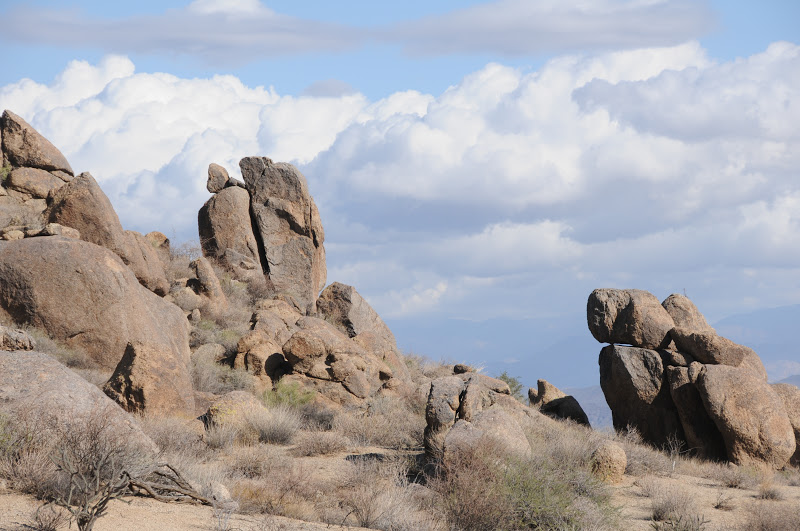
Boulders near Rock Knob

With a glinty grainy tread way of decomposing granite underfoot and haze-muddled views of the Mazatzal, Superstition and McDowell Mountain ranges hugging the horizon, this spectacular loop hike in a shadeless basin of Sonoran Desert showcases a lot of what we love about our local landscape.

Cradled between a preserve area and a county park, this swath of boulders and cholla is a stubborn holdout amidst garrisons of swanky golf communities lapping at its fringe.  Thanks to the foresight and persistence of concerned citizens, this precious local gem remains closed to development and open for climbing, hiking, biking and equestrian activities.  Although its proximity with the red-tile-aqua-pool suburbs of Scottsdale and Fountain Hills puts a mild pox upon the wilderness experience, the up side is easy access to the great outdoors.  My favorite part of this thrown together trek is the geology and the big-sky views.  The route passes by the jumble of granite known as Rock Knob, the lower end of Marcus Landslide and numerous stone "sculptures" and "mushroom" rocks.  As the terrain is rather flat, there are unobstructed vistas---look for Superstition Wilderness landmarks Weaver's Needle and the Flatiron in the east and, if you hit the trail at the right time, you'll get a peek at the famous waterspout in Fountain Hills. A spur path on the return leg of the loop leads to a lookout spot with an interpretive sign identifying these key features.
Saguaros on the Boulder Trail

HERE'S THE HIKE PLAN:  from the trailhead, hike 0.3 mile east on the Marcus Landslide Trail to the junction for Rock Knob Trail.  Follow Rock Knob 0.5 mile to the McDowell Mtn Park boundary where you'll need to deposit $2 and secure your permit.  Continue another 0.6 mile on Rock Knob to Pemberton Trail, turn right (southeast) and hike 1.1 miles to Boulder Trail.  Pick up Boulder and continue 1.1 mile to Marcus Landslide (back in the preserve), turn right (north) and trek 1.4 miles back to the trailhead.

LENGTH:  5 miles according to park maps; 5.4 miles by my GPS track
RATING:  moderate
ELEVATION: 2,800' - 2,280'
FACILITIES: restroom at trailhead, no water
FEE: $2 per person to enter McDowell Mtn Regional Park (exact change req)

GETTING THERE:
Tom's Thumb Trailhead:
From the loop 101 in Scottsdale, take the Pima/Princess Road exit 36 and continue 5 miles north on Pima to Happy Valley Road.  Turn right (east) and go 4.1 miles on Happy Valley to Ranch Gate. Turn right on Ranch Gate, follow it 1.2 miles then turn right onto 128th St. and continue 1 mile on 128th to the signed trailhead. Roads are paved all the way.
INFO:

MORE PHOTOS: