Find A Trail. Start Your Search Here:

Saturday, December 8, 2012

Desert beaches and a “hang five” saguaro


SAN TAN TRAIL
San Tan Mountain Regional Park, Queen Creek
Rock Peak and the Malpais Hills

the "hang five" crested saguaro
Part of the fun of visiting this desert park on the southeastern fringe of Maricopa County is the drive down Ellsworth Road through Queen Creek.  It’s a 13-mile stretch of cow pastures, cotton farms and horse corrals tossed together with acres of stucco and strip malls.  At the base of this suburban-rural interface is San Tan Mountain Regional Park—10,200 acres of pristine Sonoran Desert with 20 miles of shared-used trails ranging in difficulty from easy to strenuous. All of the park's nine trails are well-signed and laid out so users can easily cobble custom treks, but when the park ranger told me there was a rare crested saguaro and a petroglyph site on the San Tan Trail (SA) , choosing a route was a no-brainer for me.  Using the park map available for free at the visitor center, I planned my hike around those two features.  Except for a few places where the trail follows sandy washes---which is similar to strolling on a beach---the route is a walk in the park.  One short, minor climb leads to the crest of a ridge with astonishing views the park's signature geological features---Rock Peak and the Malpais Hills.  From this breezy vantage point, you can do a visual walk through of the return leg of the hike.  The petroglyph site is located a quarter-mile downhill from the crest.  Look for a jumble of granite on the left.  The rock art here appears to be quite ancient and only one incised design stands out. To see the crested saguaro, continue past the Rock Peak Wash junction, turn right to stay on SA and hike a few yards to where the trail makes a sharp left swerve and heads up an embankment.  From here, you can catch a first glimpse the plant’s famous “hang five” (or "I Love You" in American Sign Language)  gesture about 0.1-mile down the path.   To complete the loop, continue hiking north and take any of these connector trails: Hedgehog, Moonlight or Goldmine-Littleleaf.
Sonoran Desert "beach"

LENGTH:  7.4-mile loop (6.4 on San Tan, 0.4 on Goldmine, 0.6 mile on Littleleaf)
RATING:  moderate-difficult
ELEVATION:  1,160’ – 1,800’
FEE: $6 daily fee per vehicle
FACILITIES: restrooms, water, visitor center, wildlife exhibit, tortoise habitat, ranger-led activities
HOURS: open 365 days a year, Sunday-Thursday: 6 a.m. to 8 p.m., Friday-Saturday: 6 a.m. to 10 p.m.
PETS: leashed pets are allowed
GETTING THERE:
From Phoenix, travel east on US60 to Ellsworth Road exit 191.  Follow Ellsworth 13.6 miles south (Ellsworth turns into Hunt Highway after about 12 miles) to Thompson Road (traffic signal), turn south (right) and go 2.1 miles to Phillips Road, turn right again and continue 1 mile to the park entrance.
INFO: Maricopa County Parks & Recreation, 480-655-5554
MORE PHOTOS:

Wednesday, December 5, 2012

Re-thinking Richinbar Mine


NEW PERSPECTIVES ON THE HISTORY OF RICHINBAR MINE
For your consideration.....

One of the great things about the blogosphere is its networking opportunities.  Because of this blog, I frequently receive emails from like-minded hikers and outdoor enthusiasts telling me of obscure routes, warnings of road closures and contributing interesting info about various AZ trails.  Recently, local mineral expert Gary Carter shared some enlightening observations about Richinbar Mine (a very popular hike in the Agua Fria National Monument area) and gave me permission to share them with you, to augment your understanding of the area's muddled history.  Here are Gary's findings:
The Richinbar Mine area—sure is an interesting old site and easy to get to (which will eventually be its death).
Anyway, I have been out there many times and done some detailed reading and observations about the area at the Arizona  Geological Society (downtown Phoenix).They have a file of over 100 photos on  the Richinbar.
 My intent here is just to make sure you are aware of some falsehoods about the mine.
•      The Az. Pioneer Cemetery group are to be commended on what they are trying to do--however  not everyone agrees with their info or interpretations—especially. those with background/training in geology/mining. They also will not make corrections when they are notified of errors.
2     My background is in minerals and recently I also took an exploration geologist of long standing and  high regard to the site ---to confirm some of my thoughts and to see what else he could tell me. The  mine was not a rich one—in fact they were in pretty low grade ore for much of the time, they operated  on a shoestring.
4      Copper was never a major product from that mine---it was basically a tourmaline/ quartz vein with  minor gold they were following.
5      The two shafts further from the mill workings were probably dug first since the concrete footings for the first stamp mill are directly across from it on the Aqua Fria side of the slope.
        The  dump of waste rock sits right behind and below the Zyke shaft which fed the ball mill and circular cyanide tanks that have left their tailings and depression . Not near enough tonnage  to indicate they could or did process much ore.  A tailings pond (for waste material) is still evident as a small plateau like area of pinkish cyanide tailings below the now dry wash. There is no evidence –either visual nor in the research of any graves or burials on the property.

I have been involved in so much research on old mine sites where folks with no expertise or backup research (other than what they read on the net) have added to the historical falsehoods, myths and confusion. Can’t tell you how many phony stories –even TV docs and videos have been circulated about the old Vulture Mine, outside of Wickenburg. They were done by well meaning folks who did a modicum of reading, guessing and hypothesizing—yet passed on inaccurate info about the subject. Once done it is very difficult to “take it back” or correct it.
HIKE DETAILS:
LENGTH:  1.5 miles one way to the mine. 
(We wandered around the site for a total hike of just under 4 miles).
RATING: easy
ELEVATION: 3,370' – 3,497'
GETTING THERE:
From Phoenix, go north on I-17 (roughly 35 miles) to the Sunset Point rest area.  From here, continue 1.7 miles  to the turnoff for FR9006 on the right.  A windmill and stock tanks are your landmark. (if you reach Badger Springs Road, you've gone 2.3 miles too far. Turn onto FR9006 and park in the dirt lot being sure not to block the gate. The gate is usually locked, but it's easy (and legal) to squeeze through.   Roads are paved up to the dirt parking area.
INFO:
Agua Fria National Monument: general info and maps
https://www.blm.gov/visit/agua-fria
Arizona Pioneer & Cemetery Research Project: historical info and photos


Monday, December 3, 2012

Colorful late Autumn desert hike


CAMP CREEK FALLS
Cave Creek
Early December on Camp Creek

Camp Creek Falls
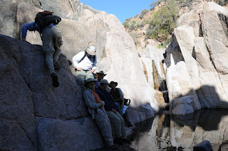
The innocuous, wildfire-tinged roadside pullout that marks the beginning of this hike gives little insight to the wonders that lie in the canyons below. This unmarked route ventures into the craggy desert canyons of Blue Wash and Camp Creek. Although this is not an “official” trail, it’s easy to stay on course by simply following the obvious footpaths and bends in the canyon. The first of several tricky spots happens at roughly the half-mile point where the trail seems to dead-end over a dry waterfall. Here, veer right and hike up above the rise following a narrow path-of-use. Once back in the gully, there are several more minor hand-over-foot rock scrambles to overcome before Blue Wash meets the wide, sandy course of Camp Creek. At this “T” intersection, head left and hike upstream, hopping the many rivulets that flow in meandering lacy currents. Soon, the rangy walls of a box canyon open up to reveal a cascade of water tumbling over a 20-foot-high granite escarpment. From here, those with good route-finding skills can opt to scramble up to the top of the falls and continue hiking north along Camp Creek where water-hungry reeds and velvet ash trees live side-by-side with drought tolerant cactuses and acacia. Please be respectful of the pockets of private property in the area.

LENGTH: 3.5 miles round-trip
RATING: moderate
ELEVATION: 3,243-2,643 feet

GETTING THERE:
From the Loop 101 in Scottsdale, take the Pima/Princess Road exit. Go north on Pima Road for 13 miles to Cave Creek Road. Turn right (east) onto Cave Creek Road and continue 6.5 miles just past a sign on the right that reads “Blue Wash #1”. Park in the gravel turnouts on either side of the road. The trail begins near the cottonwood trees.

INFO:
Cave Creek Ranger District, Tonto National Forest, (480) 595-3300