Find A Trail. Start Your Search Here:

Showing posts with label Pass Mountain. Show all posts

Monday, November 22, 2021

Pass Mountain Trail

PASS MOUNTAIN TRAIL

Goldfield Mtns & Four Peaks seen from Pass Mtn

In terms of sensory overload, the Pass Mountain Trail works sort of like an old-style 5-disk CD changer to deliver a cycle of ever-changing delights that once engaged, just keeps on spinning.

Approaching the east flanks of Pass Mountain

The 7.5-mile route that loops through both Usery Mountain Regional Park in Mesa and the urban-wildland interface of Tonto National Forest, packs in the hiking equivalents of mellow slow dance vibes, sultry tangos and pounding hip-hop rhythms. 

Mountain and valley vistas abound on Pass Mtn

An edgy section of the Pass Mtn Trail

Accessible by way of convenient trailheads in the park, the rocky single track blends low desert strolls, a carousel of vistas and just enough raw mountain exposure to serve up one of the most diverse, close-to-town hikes in the Metro Phoenix area.
A close-to-town hike with wilderness vistas
  Park rangers recommend taking on the loop from either the Wind Cave or Horse Staging trailhead in a clockwise rotation (begin by going left) for a longer but milder ascent to the hike’s scenic saddle.  For those who just want to get to the high point vista and then double back, that’s the ticket, however full-loop hikers should consider a counterclockwise (go right) approach.
Tangles of Sonoran Desert vegetation on Pass Mtn

It’s harder that way, but it gets the difficult climbing over quicker and eliminates the chore of negotiating a steep, slippery down climb on tired legs.

Pass Mtn viewed from the park side of the trail

  Heading right from the Wind Cave trailhead, the trail almost immediately exits the park boundary and enters Tonto National Forest. 
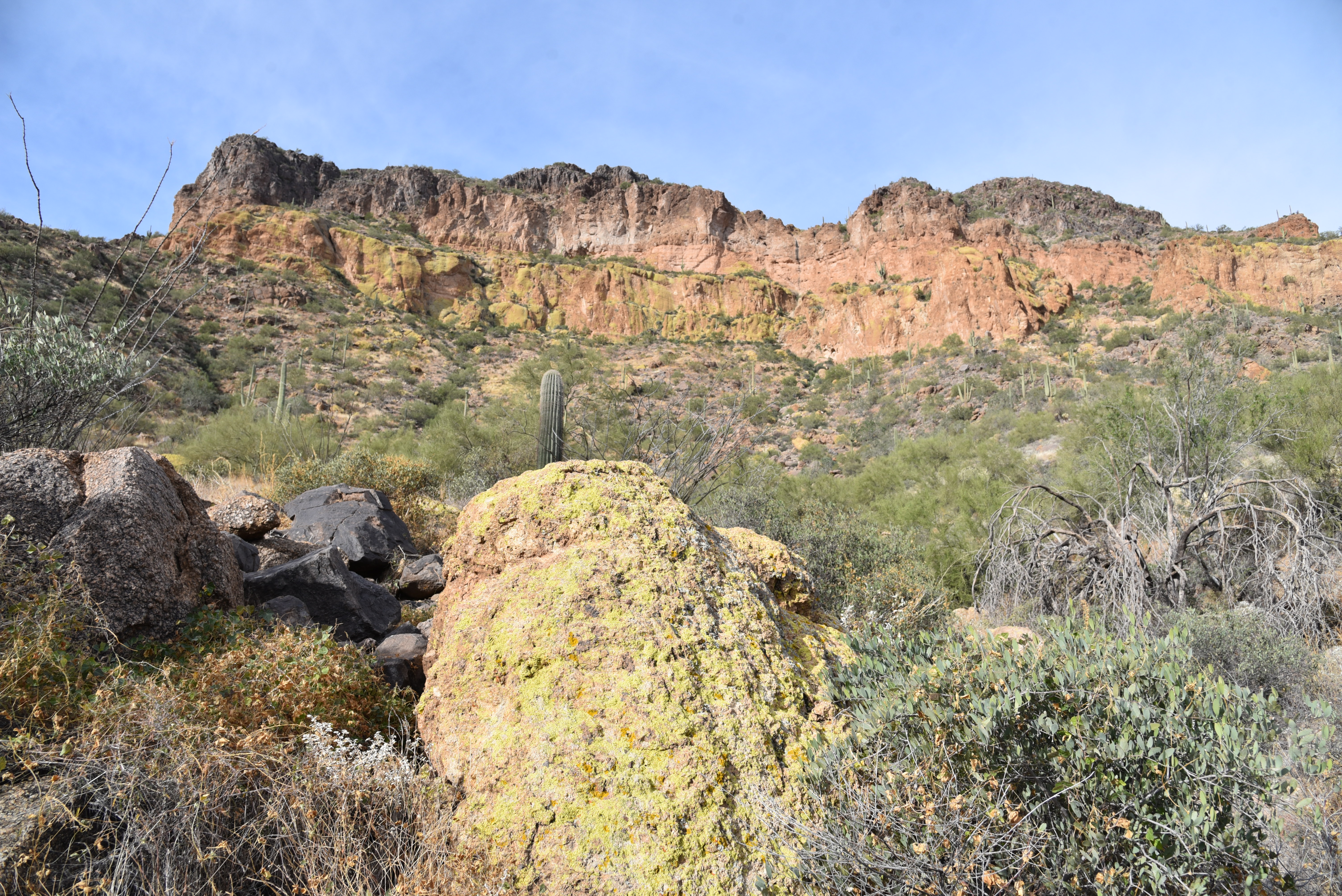
Lichens color the cliffs of Pass Mountain

The first relatively flat half-mile runs through classic desert vegetation and ruffled washes in the shadow of the pyramid-shaped Cat Peaks.  
A slickrock passage leads to a scenic saddle

Over the next mile-and-a-half, views of the Superstition Mountains rising above the town of Apache Junction command the eastern horizon as the trail makes a northward bend and a barely noticeable ascent toward on the mountain’s east face. 
Approaching the U-shaped saddle on Pass Mtn

Residual glimpses of rooftops and roads are soon swallowed up in the folds and drainage cuts of the mountain’s wild side. 
Stunning views from the Pass Mtn saddle


A valley flush with saguaros sits below the destination—a U-shaped pass visible on the north ridgeline.  The climb to get there isn’t too difficult until about a half-mile from the top where the route hangs on precipitous edges and a slickrock ledge for an appetizer of adrenaline before the trail emerges on the prize. 
The trail heads north from the saddle

Bam!  The wind-in-your-face jolt of stepping onto the 2,593-foot saddle is a jaw-dropping experience.  With a single bend in the trail, the vistas make an explosive transition from saguaros and suburbs to layers of mountains and river valleys.
A saguaro-cluttered valley precedes a steep climb

Mesquite and Palo verde trees shade the lower trail

 
In the foreground, the blocky, colorfully-layered Goldfield Mountains rise above a scoured divide.  Behind them, are the iconic Four Peaks and rows of wilderness peaks stand over the Salt River Valley.  
Another view of the saddle approach

View of the saddle on the right ridgeline

Save for some minor drainage crosses and exposure the remainder of the trail is just a moderate trudge that hugs the mountain’s eastern flanks, unspooling views of the Usery Mountains and hazy peeks at the McDowell range near Scottsdale before it swings south and descends to the base of Pass Mountain for the final 2-mile walk back to the trailhead.
Superstition Mountain views


LENGTH: 7.5-mile loop

RATING: difficult

ELEVATION: 1,866 – 2,598 feet

GETTING THERE:

Usery Mountain Regional Park,

3939 N. Usery Pass Rd., Mesa.

From U.S. 60 in Mesa, take the Ellsworth Road exit 191. Go 6.7 miles north on Ellsworth (which will turn into Usery Pass Road) to the Usery Mountain Regional Park entrance on the right.  The tail may be accessed from the Wind Cave and Horse Staging Area trailheads.  There are restrooms at both trailheads.

FEE: There’s a $7 daily fee per vehicle payable at the park entrance. 

INFO: https://www.maricopacountyparks.net/usery-mountain-regional-park-um/


Monday, September 21, 2015

BULLDOG SEGMENT of the MARICOPA TRAIL

MARICOPA TRAIL
Bulldog Canyon Trailhead to Pass Mountain Trail
Granite outcroppings on Maricopa Trail

Loop trails are fantastic inventions. Hiking on one feels sort of like a following a cinematographer filming a visually-rich sequence that ends where it began. Arizona has some impressive hiking hoops. Revered for their flowing, long lengths and community-unifying qualities, projects like the Flagstaff Loop Trail (42 miles), Prescott Circle Trail (54.4 miles) and the grand dame of them all--Maricopa Trail-- act as the glue for regional, non-motorized recreation systems. When complete (target 2017), the Maricopa Trail will form a 310-mile loop around Greater Phoenix, connecting parks, suburbia and surrounding cities. The thrill of trekking on fresh dirt is rekindled each time a new segment drifts into pristine tracts or provides an alternate path to familiar hiking haunts. With the recent opening of a 1.4-mile section in the East Valley, there's now another way to approach the popular Pass Mountain (PM) Trail. Previously, access to PM was only though Usery Mountain Regional Park or a lot off Meridian Road in Mesa. This new western approach from Bulldog Canyon Trailhead will eventually tie in with a yet-to-be-constructed corridor to the Granite Reef recreation area near the Salt River. Volunteers are needed to complete the work and you can sign up to be part of this historic effort by visiting the Maricopa Trail + Park Foundation website: http://mctpf.org/.
The "Bulldog" segment makes an easy, 300-foot ascent to the junction with 7.5-mile PM Trail (not signed). Roughly 5.6 miles of the PM loop trail is on the Tonto National Forest and there's no fee to hike on this scenic section. However, if you cross into the part of the trail that's in Usery Mountain Park, be prepared to pay the $2 per person fee (exact change required). You can avoid the fee by heading left at the junction. From here, its just under 2 miles to the saddle overlooking a valley straddling the desert space between the Superstition and Goldfield Mountains. This makes for a good turn around point for those left their wallets at home or are not up to the 10.3-mile circuit.
LENGTH: 1.4 miles one way (trailhead to PM)
or 10.3 miles roundtrip with Pass Mountain Loop
RATING: easy-difficult
ELEVATION: 2,010'- 2,340' (2,740' with PM)
FEE: $2 per person if you enter the park on foot. Exact change required.
GETTING THERE:
From Phoenix, go east on US60 to the Ellsworth Road exit. Go north 8.2 miles north on Ellsworth (turns into Usery Pass Rd.) to the trailhead corral on the right past milepost 22 which is 1.6 miles north of the Usery Mountain Park entrance.
Maricopa Trail:
Maricopa Trail + Park Foundation:
MORE PHOTOS:

Friday, February 11, 2011

PASS MOUNTAIN

PASS MOUNTAIN TRAIL Usery Mountain Recreation Area, Mesa A perennial favorite, we made a return trip to this trail last week---always a good choice for a beautiful local hike. There are actually many access points (both within the Usery Recreation area and via Tonto National Forest) to the Pass Mountain Trail as you will see on the map that is available at the park entrance. The counter-clockwise hike we did is easier and shorter than starting the hike elsewhere. Well-maintained and easy to follow, the trail makes a wide loop around Pass Mountain--the signature landmark of Usery Mtn Park--through desert terrain before climbing to a scenic pass overlooking the Salt River Valley, Goldfield and Superstition mountains. Although there weren’t yet many wildflowers in bloom, impending warmer temperatures over the next few weeks will coax out the color and vivid green leaves of the ocotillos that grow profusely along the cliffs. This is an EXCELLENT place to see Mexican Gold poppies and lupines. The park is open from 6 a.m. to 8 p.m. and offers nearly 30 miles of trails, many nice picnic areas and plentiful restrooms. LENGTH: 7.4-mile loop RATING: moderate ELEVATION: 2,030 – 2,588 feet BEST SEASONS: October - April GETTING THERE: From Phoenix, take U.S. 60 east to exit 191 which is Ellsworth and go north. Continue on Ellsworth (which will turn into Usery Pass Road) for 6.7 miles and then turn right onto Usery Park Road. Follow the signs to the Horse Staging Area and park there. The trail begins at the east side of the lot. There are porta potties but no water here. Other parking areas have flush toilets, water, and canned soda machines. FEES: $7 daily fee per vehicle payable at the park entrance. INFO:  http://www.maricopa.gov/parks/usery/pdf/2010maps/usery-8x11.pdf

Monday, February 22, 2010

WIND CAVE

WIND CAVE Usery Mountain Regional Park Seriously—this hike feels longer than its advertised 1.5-mile length. That’s because the long, lazy route takes its time climbing in sweeping, serpentine style from the desert floor up the cliffs of Pass Mountain to the famous cave for which it is named. Then again, the reason why this hike feels so long might be because there are so many things of beauty to behold along the way. Contorted rock formations, hefty clumps of ocotillo cactuses, blooming wildflowers and countless scenic overlooks make this trail one to savor. Given its many attributes, it’s not surprising that this trail is the park’s most popular attraction---so, you should expect a lot of company when hiking this one. As advertised, the trail ends at the “wind cave” a shallow depression in the cliff walls. Worn slick by the feet of countless visitors, the rock walls of the cave are home to dozens of chipmunks who aren’t shy about begging for the “people food” snacks that could make them sick. Please help protect the health of these amusing critters by NOT feeding them. LENGTH: 3 miles roundtrip. RATING: moderate ELEVATION: 2,020 – 2,840 feet GETTING THERE; From Phoenix, go east on U.S. 60 to exit 191, Ellsworth Road. Go north on Ellsworth for 7 miles to Usery Park Road, turn right and continue 1.7 miles to the horse staging trailhead. FEE: $7 daily fee per vehicle INFORMATION: Maricopa.gov/parks/usery/

Saturday, August 1, 2009

PASS MOUNTAIN

PASS MOUNTAIN TRAIL Usery Mountain Regional Park Situated on over 3,000 acres of unspoiled desert terrain just south of Mesa, Usery Mountain Regional Park has more than 29 miles of hiking trails. Pass Mountain trail is the most difficult and longest of the twenty designated routes within the park. Open to horseback riders and hikers, the path makes a wide loop around the multiple 3,000-foot-high peaks of Pass Mountain for continual panoramic views of cholla-dotted arid plains and the jagged volcanic ridgelines of both the Superstition and Goldfield mountains. When hiked in a counter-clockwise direction, most of the strenuous uphill hiking happens in the first couple of miles as the trail climbs 600 feet before it levels off on the slopes beneath the peaks. After that, the route rambles over minor humps and shallow ravines until at near the 4-mile-point, it encounters a wide pass with spectacular views of a sprawling valley. Beyond the pass, the trail winds downhill through a maze of boulders cactuses, and palo verde trees that frame distant urban landscapes. LENGTH: 7.1-mile loop RATING: moderate ELEVATION: 2,000-2,600 feet FEE: $7 daily fee per vehicle. GETTING THERE: From Phoenix, take U.S. 60 east to exit 191, (Ellsworth Road) and go north (right). Continue on Ellsworth (which will turn into Usery Pass Road) for 6.7 miles and then turn right onto Usery Park Road. Follow the signs to the Horse Staging Area. The trail begins at the east side of the lot where there are porta potties and shaded picnic tables but no water. INFORMATION: maricopa.gov/parks/usery/Trails.aspx