Find A Trail. Start Your Search Here:

Showing posts with label Salt River. Show all posts

Tuesday, November 26, 2024

Twisted Sister-Big Sister Loop

TWISTED SISTER-BIG SISTER LOOP

View of Red Mountain from Big Sister Trail
See this story on AZCentral: https://www.azcentral.com/story/travel/arizona/hiking/2024/12/13/hawes-trail-system-twisted-sister-trail/76888922007/

With its big bends, sharp declines, tight edges and hairpin turns, the Twisted Sister Trail embraces its bike-borne heritage.

Salt River Valley seen from Twisted Sister Trail

The rollercoaster-like trail is part of the Sonoran Desert (Hawes) Trail System in Tonto National Forest.  Located between the Salt River and Usery Mountains in Mesa, the system has several access points along Usery Pass Road and Bush Highway.
The Big Sister Trail is all about rocks.

 
Four Peaks viewed from the Twisted Sister Trail

The collection of looped singletrack paths began its evolution from from old livestock and mining trails with the development of the (unofficial) Hawes Trail in 1989. 
Vintage aircraft sometimes fly over the area

In 2005, the trail and several formerly unsanctioned connected routes were adopted into the Tonto National Forest system.   With the combined efforts of the forest service and the  Hawes Trail Alliance, a non-profit organization dedicated to the system’s maintenance, sustainability and future expansion of  the popular recreation hub now has over 60 miles of shared-use routes.
Red Mountain stands over the Salt River

When used as part of a loop hike, the Twisted Sister Trail makes for a moderate-rated hike with outstanding mountain vistas and peeks at the leafy corridor of the Salt River. 
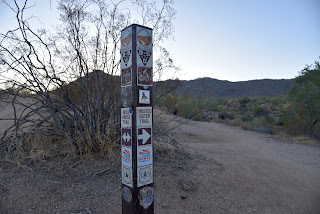
Hawes Trails are well signed

The trek begins with a short walk on the Bush Lite West trail to connect with the Wild Horse Trail that’s part of the Valley-circling Maricopa Trail. 
The green corridor of the Salt River from Wild Horse Trail

At the 0.2-mile point, Twisted Sister spins off to the right and begins its undulating run through saguaro-studded desert in the foothills below the Usery Mountains.  Once through a couple of slippery downhills and wash crossings the route trudges uphill, revealing grander views at each turn.  The massive form of 2,832-foot Red Mountain (also known as S-wegi Do’ag in O’odham, Wi:kawatha in Yavapai and Mount McDowell, Fire Rock and Gunsight Butte) is a constant presence on the west side of the river on the Salt River Pima-Maricopa Indian Community at the confluence with the Verde River.  To the north, iconic Four Peaks hover over the mountains of Tonto National Forest and on the distant west horizon, Camelback Mountain rises above city haze. After just under a mile of steady but not-to-tough climbing, the trail meets a three-way junction.
Saguaros and boulders on Big Sister Trail

Mountains of Tonto National Forest on horizon

For a short loop hike, veer left onto the Big Sister Trail.  Whereas Twisted Sister was all about views, Big Sister is all about rocks.  Clinging to boulder-strewn slopes, the slim path weaves through impressive globs of granite, boulder ridges and natural stone sculptures.  Midway through the 1-mile return leg, the trail gives up the widest-angle views of the Salt River Valley and on lucky days, grazing wild horses and vintage aircraft from The Commemorative Air Force Aviation Museum can be spotted flying overhead. 

LENGTH: 3.6 miles

RATING: moderate for hiking, difficult for bikes

ELEVATION:  1,387 – 1,793 feet

GETTING THERE:

From U.S. 60 in Mesa, take the Power Road exit 188 and continue north (Power Road turns into Bush Highway) to the Wild Horse trailhead on the right between mile posts 23 and 24.

INFO:

https://www.fs.usda.gov/tonto

https://hawestrailalliance.com/


Monday, December 4, 2017

Wild Horse-Maricopa Trail Usery Mountains Segment

Wild Horse-Maricopa Trail Usery Mountains Segment
Cholla cacti are abundant along the Wild Horse Trail
The Salt River Recreation Area north of Mesa is a well-known destination for kayaking, tubing, fishing and picnicking. Although there are also some hiking trails near the water, riverside commotion, noisy crowds, entry fees and mounds of trash left behind by careless day trippers are buzz kills for trekkers in search of beauty and solitude. However, a nearby system of trails that overlooks the area offers peaceful wandering. 
Four Peaks as seen from the trail.
The Sonoran Desert (Hawes) Trail System in Tonto National Forest has more than 20 miles of interconnected paths located between Usery Pass Road and Bush Highway just south of the popular recreation area.  The northern-most route in the system is the Wild Horse Trail which is also part of the Valley-circumnavigating Maricopa Trail. As its name suggests, the trail passes through the domain of wild horses. 
Saguaro skeletons add interest to the hike
The elegant and sometimes controversial beasts can be spotted wading in the river, poking around in the riparian corridors and grazing in the surrounding desert foothills.  Regardless of where you might see them, it’s smart to keep your distance and enjoy the herds from afar.  The Wild Horse/Maricopa Trail escapes the din of the crowds and  is also high enough in the hills to afford inspiring vistas of the Salt River Valley, Four Peaks, Red Mountain and the Usery Mountains. Staring from the trailhead on Usery Pass Road, the trail heads out through wide washes and scoured gullies. You’ll cross an old “NRA pit” where rusting bullet casings, broken glass and other relics of target shooting activities remain in the sandy, buffered depression.
Overlooking the Salt River Valley
Shooting is no longer allowed there, but the sounds of gunfire can be heard from the Usery Mountain Shooting Range to the south.  Once through the pit area, the pop-pop of rifles and revolvers is muffled by a corrugated terrain of arroyos, ravines and gently rolling hills. Beyond the half-mile point, the hike takes on a surprisingly remote feel. The green band of the Salt River snakes through a chiseled landscape to the north, then arches south where it wends around Red Mountain in the Granite Reed Dam area.  The trail bears the hallmarks of its mountain biker origins. 
View of the Salt River near Bush Highway
Hairpin turns, swooping stretches and lots of swift-and-smooth roller coaster segments make for an ever-changing hike with surprises around every bend.  What little shade the trail has is provided by pockets of ironwood and Palo Verde trees that thrive in water-whittled ravines.  Another noteworthy botanical attraction here is a smattering of saguaro cacti skeletons in various stages of decomposition.  
A brief section with shade

Their woody cores with sponge-like patterns and haunting postures lie bare the internal structure of Arizona’s iconic plant.  The Wild Horse Trail ends at the 3.3-mile point but you can continue hiking on the Maricopa Trail for another 4.2 miles to Bush Highway for watery views and the best chance to see mustangs in the mist.
 Maricopa Trail and Wild Horse Trail follow the same route
LENGTH: 3.3 miles one way for Wild Horse Trail or 7.5 miles one way for Maricopa Trail section to Bush Hwy.
RATING: easy
ELEVATION:  1320' - 1880'
GETTING THERE:
From US 60 in Mesa, take the Ellsworth Road exit 192 and go 9 miles north (Ellsworth turns into Usery Pass Road) to the Wild Horse trailhead on the left. The trailhead is marked by a Maricopa Trail sign and a no-shooting post. There’s space for about 6 vehicles in the dirt turnout parking area.
Red Mountain 
Maricopa Trail:
Maricopa Trail & Park Foundation
Global Bikes Sonoran Desert (Hawes) Trail System Maps

Monday, December 1, 2014

VINEYARD TRAIL


VINEYARD TRAIL
Tonto National Forest
Roosevelt Lake 

At the north end of Roosevelt Lake, an elegant suspension bridge that straddles the gap between the Superstition Mountains and Four Peaks Wilderness serves as the gateway to Passage 20 of the Arizona Trail. This 19.5-mile   stretch of rugged roads and narrow footpaths shimmies through of some of the state's most spectacular country.   For a relatively short hike, this one really packs a scenic punch and a grueling climb at the start adds satisfaction to the vistas that unfold on the way up. The heart-pumping initial ascent along Inspiration Point tops out at 1.5-miles with 360-degree views of the lake, Sierra Ancha Mountains and green floodplains of Tonto Basin. From here, the hike is tempered by rolling grasslands as it moves west  toward Four Peaks.
View of Four Peaks
Roosevelt Lake and the Tonto Basin
Next, get your camera ready because the trail curves around a low slung, saguaro-populated ridge where the Salt River gorge and snaking form of Apache Lake shimmer a thousand feet below. This is one of the prettiest places in central Arizona. Beyond the river-and-lake eye candy, the trail dips down though rock fall and cacti to meet Forest Road 429 and the end of trail #131 at the Mills Ridge Trailhead where you can backtrack for a 9-mile day hike or continue 469 miles north to Utah on the Arizona Trail.
Salt River below
The old 4.5-mile Vineyard Trail #131 that was once used to service a reflector on a pinnacle above the lake has been harnessed into this section of the AZT's state-traversing course.
LENGTH: 4.5 miles one way
RATING: difficult
ELEVATION: 2,200' - 3,700'
GETTING THERE:
The trailhead is located on the northeast side of the Roosevelt Dam Bridge and can be accessed via State Routes 188 and 88. There are several ways to get there from Phoenix including the shortest route that's a precipitous drive on the rough dirt mountain grades of SR88.  But the faint of heart should instead take State Route 87 north to the SR188 junction and head 30 miles south to the trailhead parking turnout at the big Arizona Trail sign on the left just before the bridge. The hike begins across the road at the AZ88 junction sign.
INFO: Arizona Trail Association:
Tonto National Forest: Tonto Basin Ranger District, 928-467-3200
MORE PHOTOS:

Sunday, November 23, 2014

SONORAN DESERT (HAWES) TRAIL SYSTEM


SONORAN DESERT (HAWES) TRAIL SYSTEM
Tonto National Forest, Mesa Ranger District
Salt River viewed from Saguaro (aka Mine) Trail

Originally constructed by mountain bike enthusiasts, this intertwining system of trails overlooking Granite Reef Dam on the Salt River in Mesa is just too interesting for hikers to ignore.  In 2005, 10.3 miles of the 20-mile web of social trails were adopted into the Tonto National Forest System. As would be expected of bike trails, these routes offer an entertaining mash up of twists and swooping turns tracing the site’s hills and valleys. The 5-trail maze is also known as the "Hawes System" after the longest route in the mix. As bikers heavily use these trails, hikers should stay alert and share the dirt accordingly. Trail courtesy dictates that bikers yield to hikers and everybody yields to horses---especially the wild mustangs that roam this riverside terrain. However, a bike careening through a hairpin turn at break neck speed won't necessarily be able to avoid you without drawing blood. So, although riders on these trails are generally courteous and careful, be prepared to relinquish the right of way whenever possible---after all, they were here first.
LENGTH: 10.3 miles (maintained trails only)
Hawes Trail #52: 3.4 miles
Ridge Trail #59: 1.7 miles
Granite Trail #54: 0.7 mile
Saguaro Trail #50: 3.1 miles
Saddle Trail #51: 1.4 miles
RATING: moderate
ELEVATION: 1150’ – 1760’
GETTING THERE:
From Phoenix go east on Loop 202 to exit 23 for Power Road in Mesa.  Travel 2.1 miles north on Power Road to the Hawes Trailhead on the left. Trail begins across the road.
INFO & MAPS: Global Bikes
Tonto National Forest
MORE PHOTOS:

Sunday, November 16, 2014

BUTCHER JONES TRAIL


BUTCHER JONES TRAIL
Saguaro Lake
Trail near Camper Cove

Of the sting of reservoirs tethered by the Salt River 30 miles northeast of the Valley, amenity-rich Saguaro Lake is the closest and easiest to find. This is one of the reasons why it's so wildly popular for boating, fishing or simply bonding with a cooler and juicy novel under a lakeside mesquite tree. Hikers can hit the dirt here by way of the Butcher Jones Trail that wraps around a water-piercing peninsula with secluded coves. Most of the route hugs the cliffs high above the lake, but fisherman paths to the shore make nice scenic detours for photography, wildlife spotting or a cozy lunch break. The trail's high points reveal fantastic views of the gaping Salt River Canyon, 1930s-era Stewart Dam and surrounding mountain ranges. Arrive early to get a good parking spot and be prepared to share the trail with pole-toting anglers and gaggles of kids running off their hot dogs and Kool-Aid. If noise and crowds cramp your style, hang in there---the commotion dissipates where the trail makes a hairpin turn around Peregrine Point.
LENGTH: 5 miles roundtrip
RATING: moderate
ELEVATION: 1529' - 1600'
FACILITIES: restrooms, picnic tables
FEE: Tonto Pass is required. $6 daily fee
GETTING THERE:
From Mesa, go 27 miles north on SR87 (Beeline Highway) to exit 199, Bush Highway (FR204), turn right and continue 2 miles to the signed turnoff for Butcher Jones Recreation Area.  Follow the access road (FR116) 2 miles to the site.  Trail begins at far east end of the beach.
INFO: Tonto National Forest
MORE PHOTOS:

Monday, October 27, 2008

RIO SALADO

RIO SALADO HABITAT RESTORATION PROJECT Just two miles south of downtown Phoenix, where the Salt River once flowed, a former dumping ground has been transformed into a thriving 595-acre oasis in the desert. With the cooperation of the Army Corps of Engineers, the Flood Control District of Maricopa County and droves of volunteers, tons of waste were cleared out of the Salt River channel and replaced with ponds, waterfalls and tens of thousands of indigenous plant species. Although the 5-mile-long strip of riparian habitat looks as if it occurred naturally, it’s actually a “demonstration wetland” that was created by tapping into the groundwater beneath the river channel and pumping more than 2.65 million gallons of water per day to sustain the habitat. Stretching from 19th Avenue to 16th Street, the project is a work in progress. The Central Avenue gateway is currently the most complete segment and there’s parking, interpretive signage, restrooms and drinking water. Trail segments are organized to feature specific desert habitats such as Cottonwood-Willow, Lower Sonoran, Mesquite Bosque and Palo Verde. Although just a few years old, the plants—which were harvested from seeds or cuttings within a half-mile of the Salt River—are already flourishing and attracting wildlife. Snowy Egrets, raptors, toads and dozens of other species have settled in. Future plans for the project include adding more gateways to access the more than 10 miles of paved and dirt trails and an Audubon Nature Center. LENGTH: about 10 miles of paved and dirt trails are planned. As of 0506, about 3 miles of established trails are open. RATING: easy and informative ELEVATION GAIN: 50 feet GETTING THERE: From Phoenix. Drive south on Central Avenue through downtown. Just past the I-17 underpass, look for the obvious parking area on the leftAlternate routes: From the east Valley, take Highway 60 west and connect to I-17. Exit I-17 at 7th Street. Go south on 7th Street to Broadway Road. Turn right (west) on Broadway Road and continue to Central Avenue. Turn right onto Central Avenue and head north for about 1 mile to the gateway. From the west Valley, take I-10 to I-17 and exit at 7th Avenue. Go south on 7th Avenue to Broadway Road. Turn left (east) onto Broadway Road and go to Central Avenue. Turn left (north) onto Central Avenue and continue for about a mile to the gateway on the right.

COON BLUFF

COON BLUFF Tonto National Forest Sunrise over Coon Bluff is sometimes greeted by a herd of wild mustangs wandering on the shores of the Lower Salt River. Early morning is the best time to sight the horses and a seat on top of Coon Bluff offers the best vantage point for viewing the elusive beasts. Coon Bluff’s rugged escarpment flanks the river and is one of several scenic high points along a maze of unofficial trails that meander through the desert terrain above the confluence of the Verde and Salt Rivers. To reach the bluff, just follow the wide paths uphill and take your pick of the many options along the ridges. There are several spur trails that lead down to the water. There, water birds and raptors chatter in the mesquite trees that thrive along the sandy shore. Although sighting a bald eagle or a turkey vulture is pretty common, catching a glimpse of the mustangs requires more patience. On days when they show up, they appear like ghosts and then disappear back into the desert in a flash of commotion that leaves behind hoof prints and a cloud of dust. LENGTH: 3 miles round trip RATING: moderate ELEVATION : 1,486' - 1,593' GETTING THERE: From Phoenix, go east on US 60 to the Power Road exit. Continue north on Power Road, which will turn into the Bush Highway, and then turn left on the Phon D. Sutton Recreation Site Road (Granite Reef Dam Rd). Drive about 100 feet and park in the corralled dirt lot just before the gate. The hike starts at the generic trail sign. INFO:  Mesa Ranger District, Tonto National Forest, 480-610-3300
http://www.fs.usda.gov/wps/portal/fsinternet/!ut/p/c5/04_SB8K8xLLM9MSSzPy8xBz9CP0os3gDfxMDT8MwRydLA1cj72BTSw8jAwgAykeaxcN4jhYG_h4eYX5hPgYwefy6w0H24dcPNgEHcDTQ9_PIz03VL8iNMMgycVQEAIzTHkw!/dl3/d3/L2dJQSEvUUt3QS9ZQnZ3LzZfME80MEkxVkFCOTBFMktTNUJIMjAwMDAwMDA!/?ss=110312&ttype=recarea&recid=35399&actid=43&navtype=BROWSEBYSUBJECT&position=BROWSEBYSUBJECT&navid=110190000000000&pnavid=110000000000000&cid=FSE_003723&pname=Tonto+National+Forest+-+Coon+Bluff