From the drive in to the trailhead to its
turnaround point, this hike is packed with stunning scenery. Hedged among rough
cut cliffs and desert highlands of the Verde River watershed, Bartlett
Reservoir fills 12 miles of the canyon bound channel with crystalline waters teeming
with bass, catfish and bluegills. Although the year-round recreation site which
is located roughly 50 miles north of Phoenix is famous mostly for its boating,
fishing, shaded picnic areas and camping opportunities, the Palo Verde Trail
offers hikers a surprisingly challenging route with terrific mountain and water
views. The trail meanders among the foothills and washes on the lake’s western
banks. This is not a hike to try during or immediately after storms because
rain rumbling off the foothills turns washes and gullies into raging rivers of
debris.
 |
| Chollas frame Tonto National Forest mountain vistas |
Don’t be fooled by the hike’s
minimal amount of elevation change---the trail is a deceptively convoluted
series of twists, steep climbs and slippery descents on a base of crumbling
granite and sand. Overall, you will have accumulated 900+ feet of elevation
gain over the 9.4-mile, out-and-back trek.
The trail wastes no time getting you up into the hills above Rattlesnake
Cove for breathtaking vistas of the distant peaks of the Mazatzal Wilderness
and fire tower-capped Mount Ord. Across the water, the hulking profiles of
Maverick and SB Mountain in Tonto National Forest bolster the reservoir’s 33
miles of shoreline casting shadows on peninsulas and islands that morph in size
with water levels.
In springtime, these
hills are ablaze in wildflower glory. Look for desert lavender, chuparosa,
brittlebush, Mexican gold poppies, filaree, lupines and blooming cholla and
saguaro cacti.
 |
| Rattlesnake Cove |
Beyond the marina at near
the 3-mile point, the trail splits. The path to the left is a spur that shaves
a mile off the route. To the right, the main trail makes a hairpin loop among
deep washes, quartz mounds and areas of washouts that make the route somewhat difficult
to follow. Strategically-placed rock barriers and cairns mark the way. Soon,
you’ll reach the beachy inlet of SB Cove. Strewn with driftwood, this cozy
notch in the landscape is a favorite stomping ground for blue heron and
seasonal shorebirds. The route terminates a short walk from the SB Cove
Recreation Site. If you didn’t park a shuttle vehicle there, return the way you
came.
 |
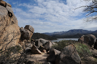
| Foothills of the Verde River watershed |
LENGTH: 4.7 miles one way or
3.7 with shortcut
RATING: moderate
ELEVATION: 1798’ – 1882’
From Loop 101 in Scottsdale,
take the Pima/Princess Drive exit 36 and go 13 miles north on Pima and turn
right on Cave Creek Road. Continue 4.1
miles to Bartlett Dam Road, turn right and go 12.6 miles to North Shore Road (Forest
Road 459). Turn left continue 0.6 mile to the turn off Rattlesnake Cove
Recreation Site (Forest Road 459A). Park at the last restroom at the south end
of the parking loop. Walk down the stairs behind the restrooms and head right
toward the trailhead sign.
FEE: A Tonto Pass is required
to park. $6 daily fee per vehicle.
INFO: Tonto National Forest


