Find A Trail. Start Your Search Here:

Showing posts with label High Desert Trail. Show all posts

Monday, August 22, 2022

High Desert Trail

HIGH DESERT TRAIL

Black Canyon City

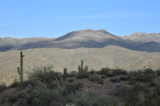
Bradshaw Mountains seen from High Desert Trail

Tethered to both a kiddie playground a backcountry historic trail, High Desert Park in Black Canyon City doubles up as an approachable community gathering space and gateway to the rugged canyonlands of Central Arizona.
Blooming barrel cactus on High Desert Trail

Dubbed a “Desert Gem” by the High Desert Helpers, Inc., the 501(3)(c) non-profit that manages the park and the High Desert Trail within it, the Yavapai County site packs a massive amount of fun into its 89.1-acre parcel.
Kings Canyon Overlook on the "blue" loop

The park is situated west of Interstate 17 among the suburbs of Black Canyon City, Rock Springs and the foothills of the Bradshaw and New River Mountains.

Swing sets, restrooms, water, picnic tables, grills, sports facilities and community center anchor the family-friendly plot while a total of 2.7 miles of outdoor trails offer non-intimidating ways to get some exercise.

A rabbit hops through a cholla forest

The High Desert Trail has two parts. The main “blue” trail is a 1.7-mile loop and the 0.3-mile “yellow” trail (also known as Joedy’s Trail) that may be used for a shorter loop option.

"Tablelands" stand out on the High Desert Trail

The hike begins at a shade pavilion with maps and interpretive signs describing local wildlife. Heading west for a counterclockwise hike is the preferred plan as it takes on the climbing section of the trail early on. Initially the trail moves through a cholla forest that’s part of the park’s 0.8-mile original nature trail that has been lassoed into the blue perimeter loop.

Junction of the "blue" and "yellow" trails

Hike begins in High Desert Park in Black Canyon City

 Rustic wood signs placed along the route identify native plants such as jojoba, barrel cactus and saguaros.  Right from the get go and throughout the hike, gorgeous mountain views and a tableland of flat topped mesas peek through cholla forests and thickets of diverse desert vegetation.
Desert senna blooms April - October

Quartz and basalt: part of the area's complex geology

Rusty artifacts on the "yellow" trail

The trail’s appeal is augmented with benches placed at scenic spots and two spectacular overlook points. A short spur trail leads to Kings Canyon Overlook, a stony edge on the far west end of the blue loop trail that hangs over the deep gorge of Black Canyon.
Monsoon rains coax the green out of ocotillo

At the south end of the perimeter loop, the Rock Springs Overlook peers over the severe cuts of the Agua Fria River channel, and the famous Rock Springs CafĂ©, pies and all. 
Rock Springs scenic overlook

The "yellow" trail cuts through the main "blue" loop

Never quite escaping the subdued rattle and hum of Interstate 17, the loop’s east leg dips downhill to meet a connector path that leads to a popular trailhead for the  Black Canyon National Recreation Trail—a long-distance, non-motorized historic route that goes from Phoenix to the Verde Valley. The final leg swings north through classic high desert eco zones and saguaro-lined ridges replete with a sampling of the quartz outcroppings, metamorphic stone slabs and volcanic ejecta that contribute to the area’s complex geological footprint, completing a fun and informative trek lodged between freeway and wilds.
Spectacular mountain views dominate the hike

LENGTH: 2.1 miles (blue and yellow trails)

RATING: moderate

ELEVATION:  2,024 – 2,153 feet   

GETTING THERE:

19001 Jacie Lane, Black Canyon City.

From Interstate 17, take the Black Canyon City/Rock Springs exit 242. Turn left at the stop sign, then right at the Old Black Canyon Highway junction. Continue a short distance  to Jacie Lane, turn left and follow the road into the park.

PARK HOURS: Dawn to dusk daily

FACILITIES: restrooms, water, picnic tables & grills, sports facilities, kiddie playground

INFO:

Yavapai County Parks

yavapaiaz.gov/facilities/yavapai-county-parks/high-desert-park

High Desert Helpers, Inc.

highdeserthelpers.org/park/


Monday, October 17, 2016

RENEGADE TRAIL

RENEGADE TRAIL

McDowell Sonoran Preserve
Massive granite boulders flank Renegade Trail
In many ways, hiking is a renegade sport. Rebellious souls who answer the call of the wild grow impervious to heavy packs, sore feet, gross food, weather and self doubt. They pee in the forest and sleep on the ground while working around physical obstacles and an array of toxic plants and poisonous critters. To the hiker-at-heart, this is fun. So it's fitting that a new trail in Scottsdale's McDowell Sonoran Preserve pays homage to those who approach the trails unwashed, unshaven and living the dream. Renegade Trail is just one example of the preserve's route monikers that embrace our Western heritage with seasonings of humor and irony. Examples include, Wrangler, Rustler, Buckshot, Cow Poke and the crown jewel--Whiskey Bottle. Kudos to the preserve's naming committee which I imagine conjure these names over beers at a honky tonk.
A blind corner on Desperado Trail
Tucked into the preserve's northeast corner, Renegade Trail rumbles through a mix of wide open spaces and boulder-choked passages miles from established trailheads. The primary reward of hiking the extra miles to reach this route is escape from the crowds that tend to wander the curiosity-rich trails to the south. Quieter surroundings make for better opportunities to spot the Red-tailed hawks, ravens, coyotes and reptiles that disappear among the area's rocky crevasses when human traffic is high. Like all trails in the preserve, there's more than one way to incorporate the Renegade Trail into a day hike.
The "Michelin Man" 
Here's one circuit that takes you through a gnarly bike path and a scenic box canyon with swings around a "Michelin Man" cactus and a magnificent crested saguaro.
HIKE DIRECTIONS:
Big desert views on Renegade Trail
From the trailhead, follow the 136th Street Trail 2.2 miles north to the Renegade Trail junction. Follow Renegade 2.1 miles to where it ends at High Desert Trail. Backtrack 0.7 mile, veer right onto Desperado Trail and follow it 0.5 mile to Coyote Canyon Trail. Turn left, hike 0.5 mile and head right on Dove Valley Trail. Follow DVT 1 mile to 136th Street Trail, go right and hike 1.3 miles back to the trailhead.
LENGTH: 8.3 miles round trip
RATING: moderate
ELEVATION: 2,614' - 2,849'
GETTING THERE:
Granite Mountain Trailhead
31402 N. 136th St. Scottsdale.
From Loop 101 in Scottsdale, take the Princess/Pima exit #36 and go 6.5 miles north on Pima to Dynamite Blvd./Rio Verde Dr. Turn right and continue 5.9 miles to 136th St., turn left and go 1.8 miles to the trailhead on the left. Trailhead is open sunrise to sunset. No facilities.

Monday, October 19, 2015

BUCKSHOT-HAWKNEST CIRCUIT

BUCKSHOT-HAWKNEST CIRCUIT
McDowell Sonoran Preserve, North
Buckshot Trail

I have a new favorite trail in Scottsdale's McDowell Sonoran Preserve. Again. This happens every time I overcome my penchant for hiking well-known long paths with spectacular scenery and try something different. Although it's only 0.8-mile long, Buckshot Trail wins laurels because it straddles the gap between the familiar and the untried. It shoots off from the heavily travelled Brown's Ranch site to connect with the newer Hawknest Trail that arches over the preserve's north section for nearly its entire width. On the day I discovered this desert jewel, a huge group of hikers was assembled at the trailhead preparing to trek the 7.7-mile Cholla Mountain Loop--one of the area's most scenic circuits. They invited me to join them, but the drone of "been there done that" rattling in my cerebellum won over and I plowed north toward new-to-me territory instead. As with all hikes, trying to comprehend the unique character and secrets of an unexplored trail by viewing it as a line on a map is kind of like presuming to know the traits of a wine without having tasted it. Will it be a nobel Grand cru or some pedestrian vin du pays? The essence of the Buckshot Trail falls somewhere between Night Train and a hoity toity Bordeaux--amusing yet rich. Packed with massive saguaros, blooming shrubs and yucca-framed vistas, it's just far enough off the beaten paths to offer savory solitude. Only one other hiker (a preserve steward) and a handful of mountain bikers, crossed my path. Excellent maps available online and at the trailhead show numerous ways to cobble your own circuit using Buckshot Trail. Here's the route I took: From the trailhead, hike 1.9 miles north on Brown's Ranch Road to marker CL6 and turn right onto Corral Trail (note, this is 0.6 mile beyond the first Corral Trail access point). Go 0.5 mile on Corral, turn left on the Buckshot Trail and continue 0.8 mile to Hawknest Trail. Turn right (north) at the sign and hike 1.5 mile to Broken Spoke Trail, turn left and go 0.6 mile to High Desert Trail. Turn right (south) and go 0.7 mile to Corral Trail and follow the signs back to the trailhead.
On the return leg of the trip, solitude evaporated as I encountered some of the Cholla Mountain group and dozens of other hikers funneling onto arterial Brown's Ranch Road for the final mile-long trudge back to civilization and perhaps a nice Chianti.
LENGTH: 8.8 mile loop
RATING: easy
ELEVATION: 2,610' – 2,770'
HOURS: sunrise to sunset daily
GETTING THERE:
Brown's Ranch Trailhead
30301 N. Alma School Road, Scottsdale.
From Loop 101 in Scottsdale, take the Pima/Princess exit 36, go 6.5 miles north on Pima to Dynamite, turn right and continue 2.7 miles to Alma School Road. Turn left and continue 1 mile to the trailhead. There are restrooms, water and maps at the trailhead. No fee.
INFO: McDowell Sonoran Preserve
http://www.scottsdaleaz.gov/Assets/ScottsdaleAZ/Preserve/Preserve+North+Area+Trail+Map.pdf
MORE PHOTOS: