HIGH DESERT TRAIL
Black Canyon City
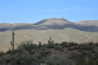
Bradshaw Mountains seen from High Desert Trail
Tethered
to both a kiddie playground a backcountry historic trail, High Desert Park in
Black Canyon City doubles up as an approachable community gathering space and
gateway to the rugged canyonlands of Central Arizona. Blooming barrel cactus on High Desert Trail
Dubbed a “Desert Gem” by
the High Desert Helpers, Inc., the 501(3)(c) non-profit that manages the park and
the High Desert Trail within it, the Yavapai County site packs a massive amount
of fun into its 89.1-acre parcel.Kings Canyon Overlook on the "blue" loop
The park is situated west of Interstate 17 among the suburbs of Black Canyon City, Rock Springs and the foothills of the Bradshaw and New River Mountains.
Swing sets,
restrooms, water, picnic tables, grills, sports facilities and community center
anchor the family-friendly plot while a total of 2.7 miles of outdoor trails offer
non-intimidating ways to get some exercise. A rabbit hops through a cholla forest
The High
Desert Trail has two parts. The main “blue” trail is a 1.7-mile loop and the
0.3-mile “yellow” trail (also known as Joedy’s Trail) that may be used for a
shorter loop option. "Tablelands" stand out on the High Desert Trail
The hike
begins at a shade pavilion with maps and interpretive signs describing local
wildlife. Heading west for a counterclockwise hike is the preferred plan as it
takes on the climbing section of the trail early on. Initially the trail moves
through a cholla forest that’s part of the park’s 0.8-mile original nature
trail that has been lassoed into the blue perimeter loop.Junction of the "blue" and "yellow" trails Hike begins in High Desert Park in Black Canyon City
Rustic wood signs placed along the route identify
native plants such as jojoba, barrel cactus and saguaros. Right from the get go and throughout the hike,
gorgeous mountain views and a tableland of flat topped mesas peek through
cholla forests and thickets of diverse desert vegetation. Desert senna blooms April - October Quartz and basalt: part of the area's complex geology Rusty artifacts on the "yellow" trail
The trail’s appeal is
augmented with benches placed at scenic spots and two spectacular overlook
points. A short spur trail leads to Kings Canyon Overlook, a stony edge on the
far west end of the blue loop trail that hangs over the deep gorge of Black
Canyon.Monsoon rains coax the green out of ocotillo
At the south end of the perimeter loop, the Rock Springs Overlook peers
over the severe cuts of the Agua Fria River channel, and the famous Rock
Springs Café, pies and all. Rock Springs scenic overlook The "yellow" trail cuts through the main "blue" loop
Never quite
escaping the subdued rattle and hum of Interstate 17, the loop’s east leg dips
downhill to meet a connector path that leads to a popular trailhead for the Black Canyon National Recreation Trail—a long-distance,
non-motorized historic route that goes from Phoenix to the Verde Valley. The
final leg swings north through classic high desert eco zones and saguaro-lined
ridges replete with a sampling of the quartz outcroppings, metamorphic stone
slabs and volcanic ejecta that contribute to the area’s complex geological
footprint, completing a fun and informative trek lodged between freeway and wilds.Spectacular mountain views dominate the hike
LENGTH: 2.1 miles (blue and yellow trails)
RATING: moderate
ELEVATION: 2,024 – 2,153 feet
GETTING THERE:
19001 Jacie Lane, Black Canyon City.
From Interstate 17, take the Black Canyon City/Rock Springs exit 242. Turn left at the stop sign, then right at the Old Black Canyon Highway junction. Continue a short distance to Jacie Lane, turn left and follow the road into the park.
PARK HOURS: Dawn to dusk daily
FACILITIES: restrooms, water, picnic tables & grills, sports facilities, kiddie playground
INFO:
Yavapai County Parks
yavapaiaz.gov/facilities/yavapai-county-parks/high-desert-park
High Desert Helpers, Inc.


No comments:
Post a Comment