Find A Trail. Start Your Search Here:

Showing posts with label East Clear Creek. Show all posts

Monday, July 10, 2023

Forest Road 6033C

INTO THE WOODS on FOREST ROAD 6033C

FR6033C on the Mogollon Rim

Forest roads can be sweet escape routes from the swarms of summertime recreationists that migrate from the Valley to the cool Arizona high country. Especially the ragged ones; the ones few people notice or care to explore. This is a boon for intrepid types willing to walk out into the albeit signed and plowed unknown.

McCarty Ridge seen from FR6033C

Forest Road 6033C reveals no obvious destination, its purpose is veiled in a tangle of pines.

A drought-stricken wildlife water hole on FR6033C

The backwoods road located a couple clicks north of the community of Clints Well on the Mogollon Rim is signed but not shown on forest service maps.   It runs on the terraced slopes above the course of East Clear Creek in Coconino National Forest west of the popular Blue Ridge recreation area and C.C. Cragin Reservoir.
Several side roads offer more exploratory options

Passage 27 of the Arizona National Scenic Trail winds over Battleground Ridge through the busy hot spot on its way north to Utah. Camper convoys, boat trailers and conga line of backpackers and day hikers speak to the area’s magnetism for heat-weary outdoor enthusiasts.  With so many rich hiking opportunities nearby, the logic for walking on a non-descript dirt road lands squarely between why and why not.
Kaibab pussytoes bloom May - July

The FR6033C hike is clocked from a gate just beyond the dispersed camp sites on Forest Road 9033H.  Within a half mile, the road meets its first junction where FR6033C continues left.  From the junction, the deeply rutted track is an endless series of ups-and-downs that hop drainages, draws and ridges, accumulating over 1,000 feet of elevation change. For a mind-clearing, uncrowded excursion, there aren’t many distractions. 

A horned lizard vogues for the camera

A wildlife water tank and several signed side roads that appear to disintegrate a few yards in are the only disrupters in an environment dominated by Ponderosa pine trees with their signature straight-arrow trunks and rounded canopies.  Forest water tanks are often dry in summer before the monsoons kick in, putting wildlife at risk. Arizona Game & Fish Department receives no general fund tax dollars to  maintain 3,000 wildlife waters including created catchments around the state and relies on donations to deliver life-saving water to drought-stressed locations. (Not necessarily the water hole shown here.)
Solitude not far from popular recreation sites

You can help by donating at azwildlifehero.com.

At the top of several rises, conifer-fleeced McCarty Ridge cuts a prominent profile on the southeast horizon. Except for wind-rustled branches and the scurrying of critters, it’s blissfully quiet. At the 2.5-mile point, in a shaded hallow, the road veers north and becomes sketchy enough to call it a turnaround point.

LENGTH: 5 miles round trip

RATING: moderate

ELEVATION: 6,894 – 7,132 feet (1,107 feet of elevation change)

GETTING THERE:

From the State Route 87/260 junction in Payson, go 40 miles north on SR87 (past Clints Well) to Forest Road 9033H on the right past milepost 292.

SEND WATER:

Arizona Game & Fish Department

Wildlife Hero Program

https://www.azwildlifehero.com/programs/lifesaving-water?gad=1&gclid=EAIaIQobChMI_7rjkcSEgAMVfg-tBh2KdgcnEAAYASAAEgKf7PD_BwE


Sunday, August 18, 2013

POVERTY DRAW & KEHL CANYON


POVERTY DRAW & KEHL CANYON
Mogollon Rim

Typical trail condition

Forest roads have always been open to hikers for easy treks.  Now that the forest service has been closing less-used roads to motorized traffic to allow soils, plants and wildlife habitats to recover, these eroding ruts have found second lives as footpaths.  Forest Road 147E is one of those routes.  Located on the Mogollon Rim near Potato Lake, this former Jeep two-track provides easy access to East Clear Creek and the upper portion of Kehl Canyon.  Although it will be decades before roads like this one are totally absorbed into the wilds,
Moist & mossy
they still provide authentic outdoor experiences.
For this adventure, there’s no officially numbered hiking trail, however, the route is not too difficult to navigate.  Here’s the plan:
From the parking area, begin hiking on FR147E. This dirt road parallels Poverty Draw, which runs off to the left. Well equipped, experienced hikers can drop into the draw and pick through a maze of brush and pools for 1 mile to East Clear Creek, but the easy way is to walk on FR147E to the 0.9-mile point where a barbed wire fence blocks the road. Do NOT pass through the fence—instead, head left following the wire line to a primitive entry in the barbed wire. Cross the fence (leaving it the way you found it) and hike downhill on a rudimentary path to East Clear Creek. Cross the creek and hike east (straight ahead) aiming for the washed out embankment.  Head right (south) and follow the decommissioned 4x4 road into Kehl Canyon. After roughly 1mile, the road makes a sharp right turn up a bank.  Here is where you’ll leave the road and head left to stay in Kehl Canyon.  If you thought the hike up to this point was amazing---just wait, it gets even better. From this point on, contorted sandstone escarpments and old growth coniferous forests close in on the moist and lush canyon. Sturdy boots, long pants and hiking sticks are required to get through the rock barriers, logs, brush, water-carved caves and a Technicolor show of marsh-loving wildflowers.  The canyon snakes four miles southward to Rim Road and Kehl Springs campground.  However, the going gets challenging at the 2.6-mile point, where a quagmire of deadfall, boulder-choked washes, and narrow passages will slow your pace and tax your problem-solving skills.

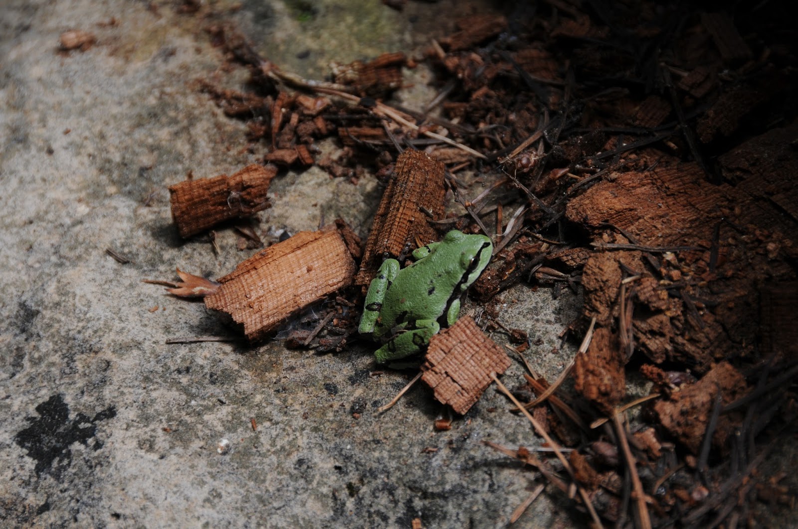
Our state amphibian: Arizona tree frog

LENGTHS:
FR147E to East Clear Creek: 1 mile.
Kehl Canyon turn off to Rim Road: 4 miles (difficult after 1.2 miles)
RATING:  moderate-difficult (route-finding, rough terrain)
ELEVATION: 6986' - 7420'
GETTING THERE:
From the State Route 87/260 intersection in Payson, continue north on SR87 to Forest Road 147 just north of milepost 287. Turn right and go 2.5 miles on FR147 to FR147E (past Poverty Spring) on the left.  Park here.

Tuesday, August 28, 2012

Horse Crossing Trail


HORSE CROSSING TRAIL
Coconino National Forest

A leisurely amble through the pristine and complex canyon system of upper East Clear Creek reveals wonders that even the most well traveled Arizona hikers will find astounding. There’s the epic views from the coniferous forest rim, a scenic drop into the canyon along a fossil-encrusted limestone trail, and an emerald-green riparian environment along the water.
Sandwiched between two reservoirs, East Clear Creek slices into soft sedimentary pediments leaving behind a meandering sheer-walled canyon.  This 50-mile-long ribbon of life-giving water flows northeast from Blue Ridge Reservoir to Clear Creek Reservoir near Winslow where it merges with the Little Colorado River. 
Although traversing the entire length of this gorge would involve technical climbing skills, swimming and rafting, all that’s needed to hike the Horse Crossing trail #20 is a pair of boots and a day pack.  Exploring the mid-section of the creek, Horse Crossing is hemmed in by hard scramble rock escarpments.  At the bottom of the canyon, running water sculpts sandstone walls that look like dunes tilted on their sides in layer-cake formation.  Tens of millions of years ago, the landscape surrounding East Clear Creek was part of a vast ocean and the fossilized remains of sea-dwelling algae, coral and brachiopods are strewn about like scattered bones.  Like all of the “crossing” trails on the Mogollon Rim, this one continues up the opposite side of the canyon. However, it’s more fun to bush whack and wade for several miles up or downstream where clouds reflected in mirror-like pools in the worn sandstone gives the impression of walking on the sky. 2018 UPDATE: Fire damage in the area, travel with caution.


LENGTH: 3 miles round-trip
RATING: moderate
ELEVATION: 6,900’ – 6,400’
DISTANCE FROM PHOENIX: 170 miles one-way
GETTING THERE:
From Payson, travel north on State Route87 to Clints Well.  From there, continue on SR 87 for another 9.4 miles to the turn off for Forest Road 95 (between mileposts 299 and  300).  Turn right (east) on FR 95 and drive 4 miles to Forest Road 513B.  Go left (east) on FR 513B and continue 2 miles to the trailhead.  A high-clearance vehicle is required on FR 513B.


Sunday, August 19, 2012

Water and wildflowers on the Mogollon Rim


JONES CROSSING


Now here’s a little slice of paradise wrapped in fragrant pines and wildflower glory. The water of East Clear Creek nourishes a sweet ribbon of green across the Mogollon Rim and a hike into the beautiful Jones Crossing area of this perrenial stream rewards with exposure to an impossibly lush canyon flanked by contorted limestone cliffs. The trek begins at Jones Crossing bridge where hikers can follow the stream either north or south.  We found the southbound strip more scenic and better shaded.  Right out of the chute, the route---which roughly follows a closed 4x4 road----drops hikers into a field of thigh-high grasses splattered with OxEye Daisies and wild geraniums.  From here, just follow the water to enter a steep-walled canyon with intermittent pools and trickling rivlets smothered in ferns and bobbing yellow Columbine. Water levels fluctuate so be prepared for wet feet as there are a few spots where crossing does require some ankle-deep wading. 

LENGTH: 
Southbound (as described here): whatever---but it’s 5.2 miles one-way to the Poverty Draw side canyon.
Northbound: whatever, but it’s 1.75 miles to an unsigned forest road
RATING:  easy, with several creek crossings
ELEVATION:  6,850’ – 7,050’
GETTING THERE:
From the intersection of State Routes 260/87 in Payson, go north on SR87 (Beeline Hwy) past Pine-Strawberry to milepost 289 and the sign for Jones Crossing and turn right onto Forest Road 141. Continue 4 miles east on FR141 to the (signed) Jones Crossing bridge and park along the road.  FR 141 is maintained dirt with just a few minor bumpy parts--okay for slowly driven sedans.
Hike begins across of the bridge at the yellow “area closed” and “732” signs.  The area is closed to all motorized vehicles, but hiking is okay.
MORE PHOTOS:

Thursday, July 22, 2010

MACK'S CROSSING

MACK’S CROSSING Coconino National Forest
TINDER FIRE 2018: This trail was impacted by the April 2018 Tinder Fire. It is within the closure area. Please check with the forest service for updates.  Since it was abandoned in the 1940s, the old road leading to Mack’s Crossing has disintegrated into a precipitous ledge overlooking a gaping gorge carved by East Clear Creek. Even though these rough conditions don’t deter brave souls in fishing-gear-laden ATVs from careening down the serpentine route-- hiking at a leisurely pace is the best way to savor the dramatic beauty of this canyon. The downhill trek to the creek begins on the sunny, summer-cabin-peppered lip of the Mogollon Rim, passing fossiliferous limestone outcroppings and a stand of elegant Arizona walnut trees before rounding a bend where grand views of the waterway 600 feet below grab the spotlight. Near the creek, thickets of wild roses, alders, and exotic wildflowers color the landscape serving up handy excuses to stop and take in the sights. Although the official trail ends where the road meets the sandy shore of the stream, opportunities for wading, swimming and fishing abound both up and downstream. LENGTH: 4 miles (on trail) ELEVATION: 6,250 – 6,860 feet RATING: moderate BEST SEASONS: April - November DISTANCE FROM PHOENIX: 165 mils one-way GETTING THERE: From the junction of AZ 87 and AZ 260 in Payson, go north on 87 past Clint’s Well to milepost 304.5 and turn right onto Enchanted Lane (Forest Road 319). Continue 0.2 miles to Green Ridge Dr., hang a right and go 0.5 miles to Juniper Dr. From here, turn right and go a short distance to Cedar Dr. and follow it to the “primitive road 137” sign. Park along the road—do not block private driveways. INFORMATION: refer to the Coconino National Forest map

Sunday, December 21, 2008

KINDER CROSSING

KINDER CROSSING Coconino National Forest
TINDER FIRE 2018: This trail was impacted by the April 2018 Tinder Fire and is within the closure area. Check with the forest service for updates. https://inciweb.nwcg.gov/incident/5763/


When dogs dream about hiking, images of Kinder Crossing dance in their heads. Tucked into a picturesque canyon with a perennial stream, this trail packs every imaginable doggie delight into a single water-themed hike. Scampering rock squirrels, taunting blue jays, jumping fish and leaping frogs give chase, inciting primitive stirrings in even the most sophisticated of city dogs. Sandy beaches along East Clear Creek beckon dig-happy hounds and a plethora of swimming holes stoke the canine “inner wild” into overdrive. But, from a dog’s point of view, the best part about this trail is that there are always other four-legged friends around to join in a serious romp. The creek is accessed via a steep, three-quarter-mile path that descends 500 feet along the crumbling, fossil-laden limestone walls of the canyon. As the trail nears the creek, the pine canopy melts into a lush green corridor of moisture-hungry willows, alders, brambles, wild geraniums and daisies. Once at the creek, recreational opportunities abound. Although the official trail (#19) crosses the water and continues up the opposite wall of the canyon, most hikers prefer to stay in the gorge and scout along the banks of the creek. While hikers may be overwhelmed by the exploratory options in the canyon, dogs, in their infinite wisdom, see the dilemma as a no-brainer and simply belly-flop into the nearest swimming hole. Highlights: Contorted sandstone cliffs, swimming holes and sandy beaches. LENGTH: 1.2 miles round-trip (on trail) RATING: difficult  ELEVATION: 7,000’ – 6,500’ Driving distance from Phoenix: 165 miles one-way GETTING THERE: From Payson, go north on State Route 87 to Forest Road 95, which is located roughly 10 miles north of Clints Well between mileposts 299 and 300. Turn right onto FR 95 and continue 4.5 mile to the turn off on the left for Forest Road 95T and follow the signs for just over a half-mile to the trailhead. A high clearance vehicle is required on FR 95T. Information:  fs.fed.us/r3/Coconino