Find A Trail. Start Your Search Here:

Friday, April 19, 2013

Hike around an iconic Sedona rock formation


LOWER CHIMNEY ROCK & SUMMIT ROUTE
Sedona
Chimney Rock

Next to Cathedral Rock, Chimney Rock is one of the most iconic sandstone formations in Sedona.  Visible from just about everywhere in downtown Sedona, this singular, russet pillar (actually three clustered spires) stands sentry beneath the cream-colored behemoth of 6355' Thunder Mountain (aka Capitol Butte). Soaring to 4995', this natural sculpture cuts an impressive silhouette because of how it's isolated along a limestone ridge.  However, even with two of Red Rock Country's most recognizable geological formations looming 
Little Sugarloaf
above the trail, it's the "baby sister"---4872' Little Sugarloaf---that gets all the attention on this hike because the route makes a wide loop around the layered cone of this mini-mount.  A wooden "summit" sign marks the start of an optional spur path to the top.  The worthwhile diversion is short but mostly on slick rock, so proceed with care.  From the summit, views stretch all the way to Prescott, Jerome and Flagstaff. 

LENGTH:  2.9 miles
Lower Chimney Rock Loop: 1.5-mile loop
Summit Route: 0.7 mile one-way
RATING: easy-moderate
ELEVATION: 4550' - 4600' or 4870' with summit
FEE: A Red Rock Pass is required.  $5 daily fee.
HOURS: dawn to dusk daily
Butterfly on cliff fendlerbush, April 2013

GETTING THERE:
From Phoenix, travel north on I17 to exit 298for AZ179, Sedona-Oak Creek.  Head west (go left) and continue to the "Y" intersection of AZ179 and AZ89A in Sedona.  Veer west (left) through the traffic circle and continue 3.2 miles on AZ89A to Dry Creek Road.  Turn right and go 0.4 mile to Thunder Mountain Road, turn right and go 0.5 mile to the Thunder Mountain trailhead on the left.
INFO:  City of Sedona
MORE PHOTOS:

Thursday, April 18, 2013

Urban exercise hike


ALVORD LAKE
Phoenix

It was one of those Saturdays.  You know, those sacrificial weekend days given to yard work. While out  rushing around to the various plant nurseries in the area, I came across Cesar Chavez Park.  Even though I've known about it for years, I never really considered it a hiking destination.  However, when curiosity got the better of me, I made a quick detour between chores and discovered a very pleasant walking path and an unexpected, welcome leg stretch. The park is packed with ammenities like swing sets for the kids and is also part of the Arizona Game & Fish Urban Fishing Program.  The easy, paved walking path circles the 25-acre lake and has nice views of South Mountain, the Estrella Mountains and  plenty of water fowl.


LENGTH: 1.1 mile loop
RATING: easy, paved, barrier-free
ELEVATION: 1012'
HOURS: 5:30 a.m. - 11:00 p.m.
FACILITIES: picnic tables, shade ramadas, boat ramp, fishing, playground, restrooms.

GETTING THERE:
From central Phoenix, go south to Baseline Road, go west to 35th Ave  turn south and follow the signs to Cesar Chavez Park at 7858 S. 35th Ave.
INFO:
City of Phoenix Parks & Recreation, 602-262-6111

Arizona Game & Fish Urban Fishing Program

Tuesday, April 16, 2013

An educational “add-on” hike


ELDEN PUEBLO
Flagstaff
Add caption

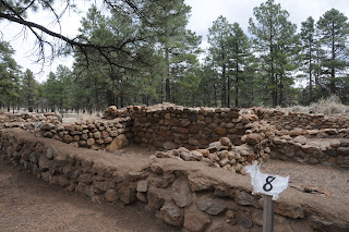
Once the meeting place of the Sinagua people, this archeological site located a few yards from busy AZ89 is now a major stop off for tourists, students and hikers alike. Brochures available at the trailhead correspond with numbered stops along the wide, flat gravel trail.  Each of the 15 sites tells a tale of life and culture in the village which at its high point was home to as many as 200 people.   Although short, plan on spending at least an hour to observe and read about the building techniques, life ways and archeological research.  A visit to this interesting roadside attraction is a good way to wind down after a longer hike in the area.

LENGTH: 0.1 mile loop
NEARBY HIKING TRAILS:
Old Caves Crater,
Elden Environmental Study Area,
Pipeline Trail,
Sunset Crater National Monument,
O'Leary Peak
RATING: easy, barrier-free (gravel)
ELEVATION: 6940'
HOURS: open year-round
FEES: none
GETTING THERE:
From Phoenix, go north on I17 to the I40 interchange in Flagstaff.  Head east (right, toward Albuquerque) and connect with AZ89 north.  Follow AZ89 to milepost 420 and start watching for the "Elden Pueblo" sign, which is just south of Townsend-Winona Road. Turn left and park in the gravel lot. 
INFO: Flagstaff Ranger District, Coconino National Forest
Elden Pueblo Program Manager: 928-527-3452

MORE PHOTOS:

Fisher Fire is 100% contained.


....close shave.  No word yet as to when Sandy's Canyon Trail will re-open.

From: "Magee, Brienne U -FS" <bmagee@FS.FED.US>
Date: April 16, 2013 3:04:11 PM PDT
To: <USDA-FS-NEWS@NEWSBOX.USDA.GOV>
Subject: SOUTHWESTERN-NEWS-RELEASE: Coconino National Forest
April 16 Update:
The Fisher Fire is 100% contained and 35 acres (slightly smaller size due to more accurate mapping last night). Cause is still under investigation. This was human caused, as there was not any lightning in the area, but specific cause has yet to be determined.

Brienne Magee
Public Affairs Specialist
Flagstaff Ranger District, Coconino NF
5075 N Hwy 89
Flagstaff AZ 86004
o: 928-527-8290

Monday, April 15, 2013

Fisher Fire update

UPDATE: 4-17-2013
Although the Fisher Fire has been declared "100% contained" as of yesterday afternoon, there's still no word as to when the Sandy's Canyon and AZT segment near Fisher Point will be re-opened.  Here's a link to the fire map:
http://azdailysun.com/map-of-fisher-fire/pdf_547c7218-a62e-11e2-bdbe-0019bb2963f4.html

Hikers, because Sandy's Canyon trail is one of my favorites,I've been following this fire very closely and will post forest service press releases as they send them to me.  Looks like fire fighters are making progress.....

Sandy's Canyon: fire was approximately here...

From: "Magee, Brienne U -FS" <bmagee@FS.FED.US>
Date: April 15, 2013 9:15:54 AM PDT
To: <USDA-FS-NEWS@NEWSBOX.USDA.GOV>
Subject: SOUTHWESTERN-NEWS-RELEASE: Coconino National Forest
April 15, 2013

           
Fisher Fire update, 8:30 a.m.

Flagstaff, Ariz. – The Fisher Fire crept and smoldered last night, but did not grow in size. Firefighters have a line around the fire and will continue to strengthen them today. Fire managers want to be sure lines hold through the high winds, however, before they declare an increase in containment.


Size: Approximately 40 acres
Containment: 50%
Location: near Fisher Point approximately four miles south of Flagstaff and two miles northeast of Lake Mary Road and the Canyon Vista Campground.
Date Reported: Saturday, April 13 at approximately 4pm
Cause: Human caused, under investigation
Resources: Approximately 100 personnel including four hotshot crews (Flagstaff Hotshots, Prescott Hotshots, Pleasant Valley Hotshots, and Blue Ridge Hotshots), engines, water tenders, a dozer and several overhead
Closures: The Sandy’s Canyon Trail and Arizona Trail at Fisher Point have been temporarily closed.

Smoke may be visible from the Flagstaff area and will drift to the east; expect smoke to be noticeable in Walnut Canyon, I-40, and the Continental Country Club area.

###

Sunday, April 14, 2013

Fire closes Sandy's Canyon & AZT near Fisher Point

FISHER FIRE UPDATE
Hi Hikers, well, we have our first trail-impacting forest fire of the season.  The human-caused Fisher Fire was reported yesterday.  Here's the forest service press release


Fisher Point

April 14, 2013          
Fisher Fire update, 10:30 a.m.
Flagstaff, Ariz.The Fisher Fire, south of Flagstaff, burned actively throughout the night. This morning it is approximately 40 acres. Winds are expected to continue today, increasing this afternoon.

Fisher Fire Facts
Date Reported:
Saturday, April 13 at approximately 4pm

Size: Approximately 40 acres

Location: near Fisher Point approximately four miles south of Flagstaff and two miles northeast of Lake Mary Road and the Canyon Vista Campground.

Cause: Human caused, under investigation

Resources: Approximately 80 personnel including three hotshot crews, three engines, two water tenders, a dozer and several overhead

Closures: The Sandy’s Canyon Trail and Arizona Trail at Fisher Point have been temporarily closed.

Smoke will be visible from the Flagstaff area and will drift to the east; expect smoke to be noticeable in Walnut Canyon, I-40, and the Continental Country Club area.
 

###

Make friends and influence tourists on AZ trails


BROKEN ARROW & SUBMARINE ROCK TRAILS
Sedona
Chicken Point


Blame the looming federal tax due date or the start of another baseball season, but this past Saturday, I found myself without a hiking partner.  We all know the mantra---"never hike alone", still, I simply HAD to hit the trails.  The solution---head out to a very popular trail and tell someone of my plans.  As the month of April is prime tourist season for Sedona, picking a busy route wasn’t too tough. Close to town and easy-to-find, Broken Arrow Trail is a perfect choice for tourists and locals looking for an easy trek with lots of company.  The trail parallels rugged 4x4 Broken Arrow Road, which is used by Sedona jeep tour companies and off-road enthusiasts alike, so be prepared to see them cross your path.  At the trailhead, I met two very nice guys visiting from the east coast who asked if they could tag along with me as they didn’t “get” the whole basket carin system of route-finding and worried about straying off on one of the unofficial bike routes that cross the main trail.  Actually, save for one confusing junction, the route is easy to follow, but I was happy to have someone to chat with during the hike. (We also “adopted” two ladies from New York for the return trip). In addition to its proximity to town, this hike comes highly recommended due to its ample supply of things to see along the way.  At the 0.6-mile point, there’s Devils Dining Room (not to be confused with Devil’s Kitchen) an impressive sinkhole inhabited by bats.  Next up is an optional side trip to Submarine Rock, a long sandstone formation a couple hundred feet below the main trail.  Soon, the route becomes a series of slick rock passages, each more scenic than the one before, until, just over that last weather worn red rock mound, the incredible vistas of Chicken Point cause a frenzy of “here-take-my-picture” moments.  From here, the trail connects with Chapel and eventually Little Horse trails if you want to add distance or do a car shuttle. However, we returned the way we came as my visiting travel companions had exhausted their camera batteries and were suffering from blissful visual overload.

 
Scene from the trail


LENGTH:  4.8 miles (including 1.4 mile side trip to Submarine Rock)
RATING:  easy
ELEVATION:  4280’ – 4630’
FEE: a Red Rock Pass is required. Daily, $5 daily, $15 weekly, $20 annually.

Slick rock ledge with Submarine Rock on left
GETTING THERE:
From Phoenix, travel north on I17 to exit 298 for Sedona-Oak Creek AZ179.  Head west (go left) on AZ179 and continue to the Morgan Road traffic circle at milepost 312.  Turn right onto Morgan Road and drive 0.5 mile to the trailhead on the left.  Roads are paved up to the last 0.1 mile which is rough dirt, but passable by carefully driven sedans. 
INFO:  Red Rock Ranger District, Coconino National Forest
http://www.fs.usda.gov/recarea/coconino/recreation/hiking/recarea/?recid=55250&actid=50 
MORE PHOTOS: