Find A Trail. Start Your Search Here:

Showing posts with label Bradshaw Mountains. Show all posts

Monday, August 22, 2022

High Desert Trail

HIGH DESERT TRAIL

Black Canyon City

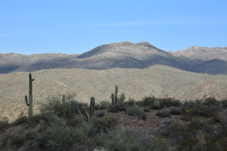
Bradshaw Mountains seen from High Desert Trail

Tethered to both a kiddie playground a backcountry historic trail, High Desert Park in Black Canyon City doubles up as an approachable community gathering space and gateway to the rugged canyonlands of Central Arizona.
Blooming barrel cactus on High Desert Trail

Dubbed a “Desert Gem” by the High Desert Helpers, Inc., the 501(3)(c) non-profit that manages the park and the High Desert Trail within it, the Yavapai County site packs a massive amount of fun into its 89.1-acre parcel.
Kings Canyon Overlook on the "blue" loop

The park is situated west of Interstate 17 among the suburbs of Black Canyon City, Rock Springs and the foothills of the Bradshaw and New River Mountains.

Swing sets, restrooms, water, picnic tables, grills, sports facilities and community center anchor the family-friendly plot while a total of 2.7 miles of outdoor trails offer non-intimidating ways to get some exercise.

A rabbit hops through a cholla forest

The High Desert Trail has two parts. The main “blue” trail is a 1.7-mile loop and the 0.3-mile “yellow” trail (also known as Joedy’s Trail) that may be used for a shorter loop option.

"Tablelands" stand out on the High Desert Trail

The hike begins at a shade pavilion with maps and interpretive signs describing local wildlife. Heading west for a counterclockwise hike is the preferred plan as it takes on the climbing section of the trail early on. Initially the trail moves through a cholla forest that’s part of the park’s 0.8-mile original nature trail that has been lassoed into the blue perimeter loop.

Junction of the "blue" and "yellow" trails

Hike begins in High Desert Park in Black Canyon City

 Rustic wood signs placed along the route identify native plants such as jojoba, barrel cactus and saguaros.  Right from the get go and throughout the hike, gorgeous mountain views and a tableland of flat topped mesas peek through cholla forests and thickets of diverse desert vegetation.
Desert senna blooms April - October

Quartz and basalt: part of the area's complex geology

Rusty artifacts on the "yellow" trail

The trail’s appeal is augmented with benches placed at scenic spots and two spectacular overlook points. A short spur trail leads to Kings Canyon Overlook, a stony edge on the far west end of the blue loop trail that hangs over the deep gorge of Black Canyon.
Monsoon rains coax the green out of ocotillo

At the south end of the perimeter loop, the Rock Springs Overlook peers over the severe cuts of the Agua Fria River channel, and the famous Rock Springs Café, pies and all. 
Rock Springs scenic overlook

The "yellow" trail cuts through the main "blue" loop

Never quite escaping the subdued rattle and hum of Interstate 17, the loop’s east leg dips downhill to meet a connector path that leads to a popular trailhead for the  Black Canyon National Recreation Trail—a long-distance, non-motorized historic route that goes from Phoenix to the Verde Valley. The final leg swings north through classic high desert eco zones and saguaro-lined ridges replete with a sampling of the quartz outcroppings, metamorphic stone slabs and volcanic ejecta that contribute to the area’s complex geological footprint, completing a fun and informative trek lodged between freeway and wilds.
Spectacular mountain views dominate the hike

LENGTH: 2.1 miles (blue and yellow trails)

RATING: moderate

ELEVATION:  2,024 – 2,153 feet   

GETTING THERE:

19001 Jacie Lane, Black Canyon City.

From Interstate 17, take the Black Canyon City/Rock Springs exit 242. Turn left at the stop sign, then right at the Old Black Canyon Highway junction. Continue a short distance  to Jacie Lane, turn left and follow the road into the park.

PARK HOURS: Dawn to dusk daily

FACILITIES: restrooms, water, picnic tables & grills, sports facilities, kiddie playground

INFO:

Yavapai County Parks

yavapaiaz.gov/facilities/yavapai-county-parks/high-desert-park

High Desert Helpers, Inc.

highdeserthelpers.org/park/


Monday, April 1, 2019

MOUNT UNION

Mount Union: Prescott National Forest
 View of Mt. Davis seen from 7979-foot Mt. Union
Where as the thrill of reaching a mountain summit usually comes with a wham-pow jolt of pride, gaining the high point of the Bradshaw Mountains in Yavapai County kind of creeps up on you instead. 
Snow on the Dandrea Trail No. 285, 3-30-2019.
The hiking trails that lead to the 7979-foot pinnacle of Mount Union are neither technical nor precipitous.
The fire lookout on Mt. Union was built in 1933
Unlike other Arizona peaks, there are no false summits, no cliff-dangling passages and no obvious risks to life and limb. Regardless of its lack of adrenaline rushes, the straightforward route is not without its challenges.
Big views on the Yankee Doodle Trail No. 284
It’s only a two-mile hike to the top, but working through the rough, rocky course is an exercise in balance and tenacity. It’s a real ankle-twister, so sturdy footwear and hiking poles are essential. Located southeast of Prescott near the mountain community of Potato Patch, the Dandrea Trail No. 285 and the Yankee Doodle Trail No. 284 combine for a short but tricky route to the peak. The trails are signed only by their numbers, not their colorful monikers which, along with nearby landform names, were assigned by miners working for competing factions during the Civil War.  

The bare bones trailhead straddles a drainage where the headwaters of the Hassayampa River—spilling from the spring-laden slopes between Mount Davis (named for President of the Confederate States, Jefferson Davis) and Mount Union-- begin to gain momentum.  Hop the chugging stream and head toward the “285” sign, which marks the first leg of the circuit. Trail No. 285 is an old mining road that was built long before the concept of sustainability gained traction and thus has not held up well. Thrashed by the forces of nature, the road has devolved into a quagmire of loose rock and debris. Sometimes paralleling the Hassayampa drainage, sometimes swamped by its overflow, trail conditions vacillate between poor and treacherous. But, picking your way though is part of the adventure. Also, several unmarked spur paths that spin off the main road can be confusing. To stay on track, always head right at these junctions. 
The summit road was snow-covered on 3-30-2019.
 
View from a high section of the Dandrea Trail
Between keeping an eye to the ground to avoid falls, be sure to take time to appreciate the thick coniferous forest that surrounds the trail. The canyon-bound lower mile of the route is wrapped in thick, moss-draped woodlands dominated by Douglas and white firs plus spotty stands of aspens struggling to find the sunlight they need to survive. 
A typical scene on the rocky Dandrea Trail
As the trail gains elevation, airy stands of Alligator junipers and Gamble oaks take over, opening up views of distant Granite Mountain.
Big Bug Mesa (mid field right) seen from Trail No. 284
At the 1.2-mile point, the route emerges from the forested canyon at a gate and 4-way junction on the saddle between Mount Davis and Mount Union. Here, Trail 285 continues 1.6 miles downhill to the abandoned Dandrea Ranch site--a pretty side trip if you’re so inclined. But if your eyes are on the summit prize, head right (southwest) and follow the Yankee Doodle Trail No. 284.  Although still rocky, this 0.6-mile leg is much less hazardous and more exposed than the canyon segment.  Climbing through an oak-fringed corridor, Trail 284 features peeks of the fire lookout and communication towers on the summit and grand mountain vistas.  To the east, the long form of Big Bug Mesa stands out among minor ridgelines and pine-covered foothills. Where the trail meets the dirt summit road, head left (remember this spot because it’s easy to miss on the way back) and make the final 0.2-mile slog to the top.   
Trail 285 climbs through the headwaters of the Hassayampa
A fire lookout that was built by Civilian Conservation Corps workers in 1933 stands 30 feet above the bald, boulder-cluttered apex.
The saddle junction
At its base, the names of CCC workers etched into a cement slab add a note history and humanity to the creaky metal structure and its companion cabin.  The tower is still in active service and is occupied during fire season.  
View from the summit of Mount Union
A walk around the tiny peak reveals 360-degree vistas that validate this mountain as the standard-bearer of the Bradshaws while demonstrating that a summit trek doesn’t have to be the hardest, highest or most inaccessible to deliver a rewarding experience.
Douglas fir trees dominate the canyon segment of the hike
Mount Union is high point of the Bradshaw Mountains
Trailhead at the edge of the Potato Patch community.
LENGTH: 4 miles roundtrip
RATING: difficult
ELEVATION: 6849 – 7979 feet
GETTING THERE:
From State Route 69 in Prescott, turn south on Walker Road (intersection with the stoplight near the Costco center) and continue 10.5 miles to the “T” intersection at Poacher’s Row that’s marked by sign for the Potato Patch community. Turn left and continue 0.7 miles to where the road ends at the 285 trailhead. There’s parking for about two vehicles at the trailhead and there are additional spaces along the road, but be respectful of the private property in the area and do not block driveways. 
Summit marker.
High-clearance vehicles are recommended as the last few miles of the access roads are on rough dirt with potholes. There are no fees or facilities at the trailhead.
INFO: Prescott National Forest

Tuesday, January 2, 2018

BLACK CANYON TRAIL: BUMBLE BEE SEGMENT

BLACK CANYON TRAIL: BUMBLE BEE SEGMENT
Old gate with Sunset Point on canyon edge--far right.
Look down from the viewing deck at Sunset Point rest area on Interstate 17 south of Cordes Junction and the rugged terrain of what the Black Canyon Trail Coalition calls “Arizona’s Outback” rolls out 600 feet below.  The land down under the lookout is appropriately named Sheep Gulch. Whether this is happenstance or a nod to the Australian sheep stations (Aussie speak for ranches) that this gorge resembles, it’s an awe-inspiring sight to behold. Although it’s tough to see from the rest area, the middle section of the 80-mile Black Canyon Trail cuts through this beautiful abyss that’s cradled in a geological upheaval of pre-Cambrian granites, and scaly schists with sprinklings of orange-tinged quartz tossed about like confetti.
Saguaros frame Bradshaw Mountains vistas.
 The non-motorized-use route that stretches from the Carefree Highway in Phoenix to near the town of Mayer off State Route 69, has been designated a National Recreational Trail for its historic significance.
Hikers traverse a section burned by 2017 wildfires.
The trail has been in use since pre-historic times serving as a Native American pathway, a track for herding sheep and other livestock and a travel corridor for traders.  Surrounded by the rough-cut, mineral-rich peaks of the Bradshaw Mountains and the stream-chiseled gullies of Black Canyon, this moderately difficult, easy-to-follow section of trail clings to the canyon walls as it moves northward in smooth swoops and hairpin turns. 
Mountain views are the highlight of the hike.
Beginning at the Gloriana Mine trailhead, the hike heads 4.6 miles north to where it meets the American Gulch Segment near the town of Bumble Bee—a former Phoenix-to-Prescott stage stop established in the mid nineteenth century.
Ocotillo near the Gloriana Mine trailhead. 
 Although this area was impacted by the July 2017 lightning-caused Brooklyn, Bull, and Cedar fires, the scenic value of the hike was only marginally diminished. The trail is clear and the epic mountain vistas for which this segment is famous are still as crisp and inspiring as ever.  The trail mostly follows the 2800-foot elevation contour before it dips into the gulch below Sunset Point. Here, the faint rumble and whir of the freeway above caps a contrasting pastoral scene of ranches, cacti-studded grasslands, creekside willows and the comings and goings of ATVs, hikers and the seasonal parades of sheep that still graze around the sleepy ghost town and its defunct gold mine prospects.
The land down under Sunset Point.
LENGTH: 4.6 miles one-way
RATING: moderate
ELEVATION: 2520' - 2840'
A hairpin turn through a gully.
GETTING THERE:
Gloriana Mine Trailhead: From Interstate 17, take the Bumble Bee/Crown King exit 248 and go 1.2-miles west on Bumble Bee Road (FR 59) to the trailhead on the left. Segment begins across the road from the parking area.  Roads are 100% paved.
 INFO & MAPS: Black Canyon Trail Coalition

Monday, December 12, 2016

BLACK CANYON TRAIL: Gloriana Segment

BLACK CANYON TRAIL: Gloriana Segment
Near Bumble Bee
View of Bradshaw Mountains from BCT
Sandwiched between the spot where Interstate 17 splits to begin its climb up to the mesas and gorges of Agua Fria National Monument and a gaping valley below the Bradshaw Mountains, the Gloriana Segment of the Black Canyon Trail is the middle road between a freeway and  dusty dirt double tracks. The 80-mile route flows from Carefree Highway in Phoenix to just outside of Prescott following centuries-old Native American trails, defunct livestock paths, dirt roads and sections of new construction.
A battered saguaro stands above Maggie Mine Road
The trail is divided into segments with trailheads located along its entire length. The 3.4-mile-long Gloriana Segment is smack dab in the middle and wanders along slopes above the scoured courses of Sycamore, Poison, Arrastre and Rock Creeks.  Geology buffs will find a plenty to explore. Within a few hundred feet of the trailhead, the path bumps into an outcropping of metamorphic rock tilted vertical and resembling fossilized Stegosaurus fins weathering from the earth. A couple of hairpin turns through a gully of giant saguaros and a short walk through a Palo Verde forest deposits hikers on a breezy edge splattered with chunks of milky white quartz overlooking Maggie Mine Road.
"Stegosaurus" rock slabs
Take a moment to spy the various mine prospects that dot the hillsides. Continuing south, the trail wanders through sunny rangeland
accompanied by morphing mountain vistas in what the Black Canyon Trail Coalition calls “Arizona’s Outback”.  The segment can be tackled as an out-and-back day hike, multi-day backpack or a one-way car shuttle using maps available on the coalition’s website.
Juvenile saguaros on the Gloriana Segment of BCT
LENGTH: 6.8 miles out-and-back
RATING: moderate
ELEVATION: 2520’ – 2720’
GETTING THERE: Gloriana Trailhead.
From Phoenix, go north on Interstate 17 to the Bumble Bee/ Crown King exit 248. Follow Bumble Bee Road 1.1 miles to the trailhead on the left. There are no facilities. The hike begins at the south side of the lot near the big sign. Roads are 100% paved. (The sign across the road marks the start of the Bumble Bee Segment.)


Tuesday, December 1, 2015

BLACK CANYON NATIONAL RECREATION TRAIL

BLACK CANYON NATIONAL RECREATION TRAIL
Big Bug Segment
Bradshaw Mountain views on the Big Bug Segment of BCT

You'd be hard pressed to find another Arizona route imbued with as much history as the Black Canyon Trail. Records of its many centuries of use are preserved in rock art, public documents and the dens of wily desert critters. Since its origins as a Native American footpath, it has morphed into a cattle driveway and wagon road before settling into its current role as a recreational trail for hikers, bikers, equestrians and (in a few places) ATVs. Running for roughly 78 miles in a twisting, north-south thread between the Carefree Highway north of Phoenix to the town of Mayer outside of Prescott, the route traces the foothills and valleys of the Bradshaw Mountains. The trail is organized into convenient segments---each with its own set of defining characteristics. Depending on where you are on the trail, you'll see smatterings of the ruins, petroglyphs, ranches, mining operations and windmills that document the trail's diverse heritage. Augmenting the artifacts is a continually changing mix of ecosystems ranging from canyon-bound, moist riparian strips to dry scrubby savannah.
The northernmost Big Bug Segment falls squarely on the "scrubby" end of the scale. It's a wind-in-your-face kind of hike though exposed rangelands with mountain views all around. The first mile runs through a bucolic territory of homesteads and horses along Highway 69. After rounding a bend, the route ducks into a quiet habitat where every thump of a hiking boot has the potential to rouse rabbits and scrub jays from their juniper tree sanctuaries. Just beyond the 2.5-mile point, the trail crosses Antelope Creek Road then follows a Jeep track 0.6-mile to connect with the Drinking Snake segment. Along the way, keep an eye out for packrat middens. They look like scrap piles but further inspection reveals tiny entrances covered with everything from roots and twigs to cow dung and bones that are occasionally topped off with stray parts (belt buckles, lens caps, socks) left behind by (or pilfered from) travelers. These rodent abodes are built upon over many generations and some are tens of thousands of years old. The tiny time capsules can contain treasure troves of mummified and fossil plant, animal and human relics. What is garbage to the untrained eye is gold to the scientists who study the middens to understand biotic and climate change over time. So, through their unsavory housekeeping habits, the rat's have become "accidental archivists" and important contributors to the history of a classic Western trail.
LENGTH: 6.2 miles out-an-back (as described here)
RATING: easy
ELEVATION: 3,950' - 4,140'
FACILITIES: vault toilet
GETTING THERE:
Big Bug Trailhead:
From Interstate 17 in Cordes Junction take exit 262 for State Route 69 heading north toward Prescott.
Set your odometer and drive 4.2 miles to a point 0.7-mile past mile marker 266, (N 34 21.823 W 112 10.556) turn left onto an unmarked drive and continue 0.1 mile to the trailhead. To find the trail, pass the gate near the restroom and stay to the right of the fences and corral. (There was a large carin here on our visit). Follow the trail though a drainage, and veer right at the top of a rise where the trail splits. Follow the trail to the right of a fence line and you'll soon see a BCT sign. From here, the trail is easy to follow.
INFO & MAPS:
Black Canyon Trail Coalition
MORE PHOTOS:

Sunday, August 16, 2009

YEAGER CANYON LOOP

YEAGER CANYON LOOP Prescott National Forest This scenic route melds three unique trails into one wide loop along the southern slopes of Mingus Mountain. In order to get the tough climbing out of the way, it’s best to hike clockwise. From the trailhead, head down into the pinion-and-juniper-dotted drainage and hang a left to pick up Yeager Canyon Trail #28 which parallels Highway 89 for a short stretch before angling east where it takes on the exposed ridgelines above Prescott Valley. At the two-mile-point, veer right at a three-way intersection, continue a few yards on an old dirt road and look for the (easy-to-miss) sign for Yeager Cabin Trail # 111 on the right. Here, the trail drops into a side canyon, cutting through a dense forest of Ponderosa pines and oaks with many sun-soaked clearings. After summer storms, water can be found in the low-lying ravines. Trail #111 continues for 1.9 miles to Allen Springs road. Here, turn right onto the road and hike about a quarter-mile to Little Yeager Canyon Trail #533 on the right. This final segment showcases a vibrant splattering of blooming shrubs and wildflowers against a backdrop of wide-angle vistas of Prescott Valley. HIGHLIGHTS: expansive views of Prescott Valley LENGTH: 6-mile loop RATING: moderate ELEVATION RANGE: 6,000 – 7,200 feet DRIVING DISTANCE FROM PHOENIX: 125 miles GETTING THERE: From Prescott, go east on Highway 89A for 10 miles to an unmarked dirt turnout on the right side of the road. The parking area is near a road sign that states: “Flagstaff 69, Jerome 10.” INFORMATION: Verde Ranger District, Prescott National Forest, 928-443-8001
http://www.fs.fed.us/r3/prescott/recreation/trails/verde/yeagercan28.shtml