Find A Trail. Start Your Search Here:

Showing posts with label Anderson Mesa. Show all posts

Monday, June 15, 2026

Plateau Potato Lake

PLATEAU POTATO LAKE

Potato Lake Tank on Anderson Mesa

Roughly thirty minutes south of the summer hiking magnet of Flagstaff, is a quieter but no less attractive trekking destination.

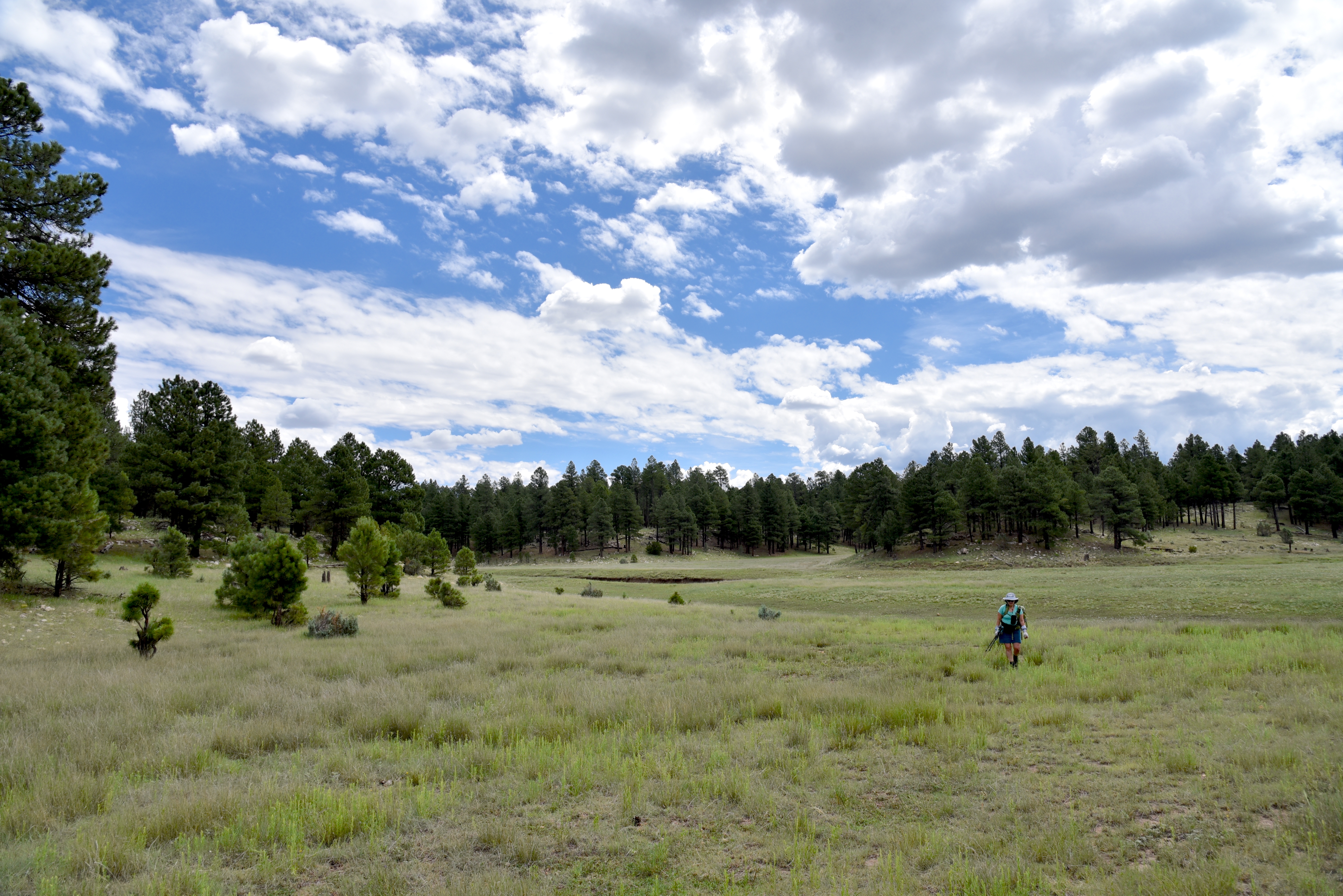
The basin of Potato Lake on Anderson Mesa

The Plateau Lakes on Anderson Mesa offer respite from crowds in an under appreciated landscape replete with quirky geological features.
Forest Road 82D near Als Lake

The Plateau Lakes Region in Coconino National Forest is anchored by Mormon Lake—Arizona’s largest natural lake.

Texas Frog Fruit blooms April - November

During years with lots of precipitation, the lake can span an area up to 12 square miles. 
View of Peaks from FR9484D

But that’s the exception, not the norm.  Mostly, it’s a scenic yet mucky wetland of puddles and swales that still manages to attract wildlife and support a fringe of water-loving vegetation.
Forest Road 82D near Als Lake

It’s also the mother ship per se for dozens of smaller natural water pockets, wildlife waterholes and created lakes that orbit its massive basin.

Geologists describe the Plateau Lakes as naturally occurring bowl-like depressions formed by various tectonic events that resulted in slumps and sinkhole features in the volcanic landscape.

Field Bindweed blooms May - September

Junction FR82D and FR9484D

Spread across the flatland like pock-marks or lunar craters, some are no larger than a kiddy pool while others rival football stadium proportions. Like Mormon Lake these hollows vacillate between weedy swamps and shallow pools that evaporate entirely in times of drought leaving behind crop-circle-like impressions. 
Entrance to Potato Lake

Hiking to the Plateau Lakes can be done by hopping on the Arizona National Scenic Trail Passages 29 and 30 which skirt by several, or by using a network of rough dirt roads that traverse the mesa. 

Typical scene on FR9494D

One interesting destination is Potato Lake.  Don’t be confused, though. This is a different animal from the watery, crawdad infested “solution depression” (geology speak for a kind of sinkhole) Potato Lake off Forest Road 300 (Rim Road) on the Mogollon Rim near the community of Pine. (Read the POTATO LAKE story on this blog).

The easy hike to "Plateau Potato Lake” uses three easy-to-navigate dirt roads. Beginning on Forest Road 9117F, the trek heads east for 0.4-mile to where it meets the fenced edge of Post Lake—another Plateau Lake. 

Potato Lake Tank

A storm brews over Als Lake

The rocky two track then bends north onto the mesa and merges into (unsigned) Forest Road 82D. 

Anderson Mesa is a mostly flat, windswept expanse dotted with junipers and intermittent plots of Ponderosa pines.

San Francisco Peaks seen from FR82D

The airy expanse is criss-crossed with draws and canyons that disrupt exposed grasslands favored by pronghorn.  The mesa is surrounded by volcanic mountains that churn up weather, which means it’s almost always windy here. 
Post Lake

At the 1.3-mile point, views of  8,463-foot Mormon Mountain to the west and 12,633-foot San Francisco Mountain north of Flagstaff stand out over Als Lake, another Plateau Lake with hit-or-miss water levels. It’s worth mentioning that even when bone dry, the footprint of these ephemeral lakes are often lush with wildflowers and knee-high grasses.
Storm over Potato Lake Road

Past the lake, the road meanders through fragrant woodlands dominated by junipers until it comes to a fork where FR9484D spins off to the right. The road, which is also known as Potato Lake Road is signed, but the numbers are barely legible. At this juncture, FR82D continues a half-mile north to one of the most well-known Plateau lakes—Deep Lake.

It’s worth a side trip on the way back. (Check out the DEEP LAKE story on this blog).  FR9484D continues through more juniper-shaded terrain with chunks of basalt strewn about the rusty soils.  The route meets a junction with FR9119W at 2.8 miles. FR9119W heads left and circles Potato Lake, but this trek continues straight ahead on FR9484D.  After another 0.2-mile, a stand of thick greenery of pines, firs and oaks herald the entry to Potato Lake.

Passing through an aboreal archway, the road opens up to views of the sprawling lake. In early June 2026, the lake was dry, but adjacent Potato Lake Tank contained a basin of residual muddy water.  Built into the south edge of the lake with an earthen dam, the margins of tiny waterhole showed signs of wildlife activity.  Elk, deer, waterfowl, raccoon and coyote tracks sunk deep into the moist muck signal it’s time to turn the hike around and leave the precious water to the winged and furry forest residents. 
trailhead


LENGTH: 6 miles roundtrip

RATING: easy

ELEVATION: 7,049 - 7,127 feet (447 feet of accumulated elevation change) 

GETTING THERE:

From Flagstaff go 17 miles south on Lake Mary Road (County Road 3) to Forest Road 82E on the left just past milepost 327 which is signed for Ashurst Lake. Follow FR 82E 1.7 miles to FR 9117F on the left. A faded sign marks the road.  There’s parking in dirt pullouts. 

Forest Road 82E is washboard gravel suitable for all vehicles. High clearance is recommended on FR 9117F.  No facilities or fees. 


Monday, August 5, 2024

Willow Valley Dam

WILLOW VALLEY DAM

Sign on FR9352Q

Willow Valley on the Mogollon Rim is best known for its narrow, cliff-bound course. Rugged back country trails including Maxwell, Tramway, Calloway and the milder Willow Crossing lead into its chiseled sandstone depths in West Clear Creek Wilderness. At its lower reaches, Willow Valley merges with Clover Creek where both empty into West Clear Creek.

Bar D Corral on FR 93

Experienced, well-equipped hikers must brave rough roads, sketchy vertical descents, wading and scrambling to explore the wilderness end of the Coconino National Forest valley located roughly 40 miles south of Flagstaff.
Flat Draw Tank near Bar D Corral


But the valley’s upper reaches in the Plateau Lakes region southeast of Mormon Lake are a whole other story.  On the windy expanse, the valley is a shallow, yawning break in the landscape, hemmed in by fringes of Ponderosa pines. 

Calliopsis bloom June - September

It’s a beautiful, more accessible side of the valley. Replete with water holes, corrals and a maze of dirt roads, the bucolic slice of forest stands in stark contrast to its deeper, wilder end.
Scene along FR 93

A few miles south of the community of Happy Jack, off Lake Mary Road, Forest Road 93 serves as a route to Willow Valley Dam and a quiet pocket of forest that’s easy for just about anybody to explore on foot.

The hike follows Forest Road 93, a level dirt track with lots to see along the way. 

Wild geranium bloom May - September

At the 0.75-mile point, the road meets Bar D Corral, a collection of barbed wire, fencing and other cattle roundup structures.  Nearby, the glassy pools of Flat Draw Tank reflect trees and sky while providing water for wildlife and domestic cattle. 
Willow Valley scene on FR234C

Another mile, and the road comes to Wingfield Corral with its tangle of fencing and complex construct of metal and wood.  At the  north end of the corral, a secondary dirt road heads east. 
The breached Willow Valley Dam

It’s not signed, but this is Forest Road 234C, a 0.2-mile route that crosses over Willow Valley south of the dam. It’s a fun detour, but to get to the dam, skip FR234C and continue 0.2-mile past the corral and head right on Forest Road 9352Q which is open only to foot travel. 
Puddle in the break of Willow Valley Dam

The 0.3-mile dirt road ends at a grassy swale.  Open to the sky, the wide depression is also known as Willow Valley Lake. 
While rain-scoured channels and ample greenery hint that water occasionally runs through, the Willow Valley Dam that had contained the “lake” has partially collapsed. 
Willow Valley Dam seen from FR 9352Q

The earthen embankment is still impressive, though. Its shrub-encrusted walls stand high above the valley with ephemeral puddles at its base. 
Willow Valley "Lake" is a moist swale

Wildflowers thrive in the moist soil and robust elk tracks suggest that the site is still an important wildlife resource.  
Wingfield Corral on FR 93

Forest Road 9352Q continues up a knoll to a shady overlook above the dam that frames picture perfect views of a snippet of Willow Valley’s origin story.

LENGTH:  6 miles roundtrip (out-and-back to the dam beginning near Lake Mary Road)

RATING: easy

ELEVATION:  6,924 – 6,745 feet

GETTING THERE:

From Flagstaff, go 42 miles south on Lake Mary Road (County Road 3) to Forest Road 93 on the left past milepost 302 signed for Willow Valley Dam.  Park along any of the dirt turnouts or dispersed camping sites along the road.  FR93 is maintained dirt suitable for all vehicles for about a mile. After that, high clearance is recommended.

Monday, July 18, 2022

Arizona Trail: Passage 31

ARIZONA NATIONAL SCENIC TRAIL: WALNUT CANYON PASSAGE 31

Gate on Passage 31 of the Arizona Trail

Shady and cool, Passage 31 of the Arizona National Scenic Trail is a satisfying respite from summer heat.  The 17.9-mile segment of the 800+-mile, state traversing route

drops off the plateau lakes region of Anderson Mesa and heads into pine-oak woodlands in Coconino National Forest southeast of Flagstaff.  Also known as the Walnut Canyon passage for its swing by the finger canyons and periphery of Walnut Canyon National Monument, this close-to-town segment of trail has several access points that make it perfect for day hikes, loop and car shuttle options. One trip to try goes from Marshall Lake to Sandy’s Canyon.

Greenery around Marshall Lake Tank

At the Marshall Lake trailhead, hikers get a reality check on the effects of drought.  While Marshall Lake is rarely more than a shallow, reed-choaked pond, this year, it’s bone dry.  Still, its elongated, pine-wrapped footprint is a picturesque sight and favorite grazing territory for elk.

Mountain vistas are meager, trees are major

The hike heads north from the large Arizona Trail sign along a well-defined and maintained singletrack.

Sign at Marshall Lake trailhead

 
Thick tree coverage and riffled terrain obscure big vistas, so this hike is more about immersing in the details of forest life. 
There are many ways to extend this Flagstaff hike

It’s a great place to smell “yellow belly” pines--older Ponderosa pine trees that have developed yellow-brown bark scales and emit a syrupy fragrance that’s often described as butterscotch, vanilla or cardamon. 
Marshall Lake was dry, July 2022

Each tree has a unique olfactory signature that blooms when warmed by the sun. 
Winged buckwheat blooms July - September

Go ahead and take a whiff, but be respectful. There’s no need to damage the bark to determine if the sap is sweet, savory or spicy.  
Hike may be extended into Sandy's Canyon


About 1.5 miles in, the green swale behind Marshall Mesa Tank appears below a set of easy switchbacks that lead into a shallow ravine.  The wildlife water hole is contained by an earthen dam, but, like the lake, it was dry, but lingering moisture feeds a fringe of wildflowers and elderberry trees.

Limestone formations in Sandy's Canyon

Several more minor downhill twists lead to the junction with the Sandy’s Canyon trail. 

Yellow belly pines add olfactory notes to the hike

Here, the Arizona Trail veers right into the canyon where bizarre limestone formations are the key attractions on this very popular forest destination. For those who parked a shuttle vehicle at the Sandy’s Canyon trailhead, veer left at the junction and hike 1.5 miles for a 5.6 mile one-way trek.
Horned lizards are easy to spot on the ArizonaTrail

For a longer hike, Passage 31 continues north to Interstate 40 where it connects with the Elden Mountain Passage on the east side of Flagstaff. The trail also links up with the Flagstaff Urban Trails System and the Flagstaff Loop trail. Consult the Flagstaff city website for details on how to customize a hike circuit. Otherwise, just shit into reverse at the junction for an 8.2-mile out-and-back day hike.

LENGTH:

• 8.2 miles round trip, Marshall Lake trailhead to Sandy's Canyon junction and back.

• 17.9  miles one way for the entire segment.

• 5.6 miles one way for car shuttle.

RATING: moderate

ELEVATION: 6,885 – 7,185 feet as described here (6,500 – 7,185 feet for full passage)

GETTING THERE:

Marshall Lake trailhead:

From Flagstaff go 9 miles south on Lake Mary Road (County Road 3) to Forest Road 128 on the left, signed for Marshall Lake. Continue 2.2 miles on FR 128 (pass the observatory) to the Arizona Trail post at FR 128D, turn left and continue to the parking turnout at the large Arizona Trail sign.

Sandy’s Canyon trailhead:

From Flagstaff,  go 4.5 miles south on Lake Mary Road to the Sandys Canyon Trailhead on the left. Follow Sandy’s Canyon trail 1.5 miles to the Arizona Trail junction on the right.

INFO & MAPS:

Arizona Trail Association

Aztrail.org

Flagstaff Urban Trails System

https://www.flagstaff.az.gov/1379/Flagstaff-Urban-Trails-System-FUTS


Monday, May 10, 2021

Mormon Lake Lookout Site

MORMON LAKE LOOKOUT SITE

Gate on Mormon Lake Lookout road

There are few certainties in life, but one fixed reality is, things fall apart.  Whether a star dying in a spectacular super nova or the protracted disintegration of a favorite pair of shoes, sooner or later everything in the taxonomy of the natural world will expire.  While we are dialed-in to the mundane disintegrations that go on right under our noses every day (oil in a car, paint on house, cells in our brains) the slow-burn of obsolescence and decay on mountain back roads reads more poetic than prosaic.  
Cinder pit along FR 124C

Perhaps because we don’t look at them every day, the breakdown of land forms and back woods human-made artifacts barely registers.  And since we’re not scrambling to fix them, they exist as curiosities instead of problems.
Masonry box at Iowa Camp Spring

A stroll along Forest Road 124C near Mormon Lake exposes several sites where falling apart happens with engaging style.

Pine thermopsis bloom April - July

 
Located at the south end of the Arizona’s largest natural lake, FR124C in Coconino National Forest is a rough two-track open to motorized travel that traces the edge of Anderson Mesa in the plateau lakes region 25 miles south of Flagstaff. 
View from the abandoned lookout site

The road makes a moderate, steady climb heading toward an unnamed hill where the Mormon Lake fire lookout tower once stood.  From the start, the route enters a forest dominated by ponderosa pines and gamble oaks, steering away from the whir of cars passing on Lake Mary Road.  At the 0.3-mile point, a narrow side road on the left leads to a cinder pit that looks like a miniature version of Red Mountain, a collapsed cinder cone volcano north of Flagstaff.  The pit, which is sometimes used by recreational shooters, is a long, broken cliff of volcanic rock with ashen hoodoos eroding out of a cascade of crumbling red cinders.  Volcanic features like this one can form over weeks to years but take millions of years to break down as is happening here.
Summit views are sparse but breathtaking

Beyond the pit, the road enters a higher eco-zone where Douglas, white and cork bark fir trees mingle with the pines.  Between the branches, glimpses of Mormon Lake going through one of its cyclical breakdowns appears as a golden pasture where during wetter years, a shallow lake fills the bowl-like depression.  As the forest grows thicker and the road becomes steeper, a pop of wildflower color gives away the location of the moist environment around Iowa Camp Spring.  Take the non-motorized Forest Road 9474D detour and hike a few yards to visit the site and its stone-masonry spring box.  Trees, shrubs and time are encroaching the historic artifact that looks as if it’s been a while since water flowed in more than a trickle from its rusted pipes.  Around the point where the road reaches 7,600 feet in elevation, a small grove of aspen trees stands in a drainage on the right. 

FR124B leads to the lookout site

Fremont barberry blooms April - July

Aspens have been in a decades-long decline in Northern Arizona.  Stressed by insects, pathogens, drought, frost, browsing elk and dense forests that block sunlight, the trees that reproduce mostly by sprouting root systems that can be viable for up to thousands of years are not regenerating at a healthy rate.  Forest scientists are trying to figure out what is causing the dieback and how best to manage the situation. 
Rubble marks the location of the old fire lookout

Mixed conifir woodlands along FR 124C

At the 2.2-mile point, the road comes to a fork where Forest Road 124B, a non-motorized dirt road, swerves off to the right.  This junction is signed, but the road number post is not easy to spot.

Aspens are in decline in Coconino NF

 
FR124B leads to the abandoned lookout site, gaining 277 feet in just under a mile.  Near the top of the hill, there’s a metal gate and a trail log marking the final 0.2-mile walk to the summit.  On top, the views that can be found in the spaces between trees are sparse but breathtaking. 
Mormon Mountain (right) seen from the trailhead

A jumble of boulders hint at the recent decommissioning and demolition of the former Mormon Lake Lookout and cabin.  The site was home to a wooden lookout built in 1915 that was replaced in 1927 with a 48-foot metal tower topped with a 7 x 7-foot cab.
Dry Mormon Lake (center) sen from FR 124C

 
It’s unclear why the fire watch tower was abandoned, but the Hutch Mountain Lookout to the south seems a likely usurper. 
Eroding hoodoos at the cinder pit site

Judging from backhoe marks on boulders strewn on the site, the tower’s demise was planned, swift and clean, unlike the other falling apart things along the roads leading to it.

LENGTH:  5.9 miles round trip

RATING: moderate

ELEVATION:  7,109- 7,977 feet

GETTING THERE:

From Flagstaff, go 25.6 miles south on Lake Mary Road (County Road 3) to Forest Road 124C on the left past milepost 319.  Park in the dirt turnouts. 

INFO:

http://nhlr.org/lookouts/us/az/mormon-lake-lookout/