Find A Trail. Start Your Search Here:

Wednesday, July 17, 2013

Embracing the details of an ordinary trail


SANDY SEEP TRAIL
Flagstaff
Fire scars visible on the ridge

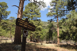
This easy trail at the base of Elden Mountain rarely makes it onto the typical hiker's bucket list.  Widely regarded as a "connector" route for some of Flagstaff's more iconic trails (Fat Mans Loop, Little Elden, Arizona Trail) trekkers plow through this repurposed Jeep road like rockets on their way to the moon.  Although power hiking is valid use of public lands, there's also much to be gained by embarking on pensive sightseeing walks. This style of hiking embraces the details of otherwise "throw away" trails making them journeys to savor rather than tedious means to an end.  And, there's a lot to see on Sandy Seep trail.  Here's a sample of how to savor the details:
Hug a Yellow belly. Ponderosa pines that are at least 150 years old develop scaly yellowish bark with aromas similar to butterscotch, vanilla, cherry-almond and other sweet confections---take whiff!
Brush up on your geology. Bring a guidebook and learn to identify volcanic rocks like pumice, basalt, and obsidian.
Stop and smell the cliff-rose. The dominant flowering shrub on the trail blooms from April through September.
Survey Fire scars: Witness how the landscape is recovering from both the 1977 Radio Fire and 2010 Schultz Fire. The scars are visible on the high slopes to the west of the trail.
Sing with Stellars jays. These vociferous, electric blue birds sport pronounced feathered head crests and are easy to spot rustling about in the pines.
See the "seep". Located about 0.5 mile past the Little Elden/Christmas Tree junction (go right) a 
water-hogging depression feeds a tiny green cienega.
Hound for horned lizards. They're talented at hiding in plain sight, so be wary of stepping on one. Look for them near their food source--anthills.

Horned lizard

LENGTH: 6 miles roundtrip
RATING: easy
ELEVATION: 6900' - 7300'
GETTING THERE:
Sandy Seep trailhead:
From Phoenix, travel north on I17 to the I40 interchange in Flagstaff.  Head east on I40 to exit 201 for US89 north.  Drive north on US89 to milepost 421 (0.5 mile north of  Townsend-Winona Road) and turn left onto FR 9139 and drive 0.1 mile to the trailhead.
INFO:
Yellow belly Ponderosa pine
Flagstaff Ranger District, Coconino National Forest, 928-526-0866
MORE PHOTOS:

Monday, July 15, 2013

A hike through deer territory


CHRISTMAS TREE TRAIL
Flagstaff
Mule deer on the trail

For the dancing herds of mule deer roaming the grasslands on the eastern slopes of Flagstaff's Mount Elden, cliff-rose is considered a browsing delicacy. When in bloom (April-September), the delicate white roses spill a tart-sweet perfume into the mountain breezes which churn the scent through pines boughs to form an airborne elixr---"eau de cerf".  This is indeed deer paradise---ample food, wide open spaces and woodlands replete with hiding places for foals.   Wildlife-loving hikers will almost certainly share the Christmas Tree trail with the elegant beasts who will usually pause to indulge their curiosity about approaching humans before galloping off into the brush. 
Although this easy footpath  is mostly used as a connector route for the dozens of more challenging trails around Mt. Elden, it makes for an excellent solo destination when hiking with kids (and I saw quite a few hitting the dirt this week) or as a deer-spotting expedition.

LENGTH:
From south: 4 miles roundtrip
From north: 6 miles roundtrip
RATING: easy
ELEVATION: 6900'- 7250'
GETTING THERE:
South access, Elden Mountain trailhead:
From Phoenix, travel north on I17 to the I40 interchange in Flagstaff.  Head east on I40 to exit 201 for US89 north.  Drive north on US89 to just past the Flagstaff mall and turn left into a parking area marked by a hiker sign.  This turn off is between mileposts 419 and 420.  To find Christmas Tree Trail, hike 0.2 mile on the main path to the signed junction for Fatmans Loop, turn right here and go 0.3 mile to the signed junction. From here, it's 1.5 mile to the Sandy Seep Trail junction.
North Access, Sandy Seep trailhead:
From Phoenix, travel north on I17 to the I40 interchange in Flagstaff.  Head east on I40 to exit 201 for US89 north.  Drive north on US89 to milepost 421 (0.5 mile north of  Townsend-Winona Road) and turn left onto FR 9139 and drive 0.1 mile to the trailhead. Follow Sandy Seep trail 1.5 mile to the Christmas Tree junction, turn left and hike 1.5 mile to the Fatmans Loop sign.
INFO:
Flagstaff Ranger District, Coconino National Forest, 928-526-0866
MORE PHOTOS: