Find A Trail. Start Your Search Here:

Tuesday, January 25, 2022

Stirrup-Saddle Up Loop

STIRRUP-SADDLE UP LOOP

Cockscomb formation viewed from Saddle Up trail

Never hike behind a horse. Besides the obvious chance of being sprayed with a steaming-fresh pile of you-know-what, walking behind a horse on a trail is potentially risky business.

Horses simply see the world differently than people. Things like sudden loud noises, fast-moving objects and surprise encounters can set them off, so it’s smart to know the horse drill before setting out on trails frequented by equestrians. 

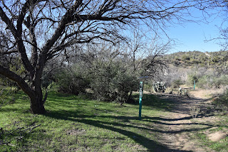
Western Gateway trails are popular with horses & hikers

Standard trail protocols dictate that horses always get the right-of-way.  Always. 
A dead juniper frames views of Mingus Mountain

Know what to do when you meet horses on the trail

Hikers and bikers are required to yield to horse traffic. But, it’s not just a matter of stepping aside.  For safety and courtesy, it’s important to know how to behave during horse encounters on the trail.

Here’s what American Trails, an organization that advances the development of diverse, high quality trails and greenways for the benefit of people and communities, recommends you should do when you meet a horse on a trail.

• Be aware of your surroundings. Ditch the headphones and watch for equine trail users.

• Stop and move aside for oncoming horses, but stay within their sight.

• Keep dogs on a short leash and under control.

• Say hello. Soft speaking signals to the horse that you are not a threat.

• Take directions from the rider.  Do not reach out, touch or interfere without permission.  Some horses enjoy interacting while others do not.

• When approaching a horse from behind, slow down and quietly announce (do not ring bells, yell or whistle) your presence and wait for instructions from the rider. A startled horse may kick, spin or bolt putting both rider and other trail uses at risk of injury.

• Wait for the horse to pass or, upon the rider’s okay, slowly walk around.

Town of Jerome visible below snow-capped mountains

These simple rules ensure happy trails for all.

The loop passes through a major drainage

For a chance to apply this course in horse sense, take a stroll on the aptly-named Stirrup-Saddle Up loop in the Western Gateway Area Trails in Sedona. 

The hike debarks from the large Girdner trailhead which has room for trailers.

A walk through a water-ravaged drainage is a highlight of the hike

Follow the Girdner trail for 0.1-mile, then veer right at the Stirrup trail junction.  Shaded by junipers and pinon pines, the easy-rated single track moves north through the riffled watershed of Dry Creek. Wonderful views of the Cockscomb formation, Doe, Bear and Wilson Mountains and the distant profiles of Mingus and Woodchute Mountains rising over the town of Jerome, provide a carousel of eye candy throughout the hike.  About a half-mile in, the trail crosses through a rough-cut drainage of sandstone slabs and red-earth walls with protruding roots exposed by flood waters.  This brief, oddly-entertaining section lands hikers on a ledge over sprawling green gullies.
Wilson Mountain viewed from the Stirrup Trail


At the 0.9-mile point, the trail meets the south terminus of the loop portion of the hike at the Saddle Up junction.  Continue north on Stirrup for another 0.7-mile, and pick up the loop at its north junction.  The 1.6-mile Saddle Up trail is rated moderate, although it’s only slightly more hilly than its counterpart. 

Cat claw and cacti populate sunny slopes

High and serpentine, the route passes through acres of thorny, high-desert vegetation. Manzanita, cat claw, yucca and cacti thrive on exposed grasslands favored by scrub jays and ravens.
R-L: Cockscomb, Doe Mtn, Bear Mtn

Where the trail bends south, trail users will catch glimpses of iconic Courthouse Butte to the south and the mighty mound of Capitol Butte looming to the east.
Capitol Butte seen from the Saddle Up trail

The last leg of the hike passes close to several private horse properties and the Gateway system has many equine access points, so stay alert and be prepared to pony up those trail etiquette protocols at a moment’s notice.

Horses always have the right-of-way on trails


LENGTH: 4.1-mile loop

RATING: moderate

ELEVATION: 4,293 – 4,550 feet

GETTING THERE:

Girdner-Cultural Park Trailhead.

From the State Route 89A/179 traffic circle in Sedona, head 4.2 miles west (go left through the circle) on 89A to Cultural Park Way (traffic signal). Turn right and continue 0.3-mile to the Girdner Trailhead on the right. Trailhead has picnic tables and a map kiosk but no restrooms or water.

INFO:

https://www.fs.usda.gov/coconino/

Sharing trails with horses:

American Trails.

https://www.americantrails.org/resources/safe-encounters-with-horses-on-multi-use-trails


Monday, January 24, 2022

Black Canyon Trail: Little Grand Canyon Segment

BLACK CANYON NATIONAL RECREATION TRAIL: LITTLE GRAND CANYON SEGMENT

Agua Fria River pools against cliffs on the Black Canyon Trail

Tucked in the hilly back county between Interstate 17 and the feeder gullies of the Agua Fria River, the Little Grand Canyon segment of the Black Canyon National Recreation Trail, offers easy access to a remote-feeling hike escape.
Big views on the Little Grand Canyon segment of the BCT

The 1.4-mile slice of the 80+-mile route that runs between the Carefree Highway in north Phoenix to the fringes of Prescott National Forest near the town of Mayer, showcases a rugged water-ravaged landscape entrenched by mountains, mesas, washes and mineral-rich foothills just over 30 miles north of downtown Phoenix.

A gate frames mesa views on the Black Canyon Trail


Named more for the presence of the Little Grand Canyon Ranch on the banks of the Agua Fria, rather than for its resemblance of the real geological deal to the state’s north, the segment delivers a pleasing rotation of eye-popping vistas served up by way of edge-hugging switchbacks and slinky single tracks.

Indian Mesa (center-left) near Lake Pleasant

Hikers should be aware that the area is also a popular draw for recreational shooting and OHV use.  Hikers can expect to hear a constant the pop-pop of rifles and the rev of quad engines during the first half-mile of the hike. 

New River Mountains viewed from LGC segment

Ironwoods and saguaros near the Little Pan junction

The trail itself is open only to foot, horse and non-electric bike travel, so the noise is soon absorbed in stony clefts and acres of pristine desert.  To find the route from the trailhead, follow the short access path to a “T” intersection, go right and hike past a chain of RV campsites. The trail is well-signed throughout.
Christmas cactus sprout red fruit in winter

Right from the start, mountain views command attention. To the southwest, the distinctive slanted flattop of Indian Mesa stands among stone sentinels at the remote upper finger coves of Lake Pleasant.  As the trail makes an easy descent along a narrow trail cut from buff-colored,

compacted volcanic ash, scaly metamorphic shelves and quartz outcroppings, views of the Bradshaw Mountains to the north peek out over vivid green foothills covered in paloverde trees, creosote, cholla and massive squads of tall saguaros. 

Trail passes by interesting geological formations

At the 1.1-mile point, the trail crosses a major wash with scoured caves and quartz-laced boulders polished smooth by years of rushing water.  To stay on track at this and all wash and drainage crossings on the hike, be sure to locate the trail signs placed on the opposite side before trudging forward.  
Bradshaw Mountains peek over foothills and saguaros

The route then passes a rustic gate and the unnamed junction for the Little Pan loop segment before making a dive into the wide flood plains and chiseled channels of the Agua Fria River. 
Approach to the Agua Fria River on the Williams Mesa segment

At this point, the trail enters its Williams Mesa segment, heading downhill on a loose-rock cliff face to meet a forest of willow and mesquite trees at the river’s edge.  The sandy waterway is  strewn with haphazard deposits of rocks, pebbles and flood debris. 
Signs guide trail users through the Agua Fria flood plains

Water in the Agua Fria River pools below the trail

Water lingers in pools below sheer cliffs and in glassy rivulets flush with spent cottonwood leaves. 
Watch for signs where the trail crosses washes and the river

The route crosses the broad desert stream and picks up where a few trail signs cling precariously to a sheer rock face where the path heads directly up and on for another 3 miles to where it connects with the Cheap Shop segment near the Little Pan staging area on Azco Mine Road. 
Williams Mesa segment climbs cliffs over the river

The river makes for a nice turnaround point for a 4.2-mile trek.  Consult the Black Canyon Trail maps for ways to build a loop or longer-distance hike in this gorgeous pocket of foothills that’s not too far from civilization.

LENGTH: 4.2 miles round trip as described here

RATING: moderate

ELEVATION: 1,699 – 1,939 feet

GETTING THERE:

Table Mesa Trailhead.

From Interstate 17, 36 miles north of Phoenix, take the Table Mesa Road exit 236.  At the end of the off ramp, turn left, go a few yards and then veer right onto Frontage Road (the unsigned west end of Table Mesa Road).  Continue to the large “Table Mesa West” sign, turn left and continue to the Table Mesa trailhead at kiosk No. 5 on the right, 3.1 miles from I-17.  Roads are maintained dirt/gravel, suitable for all vehicles.

INFO: Black Canyon Trail Coalition

https://bctaz.org