Find A Trail. Start Your Search Here:

Showing posts with label ruins. Show all posts

Monday, November 16, 2020

Black Canyon Trail to Russian Well

Black Canyon Trail to Russian Well

The working windmill at the Russian Well site

The Black Canyon National Recreation Trail is quietly expanding its northern reach.

Efforts to extend the 80+-mile historic route that stretches from Phoenix to the outskirts of Prescott are taking shape in the Verde Ranger District of Prescott National Forest.

Black Canyon Trail is expanding in the Prescott National Forest

While there are already numerous easy-access trailheads scattered along the route, plans for better connectivity and loop options in the Verde Valley are in progress. 

Scenic spot at the hike's high point

One off-the-beaten- path trailhead that’s currently open and flagged for enhancement is the Russian Well segment northeast of the town of Mayer.  Situated in stunning back country of rolling hills, washes and scrubby rangeland, this remote stretch of trail, which (as of this writing) follows a signed temporary alignment on dirt roads is also packed with relics of the area’s past.
Rustic stone structure at Russian Well

It’s a starkly beautiful, curious place with multiple personalities.  The hike starts out with a walk among low-growing pockets of mesquite, scrub oak, cacti, yucca and thickets of cat claw shrubs that punctuate largely barren grasslands.  The undulating path dips and climbs through wide open spaces where domestic cattle graze and deer might be sighted darting among scant stands of juniper trees.  At the top of the first rise, the cottonwood-lined course of Yarber Wash in a depression below cuts a ribbon of color among the muted tones of the surrounding chaparral.

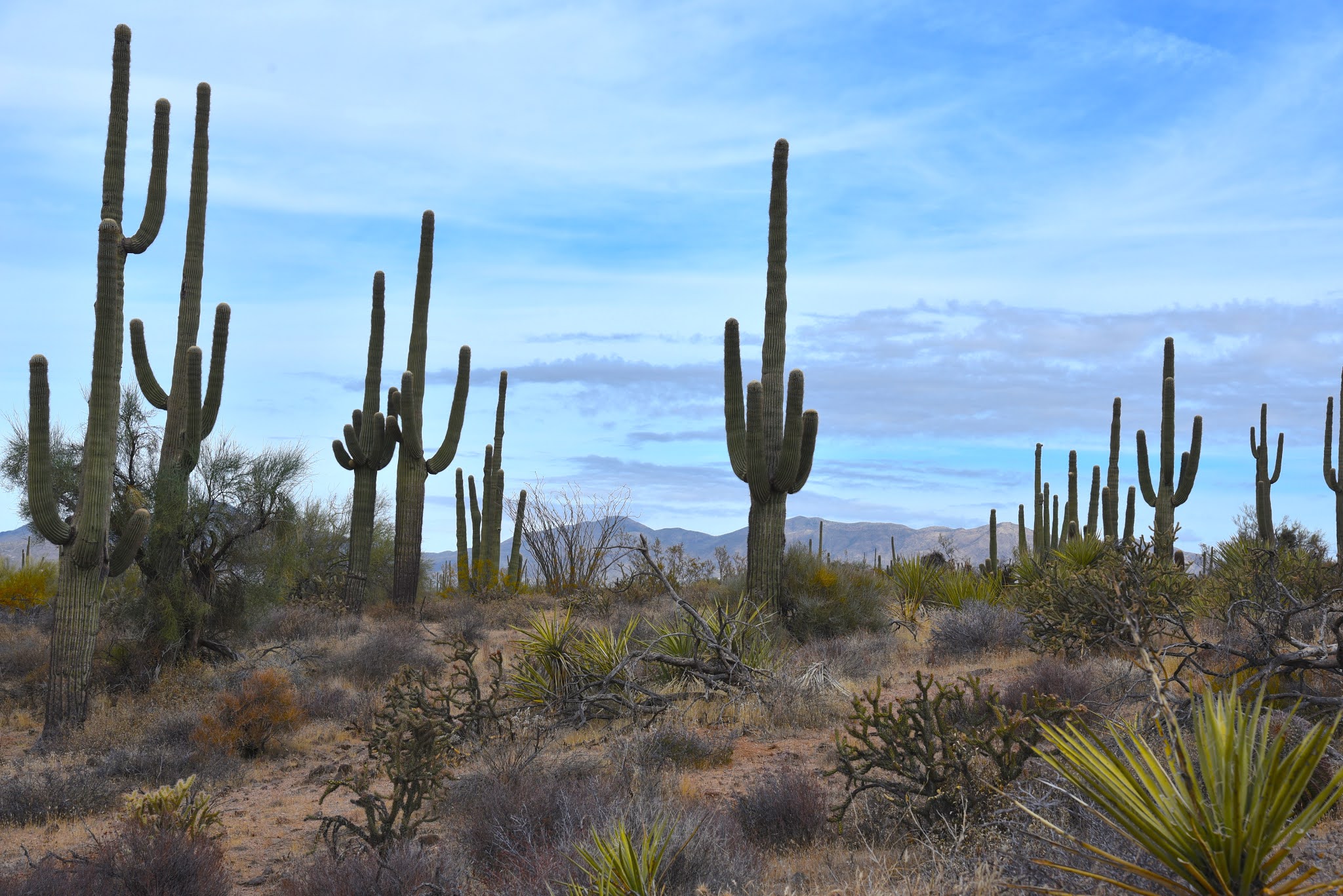
Black Canyon Trail traverses mineral-rich back country

 The road twists downhill and crosses the sandy riparian strip before heading uphill again to a cattle guard and fence line signed for U Cross Ranch. 
Russian Well site and Copper Mountain (center horizon) seen from the trail 

Another mild uphill section lands at a corral where some of the most sweeping vistas of the hike come into view. Look for the long profile of the Bradshaw Mountains in the west, Pine Mountain Wilderness to the east and the prominent peak of Copper Mountain to the southwest.  Strewn with salt licks (blocks of minerals placed for resident cattle) and strung with barbed wire, the high corral site marks the beginning of the history segment of the hike.
The trail crosses tree-lined Yarber Wash

 
Artifacts at the abandoned Tri-Metal Mine site

A water trough at Russian Well attracts wildlife

From here the road approaches the boundary of Prescott National Forest and enters Bureau of Land Management territory and dips downhill along a rough road cut that exposes some of the complex geology that attracted prospectors to mineral-rich volcanic deposits.  At the 2.9-mile point, the trail encounters an intersection above the tiny oasis of the Russian Well outpost. 

U Cross Ranch site on the Black Canyon Trail

The left fork heads up to the Tri-Metals Mine while the right spur continues downhill on the Black Canyon Trail to the well.  The Russian Well locale makes for interesting exploring.  Ringed by massive, clearly ancient junipers, the site straddles Brushy Wash, a deeply incised drainage where a working windmill pumps groundwater into a collection of tanks and an open-air water trough.  A picturesque, partially collapsed stone building surrounded by splintered timbers and metal scraps stands above a small corral at the edge of the wash. 
The corral at Russian Well

Juniper trees surround the Russian Well corral

A walk around the place reveals signs of active wildlife, including raucous, steel-blue pinion jays that flit around the water trough, and scatterings of rusted cans and odds-and-ends that reveal little about the well’s original builders except maybe they ate beans and drank beer.  As with all heritage sites, leave everything as you found it. 
Prescott National Forest mountain views abound on this hike

Russian Well is the turnaround point for this hike, however, the trail continues south on the route’s Copper Mountain segment.
Ruins of the Tri-Metal Mine prospect

It’s 10.2 miles to the next substantial access point—the Big Bug trailhead off State Route 69 near the town of Mayer.  For an out-an-back hike, there’s more to explore on the return trip.  Hike back up to the road junction and follow the opposite fork to the mine.
Scrubby rangeland dominates the hike

During its operating life, the defunct Yavapai County prospect yielded silver, gold, copper and lead.  Two filled-in digs, waste piles and a group of disintegrating concrete foundations and structures are all that remain.  You’d be hard pressed to find any remnants riches lying about, but a display of oxidized detritus like nuts, bolts and unidentifiable parts scattered among the ruins are more mundane treasures to observe in place while gazing out over layers of foothills and mountain peaks.  

LENGTH: 7.1-mile round trip as described here

RATING: moderate

ELEVATION: 4,189 – 4,517 feet

GETTING THERE:

From Phoenix go north on Interstate 17 to the Orme/Dugas Road exit 268 north of Cordes Junction.  Turn left at the bottom of the offramp and follow Orme Road (County Road 169) 7.1 miles to the trailhead on the left.  There’s a Black Canyon Trail sign at the entrance to a large dirt lot.  Hike begins at the trail post at the south side of the lot

Roads are maintained dirt suitable for all vehicles.

INFO: Black Canyon Trail Coalition

http://bctaz.org/

Wednesday, October 28, 2020

Corral Loop

CORRAL LOOP 

McDowell Sonoran Preserve

Brown's Mountain seen from Brown's Ranch Road

A mile and a half north of the busy Brown’s Ranch trailhead, a gnarled mesquite tree grows through and around the crumbling walls of concrete feed trough.  Nearby, tangled barbed wire, weather-worn and clinging tenuously to wood posts, surrounds a conglomerate of disintegrating foundations and rusty metal scraps.  

Saguaros tower over the Corral Trail

The relics are what remains of Brown’s Ranch.  Established in 1916, the 44,000 acre operation ran cattle in the mountainous desert space before being abandoned in mid-century.  The historic site, which is now part of the McDowell Sonoran Preserve, is the key attraction on the Corral Trail in the popular Scottsdale recreation hub.
Yuccas sway above Brown's Ranch Road

Desert plants grow among the ruins of Brown's Ranch

The ranch site can be reached by following Brown’s Ranch Road north to the Corral Trail.  The 2.3-mile path swings through gorgeous Sonoran Desert between the distinctive flat-top form of Brown’s Mountain (3,253 feet) and the jumbled granite mounds of Cholla Mountain (3,406 feet).  The first set of ranch ruins appear off to the left just a few yards from the road junction.  

A Phainopepla bird perched on a yucca eyes nearby mistletoe

A bird nest (usually cactus wren) built into a cholla cactus

Even with encroaching cacti, catclaw, frothy turpentine bushes and stray twigs poking through cracked stonework, the old west character is so animated here that you might expect to find cattle grazing among the ruins.  Any present-day rustlings, though, are those of browsing javelina, deer, rabbits, lizards and chattering Phainopeplas—black, red-eyed birds with head crests that resemble cardinals-- feeding on invasive mistletoe drooping from ironwood trees.

A disintegrating foundation at the Brown's Ranch site

Cholla Mountain (center) & Granite Mountain (right) seen from Brown's Ranch Road

A string of barbed wire fencing trailing off from the main site soon dissolves into thickets of jojoba bushes and spiny yucca that line the trail as it swings north and west through open desert with towering saguaros and distant views of the Cave Creek Mountains to the north and Sierra Ancha Mountains to the east.  Occasional glimpses of sagging fences are the only relics visible until near where the trail reconnects with Brown’s Ranch Road.

Blue Palo Verde trees grow along the route

Beware of the notoriously sticky "Jumping Cholla"

Navigating the trails of McDowell Sonoran Preserve is easy

The desert reclaims its territory

Cave Creek Mountains seen from Brown's Ranch Road

Here, a round cinder block structure that at one time held ranch resources now serves as a sort of giant planter for mesquite trees surrounded by untamed clusters of "jumping cholla" (Chain Fruit Cholla) that provide fodder for pack rats and nesting habitat for cactus wrens.  Tread lightly while exploring these fragile remains that are slowing being reclaimed by environmental forces and desert creatures. Leave what you find, watch where you step--there are no cow pies, but those pesky magnetic cholla stems (and snakes, maybe) can ruin your day--and enjoy the trip back in time.

LENGTH: 5.5 miles

RATING: easy

ELEVATION: 2,645 – 2,763 feet

GETTING THERE:

Browns Ranch Trailhead.

30301 N. Alma School Pkwy., Scottsdale.

From Loop 101 in Scottsdale, take the Pima/Princess exit 36, travel 6.5 miles north on Pima to Dynamite Road.  Turn right and continue 2.7 miles to Alma School, turn left and drive 1 mile to the trailhead. The preserve is open sunrise to sunset daily. There are restrooms at the trailhead.

INFO:

https://www.scottsdaleaz.gov/preserve

https://azmemory.azlibrary.gov/digital/collection/splimage/id/18/


Monday, August 6, 2018

LAND OF THE PIONEERS TRAIL #651

LAND OF THE PIONEERS
This box canyon is a highlight along the north leg of the trail.
The bucolic pastures and quiet backwoods of Vernon, Arizona--population 122--is the last place you’d expect to be the scene of a vile triple homicide. It happened, though and the sad story is standard fare in local lore.
Ruins of a pioneer homestead.
Pioneers began settling the rural community in the eastern White Mountains in the 1890s, making a living on the surrounding lumber-rich forests. 
The ruins of an infamous pioneer cabin.
Legend has it that among the early pioneers were three women who lived in a log cabin just south of town.
Section 31 Tank attracts swarms of dragonflies.
Back-fence chatter about the women hiding a large amount of money on their property eventually reached the ears of criminals.  The women were murdered and their homestead ransacked. No riches were found.  Today, all that remains of the tragic scene are crumbling stone foundations and piles of rusty-nail planks.  
Delicate Torrey's Crag Lily bloom in sunny spots.
The historic homestead is one of many points of interest on the Land of the Pioneers Trail #651 that’s located 5 miles south of Vernon.   Constructed in a customizable, triple-loop format, trail No. 651 wanders through a mix of deep pine-oak woodlands and airy, juniper-dotted meadows. The most scenic elements of the hike are found on the north leg of the 8.7-mile circumference loop.
Beautiful White Mountains views from Ecks Mountain.
Bright red paintbrush wildflowers stand out along the paths.  
From the trailhead, the north leg departs at the kiosk following a dirt road. Just past the first of several cattle gates, the trail bends left onto a single track.
A sunny section of the circumference loop.
Like all White Mountains Trail System routes, this one is very well maintained and outfitted with location markers placed roughly every quarter-mile.
Approaching the box canyon.
The markers correspond with downloadable maps, so you’ll always know where you are on the trail. White diamond tags denote the main outer loop while yellow dots indicate shortcuts for the three inner loops.  The hike to the cabin site is just over a mile. The first ruins appear at location marker L30 and the main cabin ruins are a quarter mile farther at maker L29. This is also where the shortcut for Loop 1 veers off for a 3.5-mile option. Next up on the big loop, look for a short spur path on the left near marker L26 that leads to Section 31 Tank. The secluded water hole reflects the sky and teems with multi-colored dragonflies. 
Yellow dots indicate shortcut routes.
After another 0.75-mile, the trail traces the edge of rocky box canyon with steep drop offs and first glimpses of dozens of eroding cinder cones in the Springerville Volcanic Field. This is one of the prettiest spots on the trail.  Beyond the canyon, the trail begins its ascent up the flanks of Ecks Mountain.
One of several rustic gates along the route.
To bypass this challenging section, take the signed shortcut for a 6.8-mile moderate trek. Sweat expended on Ecks Mountain and an optional short spur that leads to a vista point pays off with excellent panoramic views of Greens Peak and rolling prairies that stretch into New Mexico.
Pink Windmills bloom through September.
A set of tight switchbacks mitigate the vertical descent down to the south leg of the loop. The final miles back to the trailhead undulate through boulder-studded ravines, moist drainages and fields of wildflowers shaded by the afternoon clouds that roll in like clockwork during White Mountains summers.
Be prepared for afternoon summer storms.
LENGTH:
Circumference Loop: 8.7 miles
Loop 1: 3.5 miles
Loop 1-2 combo: 6.8 miles
RATING:
ELEVATION: 7220 – 7864 feet
Section 31 Tank is located along the north leg of the big loop
GETTING THERE:
From the junction of US 60 and State Route 260 in Show Low, go 19.4 miles east on US60 to County Road 3140 (Vernon Road/Forest Road 224). Turn right and continue 5 miles south, turn right onto Forest Road 5 and drive 0.5-mile to the trailhead on the left.  Forest roads are gravel and dirt, suitable for passenger vehicles.
INFO: White Mountains Trail System

Wednesday, July 4, 2018

WALNUT CANYON NATIONAL MONUMENT

Cultural Heritage Hikes at Walnut Canyon National Monument
View from a "shady side" dwelling
Walnut Canyon is one of Northern Arizona’s most fascinating natural wonders.  Over its 20-mile course, the 400-foot-deep gorge cuts through pine-studded plateaus and eons of Earth’s history.  
Sinagua cliff dwellings
Located just a few miles southeast of Flagstaff, the chasm’s wavy course was created over millions of years by a complicated series of geological events. The canyon’s tilted layer-cake appearance is partly made up of eroded limestone deposits and the lithified remains of ancient coastal sand dunes. 
Edible mahonia (barberry) also has medicinal qualities.
Although you’d need a Ph.D. to thoroughly understand its geological anatomy, the canyon’s more relatable human element is the focus of a hike along the trails of Walnut Canyon National Monument. 
240 stairs descend to the Island Trail
The park was established in 1915 to protect and preserve the cultural artifacts of the Sinagua people who built and occupied cliff dwellings in the canyon’s ledges and shallow caves between 1100-1250.  Two educational hikes offer lessons in biodiversity, geology, traditional farming methods and human history.  The Island Trail begins with a steep, 185-foot descent on a stone staircase with dizzying views. The trail swings around a rock jetty where dozens of stone-and-mortar rooms are built into crags and overhangs. Interpretive signs provide information about the structures as well as native plants and animals. 
View of Walnut Canyon from the Rim Trail
Dwellings on the Island Trail
The west or “shady side” of the jetty is smothered in towering Douglas firs, ponderosa pines, mahonia and Arizona walnut trees that thrive in the cooler, wetter microclimate.  Around the bend, the path emerges onto the “sunny side” -- an exposed ledge where the plant life reflects dryer, warmer conditions. Cacti, yucca and pinion pine cling to chiseled escarpments.  From here, views of the visitor center high above, reminds that there’s a strenuous 240-step climb out to get to the next trail.  
Pueblo on the Rim Trail
Back up on the brow of the gorge, the Rim Trail makes an easy half-mile loop to scenic overlooks, a pit house, pueblo and demonstration garden. Once done with the hikes, stop by the visitor center to augment your experience by viewing displays of archeological finds and a beautiful video about the area’s natural history.
Stairs descend 185 feet to the Island Trail
LENGTH:
Island Trail: 1-mile roundtrip
Rim Trail:  0.7-mile roundtrip
RATING:

Island Trail: difficult
Rim Trail: easy, partially paved.
ELEVATION: 6690 – 6505 feet
GETTING THERE:
From the Interstate 17/40 intersection in Flagstaff, go 7.5 miles east on I-40 to exit 204, turn right and continue 3 miles to the site.  There is an entrance fee.
NOTE:  Temporary closures of the Island Trail may be implemented during fire season when red flag warnings are issued by the National Weather Service.
INFO: