

 V-BAR-V RANCH & SACRED MOUNTAIN
Coconino National Forest, near Sedona
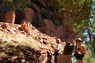
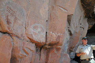
In terms of both physical presence and historical significance, Sacred Mountain really stands out. A lone white limestone massif jutting from a bowl-like basin surrounded by stark red and black cliffs makes a bold impact on the landscape and holds many secrets of Arizona’s native peoples. The focal point of what archeologists refer to as Sacred Mountain Basin, the 300-foot-high flat-topped mesa was home to a farming community of Sinagua people between the 12th and 15th centuries. The hilltop living space included dozens of rooms and a central courtyard with expansive views of what we now call Wet Beaver Creek, Montezuma Well and the Verde Valley. The ruins are highly eroded, however, the crumbling foundations hint at the footprint of the vanished community. Underfoot, pottery shards are plentiful, including some with an unusual, rich black patina. Archeologists continue to study this area and have determined that the fields below the mountain supported abundant food and fiber crops. Remains of ball courts tell a story of people who not only worked hard, but also liked to play hard. The Sinagua also used sophisticated mathematical and astronomical tools to measure time, seasons and build accurate solar calendars. Evidence of this can be seen at nearby V-Bar-V Heritage Site where panels of petroglyphs are believed to document ceremonial traditions, hunting magic and the trajectory of the sun over the horizon.
The best plan for appreciating all the wonders of Sacred Mountain Basin is to begin by visiting V-Bar-V Ranch. Here, exploring the petroglyphs is by guided tour only---the site is kept under lock and key, because, as we know, some people think it’s fun to deface national treasures. Guides are very knowledgeable and can answer most questions about the rock art---remaining questions are easy to research if you purchase one or more of several (reasonably priced) books available at the site visitor center. Once you’ve learned about the petroglpyhs and a bit about the Sinagua life ways; head over to Sacred Mountain.
At the trailhead, pass the barbed-wire gate (close it behind you) and pick up the footpath that parallels the fence. The rest of the trail is obvious. On the summit, carefully explore at will, being careful to respect the fragile nature of this special place.
AS WITH ALL ARCHEOLOGICAL SITES, IT IS ILLEGAL (not to mention, just plain ignorant & disrespectful) TO REMOVE OR ALTER ANYTHING. Leave the artifacts as you found them and don’t climb, sit on or attempt to “reconstruct” the walls.
LENGTH:
V-Bar-V: 1-mile roundtrip.
Sacred Mtn: 1-mile roundtrip.
RATING:
V-Bar-V: easy.
Sacred Mtn: moderate.
ELEVATION:
V-Bar-V: 3,800 feet (flat)
Sacred Mtn: 3,800 – 4,100 feet
BEST SEASON: September - May
FEES: a Red Rock Pass (or equivalent) is required.
http://www.fs.fed.us/r3/coconino/contact/redrock-index.shtml, (928) 282-4119
HOURS: V-Bar-V ranch is open 9:30 a.m. to 3:00 p.m. Friday, Saturday, Sunday and Monday only. Closed Thanksgiving & Christmas.
GETTING TO V-BAR-V HERITAGE SITE:
From Phoenix, go north on I-17 to exit 298 (Highway 179 for Sedona-Oak Creek). Go right (east) on Hwy 179 (FR 618) and continue 2.7 miles to the turn off for the site. Park in the lot above the ranch and hike down to the visitor center where you must sign in and meet your guide.
GETTING TO SACRED MOUNTAIN:
From the V-Bar-V Ranch, go back out onto FR618, turn right and drive 0.5 mile to FR 9201A. Turn left and follow the rutted dirt road 0.2 mile (or as far as you dare) to a barbed wire fence and gate. Park at or near the gate.
INFORMATION:
http://www.redrockcountry.org/recreation/cultural/v-bar-v.shtml
(928) 282-3854


 V-BAR-V RANCH & SACRED MOUNTAIN
Coconino National Forest, near Sedona
In terms of both physical presence and historical significance, Sacred Mountain really stands out. A lone white limestone massif jutting from a bowl-like basin surrounded by stark red and black cliffs makes a bold impact on the landscape and holds many secrets of Arizona’s native peoples. The focal point of what archeologists refer to as Sacred Mountain Basin, the 300-foot-high flat-topped mesa was home to a farming community of Sinagua people between the 12th and 15th centuries. The hilltop living space included dozens of rooms and a central courtyard with expansive views of what we now call Wet Beaver Creek, Montezuma Well and the Verde Valley. The ruins are highly eroded, however, the crumbling foundations hint at the footprint of the vanished community. Underfoot, pottery shards are plentiful, including some with an unusual, rich black patina. Archeologists continue to study this area and have determined that the fields below the mountain supported abundant food and fiber crops. Remains of ball courts tell a story of people who not only worked hard, but also liked to play hard. The Sinagua also used sophisticated mathematical and astronomical tools to measure time, seasons and build accurate solar calendars. Evidence of this can be seen at nearby V-Bar-V Heritage Site where panels of petroglyphs are believed to document ceremonial traditions, hunting magic and the trajectory of the sun over the horizon.
The best plan for appreciating all the wonders of Sacred Mountain Basin is to begin by visiting V-Bar-V Ranch. Here, exploring the petroglyphs is by guided tour only---the site is kept under lock and key, because, as we know, some people think it’s fun to deface national treasures. Guides are very knowledgeable and can answer most questions about the rock art---remaining questions are easy to research if you purchase one or more of several (reasonably priced) books available at the site visitor center. Once you’ve learned about the petroglpyhs and a bit about the Sinagua life ways; head over to Sacred Mountain.
At the trailhead, pass the barbed-wire gate (close it behind you) and pick up the footpath that parallels the fence. The rest of the trail is obvious. On the summit, carefully explore at will, being careful to respect the fragile nature of this special place.
AS WITH ALL ARCHEOLOGICAL SITES, IT IS ILLEGAL (not to mention, just plain ignorant & disrespectful) TO REMOVE OR ALTER ANYTHING. Leave the artifacts as you found them and don’t climb, sit on or attempt to “reconstruct” the walls.
LENGTH:
V-Bar-V: 1-mile roundtrip.
Sacred Mtn: 1-mile roundtrip.
RATING:
V-Bar-V: easy.
Sacred Mtn: moderate.
ELEVATION:
V-Bar-V: 3,800 feet (flat)
Sacred Mtn: 3,800 – 4,100 feet
BEST SEASON: September - May
FEES: a Red Rock Pass (or equivalent) is required. http://www.fs.fed.us/r3/coconino/contact/redrock-index.shtml, (928) 282-4119
HOURS: V-Bar-V ranch is open 9:30 a.m. to 3:00 p.m. Friday, Saturday, Sunday and Monday only. Closed Thanksgiving & Christmas.
GETTING TO V-BAR-V HERITAGE SITE:
From Phoenix, go north on I-17 to exit 298 (Highway 179 for Sedona-Oak Creek). Go right (east) on Hwy 179 (FR 618) and continue 2.7 miles to the turn off for the site. Park in the lot above the ranch and hike down to the visitor center where you must sign in and meet your guide.
GETTING TO SACRED MOUNTAIN:
From the V-Bar-V Ranch, go back out onto FR618, turn right and drive 0.5 mile to FR 9201A. Turn left and follow the rutted dirt road 0.2 mile (or as far as you dare) to a barbed wire fence and gate. Park at or near the gate.
INFORMATION:
http://www.redrockcountry.org/recreation/cultural/v-bar-v.shtml
(928) 282-3854


