BADGER SPRINGS WASH
Agua Fria National Monument
 |
| Confluence of Badger Springs Wash & Agua Fria River |
 |
| Petroglyphs along Badger Springs Wash Trail |
Anybody who has travelled Interstate 17 between Phoenix and Prescott has inevitably sped past the Agua Fria National Monument. The placid rolling hills and boulder fields that are visible from the freeway belie a wilderness of wind-swept grasslands, deep canyons, extinct volcanic features and hundreds of historical resources.
Proclaimed a national monument by President Bill Clinton in 2000, the 70,900-acre, Bureau of Land Management supervised tract is rich in Native American cultural sites that date to between 1250 and 1450. A.D.
The remains of more than 400 structures and petroglyph (rock art) panels dot the area. Although most of these delicate and irreplaceable sites reside off-the-radar far from even the worst of the rough roads that criss-cross the monument’s remote mesas and tree-lined drainages, two official trails offer short hikes to some of the area’s most impressive sights. For those with a high-clearance vehicle and the fortitude to get through a white-knuckle section of edge-clinging dirt road, the massive footprint of Pueblo La Plata on the rim of Perry Mesa above Silver Creek offers walkable exploring. But for a longer, tougher hiking experience, take the Badger Springs Wash Trail.
 |
| Hikers on the Badger Springs Wash Trail |
 |
| Steep cliffs flank the Agua Fria River |
 |
| Willows and cottonwoods thrive in the moist sandy soil. |
 |
| Trees on Badger Springs Wash Trail turn gold in early winter |
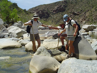
Located just over a mile from the freeway, the mile-long trail follows a sandy drainage corridor that empties into the Agua Fria River. Just before trail’s end, petroglyph panels on crags flanking the wash’s east side bear dozens of etchings of animals, humans and artful designs. As with all archeological resources, please to not touch, alter or remove anything. The river’s edge marks both the end of the official route and the beginning of a memorable backcountry adventure into a steep-walled gorge with numerous obstacles. Hiking beyond the confluence of the wash and the river is safe to do only when water levels are low. Do not attempt this hike during rain storms as there is a high potential for deadly flooding. Also, during very wet periods, the route may be impassible.
 |
| Perry Tank Canyon seen from Richinbar Mine |
 |
| Petroglyphs date to between 1250 and 1450 A.D. |
 |
| High water levels foiled our canyon exploration on 12-8-18. |
 |
| When accessible, the canyon hike is rocky and challenging |
Highly-skilled, properly outfitted trekkers can opt to continue slogging through either canyon, but for a day hike, this makes for a good turn around point.
 |
| Running water scribbles lacy rivulets in Badger Springs Wash |
LENGTH: 1-mile to the river
RATING: easy, then difficult
ELEVATION: 3100-2900 feet
GETTING THERE:
From Phoenix, travel 40 miles north on Interstate 17 to the Badger Springs Road exit 256.
Continue 1 mile east to the trailhead. A high-clearance vehicle is recommended on the rough dirt and gravel road.
INFO:
Bureau of Land Management
Friends of the Agua Fria National Moument