Find A Trail. Start Your Search Here:

Showing posts with label Mesa. Show all posts

Tuesday, November 26, 2024

Twisted Sister-Big Sister Loop

TWISTED SISTER-BIG SISTER LOOP

View of Red Mountain from Big Sister Trail
See this story on AZCentral: https://www.azcentral.com/story/travel/arizona/hiking/2024/12/13/hawes-trail-system-twisted-sister-trail/76888922007/

With its big bends, sharp declines, tight edges and hairpin turns, the Twisted Sister Trail embraces its bike-borne heritage.

Salt River Valley seen from Twisted Sister Trail

The rollercoaster-like trail is part of the Sonoran Desert (Hawes) Trail System in Tonto National Forest.  Located between the Salt River and Usery Mountains in Mesa, the system has several access points along Usery Pass Road and Bush Highway.
The Big Sister Trail is all about rocks.

 
Four Peaks viewed from the Twisted Sister Trail

The collection of looped singletrack paths began its evolution from from old livestock and mining trails with the development of the (unofficial) Hawes Trail in 1989. 
Vintage aircraft sometimes fly over the area

In 2005, the trail and several formerly unsanctioned connected routes were adopted into the Tonto National Forest system.   With the combined efforts of the forest service and the  Hawes Trail Alliance, a non-profit organization dedicated to the system’s maintenance, sustainability and future expansion of  the popular recreation hub now has over 60 miles of shared-use routes.
Red Mountain stands over the Salt River

When used as part of a loop hike, the Twisted Sister Trail makes for a moderate-rated hike with outstanding mountain vistas and peeks at the leafy corridor of the Salt River. 

Hawes Trails are well signed

The trek begins with a short walk on the Bush Lite West trail to connect with the Wild Horse Trail that’s part of the Valley-circling Maricopa Trail. 
The green corridor of the Salt River from Wild Horse Trail

At the 0.2-mile point, Twisted Sister spins off to the right and begins its undulating run through saguaro-studded desert in the foothills below the Usery Mountains.  Once through a couple of slippery downhills and wash crossings the route trudges uphill, revealing grander views at each turn.  The massive form of 2,832-foot Red Mountain (also known as S-wegi Do’ag in O’odham, Wi:kawatha in Yavapai and Mount McDowell, Fire Rock and Gunsight Butte) is a constant presence on the west side of the river on the Salt River Pima-Maricopa Indian Community at the confluence with the Verde River.  To the north, iconic Four Peaks hover over the mountains of Tonto National Forest and on the distant west horizon, Camelback Mountain rises above city haze. After just under a mile of steady but not-to-tough climbing, the trail meets a three-way junction.
Saguaros and boulders on Big Sister Trail

Mountains of Tonto National Forest on horizon

For a short loop hike, veer left onto the Big Sister Trail.  Whereas Twisted Sister was all about views, Big Sister is all about rocks.  Clinging to boulder-strewn slopes, the slim path weaves through impressive globs of granite, boulder ridges and natural stone sculptures.  Midway through the 1-mile return leg, the trail gives up the widest-angle views of the Salt River Valley and on lucky days, grazing wild horses and vintage aircraft from The Commemorative Air Force Aviation Museum can be spotted flying overhead. 

LENGTH: 3.6 miles

RATING: moderate for hiking, difficult for bikes

ELEVATION:  1,387 – 1,793 feet

GETTING THERE:

From U.S. 60 in Mesa, take the Power Road exit 188 and continue north (Power Road turns into Bush Highway) to the Wild Horse trailhead on the right between mile posts 23 and 24.

INFO:

https://www.fs.usda.gov/tonto

https://hawestrailalliance.com/


Monday, November 22, 2021

Pass Mountain Trail

PASS MOUNTAIN TRAIL

Goldfield Mtns & Four Peaks seen from Pass Mtn

In terms of sensory overload, the Pass Mountain Trail works sort of like an old-style 5-disk CD changer to deliver a cycle of ever-changing delights that once engaged, just keeps on spinning.

Approaching the east flanks of Pass Mountain

The 7.5-mile route that loops through both Usery Mountain Regional Park in Mesa and the urban-wildland interface of Tonto National Forest, packs in the hiking equivalents of mellow slow dance vibes, sultry tangos and pounding hip-hop rhythms. 

Mountain and valley vistas abound on Pass Mtn

An edgy section of the Pass Mtn Trail

Accessible by way of convenient trailheads in the park, the rocky single track blends low desert strolls, a carousel of vistas and just enough raw mountain exposure to serve up one of the most diverse, close-to-town hikes in the Metro Phoenix area.
A close-to-town hike with wilderness vistas
  Park rangers recommend taking on the loop from either the Wind Cave or Horse Staging trailhead in a clockwise rotation (begin by going left) for a longer but milder ascent to the hike’s scenic saddle.  For those who just want to get to the high point vista and then double back, that’s the ticket, however full-loop hikers should consider a counterclockwise (go right) approach.
Tangles of Sonoran Desert vegetation on Pass Mtn

It’s harder that way, but it gets the difficult climbing over quicker and eliminates the chore of negotiating a steep, slippery down climb on tired legs.

Pass Mtn viewed from the park side of the trail

  Heading right from the Wind Cave trailhead, the trail almost immediately exits the park boundary and enters Tonto National Forest. 
Lichens color the cliffs of Pass Mountain

The first relatively flat half-mile runs through classic desert vegetation and ruffled washes in the shadow of the pyramid-shaped Cat Peaks.  
A slickrock passage leads to a scenic saddle

Over the next mile-and-a-half, views of the Superstition Mountains rising above the town of Apache Junction command the eastern horizon as the trail makes a northward bend and a barely noticeable ascent toward on the mountain’s east face. 
Approaching the U-shaped saddle on Pass Mtn

Residual glimpses of rooftops and roads are soon swallowed up in the folds and drainage cuts of the mountain’s wild side. 
Stunning views from the Pass Mtn saddle


A valley flush with saguaros sits below the destination—a U-shaped pass visible on the north ridgeline.  The climb to get there isn’t too difficult until about a half-mile from the top where the route hangs on precipitous edges and a slickrock ledge for an appetizer of adrenaline before the trail emerges on the prize. 
The trail heads north from the saddle

Bam!  The wind-in-your-face jolt of stepping onto the 2,593-foot saddle is a jaw-dropping experience.  With a single bend in the trail, the vistas make an explosive transition from saguaros and suburbs to layers of mountains and river valleys.
A saguaro-cluttered valley precedes a steep climb

Mesquite and Palo verde trees shade the lower trail

 
In the foreground, the blocky, colorfully-layered Goldfield Mountains rise above a scoured divide.  Behind them, are the iconic Four Peaks and rows of wilderness peaks stand over the Salt River Valley.  
Another view of the saddle approach

View of the saddle on the right ridgeline

Save for some minor drainage crosses and exposure the remainder of the trail is just a moderate trudge that hugs the mountain’s eastern flanks, unspooling views of the Usery Mountains and hazy peeks at the McDowell range near Scottsdale before it swings south and descends to the base of Pass Mountain for the final 2-mile walk back to the trailhead.
Superstition Mountain views


LENGTH: 7.5-mile loop

RATING: difficult

ELEVATION: 1,866 – 2,598 feet

GETTING THERE:

Usery Mountain Regional Park,

3939 N. Usery Pass Rd., Mesa.

From U.S. 60 in Mesa, take the Ellsworth Road exit 191. Go 6.7 miles north on Ellsworth (which will turn into Usery Pass Road) to the Usery Mountain Regional Park entrance on the right.  The tail may be accessed from the Wind Cave and Horse Staging Area trailheads.  There are restrooms at both trailheads.

FEE: There’s a $7 daily fee per vehicle payable at the park entrance. 

INFO: https://www.maricopacountyparks.net/usery-mountain-regional-park-um/


Monday, December 4, 2017

Wild Horse-Maricopa Trail Usery Mountains Segment

Wild Horse-Maricopa Trail Usery Mountains Segment
Cholla cacti are abundant along the Wild Horse Trail
The Salt River Recreation Area north of Mesa is a well-known destination for kayaking, tubing, fishing and picnicking. Although there are also some hiking trails near the water, riverside commotion, noisy crowds, entry fees and mounds of trash left behind by careless day trippers are buzz kills for trekkers in search of beauty and solitude. However, a nearby system of trails that overlooks the area offers peaceful wandering. 
Four Peaks as seen from the trail.
The Sonoran Desert (Hawes) Trail System in Tonto National Forest has more than 20 miles of interconnected paths located between Usery Pass Road and Bush Highway just south of the popular recreation area.  The northern-most route in the system is the Wild Horse Trail which is also part of the Valley-circumnavigating Maricopa Trail. As its name suggests, the trail passes through the domain of wild horses. 
Saguaro skeletons add interest to the hike
The elegant and sometimes controversial beasts can be spotted wading in the river, poking around in the riparian corridors and grazing in the surrounding desert foothills.  Regardless of where you might see them, it’s smart to keep your distance and enjoy the herds from afar.  The Wild Horse/Maricopa Trail escapes the din of the crowds and  is also high enough in the hills to afford inspiring vistas of the Salt River Valley, Four Peaks, Red Mountain and the Usery Mountains. Staring from the trailhead on Usery Pass Road, the trail heads out through wide washes and scoured gullies. You’ll cross an old “NRA pit” where rusting bullet casings, broken glass and other relics of target shooting activities remain in the sandy, buffered depression.
Overlooking the Salt River Valley
Shooting is no longer allowed there, but the sounds of gunfire can be heard from the Usery Mountain Shooting Range to the south.  Once through the pit area, the pop-pop of rifles and revolvers is muffled by a corrugated terrain of arroyos, ravines and gently rolling hills. Beyond the half-mile point, the hike takes on a surprisingly remote feel. The green band of the Salt River snakes through a chiseled landscape to the north, then arches south where it wends around Red Mountain in the Granite Reed Dam area.  The trail bears the hallmarks of its mountain biker origins. 
View of the Salt River near Bush Highway
Hairpin turns, swooping stretches and lots of swift-and-smooth roller coaster segments make for an ever-changing hike with surprises around every bend.  What little shade the trail has is provided by pockets of ironwood and Palo Verde trees that thrive in water-whittled ravines.  Another noteworthy botanical attraction here is a smattering of saguaro cacti skeletons in various stages of decomposition.  
A brief section with shade

Their woody cores with sponge-like patterns and haunting postures lie bare the internal structure of Arizona’s iconic plant.  The Wild Horse Trail ends at the 3.3-mile point but you can continue hiking on the Maricopa Trail for another 4.2 miles to Bush Highway for watery views and the best chance to see mustangs in the mist.
 Maricopa Trail and Wild Horse Trail follow the same route
LENGTH: 3.3 miles one way for Wild Horse Trail or 7.5 miles one way for Maricopa Trail section to Bush Hwy.
RATING: easy
ELEVATION:  1320' - 1880'
GETTING THERE:
From US 60 in Mesa, take the Ellsworth Road exit 192 and go 9 miles north (Ellsworth turns into Usery Pass Road) to the Wild Horse trailhead on the left. The trailhead is marked by a Maricopa Trail sign and a no-shooting post. There’s space for about 6 vehicles in the dirt turnout parking area.
Red Mountain 
Maricopa Trail:
Maricopa Trail & Park Foundation
Global Bikes Sonoran Desert (Hawes) Trail System Maps

Monday, September 12, 2016

Wag & Walk Dog AdoptionHikes Return Oct. 1, 2016

WAG & WALK DOG ADOPTION HIKE
Usery Mountain Regional Park


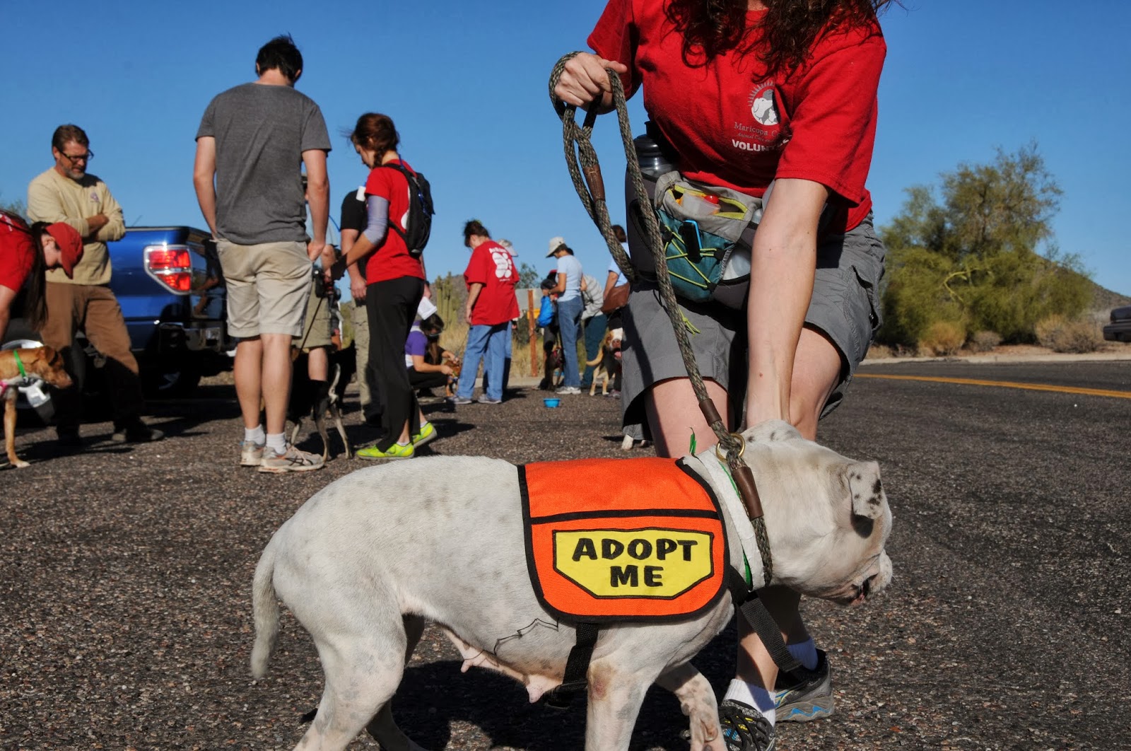
Ruh Roh, make way for the pups! Cuddly canines from the Maricopa County Animal Care & Control east shelter will be hitting the trail again on Saturday October 1st for the 2016-17 premier of Wag & Walk dog adoption hikes. Come on out to beautiful Usery Mountain Regional Park in Mesa and join the dogs on the easy, 1-mile Merkle Trail. Each dog will be accompanied by a volunteer handler who can tell you all about the animal's breed, personality, activity level and history at the shelter. You may also "test drive" the dogs to see how they handle on leash. This is a great opportunity to meet adoptable pets in a relaxed environment where they're more likely to display their loveable vibes. All dogs are already spayed or neutered, are up-to-date on their shots and ready to go directly into their new forever homes. You don't have to be in the market for a new fur baby to join the fun, though.
There will be lot's of information on hiking with dogs, shelter services and how you can sign up to become a volunteer. What could be better than celebrating the beginning of prime hiking season with a bunch of butt wagging dogs?
WHEN: Saturday, Oct. 1, 2016 and every 1st Saturday of the month Oct. - April.
TIME: 9 a.m.
WHERE: Usery Mountain Regional Park. 3939 N. Usery Pass Rd., Mesa. Merkle Trailhead Area 6.

Monday, September 21, 2015

BULLDOG SEGMENT of the MARICOPA TRAIL

MARICOPA TRAIL
Bulldog Canyon Trailhead to Pass Mountain Trail
Granite outcroppings on Maricopa Trail

Loop trails are fantastic inventions. Hiking on one feels sort of like a following a cinematographer filming a visually-rich sequence that ends where it began. Arizona has some impressive hiking hoops. Revered for their flowing, long lengths and community-unifying qualities, projects like the Flagstaff Loop Trail (42 miles), Prescott Circle Trail (54.4 miles) and the grand dame of them all--Maricopa Trail-- act as the glue for regional, non-motorized recreation systems. When complete (target 2017), the Maricopa Trail will form a 310-mile loop around Greater Phoenix, connecting parks, suburbia and surrounding cities. The thrill of trekking on fresh dirt is rekindled each time a new segment drifts into pristine tracts or provides an alternate path to familiar hiking haunts. With the recent opening of a 1.4-mile section in the East Valley, there's now another way to approach the popular Pass Mountain (PM) Trail. Previously, access to PM was only though Usery Mountain Regional Park or a lot off Meridian Road in Mesa. This new western approach from Bulldog Canyon Trailhead will eventually tie in with a yet-to-be-constructed corridor to the Granite Reef recreation area near the Salt River. Volunteers are needed to complete the work and you can sign up to be part of this historic effort by visiting the Maricopa Trail + Park Foundation website: http://mctpf.org/.
The "Bulldog" segment makes an easy, 300-foot ascent to the junction with 7.5-mile PM Trail (not signed). Roughly 5.6 miles of the PM loop trail is on the Tonto National Forest and there's no fee to hike on this scenic section. However, if you cross into the part of the trail that's in Usery Mountain Park, be prepared to pay the $2 per person fee (exact change required). You can avoid the fee by heading left at the junction. From here, its just under 2 miles to the saddle overlooking a valley straddling the desert space between the Superstition and Goldfield Mountains. This makes for a good turn around point for those left their wallets at home or are not up to the 10.3-mile circuit.
LENGTH: 1.4 miles one way (trailhead to PM)
or 10.3 miles roundtrip with Pass Mountain Loop
RATING: easy-difficult
ELEVATION: 2,010'- 2,340' (2,740' with PM)
FEE: $2 per person if you enter the park on foot. Exact change required.
GETTING THERE:
From Phoenix, go east on US60 to the Ellsworth Road exit. Go north 8.2 miles north on Ellsworth (turns into Usery Pass Rd.) to the trailhead corral on the right past milepost 22 which is 1.6 miles north of the Usery Mountain Park entrance.
Maricopa Trail:
Maricopa Trail + Park Foundation:
MORE PHOTOS:

Sunday, November 23, 2014

SONORAN DESERT (HAWES) TRAIL SYSTEM


SONORAN DESERT (HAWES) TRAIL SYSTEM
Tonto National Forest, Mesa Ranger District
Salt River viewed from Saguaro (aka Mine) Trail

Originally constructed by mountain bike enthusiasts, this intertwining system of trails overlooking Granite Reef Dam on the Salt River in Mesa is just too interesting for hikers to ignore.  In 2005, 10.3 miles of the 20-mile web of social trails were adopted into the Tonto National Forest System. As would be expected of bike trails, these routes offer an entertaining mash up of twists and swooping turns tracing the site’s hills and valleys. The 5-trail maze is also known as the "Hawes System" after the longest route in the mix. As bikers heavily use these trails, hikers should stay alert and share the dirt accordingly. Trail courtesy dictates that bikers yield to hikers and everybody yields to horses---especially the wild mustangs that roam this riverside terrain. However, a bike careening through a hairpin turn at break neck speed won't necessarily be able to avoid you without drawing blood. So, although riders on these trails are generally courteous and careful, be prepared to relinquish the right of way whenever possible---after all, they were here first.
LENGTH: 10.3 miles (maintained trails only)
Hawes Trail #52: 3.4 miles
Ridge Trail #59: 1.7 miles
Granite Trail #54: 0.7 mile
Saguaro Trail #50: 3.1 miles
Saddle Trail #51: 1.4 miles
RATING: moderate
ELEVATION: 1150’ – 1760’
GETTING THERE:
From Phoenix go east on Loop 202 to exit 23 for Power Road in Mesa.  Travel 2.1 miles north on Power Road to the Hawes Trailhead on the left. Trail begins across the road.
INFO & MAPS: Global Bikes
Tonto National Forest
MORE PHOTOS:

Sunday, November 16, 2014

BUTCHER JONES TRAIL


BUTCHER JONES TRAIL
Saguaro Lake
Trail near Camper Cove

Of the sting of reservoirs tethered by the Salt River 30 miles northeast of the Valley, amenity-rich Saguaro Lake is the closest and easiest to find. This is one of the reasons why it's so wildly popular for boating, fishing or simply bonding with a cooler and juicy novel under a lakeside mesquite tree. Hikers can hit the dirt here by way of the Butcher Jones Trail that wraps around a water-piercing peninsula with secluded coves. Most of the route hugs the cliffs high above the lake, but fisherman paths to the shore make nice scenic detours for photography, wildlife spotting or a cozy lunch break. The trail's high points reveal fantastic views of the gaping Salt River Canyon, 1930s-era Stewart Dam and surrounding mountain ranges. Arrive early to get a good parking spot and be prepared to share the trail with pole-toting anglers and gaggles of kids running off their hot dogs and Kool-Aid. If noise and crowds cramp your style, hang in there---the commotion dissipates where the trail makes a hairpin turn around Peregrine Point.
LENGTH: 5 miles roundtrip
RATING: moderate
ELEVATION: 1529' - 1600'
FACILITIES: restrooms, picnic tables
FEE: Tonto Pass is required. $6 daily fee
GETTING THERE:
From Mesa, go 27 miles north on SR87 (Beeline Highway) to exit 199, Bush Highway (FR204), turn right and continue 2 miles to the signed turnoff for Butcher Jones Recreation Area.  Follow the access road (FR116) 2 miles to the site.  Trail begins at far east end of the beach.
INFO: Tonto National Forest
MORE PHOTOS:

Saturday, February 1, 2014

EARTH & SKY at USERY MOUNTAIN PARK


MOON ROCK TRAIL & THE STAR IN ORION'S ARMPIT
Usery Mountain Regional Park

Moon Rock Trail

Admit it--this trail's name got you wondering, right? So, is the tread way littered with lunar debris? Sort of.  According to park Interpretive Ranger Brennan Basler "Ranger B", the trail's moniker derives from the fact that both moon rocks and those that line this trail are igneous in origin. So, except for stronger gravity, the foot feel here would be similar to what the Apollo astronauts experienced.  Additionally, the park has much to offer geology and astronomy buffs. On the terrestrial level, the park is situated in the complex volcanic landscape of the Goldfield Mountains. The rugged terrain was created by fiery eruptions, lava flows, churning magma cauldrons and waves of ash laid down layer-cake-style over millions of years. This part of the earth is quieter these days, and although the rock's rough-edges are being smoothed by the elements and adorned by Sonoran Desert life, the area's natural history is preserved in trailside cliffs and gullies.
Above the park, a nighttime canopy of stars and planets is celebrated with an astronomy expert during stargazing events. The final telescope-peeping night out of the season will be held Saturday, Feb. 22, 2014 which is the perfect time to view a waning moon, and the planet Jupiter hovering above constellation Orion--the club and shield-wielding hunter.  Orion dominates the winter sky and includes one of the largest objects in the universe visible to the naked eye---the star Betelgeuse (say: beetle juice) in its armpit. The variable red super giant’s girth is about 1000 times that of our sun and if it were placed at the center of our solar system, it would engulf Mercury, Venus, Earth, Mars and maybe even Jupiter. But, get out there to see it soon--it's nearing the end of its stellar lifecycle and will likely explode in super nova style in the next few thousand years, which in geological time, is tantamount to a wink.
Blevens Trail

LENGTH:  3.5-mile loop
RATING: easy
ELEVATION: 1860’ – 1895’
FEE: $6 daily fee per vehicle
GETTING THERE: 3939 N. Usery Pass Road, Mesa AZ
SUGGESTED HIKE USING MOON ROCK TRAIL:
From the trailhead staging area, hike 0.5-mile west on Blevins Trail (BL), connect to Moon Rock (MR) and continue 1.3 miles to Levee Trail (LV). Follow LV 0.5 mile to Crismon Wash Trail (CR-W), turn north (left), hike 0.9 mile back to BL, turn right and go 0.3 mile back to the trailhead.


STAR GAZING EVENT: Saturday, Feb. 22, 2014 at 7:30 p.m. Group Picnic Area D.  Bring a lawn chair and dress warmly. No registration required.  No pets.
INFO: Usery Mountain Regional Park, 480-984-0032

Thursday, December 19, 2013

Next "Wag & Walk" dog adoption hike is January 4, 2014!


"WAG & WALK" DOG ADOPTION HIKE
Usery Mountain Regional Park
"Oreo" participated in the December hike

Take a hike with a pack of adoptable dogs from Maricopa County Animal Care’s Mesa shelter on Saturday January 4, 2014 starting at 9:00 a.m.. In addition to being exceptionally cute and sweet, “Wag & Walk” hiker dogs are already spayed or neutered and available to go home on the spot, usually at greatly reduced adoption fees.  Even if you’re not looking for a new fur baby, hiking with a group of tail-wagging dogs who are ecstatic about getting out of their kennels for some much needed exercise makes for a memorable morning in the desert. Also, everybody who adopts one (or more) of the hiker dogs will be eligible to win free county park passes!  PLEASE JOIN US.  NO REGISTRATION---JUST SHOW UP.

"Bugle" was adopted!!

LENGTH: Merkle Trail: 1-mile loop
ELEVATION: 1950'
RATING: easy, barrier-free
FEE: $6 park entry fee per vehicle
FACILITIES: picnic tables, restrooms, water,
GETTING THERE: Usery Mountain Regional Park,
3939 N. Usery Pass Rd., Mesa AZ 85207
From Phoenx, travel east on US60 to the Ellsworth Road exit.  Go north on Ellsworth to the park entrance. HIKE MEETS AT "AREA 6" TRAILHEAD PARKING.

INFO: Maricopa County Parks & Recreation, 480-984-0032

Saturday, November 2, 2013

Happy tails at Usery Mountain Park


MERKLE TRAIL WAG & WALK HIKES
Usery Mountain Regional Park
A hopeful pup and her handler arrive at the trailhead

More than 29 miles of hiking trails bumping up against Mesa's Goldfield Mountains grace this lower Sonoran Desert park.  The miles are divided up among 19 routes ranging from easy to difficult, so there's something for everyone---including those who require or prefer barrier-free trekking. For hikers pushing strollers or turning wheels, the Merkle Trail is just the ticket.  Off limits to bikes and horses, the flat, graded path makes a loop through lush vegetation with outstanding mountain views. On the first Saturday of each month from November through April, the public is invited to hike this trail along with adoptable dogs from Maricopa County Animal Care’s east shelter. “Wag & Walk” hiker dogs are already spayed or neutered and available to go home on the spot with reduced adoption fees and a chance to win free county park passes.  Even if you’re not looking for a new fur baby, hiking among a pack of happy tails makes for a memorable morning in the desert.

Volunteers hike with adoptable dogs

LENGTH: 1-mile loop
ELEVATION: 1950'
RATING: easy, barrier-free
FEE: $6 park entry fee per vehicle
FACILITIES: picnic tables, restrooms, water,
GETTING THERE:
3939 N. Usery Pass Rd., Mesa AZ 85207
From Phoenx, travel east on US60 to the Ellsworth Road exit.  Go north on Ellsworth to the park entrance.
UPCOMING WAG & WALK HIKES:  All hikes begin at 9 a.m. at the Merkle trailhead (area 6 parking). December 7, January 4, February 4, March 1, April 5. No registration required. 
INFO: Maricopa County Parks & Recreation, 480-984-0032
MORE PHOTOS:

Wednesday, October 23, 2013

Adopt a shelter dog hike


WAG & WALK DOG ADOPTION HIKE
Saturday, November 3, 2013 
Wolfie--ADOPTED!

Hikers, I'll be leading this public event featuring adoptable shelter dogs from Maricopa County Animal Care & Control on an easy, barrier-free trail in Usery Mountain Regional Park. Owned, leashed dogs that are at least 6 months old and current on their vaccinations are welcome to join the trek. Don't have a dog? No problem. Here's your opportunity to "test drive" potential canine hiking partners to see how they behave on leash and get along with other dogs while learning about trail ettiquite and safety. Bring water, sun protection, sturdy footware and an open heart for a possible new best friend. 
WHERE: Usery Mountain Park, Mesa. 
WHEN: FIRST SATURDAY THE MONTH, NOV- APRIL Meet 9 a.m. sharp at the Merkle trailhead. $6 per vehicle park entry fee.
INFO & MAP:

Sunday, December 23, 2012

The super volcano in our backyard


DUTCHMAN'S-BLACK MESA-SECOND WATER LOOP
Superstition Wilderness

Recent rains wet the washes: Dec. 22, 2012
So, now that we've survived the Mayan calendar end of the world scenario, let's take a step back in time to reflect on what a fire and brimstone extinction event might have looked like.  Fortunately, we can hike on the slag of just such a cataclysm---just pick any trail in the western Superstition Wilderness.
Weavers Needle
Stepping out on Dutchman's Trail
Between 25 and 15 million years ago, the craggy outback we know as the "Supes” was a churning cauldron of molten rock and white-hot volcanic cinders.  Here, the earth-borne violence was on the scale of what geologists call "super volcanoes"---incomprehensibly massive eruptive forces that spewed ash over thousands of miles.  As the firestorms wound down, the volcanoes collapsed to form a chain of deep depressions known as calderas.  Today, what remains of this maelstrom is a tumultuous landscape of bizarre hoodoos and eroded pillars of fused ejecta called "welded tuff".  Although this type of geology does not produce prime pickings for gold hunters, myths that the Lost Dutchman's Mine (and its rich cache) is hidden in this wilderness persist--adding colorful lore to the stark, rugged landscape.  First Water Trailhead is the major gateway to the western edge of Superstitions providing access to major hiking routes that crisscross the 160,200-acre badlands.  A relatively mild way to experience the guts of this terrain in a day hike is to make a loop with Dutchman's, Black Mesa, and Second Water trails.  The loop moves among some of the Supe's most awe-inspiring landmarks---deeply incised canyons of igneous rock, Yellow Peak (3061') and the area's signature feature, 4553' Weaver's Needle.  Contrary to what many people think, the needle is not a volcanic plug.  It's just eroding tuff like most everything else around it. So hike soundly fellow trekkers, Weaver's Needle will not pelt our trails in a fury of molten rock.  We'll have to settle to marvel in its deterioration as it slowly crumbles to dust over the next 100 million years.
HIKE DIRECTIONS:
From the trailhead, follow the access path 0.3 mile to the Dutchman's Trail #104 junction.  Veer right (south) and follow #104 3.9 miles to the Black Mesa Trail #241 junction.  Turn left (northwest) here and continue 3.0 miles on #241 to the Second Water Trail #236 junction, turn left (south) and follow #236 1.5 miles back to the Dutchman's junction, turn right and hike 0.3 mike back to the trailhead.
Hoodoos 

LENGTH:  9-mile loop
RATING:  easy-moderate
ELEVATION:  2,270' - 2,750'
FACILITIES:  restrooms, map kiosk
FEE: NONE at First Water trailhead.

GETTING THERE:
From Phoenix, go east on US60 to the Idaho Road (SR88) exit.  Turn left and follow Idaho to SR88 and turn right.  Follow SR88 to First Water Road (FR78), which is located about a half mile past the entrance to Lost Dutchman State Park (between mileposts 201-202) and signed for First Water Trailhead. Turn right on FR78 and go 2.6 miles to the trailhead.

INFO: Mesa Ranger District, Tonto National Forest, 480-610-3300

MORE PHOTOS: