Find A Trail. Start Your Search Here:

Monday, December 20, 2021

Spine Trail

SPINE TRAIL

Casa Grande Mountain Park.

Desert vegetation in Casa Grande Mtn Park 

The Casa Grande Mountains form an abrupt divide in a landscape commandeered by busy transportation corridors, cotton fields, irrigation canals and desert basins dotted with neon signs denoting truck stops, road side motels, feed stores and RV parks.
Arica trailhead in Casa Grande Mtn Park

The north-south running range is situated where Interstate 8 swerves west off I-10 and railroad tracks funnel  snake-like streams of freight cars through dusty flatlands.

The Picacho Mountains seen from the park

 Awash in the sounds of train horns and the rumble of big rigs, Casa Grande Mountain Park, with its over 17 miles of non-motorized recreational trails, presents a tetchy truce with the roar of commerce grinding below its slopes.
Saguaros clutter the slopes of Casa Grande Mtn

The trails trace the east flanks of the mountain in long, loopy segments that alternately climb to high-point vistas and duck through drainages and rocky bends that momentarily muffle the cacophony of cars and cargo carriers.

A hawk takes flight with a meal in its grasp

 While the soundtrack is a near-constant companion, the trails seem to blend well with the rural-railway theme—apart from but part of the area’s ambiance.  After a few miles of hiking, the ambient din reinvents itself from flaw to supporting character.
Dawn and dusk are the best times to see hawks

The noise is a little jarring at first, but the weirdness is quickly absorbed as trail users step into the hilly 1,025-acre Pinal County park where interesting geology, desert vegetation and a robust wildlife community demonstrate how nature and industry can share space.

Trail post marks theturnaround point for this hike


Arranged in interconnected coils, the trail system is designed for easy customization. 

Neon signs glow below Casa Grande Mtn

The downloadable park map and trail posts are color-coded: blue for easy, green for moderate and black for difficult.  Two long anchor routes, the Spine and Ridge trails, serve as main arteries from which several connecting paths diverge. 
Palo verde trees shade the trail

For an easy- moderate-rated taste of the park, begin at the Arica trailhead.  From the kiosk, follow the access path and veer right onto the Spine trail, which stays low on the mountain’s eastern front.
Extend the hike on any of the park's17 miles of trails

At the first trail post, head right and continue north among giant saguaros and boulder-jumbled washes.  The open country makes for prime hunting grounds for hawks that wait atop saguaros ready to make a meal of any reptile, small mammal or bird that shows itself.
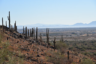
The industrial-wild flavor of Casa Grande Mtn Park


To the southeast, look for the profiles of Picacho Peak and the Picacho Mountains backed by the distant Tortolita and Santa Catalina Mountains near Tucson.  Several unsigned paths and roads cross the trail over the first mile.  Just stay on the well-worn main route. At B-2 GPS marker, the trail splits.  Both legs are about the same length but the “blue” choice offers a moderate hike while the “green” side remains easy.

Picacho Peak (R) stands over an agricultural valley

Both reconnect then split again before converging at the A-5 GPS marker at the 1.48-mile point where hikers can double back or connect with the Ridge Trail for a more challenging return route. 
Trail whistles are the soundtrack of the hike

Spine trail splits into easy and moderate legs

Either way, this easy-access mountain destination at the intersection of workloads and wilds delivers a rewarding day of hiking. Train horns and all.
Giant saguaros are a common site in the park

LENGTH: 3.29 miles roundtrip as described here

RATING: easy-moderate

ELEVATION: 1,505 – 1,626 feet

GETTING THERE:

Arica Trailhead, 2090 E. Arica Road.

From Interstate 10 in Casa Grande, take the Sunland Gin Road exit 200.  Turn right at the bottom of the offramp and continue a short distance south to Arica Road on the right just past the Love’s Truck Stop.  Follow Arica Road 1.6 miles to the trailhead. Roads are 100% paved.

There’s a porta potty at the trailhead but no other facilities.

INFO & MAPS:

City of Casa Grande

https://casagrandeaz.gov/cg-mountain-trails-project/


Monday, December 6, 2021

Juniper Tank

JUNIPER TANK

Juniper Tank is a wildlife haven in Coconino NF

Forest Road 525 serves as an artery of access to multiple recreational destinations. 

Bear Mountain viewed from FR 525 west of Sedona

Located in a

pocket of airy desert scrub between the craggy red rock faces of the Secret Mountain Wilderness and juniper-studded grasslands of Coconino National Forest west of Sedona, the road leads to several OHV routes, the Palatki and Honanki heritage sites and the rugged and remote Loy Canyon hiking trail. 

A wire gate marks the entrance to Juniper Tank

A steady stream of vehicles, usually laden with camping equipment, bikes or trailers, kick up dust along the dirt-and-gravel track. 
A fringe of mesquite provides cover for wildlife viewing

While the obvious recreational draws account for the majority of traffic, a tiny wildlife oasis just steps from the rev-and-roar of 4x4s holds a surprising flip side to the road’s offerings.  The hike to Juniper Tank can be short or long, depending on where you begin.  I parked in a dirt lot 1.3-mile from SR 89A and walked 1.95-miles up FR 525 to the gate for FR 9574 at the Diamondback Gulch OHV trailhead which marks the start of the walk to the tank.  Even though the road walk shares space with motorized traffic, the views more than make up for the dust.  To the west, Mingus and Woodchute mountains stand out over acres of golden rangeland dotted with cacti, junipers and yucca. 
Windmill Mountain soars above Juniper Tank

Directly ahead, the lopsided mound of 4,651-foot Windmill Mountain looms over water-scoured drainages while the iconic forms of Loy Butte, Capitol Butte and Bear Mountain anchor a wall of russet-and-buff-colored wilderness peaks.  From the gate, it’s a one-mile roundtrip walk to and around the tank. Follow the closed road, which is open to foot and equestrian use, as it descends over jostled red earth that traces the cut of a drainage.  
Critters leave their signatures at Juniper Tank

A few yards in, the road splits. Stay right and keep walking as the road gradually degrades into a narrow trail and overgrown footpath. 
Silverleaf nightshade berries grow around Juniper Tank

Windmill Mountain on the Juniper Tank hike

Flocks of birds and scurrying critters are the only clues that a wildlife water source is nearby.  Look for the opening in a post-and-wire fence just ahead, pass through and follow the paths-of-use to a berm that contains Juniper Tank.  
The road to the tank narrows to weedy footpaths

First glimpses of the glassy pond reflecting clouds, mountains and the movements of winged inhabitants are breathtaking. 
Many species of birds flock to Juniper Tank

Trailhead is near Diamondback Gulch OHV area

Situated in a depression surrounded by desert vistas and seep willows, the shallow, reedy waterhole is a haven for desert creatures.  Prints along the muddy margins document visits from bobcats, deer, javelinas, skunks, racoons and dozens of bird species. 
FR 9574 is open to non-motorized use

A fringe of mesquite trees provide places to hide and observe. 
Clouds and trees reflect in Juniper Tank

Patient hikers might spy sparrows, wrens, warblers, shorebirds and maybe even eagles. 
View of Mingus Mountain from FR 525

Dodging catclaw, cacti and a jump over a drainage outlet, the short walk around the tank’s perimeter unpacks rustlings of life, scat, feathers and impressions of a robust community that thrives in a who-knew refuge curiously close to road ruckus.
Forest Road 525 leads to Loy Butte

 
Bear Mountain seen from Juniper Tank

When done taking in the secluded gem, double back and enjoy the sights in reverse.
High-desert scrub dominates the scene along FR 525

LENGTH: 5.2 miles as described here

RATING: easy

ELEVATION: 3,962 – 4,291 feet

GETTING THERE:

From the State Route 179/89A traffic circle in Sedona, go 9.7 miles west (left) on SR 89A to Forest Road 525 (Loy Butte Road) on the right.  Continue 3.25 miles on FR 525 to the trailhead at the Diamondback Gulch OHV kiosk.  Hike begins at the gate signed for FR 9574.  NOTE: to extend the hike, park in any of the dirt pullouts or dispersed campsites along FR 525.  This description begins from a parking area 1.3 miles from SR 89A.

FR 525 is maintained dirt and gravel suitable for all vehicles up to the trailhead.


Monday, November 29, 2021

Camino Campana

CAMINO CAMPANA

Camino Campana was dedicated on 10-31-21


Desert pop quiz!  What’s metarhyolite?  How many entrance holes are in a packrat midden? What’s the function of a “nurse plant”?  In what ways do dead saguaros benefit the environment?  Stumped? 

Chris & Dawn Vandell of Ftn Hills walk their dog Vinny

To learn the answers to these questions and much more, take a stroll on the Camino Campana in the Scottsdale McDowell Sonoran Preserve. 
Pablo Moyano of Mesa inspects a geology display

The trail is named for Kathryn “Sam” Campana who has been an advocate for environmental issues, a Scottsdale elected official, non-profit executive, arts advocate, volunteer and mover-and shaker in the planning and development of the preserve.  The 0.74-mile, barrier-free interpretive path which loops through breezy desert at the base of Fraesfield Mountain is outfitted with beautifully-illustrated signs and interactive displays. 
Leashed dogs are welcome on preserve trails

Each of the 11 educational stops along the route explores a different aspect of the surrounding landscape.  Hikers will learn about geology, bird nests, human history, archeology, wildlife and plants.  The wide, stroller and wheel chair accessible trail is perfect for those with mobility challenges or wrangling kids while restrooms and shade at the trailhead round out the family-friendly amenities.  
An ersatz mountain lion stalks its prey

The trail also has a surprise lurking in the mesquite that gives hikers a momentary fright. 
A harmless coachwhip snake slithers for cover.

Who lives here? There's a sign for that.

Look for a metal silhouette of a mountain lion stalking its prey that looks startling real from a distance. 
Seven-month-old Vinny strikes a pose.

Dedicated on October 31, 2021, the meandering loop unwinds its instructive gems with intuitive panache.  A kiosk about washes leans over a wash, a sign directing visitors to look to the sky sits below a hillside popular with raptors and a strategically-placed view station with a postcard-style frame and adjacent selfie stand presents an irresistible opportunity to document the trip. 
The Camino Campana is wide and barrier-free

LENGTH: 0.74 mile loop

RATING: easy, barrier-free

ELEVATION: 2,540 ft

GETTING THERE:

Fraesfield trailhead:

13400 . Rio Verde Dr., Scottsdale.

From Loop 101 in Scottsdale, take the Princess/Pima exit 36 and go 6.5 miles north on Pima to Dynamite Blvd./Rio Verde Dr.  Turn right and go 5.6 miles to the trailhead on the left.  There are restrooms but no water at the trailhead.

PRESERVE HOURS: Sunrise to sunset daily. Check website for exact times.

INFO:

https://www.scottsdaleaz.gov/preserve


Monday, November 22, 2021

Pass Mountain Trail

PASS MOUNTAIN TRAIL

Goldfield Mtns & Four Peaks seen from Pass Mtn

In terms of sensory overload, the Pass Mountain Trail works sort of like an old-style 5-disk CD changer to deliver a cycle of ever-changing delights that once engaged, just keeps on spinning.

Approaching the east flanks of Pass Mountain

The 7.5-mile route that loops through both Usery Mountain Regional Park in Mesa and the urban-wildland interface of Tonto National Forest, packs in the hiking equivalents of mellow slow dance vibes, sultry tangos and pounding hip-hop rhythms. 

Mountain and valley vistas abound on Pass Mtn

An edgy section of the Pass Mtn Trail

Accessible by way of convenient trailheads in the park, the rocky single track blends low desert strolls, a carousel of vistas and just enough raw mountain exposure to serve up one of the most diverse, close-to-town hikes in the Metro Phoenix area.
A close-to-town hike with wilderness vistas
  Park rangers recommend taking on the loop from either the Wind Cave or Horse Staging trailhead in a clockwise rotation (begin by going left) for a longer but milder ascent to the hike’s scenic saddle.  For those who just want to get to the high point vista and then double back, that’s the ticket, however full-loop hikers should consider a counterclockwise (go right) approach.
Tangles of Sonoran Desert vegetation on Pass Mtn

It’s harder that way, but it gets the difficult climbing over quicker and eliminates the chore of negotiating a steep, slippery down climb on tired legs.

Pass Mtn viewed from the park side of the trail

  Heading right from the Wind Cave trailhead, the trail almost immediately exits the park boundary and enters Tonto National Forest. 
Lichens color the cliffs of Pass Mountain

The first relatively flat half-mile runs through classic desert vegetation and ruffled washes in the shadow of the pyramid-shaped Cat Peaks.  
A slickrock passage leads to a scenic saddle

Over the next mile-and-a-half, views of the Superstition Mountains rising above the town of Apache Junction command the eastern horizon as the trail makes a northward bend and a barely noticeable ascent toward on the mountain’s east face. 
Approaching the U-shaped saddle on Pass Mtn

Residual glimpses of rooftops and roads are soon swallowed up in the folds and drainage cuts of the mountain’s wild side. 
Stunning views from the Pass Mtn saddle


A valley flush with saguaros sits below the destination—a U-shaped pass visible on the north ridgeline.  The climb to get there isn’t too difficult until about a half-mile from the top where the route hangs on precipitous edges and a slickrock ledge for an appetizer of adrenaline before the trail emerges on the prize. 
The trail heads north from the saddle

Bam!  The wind-in-your-face jolt of stepping onto the 2,593-foot saddle is a jaw-dropping experience.  With a single bend in the trail, the vistas make an explosive transition from saguaros and suburbs to layers of mountains and river valleys.
A saguaro-cluttered valley precedes a steep climb

Mesquite and Palo verde trees shade the lower trail

 
In the foreground, the blocky, colorfully-layered Goldfield Mountains rise above a scoured divide.  Behind them, are the iconic Four Peaks and rows of wilderness peaks stand over the Salt River Valley.  
Another view of the saddle approach

View of the saddle on the right ridgeline

Save for some minor drainage crosses and exposure the remainder of the trail is just a moderate trudge that hugs the mountain’s eastern flanks, unspooling views of the Usery Mountains and hazy peeks at the McDowell range near Scottsdale before it swings south and descends to the base of Pass Mountain for the final 2-mile walk back to the trailhead.
Superstition Mountain views


LENGTH: 7.5-mile loop

RATING: difficult

ELEVATION: 1,866 – 2,598 feet

GETTING THERE:

Usery Mountain Regional Park,

3939 N. Usery Pass Rd., Mesa.

From U.S. 60 in Mesa, take the Ellsworth Road exit 191. Go 6.7 miles north on Ellsworth (which will turn into Usery Pass Road) to the Usery Mountain Regional Park entrance on the right.  The tail may be accessed from the Wind Cave and Horse Staging Area trailheads.  There are restrooms at both trailheads.

FEE: There’s a $7 daily fee per vehicle payable at the park entrance. 

INFO: https://www.maricopacountyparks.net/usery-mountain-regional-park-um/