JUNIPER
TANKJuniper Tank is a wildlife haven in Coconino NF
Forest
Road 525 serves as an artery of access to multiple recreational
destinations. Bear Mountain viewed from FR 525 west of Sedona
Located in a
pocket of
airy desert scrub between the craggy red rock faces of the Secret Mountain Wilderness
and juniper-studded grasslands of Coconino National Forest west of Sedona, the
road leads to several OHV routes, the Palatki and Honanki heritage sites and
the rugged and remote Loy Canyon hiking trail.
A wire gate marks the entrance to Juniper Tank
A steady stream of vehicles, usually laden with camping equipment, bikes
or trailers, kick up dust along the dirt-and-gravel track. A fringe of mesquite provides cover for wildlife viewing
While the obvious recreational draws account
for the majority of traffic, a tiny wildlife oasis just steps from the rev-and-roar
of 4x4s holds a surprising flip side to the road’s offerings. The hike to Juniper Tank can be short or
long, depending on where you begin. I parked
in a dirt lot 1.3-mile from SR 89A and walked 1.95-miles up FR 525 to the gate
for FR 9574 at the Diamondback Gulch OHV trailhead which marks the start of the
walk to the tank. Even though the road
walk shares space with motorized traffic, the views more than make up for the
dust. To the west, Mingus and Woodchute mountains
stand out over acres of golden rangeland dotted with cacti, junipers and
yucca. Windmill Mountain soars above Juniper Tank
Directly ahead, the lopsided
mound of 4,651-foot Windmill Mountain looms over water-scoured drainages while
the iconic forms of Loy Butte, Capitol Butte and Bear Mountain anchor a wall of
russet-and-buff-colored wilderness peaks. From the gate, it’s a one-mile roundtrip walk
to and around the tank. Follow the closed road, which is open to foot and equestrian
use, as it descends over jostled red earth that traces the cut of a drainage. Critters leave their signatures at Juniper Tank
A few yards in, the road splits. Stay right
and keep walking as the road gradually degrades into a narrow trail and overgrown
footpath. Silverleaf nightshade berries grow around Juniper Tank Windmill Mountain on the Juniper Tank hike
Flocks of birds and scurrying
critters are the only clues that a wildlife water source is nearby. Look for the opening in a post-and-wire fence
just ahead, pass through and follow the paths-of-use to a berm that contains
Juniper Tank. The road to the tank narrows to weedy footpaths
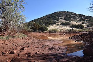
First glimpses of the glassy
pond reflecting clouds, mountains and the movements of winged inhabitants are
breathtaking. Many species of birds flock to Juniper Tank
Trailhead is near Diamondback Gulch OHV area
Situated in a depression
surrounded by desert vistas and seep willows, the shallow, reedy waterhole is a
haven for desert creatures. Prints along
the muddy margins document visits from bobcats, deer, javelinas, skunks,
racoons and dozens of bird species. FR 9574 is open to non-motorized use
A
fringe of mesquite trees provide places to hide and observe. Clouds and trees reflect in Juniper Tank
Patient hikers might spy sparrows, wrens, warblers,
shorebirds and maybe even eagles. View of Mingus Mountain from FR 525
Dodging
catclaw, cacti and a jump over a drainage outlet, the short walk around the
tank’s perimeter unpacks rustlings of life, scat, feathers and impressions of a
robust community that thrives in a who-knew refuge curiously close to road ruckus.Forest Road 525 leads to Loy Butte
Bear Mountain seen from Juniper Tank
When done taking in the secluded gem, double
back and enjoy the sights in reverse. High-desert scrub dominates the scene along FR 525
LENGTH: 5.2 miles as described here
RATING: easy
ELEVATION: 3,962 – 4,291 feet
GETTING THERE:
From the State Route 179/89A traffic circle in Sedona, go 9.7 miles west (left) on SR 89A to Forest Road 525 (Loy Butte Road) on the right. Continue 3.25 miles on FR 525 to the trailhead at the Diamondback Gulch OHV kiosk. Hike begins at the gate signed for FR 9574. NOTE: to extend the hike, park in any of the dirt pullouts or dispersed campsites along FR 525. This description begins from a parking area 1.3 miles from SR 89A.
FR 525 is maintained dirt and gravel suitable for all vehicles up to the trailhead.


No comments:
Post a Comment