SPINE TRAIL
Casa Grande Mountain Park.
 |
| Desert vegetation in Casa Grande Mtn Park |
The Casa Grande Mountains form an abrupt divide in a landscape commandeered by busy transportation corridors, cotton fields, irrigation canals and desert basins dotted with neon signs denoting truck stops, road side motels, feed stores and RV parks.
 |
| Arica trailhead in Casa Grande Mtn Park |
The north-south running range is situated where Interstate 8 swerves west off I-10 and railroad tracks funnel snake-like streams of freight cars through dusty flatlands.
 |
| The Picacho Mountains seen from the park |
Awash in the sounds of train horns and the rumble of big rigs, Casa Grande Mountain Park, with its over 17 miles of non-motorized recreational trails, presents a tetchy truce with the roar of commerce grinding below its slopes.
 |
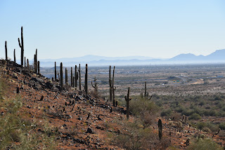
| Saguaros clutter the slopes of Casa Grande Mtn |
The trails trace the east flanks of the mountain in long, loopy segments that alternately climb to high-point vistas and duck through drainages and rocky bends that momentarily muffle the cacophony of cars and cargo carriers.
 |
| A hawk takes flight with a meal in its grasp |
While the soundtrack is a near-constant companion, the trails seem to blend well with the rural-railway theme—apart from but part of the area’s ambiance. After a few miles of hiking, the ambient din reinvents itself from flaw to supporting character.
 |
| Dawn and dusk are the best times to see hawks |
The noise is a little jarring at first, but the weirdness is quickly absorbed as trail users step into the hilly 1,025-acre Pinal County park where interesting geology, desert vegetation and a robust wildlife community demonstrate how nature and industry can share space.
 |
| Trail post marks theturnaround point for this hike |
Arranged in interconnected coils, the trail system is designed for easy customization.
 |
| Neon signs glow below Casa Grande Mtn |
The downloadable park map and trail posts are color-coded: blue for easy, green for moderate and black for difficult. Two long anchor routes, the Spine and Ridge trails, serve as main arteries from which several connecting paths diverge.
 |
| Palo verde trees shade the trail |
For an easy- moderate-rated taste of the park, begin at the Arica trailhead. From the kiosk, follow the access path and veer right onto the Spine trail, which stays low on the mountain’s eastern front.
 |
| Extend the hike on any of the park's17 miles of trails |
At the first trail post, head right and continue north among giant saguaros and boulder-jumbled washes. The open country makes for prime hunting grounds for hawks that wait atop saguaros ready to make a meal of any reptile, small mammal or bird that shows itself.
 |
| The industrial-wild flavor of Casa Grande Mtn Park |
To the southeast, look for the profiles of Picacho Peak and the Picacho Mountains backed by the distant Tortolita and Santa Catalina Mountains near Tucson. Several unsigned paths and roads cross the trail over the first mile. Just stay on the well-worn main route. At B-2 GPS marker, the trail splits. Both legs are about the same length but the “blue” choice offers a moderate hike while the “green” side remains easy.
 |
| Picacho Peak (R) stands over an agricultural valley |
Both reconnect then split again before converging at the A-5 GPS marker at the 1.48-mile point where hikers can double back or connect with the Ridge Trail for a more challenging return route.
 |
| Trail whistles are the soundtrack of the hike |
 |
| Spine trail splits into easy and moderate legs |
Either way, this easy-access mountain destination at the intersection of workloads and wilds delivers a rewarding day of hiking. Train horns and all.
 |
| Giant saguaros are a common site in the park |
LENGTH: 3.29 miles roundtrip as described here
RATING: easy-moderate
ELEVATION: 1,505 – 1,626 feet
GETTING THERE:
Arica Trailhead, 2090 E. Arica Road.
From Interstate 10 in Casa Grande, take the Sunland Gin Road exit 200. Turn right at the bottom of the offramp and continue a short distance south to Arica Road on the right just past the Love’s Truck Stop. Follow Arica Road 1.6 miles to the trailhead. Roads are 100% paved.
There’s a porta potty at the trailhead but no other facilities.
INFO & MAPS:
City of Casa Grande
https://casagrandeaz.gov/cg-mountain-trails-project/


No comments:
Post a Comment