WILLOW
CROSSING
The limestone arch in Willow Valley
Tucked
into a sliver of space in the canyon-addled watershed of West Clear Creek, Willow
Valley is a calm oasis of green in an water-carved landscape. Within the shallow canyon, a sketchy trail
known as Willow Crossing descends from an airy plateau littered with toppled
trees from past wildfires, wildflower meadows and a smattering of tall pines into
a narrow canyon with a totally different character. 
Inside the riparian zone of Willow Valley
Bound by chalky limestone walls chiseled into
layer-cake-like formations, the ecozone inside the mini, Mogollon Rim gorge
transforms from a sunny, lightly-wooded mesa into a jungle of greenery. 
The rim above Willow Valley in Coconino National Forest
This tiny Eden isn’t easy to find or follow,
but careful explorers are rewarded with many surprises. A series of rough dirt
back roads near Clints Well in Coconino National Forest northeast of West Clear
Creek Wilderness, lead to a barely-there trailhead. To
pick up the historic route, follow the old barbed wire fence to a gate near the
edge of the canyon. Pass the gate (close it behind you) and pick up the obvious
path leading downhill. 
Riparian vegetation in Willow Valley
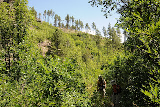
As the short, rocky trail descends among hairy stands of
common mullein that can sprout corn-like shoots to over 6 feet high, riparian
vegetation closes in on the trail.Common mullein grows on the canyon rim

Willow Valley is in the watershed of West Clear Creek
Gamble oaks, boxelder, New Mexico locust and a tangle of
the eponymous willow trees clutter the slopes. Where the trail bottoms out at a
drainage, look for water-loving wildflowers and shrubs like larkspur, wild
roses and red-osier dogwood. Larkspur colors the trail in summer.
Like all “crossing”
trails on the Rim, this one hops the drainage and heads up to the opposite lip
of the canyon. In between the rims, the hike’s signature attraction stands
nearly obscured by tree cover and wild grape vines woven among thickets and boulders.
Red-osier dogwood grows in the drainage area
A delicate natural arch carved from the canyon’s sedimentary rock walls forms a fragile
bridge over a fold in the disintegrating wall revealing a glimpse of sky and
Ponderosa pines 400 feet above.
LENGTH: 2-3 miles round trip
RATING: moderate
ELEVATION: 6,400 – 6,800 feet
GETTING THERE:
From Payson, go north on State Route 87 to Lake Mary Road (County Road 3) turn left and go north on CR3 to Forest Road 81 at milepost 297.7. Turn left and continue 3.1 miles to Forest Road 81E. Set your odometer, and go left on FR 81E 1.14 miles to Forest Road 9366M—an easy-to-miss, unmarked dirt road on the left. Go 0.5 miles on FR 9366M to a cattle guard and gate. The trailhead is just past the gate on the left near the generic “trail” sign and rock cairns. A high clearance vehicle is recommended on the forest roads.
INFO:
Coconino National Forest
https://www.fs.usda.gov/recarea/coconino/recarea/?recid=55052


No comments:
Post a Comment