RED BIRD-GOOSENECK LOOP
 |
| A boulder passage on the Gooseneck Trail |
By trail, it’s only 7 miles from the Fraesfield trailhead to the Tom’s Thumb trailhead in Scottsdale’s McDowell Sonoran Preserve Central Region.
 |
| Fraesfield trailhead seen from Gooseneck trail |
Three miles, as the crow flies. The trail miles wind within a narrow strip of Sonoran Desert that sits between the preserve’s north and south regions.
 |
| Snow capped Mazatzal Mountains |
Serving as a non-motorized travel corridor and buffer zone between suburbs and wilds, the tiny parcel abuts private property and McDowell Mountain Regional Park with just enough width for a seamless, airy transition.
 |
| Granite formation on the Redbird Trail |
While the Central Region of the preserve sees less action than its compatriots, the maze of routes it holds offer less crowded treks with some of the best mountain vistas in the northeast Valley.
 |
| Desert rockpea bloom on the Redbird Trail |
The 6.7-mile Gooseneck Trail, which is also part of the 315-mile Valley-circling Maricopa Trail, is the region’s main artery and can be used as the primary path in building customized hikes.
 |
| Creosote forest on Gooseneck Trail |
From the Fraesfield trailhead, the Gooseneck single track trail heads south in a lazy-S format--much like its moniker suggests.
 |
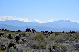
| Four Peaks seen from Service Road #2 |
Several short trails, connectors and service roads spin off the curvy, weel-signed conduit for use in creating loops, through hikes or out-and-back treks. One day hike to try uses the Gooseneck, Redbird and Service Road #2 trails for a tour that includes amazing geology, lush desert vegetation and eye-popping views all around.
 |
| Desert hyacynth (Blue Dicks) on Redbird trail |
To get the most out of this off-the-beaten hike, spend a few moments at the Fraesfield trailhead mountain-identifying display. The artistic iron display shows the names and elevations of surrounding peaks visible from the trails.
 |
| Mushroom rocks sprout in the Central Region |
Heading south on Gooseneck, the route winds among saguaros and cholla cactus, crossing Rio Verde Drive at the 0.8-mile point. Across the road, the vegetation morphs from cactus-centric to a sea of creosote and brittlebush. The mostly level trail gains elevation gradually, opening magnificent mountain views. The prominent profiles of Mazatzal Peak, Mount Peeley, Saddle Mountain and Mount Ord stand out to the northeast.
 |
| Tom's Thumb seen from Service Road #2 |
To the southeast, the hazy silhouettes of the Superstition Mountains dominated by Weaver’s Needle and the Flatiron hover over the Salt River basin and Tonto National Forest.
 |
| Wolfberry shrub in a desert wash |
The preserve’s famous “mushroom rocks”—granite formations that have been sculpted into bizarre shapes over millions of years by the forces of nature, make an appearance here as well. At the 1.6-mile point, the route heads west on the Redbird trail. This 1.1-mile segment passes through several glinting stony passages at the hike’s highest elevation with excellent views of the iconic Tom’s Thumb pinnacle perched atop the McDowell Mountains. The route then swings east on Service Road #2. The unsexy name belies a beautiful walk through a wash-riddled landscape where water-loving wildflowers, mesquite and hackberry shrubs thrive in sandy soils. The road also unveils best looks at the cloud-piercing mounds of the Four Peaks Wilderness Area.
 |
| Superstition Mountains seen from Redbird Trail |
 |
| Brown's Mtn (L horizon) seen from Service Rd |
Where the road meets up with Gooseneck, the route swings back north for the return leg of the hike. Open to the sky and drenched in the resinous scent of creosote, the homeward trek keeps on delivering goodies. Look for peeks at the flat-topped form of Brown’s Mountain in the preserve’s north region backed by the sprawling mesas and peaks of the Cave Creek Mountains.
 |
| Fiddleneck bloom on the Redbird Trail |
Once explored, it becomes clear that the preserve’s Central Region is much more than just a bland thoroughfare between two supernovas. Like an Oreo cookie, there’s good stuff in the middle.
 |
| Kiosk at Fraesfield trailhead |
LENGTH: 6.6 miles roundtrip
RATING: easy
ELEVATION: 2,494 – 2,693 feet
GETTING THERE:
Fraesfield trailhead:
13400 E. Rio Verde Dr. Scottsdale
There are no fees. There are restrooms but no drinking water at the trailhead.
HOURS: sunrise to sunset daily
INFO & MAPS:
Scottsdale’s McDowell Sonoran Preserve


No comments:
Post a Comment