ARIZONA CYPRESS TRAIL
 |
| Scaled AZ cypress cones |
Hitting a never hiked trail for the first time is always a thrill. New views, unfamiliar terrain, and the fun of navigating an untested route are big draws for those who crave fresh outdoor experiences. And then there are the familiar “go-to” routes.
 |
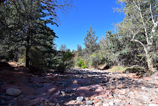
| Trail crosses Dry Creek several times |
Like polar opposites, one serves up a rush of adventure while the other is like the comfort food of hiking. While untried adventures will always woo us, many of us hikers spend more time in the comfort zone.
 |
| Blackfoot daisies bloom March - December |
Whether hiked to train for a big trek or for long-term conditioning, comfort trails are those that are a combination of convenience, familiarity, and reliable experience.
 |
| Doe Mtn. (L) and Bear Mtn. from AZ Cypress trail |
Most hikers have a favorite—the one they return to time and again, with or without a salient explanation.
 |
| Upper Dry Creek Area Trails |
The Arizona Cypress Trail in Sedona checks all the boxes for a no hassle go-to trail.
The classic Sedona trail can be access by way of a large parking area with emptiness probably perpetrated by the adjacent target shooting area. The repellant trailhead noise is a tolerant hiker’s gain leading to light traffic and easy parking—a rare treat in Sedona.
 |
| Featherplume bloom March - June |
The route immediately ducks into the forest where canyon walls absorb the intermittent pop-pop of gunfire.
 |
| AZ cypress trees along the trail |
This trail’s sticking power is magical elixir of solitude (unusual for a trail located down the road from Devils Bridge) and sweet scenery wrapped around a desert waterway in the Upper Dry Creek Area Trails Coconino National Forest.
 |
| Tufted Evening Primrose bloom Apr-Sep |
It’s an easy 3.8-mile out-and-back hike on AZ Cypress. But there are plenty of ways to extend the trek. The trail links up with a looped maze of eight routes that use the old standard Girdner Trail as a backbone that runs south to connect with the Western Gateway trails.
 |
| False toadflax blooms April - August |
Several crossings of Dry Creek, traipses through wildflower meadows, manzanita thickets, and highpoint vistas showcasing familiar landmarks like Cockscomb, Capitol Butte, Doe Mountain, and Bear Mountain keep things interesting but the eponymous cypress trees alone are enough to keep this trail on auto rewind.
 |
| View of Cockscomb formation from AZ Cypress |
Cupressus arizonica can grow up to 90 feet tall, but most are around 40-60 feet and it’s the only cypress native to the Southwest. The deep emerald conical-shaped trees thrive at elevations between 3,000- 6,000 feet, with a preference to drop roots along intermittent streams. The attractive evergreen has a distinctive shedding shaggy bark and scaly blue-green leaves that emit a pleasant piney fragrance. The tree’s most distinctive feature is the woody, walnut-sized scaled cones that look as if they might encapsulate some alien lifeform.
 |
| Ash trees in Dry Creek |
Even when spent, the cones can cling to branches in eerie black clumps. It’s not just the seeds that are tenacious--scientists studying pollen trapped in ancient packrat middens say the species has been around since prehistoric times, at least since the icy Pleistocene Epoch---a testament to its namesake trail’s steadfastness.
LENGTH: 3.8 miles round trip
RATING: moderate
ELEVATION: 4,309 – 4,416 feet
GETTING THERE:
Arizona Cypress Trailhead: From the State Route 179/89A traffic circle in Uptown Sedona, go 3.2 miles west (toward Cottonwood) on SR 89A to Dry Creek Road. Follow Dry Creek Road 2.7 miles to the turnoff for Forest Road 9589 (not signed) on the left. This easy-to-miss turnoff is located a few yards south of the Boynton Pass Road/Long Canyon Road “T” intersection.Continue 0.2-mile on FR 9589 (good dirt with a few potholes) to the end and the parking circle at the AZ Cypress trailhead. NOTE: there is a target shooting pit near the trailhead, which might frighten dogs and horses. There are no fees or facilities at this trailhead.
INFO & MAPS
https://www.fs.usda.gov/recarea/coconino/recarea/?recid=71954&actid=50


No comments:
Post a Comment