Find A Trail. Start Your Search Here:

Monday, April 29, 2024

Granite Mountain Hot Shots Juniper Hike

GRANITE MOUNTAIN HOT SHOTS  JUNIPER HIKE

Granite Mountain Hot Shots juniper

On the Department of Forestry and Fire Management Magnificent Trees Program and the Arizona Magnificent Tree Registry, it’s listed simply as “Tree 4126.”  But the enormous Alligator Juniper has a history that transcends its drab catalog callout.

Riparian trees near Division Well on FR9162U

  
Located in

Prescott National Forest west of Granite Mountain Wilderness, the gnarled old tree is best known as the Granite Mountain Hot Shots Tree.

Mountain vista on Upper Pasture Trail

 It’s named in honor of the 20 wildland firefighters who saved it during the June 2013 Doce Fire that burned about 7,000 acres 10 miles northwest of downtown Prescott.  Tragically, 19 members of the team perished in the Yarnell Hill Fire on June 30, 2013.
Gate on FR 9162U

The iconic Yavapai County Alligator Juniper (Juniperus deppeana) stands 52 feet high and has a circumference of 324 inches.  It’s crown spreads to an average of 70 feet. 

The Hot Shots Juniper is over 50 feet tall

There are over 200 Arizona trees on the Arizona Magnificent Tree Registry that includes myriad species sorted into three categories.  

Signs of the 2013 Doce Fire on White Rock Springs

Champion Trees are those that are the largest in the state or nation.  Heritage Trees hold cultural significance such as for a commemoration, and Witness Trees are those that have been growing in the same spot since before Arizona Statehood (1912).
Agaves on the Upper Pasture Trail

The Hot Shots Juniper is recognized as both a state and national Champion Tree.  While its exact age is impossible to pinpoint, the tree is easily over 1,000 years old--some sources estimate it may be more than 2,500 years old--which means it is also an undisputed Arizona Witness Tree.

Upper Pasture Trail junction

Hikers interested in botany, state history or making a pilgrimage to remember the Hot Shots can visit the tree by using roads and trails in Prescott National Forest.

Spring on White Rock Springs Trail

There are several ways to make the trek, but the shortest route begins at the Contreras Trailhead off Iron Springs Road. From the north corner of the parking area, the hike follows Forest Road 9162U for 0.8-mile. The rough, rocky two-track descends to the site of Division Well, crosses a leafy drainage and heads steeply uphill to a gate that marks the beginning of Upper Pasture Trail No.38. 

White Rock Springs Trail junction

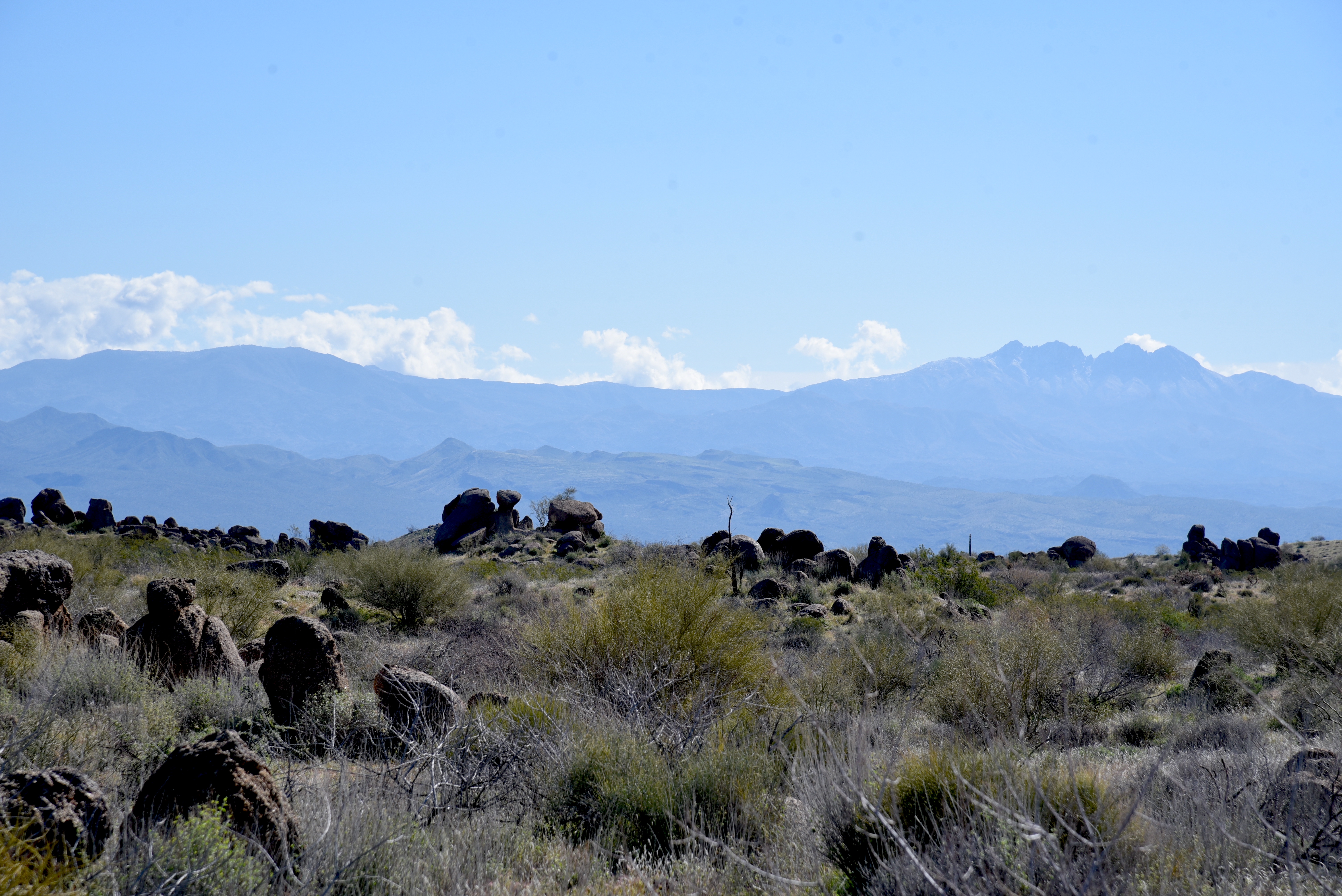
Trail 38 is a repurposed horse road constructed in the 1800s. The wide, gently undulating track is largely unshaded, passing through chaparral punctuated with agaves, cacti and spots of pinyon pine and junipers.  Excellent views Big Chino Valley and the distant Santa Maria Mountains dominate the northern horizon, but it’s the hulking presence of Granite Mountain and Little Granite Mountain to the east that really commands attention.  Rising to 7,626 and 7,089 feet respectively, the massifs appear as enormous boulder piles with weather-worn stones spilling down their flanks. 
Boulders line White Rock Springs Trail

On the high ridges, chockstones balance in tenuous poses pierced by scrub oak and manzanita.  At the 1.8-mile point, the route heads north (left) at the White Rock Springs Trail No. 39 junction.  
Upper Pasture Trail is an old horse road

Now a dirt singletrack, the trail passes remnants of the 2013 Doce Fire. Eleven years on, charred snags and burnt brush are ceding space to new growth.  A lush spring area at the end of a rough-cut drainage sits at the base of a granite wall, surrounded by willows, cottonwoods, buffalo-bur and wildflowers.  A half-mile in on Trail 39, the route crosses a major sandy drainage.  A few yards past the waterway, chunks of white quartz placed in the sand point the way to an unsigned trail that leads to the Hot Shot Juniper.  

The short spur path ends at the tree and a memorial erected under its massive canopy.  

Memorial at the Hot Shots Juniper

Words,  photos, and statistics are inadequate tools for describing the twisted giant.  Hints of its unknowable origins and secrets of its resilience are best expressed in the resinous, ash-tinged mountain breezes that rattle its branches. 
AZ Black rattlesnake on Upper Pasture Trail

Hike starts at the Contreras Trailhead

LENGTH: 4.8 miles round trip (out-and-back hike)

RATING: moderate

ELEVATION: 5,294 – 5,548 feet

GETTING THERE:

Contreras Trailhead:

From historic downtown Prescott, go north on Montezuma Street (which will turn into Whipple Street and then Iron Springs Road) and continue 10 miles to Contreras Road (County Road 122) on the right.  Follow CR122 for 0.7-mile to the trailhead on the right. Low clearance vehicles park here. Hike begins by walking FR9162U at the north end of the parking lot.  OPTION: High clearance (4x4 recommended) vehicles may be driven 0.8-mile on FR9162U to the Trail 38 trailhead.  Contreras Road is maintained dirt suitable for most vehicles up to the lower trailhead.

INFO:

Prescott National Forest

https://www.fs.usda.gov/recarea/prescott/recreation/recarea/?recid=67471&actid=50

Arizona’s Magnificent Trees

https://dffm.az.gov/arizonas-magnificent-trees

American Forests Champion Tree Registry

https://www.americanforests.org/champion-trees/champion-trees-registry/

Tuesday, April 16, 2024

Arizona Trails Plan Survey 2025


YOUR INPUT IS NEEDED FOR THE FUTURE OF ARIZONA'S TRAIL SYSTEMS.

Arizona State Parks and Trails is currently seeking input 

from thepublic for the 2025 Trails Plan.

The statewide plan aims to enhance trail systems and 

improve access to outdoor recreation in Arizona. 

Your input is valuable in shaping the future of Arizona's 

trail system.


What’s in it for you? 

Not only the opportunity to influence the future of Arizona’s 

trails but also a chance to win awesome Arizona experiences 

and prizes! 

Oracle State Park

Arizona State Parks has awesome incentives you enter a 

drawing for, just by taking the survey. Prizes include 

staycations in scenic Pinetop-Lakeside and Flagstaff, 

a two-night camping trip in a comfortable micro-camper, 

Arizona State Parks annual passes and gift cards, 

and more, thanks to generous partners like the 

Arizona Office of Tourism, Pin Drop Travel Trailers,

and the Southern Arizona Hiking Club! 

Dead Horse Ranch State Park


Trails are an essential part of Arizona's outdoor recreation 

culture,providing access to some of the state's most 

beautiful and unique landscapes. 

More than 4.3 million Arizonans used trails in 2020, and 

we expect that number to continue increasing in the

coming years. 

Trails are not only a source of fun, health, and adventure 

but also an important contributor to the state's economy.

Sonoita Creek State Natural Area


The 2025 Trails Plan is a collaborative effort of our 

organization, Arizona State Parks and Trails, other 

land managers, nonprofits, and the public...that’s YOU! 

We’re seeking input from all trail users, including hikers,

equestrians, mountain bikers, and off-highway 

vehicle riders. 

The survey aims to identify the most pressing trail 

needs and help guide future federal and state 

funding priorities.


The survey covers a wide range of topics related to 

Arizona's trail systems, including:

  • Acquisition of land and new trail development

  • Trail maintenance and improvements

  • Trailhead facilities like restrooms and parking

  • Trail signage and wayfinding

  • Trail safety and education


Your input can help shape the future of Arizona's trail system. 

Whether you're an avid trail user or just getting started, 

your opinion matters.


The survey takes only a few minutes to complete and can be accessed on the Arizona State Parks and Trails website at 

 surveyentrance.com/TrailsPublic7.  

Monday, April 8, 2024

General Crook Trail: Mud Tanks Draw

GENERAL CROOK TRAIL: MUD TANKS DRAW

Tanque Aloma on the General Crook Trail

Most of what remains of the historic General Crook Trail are eroding two tracks, toppled rock cairns, tree blazes, a few telegraph insulators, and roadside monuments. 

Forest Road 142H in Mud Tanks Draw

Originally constructed in the early 1870s, the trail stretched for 200 miles along the edge of the Mogollon Rim in Central Arizona between Fort Verde and Fort Apache.
White chevrons mark the General Crook Trail

The dirt track served as a military and civilian supply route for nearly 50 years before being replaced more efficient travel corridors. 
Evie the Aussie shepherd herds her hikers

In the 1970s, Boy Scouts located and signed bits of the route with chevron-shaped white metal markers and rock cairns, many of which are still in place today to guide hikers through the notoriously sketchy path.  Popular reclaimed passages of the old wagon road trace Rim Road (Forest Road 300) and State Route 260 in Coconino National Forest.
Storm clouds over Mud Tanks Draw

 
The third gate near Tanque Aloma

Roughly 22 miles east of Camp Verde, a portion of the General Crook Trail winds through a hilly, juniper-studded landscape situated between West Clear Creek and Fossil Springs Wilderness areas.  The pastoral backcountry is an alloy of dust and juniper welded into a knobby expanse.
Tanque Aloma on the General Crook Trail

Mountain vistas on General Crook Trail

The resin-scented air augments the raw, wind-sculpted landscape of ruffled hills, grassy rangeland, and shrubs disrupted only by whirlwinds and the occasional rogue coyote or herd of cattle.

First gate where General Crook Trail leaves FR142H

From a non-descript trailhead off State Route 260, the hike to the historic backroad segment begins with a short walk on Forest Road 142H.  The dirt two track twists through Mud Tanks Draw, an area of low ground between ridges where water runoff collects in a chain of pools, rivulets, and mucky ponds.  

Ideal lunch spot near Tanque Aloma

The shallow funnel ruptures the scrubby terrain with payloads of rain and snow melt that flows down from the rim above West Clear Creek eventually dumping into Fossil Creek.  The half-mile walk on FR142H ends at a twig-and-barbed-wire gate off to the right where there’s a 142H sign. 

Buffalo-bur in Tanque Aloma

The first set of General Crook chevrons are tacked to the gate.  This is the General Crook Trail crossroads. For this trip, the route continues straight ahead (not through the gate) following sporadic chevrons nailed to fence posts.
Evie on General Crook Trail, April 6, 2024

Although it’s not signed, this segment of the Crook Trail is also named Forest Road 9243P.  The road makes an easy ascent, dodging junipers, catclaw and a smattering of firs and Ponderosa pines.  
Highest point of the hike on General Crook Trail

A second gate marks the beginning of big mountain vistas that continue to expand as the trail works its way to a third gate at the base of a prominent mesa. 
Trail chevrons on the second gate

Just past the third gate, the muddy waters of Tanque Aloma can been to the right (north) and a short walk uphill to the hike’s high point gives a bird’s eye view of its place in the landscape.  While the road continues west to connect with FR9243N, this trip turns around at the top of the ridge and backtracks to the tank where a spur road leads to the water.  Tanque Aloma’s muddy banks are trampled with footprints of domestic cattle, deer, raccoons, coyotes and myriad little critters and birds.  It’s an important water source for wildlife in the semi-arid terrain.  
Turnaround point on the hike

Ringed with buffalo-bur and coniferous trees, the tank’s reflective qualities are a photographer’s dream.
Apron Tank at the trailhead

  A couple of gigantic junipers along the spur road make for shady lunch spots within view of ravens and hawks riding airwaves above the water.
Trailhead off State Route 260

LENGTH:  5.85 miles out-and-back as described here

RATING: moderate

ELEVATION:  5,819 – 6,137 feet

GETTING THERE: From Interstate 17 in Camp Verde, take the State Route 260 exit 287 and continue 22 miles east (toward Payson) to Forest Road 142H on the left just past milepost 241. Forest Road 142 H is not signed, but there’s a stop sign and cattle guide a few yards in.  For reference, Apron Tank, a shallow pool that sits on both sides of the road, is at FR142H.  There’s parking in a dirt turn out past the cattle guard.  (If you pass under power lines, you’ve gone a mile too far).


Tuesday, March 19, 2024

Redbird-Gooseneck Loop

RED BIRD-GOOSENECK LOOP

A boulder passage on the Gooseneck Trail

By trail, it’s only 7 miles from the Fraesfield trailhead to the Tom’s Thumb trailhead in Scottsdale’s McDowell Sonoran Preserve Central Region.

Fraesfield trailhead seen from Gooseneck trail

 
Three miles, as the crow flies. The trail miles wind within a narrow strip of Sonoran Desert that sits between the preserve’s north and south regions.  
Snow capped Mazatzal Mountains

Serving as a non-motorized travel corridor and buffer zone between suburbs and wilds, the tiny parcel abuts private property and McDowell Mountain Regional Park with just enough width for a seamless, airy transition.  
Granite formation on the Redbird Trail

While the Central Region of the preserve sees less action than its compatriots, the maze of routes it holds offer less crowded treks with some of the best mountain vistas in the northeast Valley. 
Desert rockpea bloom on the Redbird Trail

The 6.7-mile Gooseneck Trail, which is also part of the 315-mile Valley-circling Maricopa Trail, is the region’s main artery and can be used as the primary path in building customized hikes.
Creosote forest on Gooseneck Trail

From the Fraesfield trailhead, the Gooseneck single track trail heads south in a lazy-S format--much like its moniker suggests.  
Four Peaks seen from Service Road #2

Several short trails, connectors and service roads spin off the curvy, weel-signed conduit for use in creating loops, through hikes or out-and-back treks.  One day hike to try uses the Gooseneck, Redbird and Service Road #2 trails for a tour that includes amazing geology, lush desert vegetation and eye-popping views all around.  
Desert hyacynth (Blue Dicks) on Redbird trail

To get the most out of this off-the-beaten hike, spend a few moments at the Fraesfield trailhead mountain-identifying display. The artistic iron display shows the names and elevations of surrounding peaks visible from the trails. 
Mushroom rocks sprout in the Central Region

Heading south on Gooseneck, the route winds among saguaros and cholla cactus, crossing Rio Verde Drive at the 0.8-mile point.  Across the road, the vegetation morphs from cactus-centric to a sea of creosote and brittlebush.  The mostly level trail gains elevation gradually, opening magnificent mountain views.  The prominent profiles of Mazatzal Peak, Mount Peeley, Saddle Mountain and Mount Ord stand out to the northeast.
Tom's Thumb seen from Service Road #2

To the southeast, the hazy silhouettes of the Superstition Mountains dominated by Weaver’s Needle and the Flatiron hover over the Salt River basin and Tonto National Forest. 
Wolfberry shrub in a desert wash

The preserve’s famous “mushroom rocks”—granite formations that have been sculpted into bizarre shapes over millions of years by the forces of nature, make an appearance here as well.  At the 1.6-mile point, the route heads west on the Redbird trail. This 1.1-mile segment passes through several glinting stony passages at the hike’s highest elevation with excellent views of  the iconic Tom’s Thumb pinnacle perched atop the McDowell Mountains.  The route then swings east on Service Road #2.  The unsexy name belies a beautiful walk through a wash-riddled landscape where water-loving wildflowers, mesquite and hackberry shrubs thrive in sandy soils.  The road also unveils best looks at the cloud-piercing mounds of the Four Peaks Wilderness Area. 
Superstition Mountains seen from Redbird Trail

Brown's Mtn (L horizon) seen from Service Rd

Where the road meets up with Gooseneck, the route swings back north for the return leg of the hike.  Open to the sky and drenched in the resinous scent of creosote, the homeward trek keeps on delivering goodies.  Look for peeks at the flat-topped form of Brown’s Mountain in the preserve’s north region backed by the sprawling mesas and peaks of the Cave Creek Mountains.  
Fiddleneck bloom on the Redbird Trail

Once explored, it becomes clear that the preserve’s Central Region is much more than just a bland thoroughfare between two supernovas.  Like an Oreo cookie, there’s good stuff in the middle.
Kiosk at Fraesfield trailhead

LENGTH: 6.6 miles roundtrip

RATING: easy

ELEVATION: 2,494 – 2,693 feet

GETTING THERE:

Fraesfield trailhead:

13400 E. Rio Verde Dr. Scottsdale

There are no fees. There are restrooms but no drinking water at the trailhead.

HOURS: sunrise to sunset daily

INFO & MAPS:

Scottsdale’s McDowell Sonoran Preserve

https://www.scottsdaleaz.gov/preserve