Find A Trail. Start Your Search Here:

Monday, September 16, 2019

WESTERN GATEWAY TRAILS


WESTERN GATEWAY TRAILS
Phase I trails of Western Gateway system opened spring 2019
Way back when, my grandfather kept his “church key” can opener tied to the cooler we’d take along on our fishing trips when I was a snot-nosed kid chasing frogs in Connecticut swamps. The simple strip of metal embossed with the Knickerbocker Beer logo got a workout on these outings—puncturing the lids of pre-flip-top-era beverage cans. When pull-tabs eliminated the need for the handy little tool, our tackle box staple rusted away on its cotton cord. Sometimes, we’d use it to scrape grit off our shoes.
Great Sedona views on the Western Gateway trails
The new trails wind through the Dry Creek drainage area
The distinctive puncture of the church key can opener
Big Sedona views on the Ledge-N-Airy Trail
It’s been more than 50 years since flat-top metal containers that required a church key opener went extinct in the mid 1960s, but in many places in Arizona’s backcountry, piles of these old-style food and beverage cans belie the locations of defunct ranch and mining encampments.  Determining the age and stories behind these sites is best left to professionals who use the distinctive triangular pierce mark of the church key as an index fossil of sorts in the science of can-ology.
View of Mingus Mountain from the Roundabout Trail.
Over the years, various antiquities acts designed to protect archeologically-significant resources on public lands have expanded to include objects as young as 50 years old.  So, although grandpa’s discarded beer cans were once trash, those that survived the elements are now historic artifacts.
Cockscomb formation, center horizon, visible from the trails
A few of these rusty relic sites are visible on the new Western Gateway Trail System in Sedona. Phase 1 of the proposed 30-mile system of fresh-cut, re-aligned and adopted user-created trails was completed earlier this year with the help of  Flagstaff-based American Conservation Experience trail crews and funding from various organizations. The twisted, interconnected trails wind though the hilly high desert that had been part of the old Girdner Ranch in the area around Dry Creek and its drainages.
Capitol Butte seen from the Outer Limits Trail
Centered around the old-standard Girdner Trail that begins north of State Route 89A near Sedona Cultural Park, several routes are finessed, signed and open for exploration. With fun names like Ledge-N-Airy, Outer Limits, Drano, Last Frontier and Roundabout, the singletrack routes offer additional access to a pocket of Coconino National Forest 4 miles west of Uptown Sedona.
Limestone escarpments on Ledge-N-Airy Trail
The new routes spin off from the Girdner and Centennial Trails and may also be accessed from the north at the Fay and Aerie trailheads along Boynton Pass Road.  For a moderate 4.6 mile hike, follow the Girdner Trail to the Outer Limits junction, veer left, pick up the Ledge-N-Airy trail and follow the signs to complete a loop. To see some of the rusty can artifacts, go right at the Outer Limits junction and step out on the Roundabout Trail. Within a half-mile, mounds of the now-protected camp litter are scattered among cacti and scrub oaks, dissolving into the red, dusty soil. As with all heritage sites, please do not disturb or remove anything.
Silverleaf nightshade berries on the Centennial Trail
If you are tempted to “clean up” the place, consider volunteering with an organization like Natural Restorations that will teach you how to differentiate trash from treasures and to remove refuge responsibly without disrupting the ecosystem or sensitive, protected relics. Phases II and III of the Western Gateway project are planned for the near future and are expected to be completed by 2021.
New trails spin off the Girdner & Centennial trails
Historic artifacts on the Roundabout Trail
Prickly pear fruits on the Girdner Trail
LENGTH: 4.6 miles  for the loop described here.
RATING: moderate
ELEVATION: 4440 – 4020 feet
GETTING THERE:
From the State Route 89A/179 traffic circle in Sedona, head 4.2 miles west (left thru the circle) on 89A to Cultural Park Way (traffic signal). Turn right and continue 0.3-mile to the Girdner Trailhead on the right. Trailhead has picnic tables and a map kiosk but no restrooms or water.

INFO & MAP:
COCONINO NATIONAL FOREST
To Volunteer or donate to the Western Gateway project:
SEDONA RED ROCK TRAIL FUND
To volunteer and learn about responsible trail clean-ups statewide:
NATURAL RESTORATIONS:


Saturday, September 7, 2019

SYCAMORE POINT TRAIL

SYCAMORE POINT TRAIL 
Sycamore Point sits above Sycamore Canyon Wilderness 
Roughly 23 miles southeast of Williams, Arizona’s second largest canyon splits the landscape at the juncture of three national forests and two wilderness areas.
High-desert grasslands: one of several eco-zones on the hike
Anchoring a 55,937-acre wilderness, Sycamore Canyon is one of the most remote and primitive gorges in the state. Unlike the Grand Canyon--which claims the number one spot in terms of canyon size-- there are no maintained roads, amenities or reliable water sources within Sycamore Canyon.
A sheer drop off marks the rim of Sycamore Canyon  
Except for a few easy-access, well-travelled trails like Parsons Spring near Cottonwood and the Sycamore Rim Trail south of Williams, exploring in and around this wilderness is not for the casual visitor. Those who venture into its deepest corners best be prepared to navigate miles of tire-eating, confusing back roads to get to trailheads, hike on strenuous paths and carry enough water for the entire trip. Despite the fact that maps show Sycamore Creek meandering through the canyon, water is a rare find.
AZ's second largest canyon is raw and untamed.
Meadows define the mid-section of the hike
The trail is open to hikers, bikes and motorized vehicles
Although a multi-day backpacking trip is the optimum way to experience the multifarious features of this unforgiving backcountry, there’s an easier way to get an overview of the canyon’s scale and diversity. A hike or bike ride on the Sycamore Point Trail #131 culminates at a breathtaking overlook that rivals those along the south rim of the Grand Canyon, but without the crowds and concession stands. This ersatz Ooh Aah Point sits near the intersection of the Prescott, Kaibab and Coconino National Forests, where the Red Rock Secret Mountain and Sycamore Canyon Wilderness areas collide 1000 feet below. There are no guard rails to stall a fall, so use extreme caution when approaching the edge. 
Domestic cattle graze in the forests around the trail 
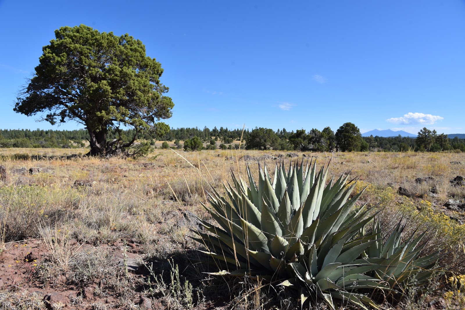
The 10-mile out-and-back trek follows the graveled, rough tail-end of Forest Road 110 that has been designated as multi-use recreational trail.  From the trailhead near JD Dam Lake, the hike begins by heading southeast on a dirt track through shady pine-oak forests. Watch for tiny bike trail signs placed at junctions to stay on track. Near the 2.5-mile point, the environment changes from thick woodlands to open meadows before gradually emerging on a grand plateau with sweeping, high-desert grasslands dotted with pinion pines, agave and Alligator junipers. Soon thereafter, first glimpses of the canyon rim appear on the eastern horizon backed by hazy views of Kendrick Peak and the San Francisco Peaks near Flagstaff. 
Distant San Francisco Peaks seen from Sycamore Point
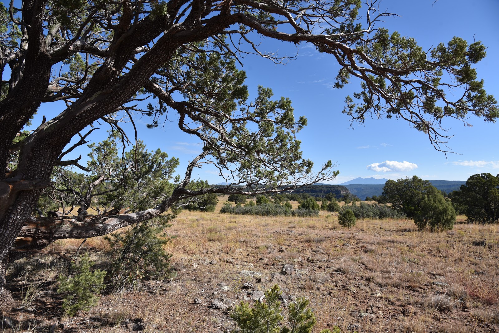
A twisted Alligator juniper survives on an open prairie.
Where the road ends, a wide gravel roundabout makes a swing around the edge of the canyon. Ringed by junipers, shrubs and an understory of yucca and cacti, views of the 20+-mile-long chasm are dominated by russet-stained buttes and chiseled limestone pillars.
Spent agaves frame Bill Williams Mtn on center horizon
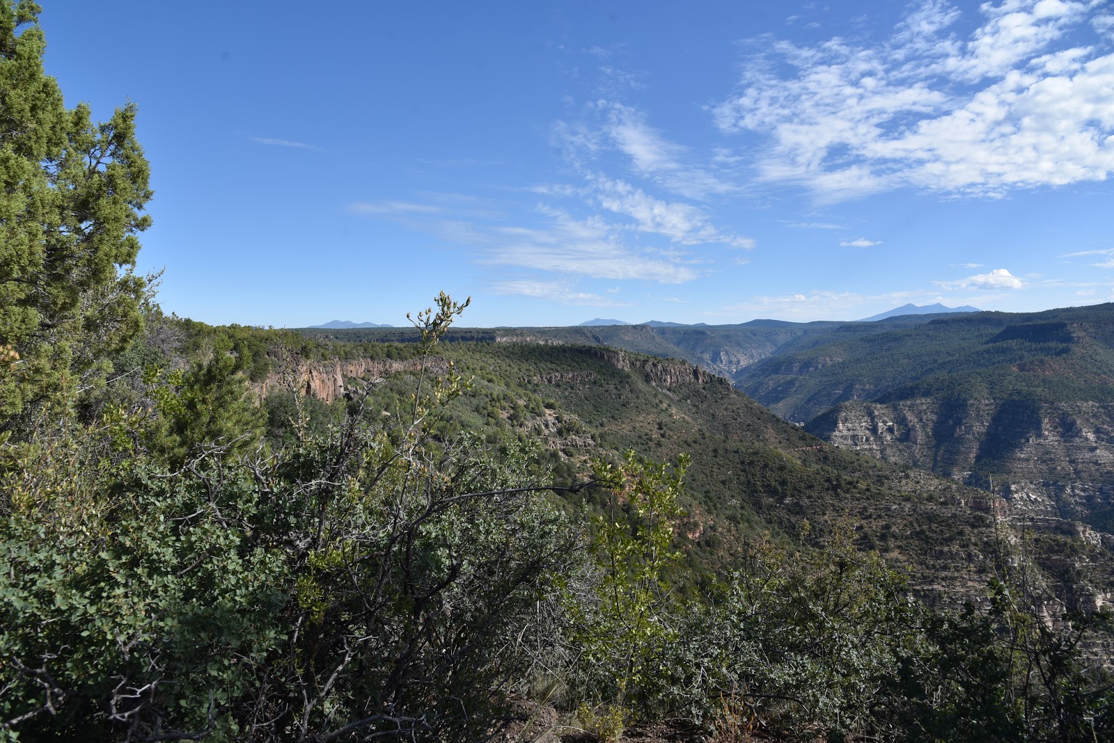
At the brim, a sheer drop off unsettles the nerves while expansive views of the of the wild canyon assault the senses like a rogue tidal wave.  From the precipitous perch, layer upon layer of complex geological features and eco-zones roll out below.
Beautiful rangeland near the canyon's rim.
The point juts out from the edge of the Colorado Plateau to showcase a rare mix of mountain peaks, coniferous woodlands, high deserts and faint strips of riparian trees and shrubs that sink roots into seasonal water pools around Sycamore Creek and feeder streams that drain into the Verde River.
High-desert scrubland near trail's end
Directly under the overlook, the impossible to spot Winter Cabin and Taylor Cabin trails wind among buff-and-vermillion-colored cliffs and water-sculpted ravines while the tree-covered mesas above Sedona’s Oak Creek Canyon bolster the eastern horizon. 
The isolated, exposed and utterly raw beauty visible from this rim-top platform might inspire you to start training and preparing for an expedition into the wilds beneath it. But, an extended dive into Sycamore Canyon requires skill and a healthy dose of humility.
Mountains of Prescott NF on the southwest horizon
Pine forests shade the first 2 miles of the hike.
Follow the bike signs to stay on course. 
It’s easy to succumb to the come-hither call of the canyon, but surviving its clutch is a whole other matter.
Pinion pine are common along the trail
LENGTH: 10 miles out-and-back
RATING: moderate
ELEVATION: 6583 – 6296 feet
GETTING THERE:
From Interstate 40 in Williams, take the Garland Prairie exit 167, go left at the off ramp and drive south on the access road. Just over the railroad tracks, make a sharp left onto Forest Road 141 and continue 7.9 miles to Forest Road 109. Turn right on FR 109 and continue 5.6 miles south to Forest Road 12, veer left and continue 4.9 miles to the signed trailhead at FR 110. There’s a parking turnout a few yards to the left of the sign. Access roads are gravel/dirt with some washboard sections that are suitable for passenger vehicles.
INFO: Kaibab National Forest


Monday, August 26, 2019

Flagstaff Urban Trails System-Arizona Trail Loop

Hike in the Urban-Forest Interface
FUTS routes close to town connect with the Arizona Trail

 “You can’t get there from here,” my hiking partner told a confused pair of trekkers who asked us for directions to an Arizona Trail junction. He gently kicked my shin to signal he was joking as the couple fumbled with a map. Waiting a beat to satisfy his warped sense of humor, my pal continued, “Just kidding, of course you can get there from here. This is Flagstaff.”  He’s not wrong.
I-40 passes above Duck Pond on the Arizona Trail
With hundreds of miles of national forest trails and city pathways, there are dozens of ways to access the iconic 800+-mile Arizona Trail (AZT) that swings through the northern Arizona city.
Mexican Hat flowers bloom along FUTS
The state-traversing route draws hikers, bikers and equestrians from all over the world to this Arizona Trail gateway community---a city or town that embraces and gives ongoing support to the trail and its users. In addition to deep-forest trailheads and popular campgrounds the Arizona Trail may also be accessed by using the Flagstaff Urban Trails System (FUTS). With over 50 miles of existing trails in place and plans for 80 more, the network of paved walkways, re-purposed dirt roads and single track paths make walking off a busy city street into a quiet forest as effortless as moving from room-to-room in your home. One stunning example of the connectivity offered by this community-driven system is located near the intersection of Interstates 17 and 40 southeast of downtown.
Russian knapweed (invasive) grows in meadows
View from the trailhead near Coconino Community College
You'll see planes from nearby Flagstaff Pulliam Airport
The moderate loop has some steep sections
The moderate 6-mile loop hike samples several flavors of FUTS. From a groomed trailhead near Coconino Community College, the hike begins by heading 0.2-mile north on the paved Lone Tree Trail. Next, turn right onto the Broken Arrow Trail which leaves the pavement and heads east on a dirt track.  After 0.4-mile, the trail continues on a dirt road through a drainage area surrounded by pines and wildflower meadows.
FUTS paths connect with Coconino NF trails
The route is obvious except for where a solitary tree stands at a fork in the road at the 1.6-mile point. Veer left here and continue 0.3-mile to Duck Pond and the junction for the Arizona Trail Passage 33.
A dragonfly rests near Duck Pond
Despite the rumble and hum of vehicles rolling over a bridge on Interstate 40, the reedy lake is a pleasant little place with active waterfowl and swarms of dragonflies. After exploring around the water, head right (southeast) at the AZT sign and make a short but steep uphill slog that leads into a sliver of Coconino National Forest that sits between country clubs and subdivisions.
FUTS paths provide non-motorized travel through Flagstaff
Along this 1.7-mile leg of the trip, freeway noise is gradually muffled by the hilly terrain, but aircraft using the Flagstaff Pulliam Airport that’s located a few miles to the southwest are regular reminders that this woodsy buffer zone is very much within the urban-forest interface. Follow the AZT signs to a 3-way junction with a gate and a sign for Fisher Point. To complete the loop, head right and follow an unsigned dirt road. After 0.6-mile of traipsing through sunny fields and shaded bends, the route rejoins the FUTS system. 
Part of the loop follows closed dirt roads
Continue 0.4-mile on the Fisher Point Trail which skirts the edge of a posh golf community then hang a left at the JWP Trail.
The loop is a seamless walk between city and forest
The final 0.8-mile return leg is on the non-motorized path that parallels John Wesley Powell Boulevard. This tiny taste of FUTS and its connectivity shows how with only a bike, horse or a pair of hiking boots, you can get just about anywhere in Flagstaff--and beyond.
LENGTH: 6-mile loop
RATING: moderate
ELEVATION: 6766- 6979 feet
GETTING THERE:
From Flagstaff, go 1.2 miles south on Lake Mary Road to J.W. Powell Blvd. Turn left and continue 1 mile to the trailhead at the corner of Lone Tree Road.
 INFO: Flagstaff Urban Trails System (FUTS)
Arizona Trail
-->

Monday, August 19, 2019

GREENS PEAK: Hike to the High Point of the Springerville Volcanic Field

GREENS PEAK
The beastly profile of Greens Peak near Greer.
From a distance, the lopsided hump of Greens Peak with its sparsely vegetated south face and top fringe of conifers resembles the shaggy profile of an African wildebeest.
Escudilla Mountain (horizon on right) seen from Greens Pk.
The funny-looking hill sits a few miles north of State Route 260 near the town of Greer, between the lofty peaks of eastern Arizona’s White Mountains and the colorful badlands of the Petrified Forest National Park and offers a unique vantage point in the ecoregion between alpine forests and high-desert plains.
Looking toward Springerville from Greens Peak
Mima mounds dot the meadows around Greens Peak
The hike climbs to the top of a cinder cone volcano
Fleabane grow in dense clumps along the route
Aspens thrive on the north face of Greens Peak
The 10,134-foot extinct cinder cone volcano is the highest point of the Springerville Volcanic Field-- a swath of hundreds of diverse geological wonders that runs roughly between the towns of McNary and Alpine. Surrounded by miles of open rangeland, meandering creeks and sweet-smelling fir-spruce woodlands, the area is also home to dozens of easy-to-explore volcanic elements and glacial imprints. For an in-depth but approachable read about this fascinating corner of Arizona, check out A Guide to the Geology of the White Mountains and the Springerville Volcanic Field, Arizona by John V. Bezy and Arthur S. Trevena. It’s available as a free download on the Arizona Geological Survey website. 
Hundreds of geological features are visible from Greens Pk
The book describes several field trips to some of the area’s most interesting peculiarities. The keynote trip is a hike up to Greens Peak.  
Summit of Greens Peak has great views in all directions
With its beastly appearance and half bald, half forested slopes, the mountain is a natural draw for curious visitors in search of an off-the-radar summit hike with primo views. Although it’s short in length and ascends on a gradual, undulating grade, the trek is not for the faint-of-heart. It begins at over 9,000 feet in elevation where thin air will tax the lungs of unacclimated Valley dwellers. If you’re not up to the 600-foot haul to the summit, there are plenty of curiosities to explore around the mountain’s base including the mima (pronounced may-muh) mounds.
Sunrise ski area and Fence Tank seen from Greens Peak
One of the enduring mysteries of White Mountain geology, is the origin of the mounds.
Harebells bloom in alpine meadows through September
Rodents, imbedded root systems and creatures from outer space all have been credited with making these roundish, lumps of gravel that average 2 feet high in the breezy meadows below the peak.
Summit marker on 10,134-foot Greens Peak
The prevailing theory is that these odd lumps are remnants of a glacial ice field that receded some 25,000 years ago leaving behind a landscape that smacks more of Iceland than Arizona.   
A pollinator alights on a Western yarrow plant.
Don’t be intimidated by the hill’s steep, stark appearance. Following an edge-hugging road that makes a 180-degree swing along the mountain’s west and south flanks, the steady uphill slog is easier than it looks.  Along the lung-pumping climb, vista points appear around every kink in the road.
North view from the summit of Greens Peak
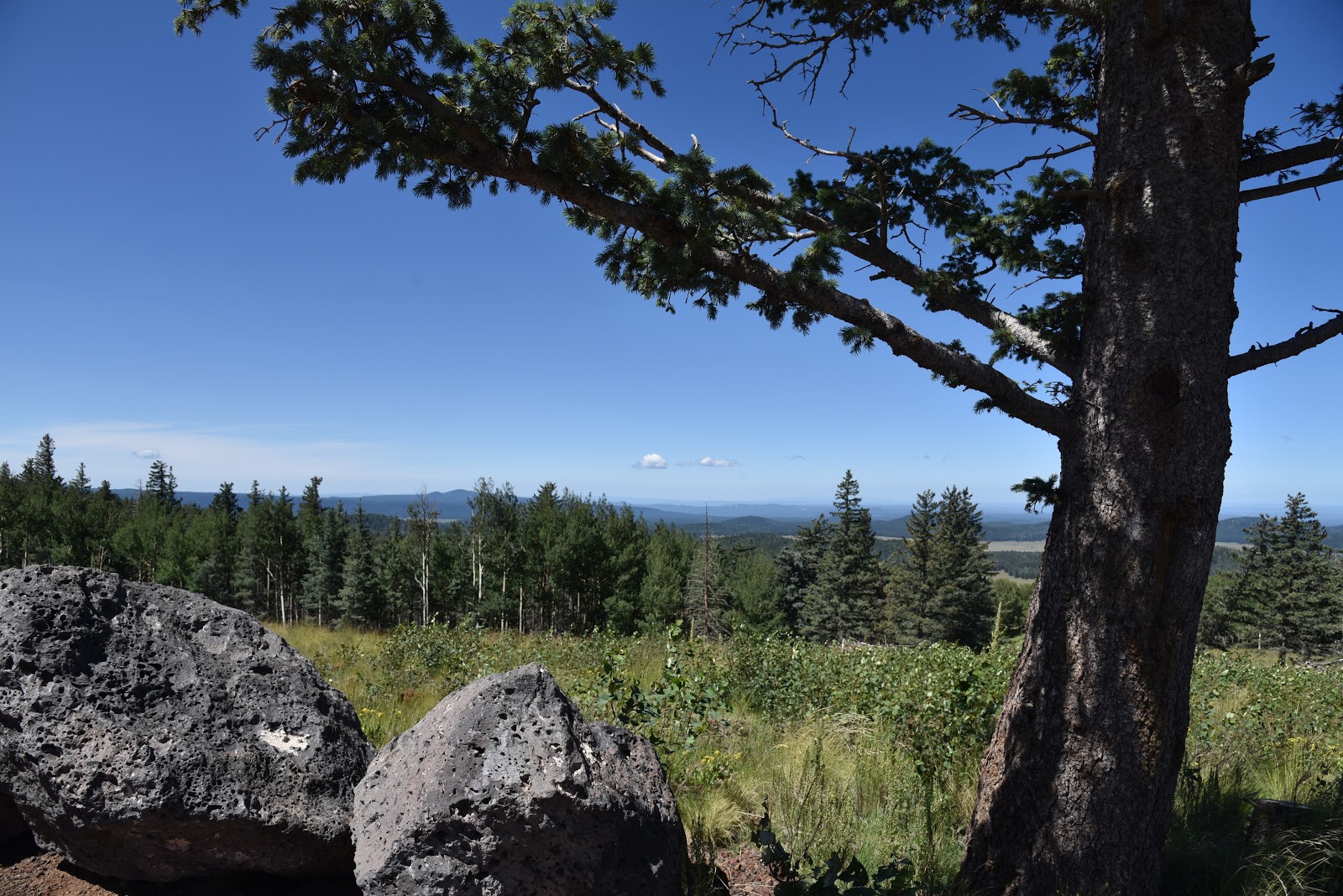
Look for surrounding hike hubs like Pole Knoll, Mount Baldy (11,420 feet) and the trails around Big Lake. Near the top, the distinctive profile of Escudilla Mountain (10,912 feet) that sits near the New Mexico border shows a frenzy of aspen resurgence in the scar of the 2011Wallow Fire.  On the summit, a fire lookout and communication towers rise above the coniferous woodlands that cover the mountain’s northeast flanks.
Greens Peak seen from nearby Fence Tank corral.
To the south, the web-like patterns of ski runs at Sunrise Park Resort near Greer stand out above a landscape of misshapen volcanic bluffs, mounds and eroded cones.
Cattle graze in meadows at the base of the mountain.
The mountain’s breezy high-elevation edges are also ideal for birdwatching or spotting herds of pronghorn, elk and ubiquitous cattle roaming among lumpy grasslands and watering holes below.
A fire lookout and communication towers on the summit
LENGTH: 2 or 4 miles roundtrip
RATING: moderate
ELEVATION: 9,520 – 10,134 feet
GETTING THERE:
From Pinetop-Lakeside, travel east on State Route 260 (toward McNary).  Continue to roughly 3 miles past State Route 273 to Forest Road 117 near milepost 380 on the left (about a mile past the Railroad Grade trailhead).  Follow FR117 north for 3 miles to a "Y" junction at Forest Road 61 where a sign reads “Greens Peak 2 miles”. You can park here for a 4-mile roundtrip hike or veer left and drive another mile to the next “Y” intersection at FR61/61C
for a 2-mile hike.  Roads are maintained dirt and cinder and passable by sedan.
INFO: Arizona Geological Survey
Arizona Wildlife Trails: