Find A Trail. Start Your Search Here:

Monday, August 26, 2024

Quaky Trail No. 741

QUAKY TRAIL No. 741

Quaking aspens on the new Quaky Trail No. 741

It’s only a mile long, but the new Quaky Trail No. 741 in Prescott National Forest is a handy addition to the Bradshaw Ranger District routes in the Copper Basin Area. 

Quaky Trail traces Aspen Creek

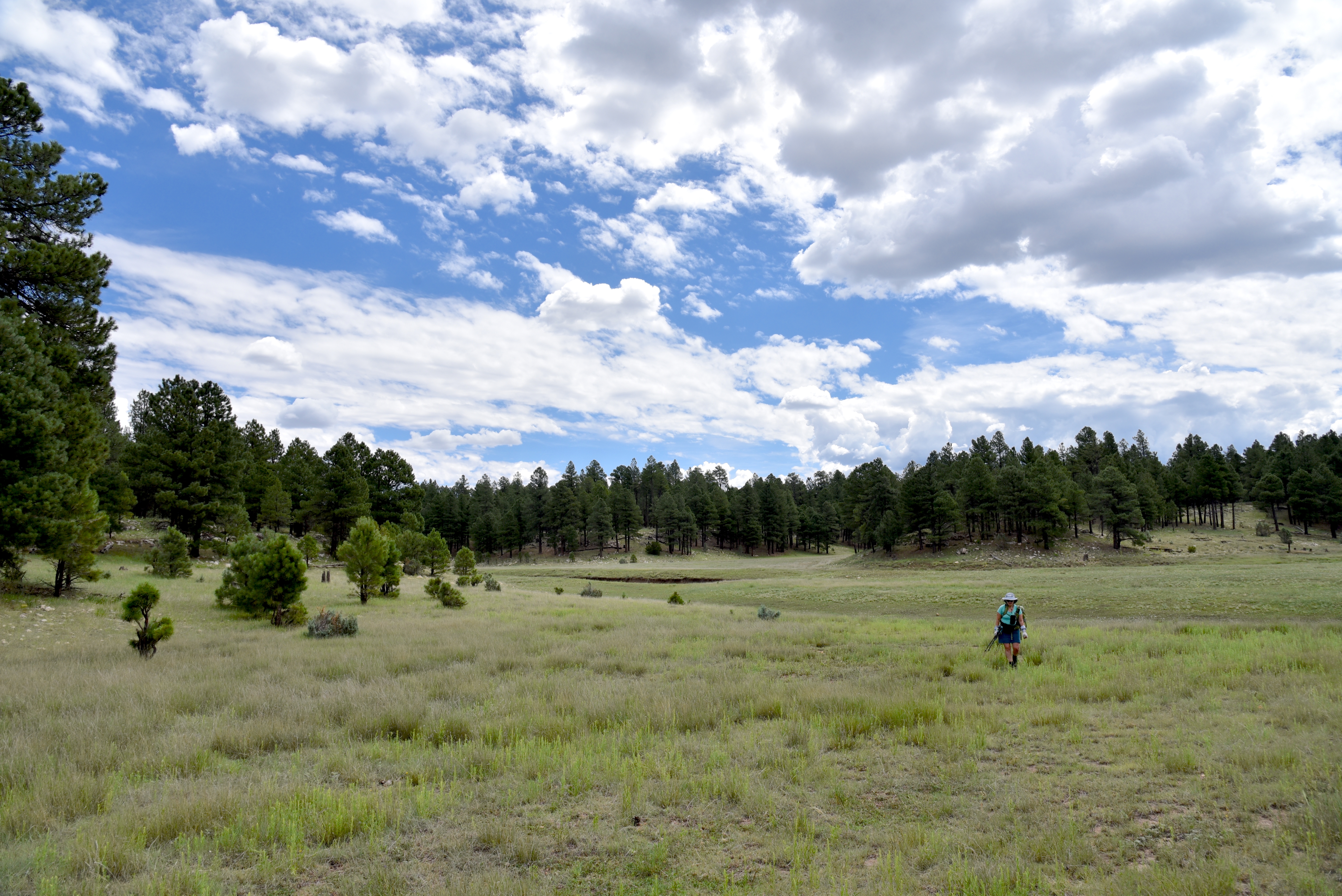
Opened this summer, the new single-track path is located just a few miles from Downtown Prescott and provides connectivity with several popular forest trails like Wolverton Mountain as well as the 51-mile Prescott Circle Trail. 
Quaky Trail connects with popular routes

The fresh-cut Quaky Trail may be accessed from either the Aspen Creek Trailhead or the nearby new Copper Basin Trailhead which will have room for equestrian trailers when completed in late August.
New Copper Basin trailhead offers trailer parking

 Either way, the trail is a beautiful work of construction.  From the Aspen Creek Trailhead, the hike begins with a 0.2-mile walk on Aspen Creek Trail No. 48. 
Butterfly weed blooms May - September

Trail no. 741 heads right following the course of the creek. 
The aspen passage on Quaky Trail

The entire route is shaded by Ponderosa pines and creekside stands of boxelders, locust and oaks with an understory of brambles and wildflowers. 
Ponderosa pines on Quaky Trail

The edgy route twists through the forest dodging boulders and skimming ravines before encountering a gorgeous passage lined with aspen trees.  
Quaky Trail spins off Aspen Creek Trail No. 48

The white-trunked quaking aspens (presumably the “quakies” of the Quaky Trail) huddle in tight formation, their canopies rustling in the mountain breezes. 
Quaky Trail is richly shaded

This is a good trail to keep in mind for October autumn foliage hikes.  The trail ends at the Copper Basin Trailhead where hikers may double back or consult forest maps to extend the trek.
Fleabane grows along Aspen Creek May-October

LENGTH:  2.4 miles out-and-back

RATING: moderate

ELEVATION:  6,341 – 6,614 feet

GETTING THERE:

ASPEN CREEK TRAILHEAD:

From Courthouse Square in Prescott, go 1 mile south on Montezuma Street (turns into State Route 89/White Spar Road) to the traffic light at Copper Basin Road.  Turn right and continue 4.6 miles on Copper Basin Road (turns to good dirt after 1.6 miles) to the Aspen Creek trailhead on the right. The hike begins across the road on Trail 48. No facilities.

COPPER BASIN TRAILHEAD:

Located 0.2-mile past the Aspen Creek Trailhead on Copper Basin Road. No facilities.

Copper Basin Road is maintained dirt suitable for all vehicles up to the trailheads. 


Wednesday, August 21, 2024

The Hike Book Vol. 4

PHOENIX Magazine The Hike Book Vol. 4 is here!


My latest collection of Arizona hikes.
AVAILABLE ONLINE NOW.
In stores in the coming weeks at:
Sprouts
Whole Foods
Wide World of Maps
Just Roughin It
AZ Hiking Shack
REI
Changing Hands Bookstore
Barnes and Noble

Monday, August 5, 2024

Willow Valley Dam

WILLOW VALLEY DAM

Sign on FR9352Q

Willow Valley on the Mogollon Rim is best known for its narrow, cliff-bound course. Rugged back country trails including Maxwell, Tramway, Calloway and the milder Willow Crossing lead into its chiseled sandstone depths in West Clear Creek Wilderness. At its lower reaches, Willow Valley merges with Clover Creek where both empty into West Clear Creek.

Bar D Corral on FR 93

Experienced, well-equipped hikers must brave rough roads, sketchy vertical descents, wading and scrambling to explore the wilderness end of the Coconino National Forest valley located roughly 40 miles south of Flagstaff.
Flat Draw Tank near Bar D Corral


But the valley’s upper reaches in the Plateau Lakes region southeast of Mormon Lake are a whole other story.  On the windy expanse, the valley is a shallow, yawning break in the landscape, hemmed in by fringes of Ponderosa pines. 

Calliopsis bloom June - September

It’s a beautiful, more accessible side of the valley. Replete with water holes, corrals and a maze of dirt roads, the bucolic slice of forest stands in stark contrast to its deeper, wilder end.
Scene along FR 93

A few miles south of the community of Happy Jack, off Lake Mary Road, Forest Road 93 serves as a route to Willow Valley Dam and a quiet pocket of forest that’s easy for just about anybody to explore on foot.

The hike follows Forest Road 93, a level dirt track with lots to see along the way. 

Wild geranium bloom May - September

At the 0.75-mile point, the road meets Bar D Corral, a collection of barbed wire, fencing and other cattle roundup structures.  Nearby, the glassy pools of Flat Draw Tank reflect trees and sky while providing water for wildlife and domestic cattle. 
Willow Valley scene on FR234C

Another mile, and the road comes to Wingfield Corral with its tangle of fencing and complex construct of metal and wood.  At the  north end of the corral, a secondary dirt road heads east. 
The breached Willow Valley Dam

It’s not signed, but this is Forest Road 234C, a 0.2-mile route that crosses over Willow Valley south of the dam. It’s a fun detour, but to get to the dam, skip FR234C and continue 0.2-mile past the corral and head right on Forest Road 9352Q which is open only to foot travel. 
Puddle in the break of Willow Valley Dam

The 0.3-mile dirt road ends at a grassy swale.  Open to the sky, the wide depression is also known as Willow Valley Lake. 
While rain-scoured channels and ample greenery hint that water occasionally runs through, the Willow Valley Dam that had contained the “lake” has partially collapsed. 
Willow Valley Dam seen from FR 9352Q

The earthen embankment is still impressive, though. Its shrub-encrusted walls stand high above the valley with ephemeral puddles at its base. 
Willow Valley "Lake" is a moist swale

Wildflowers thrive in the moist soil and robust elk tracks suggest that the site is still an important wildlife resource.  
Wingfield Corral on FR 93

Forest Road 9352Q continues up a knoll to a shady overlook above the dam that frames picture perfect views of a snippet of Willow Valley’s origin story.

LENGTH:  6 miles roundtrip (out-and-back to the dam beginning near Lake Mary Road)

RATING: easy

ELEVATION:  6,924 – 6,745 feet

GETTING THERE:

From Flagstaff, go 42 miles south on Lake Mary Road (County Road 3) to Forest Road 93 on the left past milepost 302 signed for Willow Valley Dam.  Park along any of the dirt turnouts or dispersed camping sites along the road.  FR93 is maintained dirt suitable for all vehicles for about a mile. After that, high clearance is recommended.

Monday, July 15, 2024

Iron Spring Connector-Leap Frog Trail

IRON SPRINGS CONNECTOR-LEAP FROG TRAIL

Hikers on the Iron Springs Connector Trail

Trails in the forests around Munds Park cater to visitors of many ilks. 

Frog Tank in the Munds Park Trail System

The slice of Coconino National Forest 20 miles south of Flagstaff is home to the Munds Park Trail System and the Kelly Motorized Trail System.  Both systems of looped trails fill the space between Interstate 17 and the Sandy’s Canyon area on Lake Mary Road with over 100 miles of recreational routes.  
Horse Park thinning project on Leap Frog Trail

Whether used for hiking, mountain biking or off-road motorized travel, the system’s menu of short and long loops makes for an ideal outdoor fun destination.  The Munds Park Trail System has several convenient trailheads located just a few miles east of Interstate 17. 
Lizard strikes a pose on Iron Springs Connector

The Iron Springs Trailhead offers quick access to the area’s most popular trails, the Mud Tank Trail and the Frog Tank Loop.  Also departing from the same trailhead, the Iron Springs Connector is a rocky two track that’s open to hikers, bikers and smaller OHVs. 
Ponderosa pines shade Frog Tank Loop

The mile-long route may be used as the first leg in any number of out-and-back or loop hikes.  The trailhead kiosk has maps showing the layout of both systems. 
Oaks and pines on Iron Springs Connector

The Munds Park trails are mostly rated as easy-moderate and are short in length while the Kelly trails are designed for OHV use and are longer and more difficult.  All the trails wander through Ponderosa pine forests with patches of sunny meadows and lots to see.
Wild bergamot blooms in moist areas

For a moderate out-and-back day hike, follow the Iron Springs Connector to the Frog Tank Loop junction.  Go right at the junction and follow the trail that’s also open to motorized use, downhill to where it crosses a drainage replete with summer wildflowers and tiny pools. 
Domestic cattle share the trails

At 0.2 mile from the Frog Tank Junction, the trail meets a 3-way intersection.  Continue straight onto the Leap Frog Trail #246 which is also known as the Buried Cable Trail.  The trail is not signed here, but utility posts along this 0.3-mile segment serve as identifiers.  At the 1.5-mile point, the trail reconnects with the Frog Tank Loop.  Leap Frog trail continues north, but for a scenic detour, head left and make a 0.4-mile round trip walk to Frog Tank.  The watery enclave is a wildlife-magnet at the edge of a sunny green swale.  The pretty site attracts waterfowl, birds, elk and meandering domestic cattle. 
Apache Maid Mountain on horizon

Leap Frog Trail is a 9.5-mile route that twists north, roughly paralleling I-17 before swinging east to Connect with the Rocky Road Trail that leads to Mud Tank and back to the Iron Springs trailhead.  But for those not looking to do a half marathon style trek, a good turnaround point for a hike under 5 miles is Forest Road 78A. 
Mormon Mountain seen from Leap Frog Trail

We ventured about a half mile beyond the junction where the Leap Frog trail continues across FR78A at a nondescript Kelly Trail signpost and begins a moderate climb through the current Horse Park forest thinning project. 
Cattle graze along Leap Frog Trail

The Coconino National Forest logging project is part of an effort to reduce fire danger by removing forest fuels, restore habitats and improve forest health. Cut trees and log piles are visible long this segment. The thinning project has also opened mountain vistas. 
Wright's bluets bloom May - September

The silhouettes of 8,456-foot Mormon Mountain and 7,307-foot Apache Maid Mountain peek out from a fringe of tall pines and Gamble oaks, a sampling of what the higher elevations might have in store for strong hikers and brave ATV drivers.  
Iron Springs Trailhead in Munds park

LENGTH:  4.6 miles out-and-back to 78A as described here with side trip to Frog Tank

RATING:  moderate

ELEVATION: 6,565 – 6,625 feet

GETTING THERE:

Iron Springs Trailhead:

From Interstate 17 in Munds Park, take the Pinewood Blvd (Forest Road 240) exit 322 and continue 0.8 miles to Crestline Road. Turn left and go 0.8 miles (road will turn into Oak Dr.) to Iron Springs Road, turn right and go 0.5 mile to the trailhead.  Trailhead road is maintained dirt suitable for all vehicles. There are no fees or facilities at the trailhead.

Munds Park Trail System:

https://mundsparktrailstewards.com/maps/

Coconino National Forest Thinning Info:

https://www.fs.usda.gov/detail/coconino/landmanagement/projects/?cid=stelprdb5417804

Monday, June 17, 2024

Headwaters Trail

HEADWATERS TRAIL 

A "beach" at West Clear Creek

Of all the hiking routes that descend into West Clear Creek Wilderness—Willow Crossing, Tramway, Maxwell, and the eponymous West Clear Creek Trail---the Headwaters Trail is the most challenging. The 13,600-acre wilderness spans the Red Rock and Mogollon Rim ranger districts of Coconino National Forest.
Sunrise in seen from West Clear Creek

Along its 20-mile length, which is defined by the steep-walled canyon carved by West Clear Creek, the terrain moves through high desert at its lower edge near Camp Verde where it spills into the Verde River to pine-oak woodlands at its headwaters on the Mogollon Rim near Clints Well.
Headwaters Trail is steep and slippery

Steep, scrappy and often obscured by pine needles, the half-mile Headwaters path makes an abrupt plunge into a canyon-bound stretch of the creek.

Dogwood and willows along West Clear Creek

Sometimes called the Point Trail, the short access path is favored by anglers and campers that hang out on the shady rim 600 feet above the perennial waterway. 
Hanging gardens on West Clear Creek

The climb down is convoluted and slippery, ducking among conifers, oaks and moss-encrusted boulders. The primitive trail drops onto a beach where red-osier dogwood and willows sink roots into the debris strewn water course. 
Anglers and hikes in West Clear Creek

Extending the hike beyond the butt-slide descent involves wading and using foot paths that wend around the creek’s edges in the shadow of towering cliffs.  Exploring may be done either up or downstream.
Wading is required to explore along the creek

From the point where the trail lands on the beach, head left to see the famous “hanging gardens”, limestone cliffs draped with drooping green plants that sway over shallow depressions in the rock walls. Or, go right and follow the waterway to a gallery of ancient rock art. 

Wilderness wonders of West Clear Creek

All told, the stunning scenery of this near the headwaters of West Clear Creek makes the difficulty of getting to it worth the effort.  

LENGTH: 1-mile roundtrip (from the rim to the creek)

ELEVATION: 6,600 – 5,950 feet

RATING: insane

GETTING THERE: From Payson, go north on State Route 87 (toward Pine-Strawberry) to State Route 260. Turn left (west) and continue 3.1 miles to Forest Road 144, near milepost 249. Turn right (east) and go 1.8 miles to Forest Road 149, turn left (north) and continue to a 3-way junction at Forest Road 142. Go right onto FR 142 and drive 0.9 miles to Forest Road 142E on the left---this is an easy-to-miss unmarked road—if you reach Forest Road 142F, you’ve gone too far. Follow FR 142E 2.7 miles to a large, unsigned parking area. Roads are rough dirt and gravel. High clearance vehicles required.

INFORMATION: refer to the Coconino National Forest map, USGS map, Calloway Butte


Tuesday, May 28, 2024

Ridgeline Circuit

SPECKLED RATTLER-CRANKSET-RIDGELINE CIRCUIT

View from the Ridgeline Trail

Summer hiking is Arizona is an endeavor that takes extra effort.  While making long drives to the high country to escape the Valley heat is an ideal solution, road trips to pine-shaded hiking trails are not always feasible. 

View of Golden Cliffs Trail from MUP-A

But hikers got to hike.  By applying a large dose of common sense and doubling down on safety precautions, summer hiking in the desert is doable. 
Trails are well-marked in Paloma Regional Preserve

Of the many safeguards needed to stay alive in summer heat, three are of paramount importance:  timing,  sun protection and, water, water, water.  First, plan to hit the trails early and be done by 8 a.m. or before the dangerous heat kicks in.  
Ridgeline spur to overlook

Many local parks and preserve open at sunrise, so plan accordingly.  One of the most misunderstood elements of desert hiking involves proper attire. 
Knoll with spur trail overlooking the park

An investment in a brimmed hat, long sleeve shirts and long pants made of sun-protective technical fabrics will pay off big time.  These fabrics not only shield against sunburn and insects, but they also act like evaporative coolers to keep moisture on your skin. Yup, you’ll feel cooler in long sleeves than a tank top. Then there’s water.
Paloma Community Park from Ridgeline trail

Bring plenty, more than you think you’ll need. I personally carry nearly a gallon for a 3-hour desert hike.  This includes two 16-ounce bottles that I almost always end up giving away to heat stressed hikers. Dogs will get my extra water first.  
Speckled Rattler Trail junction

And, speaking of dogs—leave then at home. Heat is brutal on canines. Our furry friends suffer burnt paws, heat exhaustion and even death on local trails every year.
Saguaros on the Ridgeline Trail


With the objective of being up-and-out by 8 a.m., hikers can maximize the effort by choosing trails with easy access, some moderate challenge, bail out options and fantastic views.  The trails of the Paloma Regional Preserve in Peoria exceed these criteria.  A good early morning summer circuit uses the Multi-Use Path-A, Speckled Rattler, Crankset and Ridgeline trails. 

Tight bend on Ridgeline Trail

From the trailhead, the route follows MUP-A for 0.4-mile to Speckled Rattler and then connects to Crankset. This first 1.57-mile leg is flat, tracing the base of West Wing Mountain with the cut of the Golden Cliffs trail visible on the slopes. 
Valley vistas from Ridgeline Trail

A large map kiosk marks the junction with the Ridgeline trail, where the route begins its climb.  At the top of the first of several sets of switchbacks, the trail splits.  The left arm heads up a craggy knoll for a short trek to an overlook above Paloma Community Park, a nice little diversion.
Green corridor of New River below Ridgeline

 
View from Ridgeline overlook spur

The route then traverses a saguaro dotted ridge, swooping uphill in flowing curves and tight turns engineered to make the going almost effortless.  Views grow larger and more varied as the trail ascends to its highest point.  The green swath of New River fills the valley below while a ring of mountain ranges surrounds the horizon.
Long switchbacks mitigate the climb

The trail then spirals down to its end point at marker 90,the turnaround point for this trip.  To build a loop or shorten the hike, download the preserve trail map and keep an eye on the time, your water supply and how you feel.  The goal is always to get back to the trailhead alive.


LENGTH: 5.7 miles (out-and-back, as described here)

RATING: moderate

ELEVATION: 1,393 – 1,850 feet

GETTING THERE:

297799 N. Lake Pleasant Parkway, Peoria.

From Interstate 17 in Phoenix, take the Loop 303 exit 221 and continue west to Lake Pleasant Parkway.  Turn left and go 1 mile to the Paloma Community Park entrance on the left.  Follow the signs to the trailhead parking area.  There are restrooms near the trailhead. No Fees.

HOURS: sunrise to sunset daily

INFO & MAPS:
City of Peoria

peoriaaz.gov/government/departments/parks-recreation-and-community-facilities/parks-and-trails/hiking-trails