


BOTTOM OUT - ROUNDABOUT LOOP
 |
| A typical scene on the Bottom Out trail |
Usually, getting to the good stuff takes effort.
 |
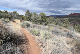
| The beginning of the Bottom Out trail is just an appetizer |
This is especially true of hiking where the juiciest routes are often remote, tangential paths diverging from heavily traveled routes in popular outdoor destinations.
While many trail systems offer groomed and signed paths that range from super easy to difficult, the unpolished character of a place often resides at the raw end of the spectrum.
 |
| Easy going on the Roundabout trail |
Sedona’s Western Gateway Area trail system builds on this theme with a
serpentine maze of interconnected loops that straddle a hilly pocket of Coconino National Forest on the far west side of town. But instead of its wild side being inaccessible to most, this system’s rough-cut gem spins off an easy trail less than a mile from a trailhead and appeals to hikers with a sense of adventure, experience and sturdy boots with good traction.
 |
| Bottom Out trail traces Dry Creek |
The compact system of singletrack paths unwinds around the chiseled course of Dry Creek where the terrain shuffles among high ridgelines with epic vistas of Red Rock County’s iconic rock formations, fractured drainages, cypress and oak woodlands and sunny yucca-studded grasslands. Comprised of short, connecting segments, the trails don’t linger too long in any one ecozone.
 |
| One of the many obstacles on the Bottom Out trail |
 |
| A riparian zone in Dry Creek seen from Bottom Out trail |
Instead, they soar over exposed ledges, dip into gullies and ramble through leafy riparian corridors in seamless, smooth-moving cycles.
 |
| Bottom Out trail dodges a gorge on Dry Creek |
To sample the best of the system’s highs and lows in one swooping loop that runs through the system’s aforementioned raw end, try a circuit that uses the Bottom Out and Roundabout trails. These two trails reside in the system’s south central core just steps from the Cultural Park trailhead off State Route 89A. Finding the route is a bit confusing at first. Begin with a short walk on the Girdner trail, then head right onto the Outer Limits trail. Cross a dirt road and veer left to continue another 0.3-mile on Outer Limits to the Bottom Out junction. A wooden sign post points into a dry wash. If the beginning a the Bottom Out trail looks sketchy—wait. That’s just an appetizer.
 |
| Girdner trail is used as a connector path on this circuit |
The route is a veritable roller coaster of obstacles, down-climbs and stony passages. Completely devoid of signage, the 1.3-mile trail is a joy for those who prefer less-travelled trails with a few baked-in challenges. Rated difficult for hikers and very difficult for mountain bikers, the ragged route roughly traces Dry Creek, which usually lives up to its name.
 |
| A slickrock passage on Bottom Out trail |
It’s essential to pay attention to route-finding on this one where the trail dives deeper into the creek corridor. The trail is sometimes in the creek, sometimes on ledges above and sometimes slipping over slickrock, all the while crossing from bank-to-bank with no particular agenda.
 |
| Rock ledges on Roundabout trail |
 |
| Bear Mountain viewed from Roundabout trail |
The most fun parts of the trail are the rock jams and drop offs that must be worked around using creative route scouting. Mostly canyon-bound and shady, the Bottom Out trail delivers its deepest and final stony obstacle just before it exits the creek corridor and begins a short uphill crawl out of the sheer-walled canyon.
 |
| Point where Bottom Out trail leaves the canyon |
The mild climb ends back on the Girdner trail junction where views of the Cockscomb formation and Bear Mountain stand out to the north. Each trail junction has an excellent map sign for customizing hikes. For this circuit, head right and follow Girdner 0.6-mile to the Roundabout trail.
 |
| Route-finding skills are needed on Bottom Out trail |
The Roundabout leg of the hike is an easy-rated, entertaining muddling of tight bends and edgy traverses all backed by a carousel of changing views that include Mingus and Woodchute mountains, distinctive Capitol Butte and the long mesas of Wilson Mountain. Sort of like an inside-out version of the Bottom Out trail, this 1.7-mile segment trades a viewless, cloistered obstacle course with an easy glide on open terrain with big mountain vista.
 |
| There are no signs like this one on Bottom Out trail |
And, unlike the hunt-and-peck nature of its companion, a clear path and excellent signage guide hikers home without a single obstacle in the way.
LENGTH: 4.1-mile loop (as described here)
RATING: moderate-difficult
ELEVATION: 4,154 - 4,492 feet
GETTING THERE:
Girdner-Cultural Park trailhead.
From the State Route 89A/179 traffic circle in Sedona, head 4.2 miles west (go left through the circle) on 89A to Cultural Park Way (traffic signal). Turn right and continue 0.3-mile to the Girdner Trailhead on the right. Trailhead has picnic tables and a map kiosk but no restrooms or water.
INFO:
https://www.fs.usda.gov/coconino/
No comments:
Post a Comment