CRACKERJACK ROAD
 |
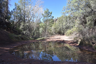
| The FR 209 crossing of the East Verde River |
From its source on the Mogollon Rim near Washington Park north of Payson, the East Verde River flows southwest through Tonto National Forest, feeding a gorgeous swath of greenery before merging with the Verde River.
 |
| The first part of the hike follows Ash Creek |
Over its 34-mile length, the central Arizona waterway cuts through a transitional landscape where the desert creeps up against sheer rock escarpments at the edge of the Colorado Plateau trickling down from an environment of tall pines and forest lakes into high desert scrub and rugged backcountry of the Mazatzal Wilderness.
 |
| Milk vetch is a common bloomer along the hike |
Where the tributary stream wraps around Houston Mesa Road at its confluence with Ellison Creek, the Water Wheel group of recreation sites attract anglers, bathers and hikers.
 |
| Riparian corridor of the East Verde River |
Those who don’t mind crowds, noise and hefty day-use fees will have a blast at these splashy, easy-access hot spots. But for a less congested look at the waterway’s midsection, take a stroll on a nearby back road.
 |
| FR 209 crosses Ash Creek several times |
More plod than plunge—don’t bother packing a swimsuit-- this moderate hike follows Forest Road 209 that’s also known as Crackerjack Road.
 |
| Sycamore and chiseled cliffs line FR 209 |
The dirt track, which is part of the Payson OHV Trails system, begins 3 miles north of town off State Route 87. From the highway, it’s just over a 3-mile hike to the East Verde, but it’s the stuff in between that makes this walk memorable.
 |
| Crossing at the East Verde River |
 |
| Seeds of an ash tree |
The road traces the course of Ash Creek, crossing it several times as it makes a gentle descent through pine woodlands. The first mile passes by many campsites used by OHV enthusiasts but soon leaves the party scene behind and enters a stunning, canyon-bound riparian corridor.
 |
| Shaggy, green-white bark of an AZ sycamore |
Lined with sycamores, cottonwoods and the eponymous ash trees, the trip unpacks amazing views of sculpted cliffs and scoured ravines. At the 2-mile point near where some powerlines cross the route, the road emerges from the deep woods around Ash Creek and heads uphill where the gaping gorge of Horton Canyon stand out to the south.
 |
| Fresh sprouts on an ash tree |
At the top of a rise, first glimpses of the river’s emerald entrenchment winding past the East Verde Estates community come into view. To the north, peeks at the distant flat-topped Mogollon Rim barely rise above a terrain of endless gullies, hills and juniper flats. From this point, the road dips downhill paralleling the river’s flood plains.
 |
| Vegetation thrives along Ash Creek |
 |
| The road heads uphill near Horton Canyon |
Corralled by colorful stone embankments rubbed smooth by running water, the East Verde River crossing is a beautiful little place with room to explore along its banks.
 |
| Gregg's ceanothus shrubs smell like lilacs |
Still pools, clear cascades and tumbling mini waterfalls reflect russet rock walls and leafy fringes for many perfect photo opps.
The hike turnaround point is where clumps of reeds and saplings encroach upon a concrete slab that spans the water and a Salt River Project water monitoring station stands near a massive cottonwood tree. For a longer albeit dryer and hotter hike, follow the road another 4 miles to the Crackerjack Mine site, otherwise, backtrack and enjoy the watershed in reverse.
 |
| Peaceful scene along the East Verde River |
LENGTH: 6.4 miles round trip to the river and back.
RATING: moderate
ELEVATION: 4,389 – 4,831 feet (1,083 feet of accumulated gain)
GETTING THERE:
From the State Route 87/260 junction in Payson, go 3 miles north on SR 87 to Forest Road 209 at milepost 256 on the left. Park in the dirt turnout or continue along FR 209 to one of the many parking aprons and campsites along the road. The road is sedan-friendly for about one mile.
INFO: https://www.tralaz.org/


No comments:
Post a Comment