HUMBOLDT
MOUNTAIN
Sometimes
I just feel like a brainless hike up a hill with no route finding,
treacherous terrain or precarious precipices. Just. Up.
Thankfully, Humboldt Mountain meets this criteria and it's not too
far from downtown Phoenix. You've probably seen this hill and
wondered about it ---there's a huge, white “golf ball” (as it’s
commonly called) on the summit that’s visible from the back roads
north of Cave Creek and Carefree. The white ball, which is an FAA
radar station used for air traffic control, shares the summit with a
fire tower and a hardware jungle of tech equipment. The hike involves
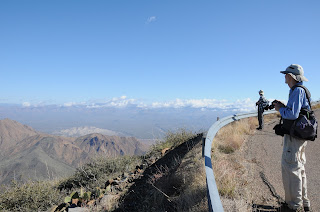
walking up a narrow road of crumbling asphalt via a series of gentle
switchbacks and a combination of flat and fairly steep segments.
The 2005 Cave Creek Complex Fire took a toll on the area's
vegetation, but recovery is underway and desert shrubs are popping up
everywhere. With every few feet of elevation gain, the views get
bigger and better. Much of the lower road winds through
cactus-studded grasslands with Cave Creek Mountains, Pinnacle Peak
and New River Mesa on the horizon. Higher up, the road winds around
to the eastern slope of the mountain where there the sprawling Verde
River Valley and Horseshoe Lake come into view. Just below the
summit, the one and only hairpin turn in the road kisses the edge of
a scenic saddle. Here, sycamore-and-cottonwood cluttered drainages
appear as twisted meanders nearly 2,000 feet below. From this
saddle, the final uphill slog to the summit rewards with more
excellent views and the revelation that “golf ball” is hardly an
accurate description of the FAA tower. It is most indubitably, a
soccer
ball.
 |
| Summit views |
 |
| Final switchback to the top |
LENGTH:
7.8 miles roundtrip
RATING:
moderate
ELEVATION:
3,570' – 5,204'
BEST
SEASON:
October – April
From
Loop 101 in North Scottsdale, take the Pima/Princess Road exit and go
13 miles north on Pima Road to Cave Creek Road. Turn right
(east) and continue on Cave Creek Road (a.k.a. FR 24, Seven Springs
Road) to FR 562 (Humboldt Mountain road) located between MCDOT mile
markers 9 and 10. The turnoff is easy to miss—it’s on the
right, paved and there’s a “562” sign about 100 feet up the
road. If you get to Seven Springs Recreation Area, you have gone
roughly 2 miles too far. Park in the turnouts along FR24 and FR562
and hike up FR562 to the summit.
INFO:
Cave Creek Ranger District, Tonto National Forest, (480)
595-3300


No comments:
Post a Comment