PYRAMID TRAIL
South Mountain Park, Phoenix
One year from today, the Maya Long Count Calendar will complete its 5,125-year cycle, triggering the End of the World. Time for a HIKE!
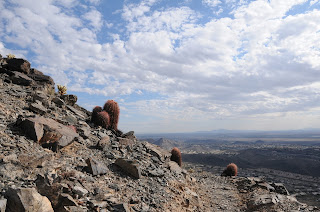
From the desert floor beneath the triangular-shaped peak that dominates this trail, a zig-zagging path ascending its west face looks like steps on a Mayan temple-- a chiseled, deliberate skyward trek. With my imagination stoked by a recent viewing of the Mel Gibson film Apocalypto, I trudged up this hill in the waning days of 2011 wondering about the impending doom predicted by the Maya Long Count Calendar. According to ancient Maya astronomers, on the winter solstice 2012 (12-21-12, 11:11 p.m. UT --4:11 p.m. in Phoenix) our sun will align with the center of the Milky Way, triggering cosmic chaos and the end of the world. Apparently, the City of Phoenix did not get Quetzalcoatl's memo and went ahead with a major land purchase in 2009, adding the Pyramid and Bursera trails (both completed in 2011) to the Ahwatukee side of South Mountain Park. However, other than its name and Mayan-esque physical characteristics, this trail has nothing at all to do with the demise of the universe. Instead, it's full of life, a joy to hike and would make for an excellent 2012 New Year's Day hike---because of the end of the world and all. (eh-hum, back to hiking) The first mile is an easy walk among cactuses, creosote and ironwood-cluttered arroyos just yards from the backyards of a residential area along Pecos Blvd. The trail then swerves away from the homes, taking on the pyramid via switchbacks that go from elongated and effortless to short and grinding. Passing cliffs where cholla and barrel cactuses cling to bare rock, the trail hugs the edge of the hill for expansive views of the Sierra Estrella Mountains and the cotton fields of the Gila Indian community. After topping out on an isolated stony outcropping, the path then makes a minor dip onto a saddle then goes up again toward an array of towers near where it connects with the National Trail.
Whether or not the Maya (or other) theory of 2012 armageddon comes to fruition, this trail is as good a place as any to witness stellar cataclysm--or make a dent in a new year's resolution to get more exercise.
 |
| Arroyo on the Lower Trail |
LENGTH: 6 miles roundtrip
RATING: moderate
ELEVATION: 1,235' – 2,337'
DOGS: leashed dogs allowed
GETTING THERE:
From Phoenix, take I-10 south/east (Tucson) to exit 161 for Pecos Road. Drive 7.2 miles west (right) on Pecos to 17th Avenue. Head north (right) on 17th Ave. and continue 0.7 mile to where 17th Ave meets Chandler Blvd. Turn left here and go 0.3 mile to the end of the road where a generic "trail" sign marks the trailhead.
HIKE DIRECTIONS:
From the trailhead, begin by hiking west, making a sharp right a few yards in. Continue 0.44 mile to the junction with Bursera Trail. Here, go right (east) and continue 2.6 miles to trail's end at the junction with National Trail. NOTE: there are a couple of junctions marked only with plain brown posts---at these, just head toward the peak.
INFO: City of Phoenix Parks & Recreation
MAPS:


No comments:
Post a Comment