Find A Trail. Start Your Search Here:

Monday, October 24, 2022

On the Suburban-Wildland Interface: 136th Street Trail

136th STREET EXPRESS TRAIL

Saddle Mountain (right horizon) seen from 136th St. Trail

People suck.  It seems this barb gets spit out by hikers more so than by any other category of humans. The misanthropic affront appears on t-shirts, stickers and hats, the wearers oblivious to the irony.

Tonto National Forest mountains on horizon

While I don’t presume to know what’s going on in the heads of hikers who hate people, I kind of understand why they feel that way.

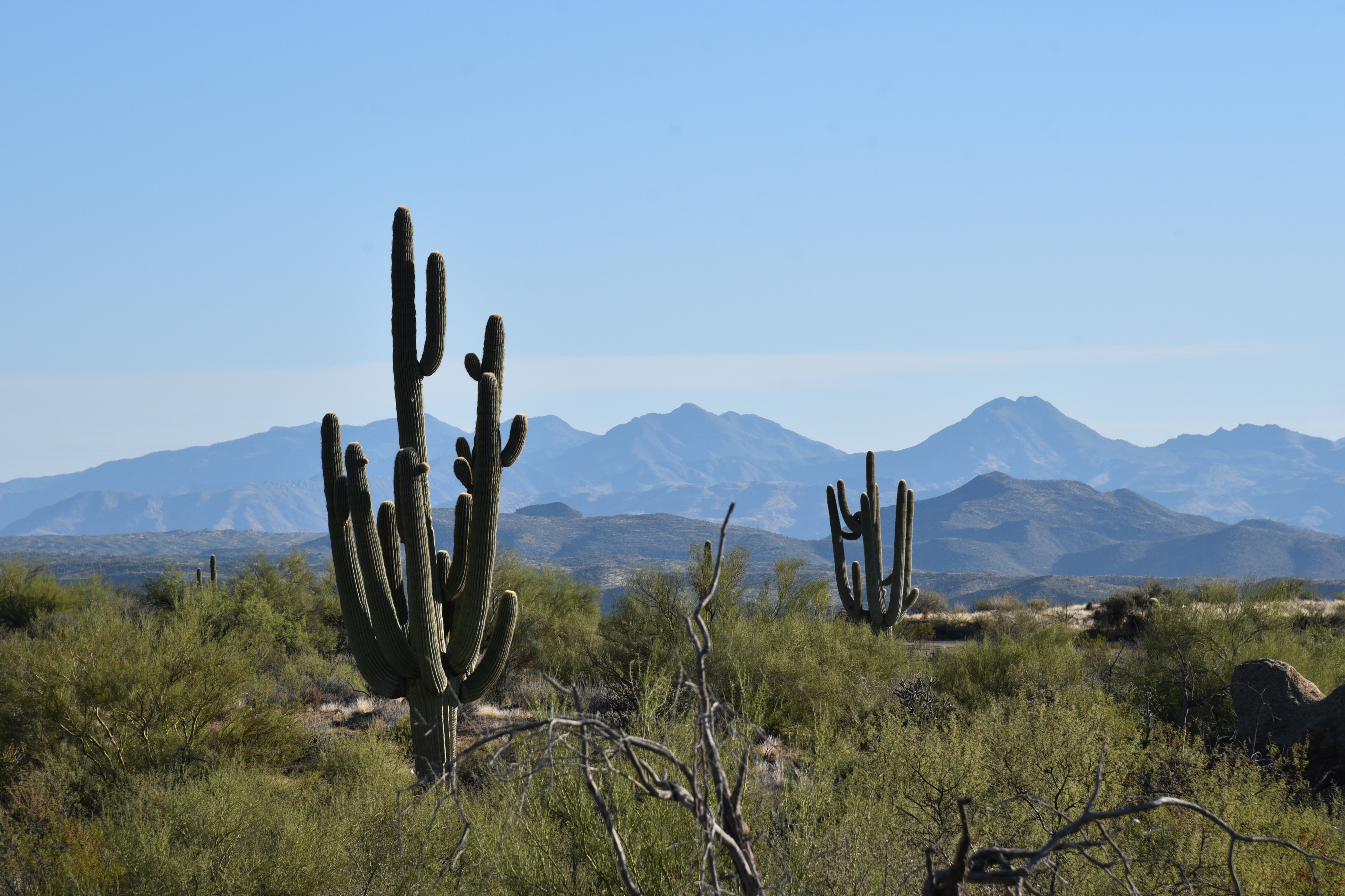
Saguaros clutter at the base of Granite Mountain

 Trail overcrowding, trash, graffiti, suburban sprawl, noisy groups and the guy who overdosed on Bleu de Chanel cologne is enough to drive anyone over the edge.  While cathartic, an all-purpose vent is like a self-fulfilling prophesy.  Embrace negativity, and that’s what you’ll get.
Bee gathers pollen on a turpentine bush

While the world does host a fair number of certifiable boneheads, most people are alright. Take for instance the people who invented stuff like the wheel, light bulbs, life-saving medical procedures, and beer. Also, there are people who dedicate themselves to the land preservation, fundraising, grant writing, education, sustainability and trail building and maintenance-- causes that hikers rely on to get away from the perceived enemy.

Four Peaks seen from the trail

Hikers--all is not lost because the alright people take the high road and do the grunt work of fixing the malfeasance of the few. Want an example of a people-powered success story? Take a hike on the 136th Street Express Trail in Scottsdale’s McDowell Sonoran Preserve.

A cardinal serenades from a tree snag

Located on the eastern edge of the preserve’s north region, the easy trail marks the divide between pristine desert and a growing suburban footprint.  The permanently-protected large north Valley desert habitat has over 200 miles of non-motorized trails and is the result of grassroots (people)  efforts and the City of Scottsdale’s (people) recognition of the value of retaining open space for recreational purposes.

People will always need places to live, transportation, food, and water, and certainly the means to these ends can be contentious.

Antennae cluttered Mount Ord on left horizon

Until we can master a perfect society and negative-impact living, we compromise. A walk on the 136th Street Express Trail reveals how, in an imperfect world, that is done.
Desert hackberry trees thrive near washes

Running parallel to the hilly, paved course of 136th Street, the singletrack dirt path debarks from the Granite Mountain Trailhead. Heading due north, the route passes among gorgeous specimens of yucca, cholla, desert shrubs and giant saguaros.
 
The massive form of Granite Mountain stands to the west of the trail, its slopes spilling boulders and weathered stone chips into sandy washes that splay the terrain and feed green ribbons of water-loving desert hackberry, mesquite and palo verde trees.  

Mountain vistas emerge as the trail makes a barely-noticeable uphill crawl to its northern terminus near the border of Tonto National Forest. 

Skyline of the Superstition Wilderness area

Cholla frame mountain vistas on the trail

Across the rooftops of ranch homes and barns along 136th Street, the distinctive silhouettes of Four Peaks, Saddle Mountain, Mount Ord and the iconic spire of Weavers Needle and the Flatiron stand out from their protected homes in the national forest and the Mazatzal, Four Peaks and Superstition Wilderness areas that were all designated by, you guessed it—people.

So, instead of wallowing in negativity and hiding behind a snarky t-shirt, how about trying a proactive approach. Maybe volunteer for a conservation organization.

Tom's Thumb (right horizon) in McDowell Mountains

Gloria Steinem summed it up best when she said,

“So do not allow anyone to take away your hope or your laughter. It is an imagination of the positive that is the first step toward creating it.”

Might make a great t-shirt. 

TO VOLUNTEER

McDowell Sonoran Conservancy

Education, Stewardship, Events, Trail Maintenance

https://www.mcdowellsonoran.org


Maricopa Trail

Trail Maintenance, Events

https://mctpf.org


Natural Restorations

Clean Up Events

http://www.naturalrestorations.org


Arizona Trail

Education, Stewardship, Events, Trail Maintenance

https://aztrail.org/events/

The trail crosses Old Paint Wash


LENGTH: 8.2 miles round trip (out-and-back hike)

RATING: easy-moderate

ELEVATION: 2,570 - 2,696 feet

GETTING THERE:

Granite Mountain Trailhead,

31402 N 136th St., Scottsdale.

HOURS: generally sunrise to sunset daily

FACILITIES: restrooms, shade ramada, interpretive signs

INFO & MAPS:

City of Scottsdale

https://www.scottsdaleaz.gov/preserve


Wednesday, October 12, 2022

Hike Book Volume 3: City Summits

 PHOENIX magazine The Hike Book Volume 3: City Summits

Just sent this puppy to press! 

The third volume of PHOENIX magazine, The Hike Book: City Summits lives up to its title with 15 mountain summit hikes in the Metro Phoenix area. Plus, the book calls out long-distance treks, loop hikes, local classic trails, family-friendly strolls and a handful of quirky outliers.  Enhanced with colorful maps and insider recommendations, this guide casts a wide net over the the Valley's diverse menu of hiking options. From extremely difficult climbs to super easy  walks-in-the-park, we got you covered. 

Your Phoenix area hiking checklist starts here.

• 136 pages 

• 7.25" x 9" 

Volumes 1 and 2 also available

ORDER ONLINE: 

https://cities-west-publishing.square.site/product/HikeBook/295?cs=true&cst=custom

ALSO AVAILABLE IN STORES beginning Nov. 2022 at:

• REI: Paradise Valley and Chandler   

• Wide World of Maps  

• AZ Hiking Shack 

• Just Roughin’ It Adventure Company

• 38 Sprouts locations  

• Whole Foods

ALSO AVAILABLE AT THESE UPCOMING EVENTS:

SATURDAY OCTOBER 22, 2022: AZ Craft Beer Awards

https://www.azcraftbeer.com/

SATURDAY NOV 12, 2022: Phoenix Home & Garden Home Tour 

https://www.phgmag.com/event-details/phoenix-home-garden---2022-home-tour-3QguAA

SUNDAY DECEMBER 4, 2022: F. Q. Story Home Tour & Street Fair

https://www.fqstoryhometour.org/

SUNDAY DEC 11, 2022: AUTHOR SIGNING at REI Paradise Valley

https://www.rei.com/stores/paradise-valley  

SUNDAY DEC 18, 2022: AUTHOR SIGNING at REI Chandler

https://www.rei.com/stores/chandler

Tuesday, October 11, 2022

Northwest Passage - Peavine Circuit

NORTHWEST PASSAGE-PEAVINE CIRCUIT

High point view on the Northwest Passage Trail

This out-and-back lollipop loop hike uses part of the Peavine National Recreation Trail, to access the Northwest Passage trail which occupies the outlands of the Storm Trails maze of little loops northeast of Prescott’s Watson Lake. 

Watson Lake & Granite Mountain seen from Peavine Trail

For a short, moderate trek, this one packs in a full house of diverse, scenic beauty.
A Great egret forages the shore of Watson Lake

The hike starts out at the south end of the lake where the leafy belt of Watson Woods Riparian Preserve bursts with cottonwood, boxelder, walnut and other water-loving trees that provide living space for dozens of species of birds.
Cottonwood trees in Watson WoodsRiparian Preserve

Great fall color viewing, too! The first two miles follow the Peavine Trail, a 6-mile repurposed railroad bed built in 1893 by the Santa Fe Railway. Passing beneath arching riparian trees, the wide cinder-base road traces the lake that’s as popular with kayakers as it is with waterfowl.  It  takes little effort to spot ducks, herons and egrets gliding over open water and poking around for food among reed-choaked inlets. As the trail plows north past meadows and through stony corridors, it enters the jumbled rock wonderland of the Granite Dells. 
Boxelder trees blush gold in autumn on the Peavine Trail

White dots mark the Northwest Passage Trail

The billion-year-old jointed pillars and blobs of volcanic rock have been weathering and cracking for millions of years, gradually sculpting into a surreal ochre-colored landscape punctuated with junipers, creek beds and a now defunct railroad route.
A cottonwood tree soaks up water in WatsonLake

Benches are placed at dramatic spots along the route including one overlook with amazing views of the lake and distant Granite Mountain.
Bridge over Boulder Creek on the Peavine Trail

A bridge with an old concrete base surrounded by discarded rail ties that spans Boulder Creek marks the second stage of the hike.
Alligator junipers shade Northwest Passage Trail

Over the bridge at just under the 2-mile point, this trip veers right onto the Northwest Passage Connector. After a few yards, turn left onto the Northwest Passage Trail, where a singletrack moves among the innards of the dells. While the trail is mostly obvious, white paint dots mark the route where it traverses bare rock slabs and sketchy passages. 

Hooker's Evening Primrose bloom July - October

Ducking among massive outcroppings resembling melted taffy and yeasty bread dough, the hike tops out on a stony crest before descending back down to the Peavine for the return leg of the outing.
Billion-year-old granite blobs on Northwest Passage

LENGTH: 4.8 miles

RATING: moderate

ELEVATION:  5,135 – 5,200 feet (380 feet of accumulated elevation change)

GETTING THERE:

1626 Sundog Ranch Road, Prescott.

From State Route 69 in Prescott, go 1.7 miles north on Prescott Lakes Parkway to Sundog Ranch Road, turn right and continue 0.2-mile to the Peavine Trail/Watson Woods Riparian Preserve parking area on the left.

FACILITIES: restrooms, picnic tables

HOURS:

Summer: 7:00 a.m.- 10:00 p.m.

Winter: 7:00 a.m. – 6:00 p.m.

FEE: $3 daily fee per vehicle. Self-serve pay station accepts cash and credit cards.

INFO & MAPS:

City of Prescott

https://www.prescott-az.gov/recreation-events/recreation-areas/trails/

Monday, October 3, 2022

Rim Tank Basin

RIM TANK BASIN

Coconino National Forest.

FR677 ends at the edge of West Clear Creek Wilderness

After a few yards of hiking on Forest Road 677, one might wonder, “For this I missed the church rummage sale?.”  But like a dusty toss off salvaged from a neighborhood tag sale, this hike polishes up nicely.

Gamble oaks frame Rim Tank

From its start point at State Route 260 east of Camp Verde in Coconino National Forest, the rough dirt two-track’s origin isn’t all that impressive. Dusty, rutted and fronted by an overhead powerline and the constant whoosh of highway vehicles, the trailhead doesn’t scream epic hike ahead.

Weedy Salmon Lake Tank appears early in the hike

 The best plan, though, is to trudge on, because this trek’s treasures start to shake out after about a half-mile.
White prairie asters bloom August-October

A brief uphill walk lands on a ridge above Salmon Lake Basin, a green pastoral depression ringed by junipers and barbed wire.  While ephemeral Salmon Lake isn’t located in the basin—it sits to the southeast across SR 260--the weedy swale of Salmon Lake Tank appears adds a watery twist to the sprawling pasture. 

Ledge overlooking West Clear Creek Wilderness

A faint road leads to the tank and a corral strung together with twigs, wire and a metal gate.  The basin itself is a largely shade less, yawning valley peppered with enormous alligator juniper trees with gnarled canopies arching over fields of wildflowers and tall grasses.
Rim Tank near the edge of W. Clear Creek Wilderness

The road twists through the basin and begins an easy climb revealing hazy glimpses of the Bradshaw Mountain to the south San Francisco Peaks in Flagstaff and Sedona’s red rock formations in the north.
Highpoint view: Apache Maid(L) & Buckhorn Mtn (C)

At the 2.2-mile point, where Forest Road 142G spins off to the left, Ponderosa pines and Gamble oaks encroach upon the juniper grasslands, taking over the landscape with a woodsier atmosphere. This trip continues straight ahead on FR667 (not signed) to the hike’s  highest elevation where first peeks of the massive gorge of West Clear Creek can be seen at the edge of Rim Tank Basin. 
Bradshaw Mountains over Salmon Lake Basin

This scenic viewpoint with silhouettes of 7,307-foot Apache Maid Mountain and 6,674-foot Buckhorn Mountain dominating the horizon, marks the descent into the basin’s verdant, drainage-carved woodlands. At the bottom of the first dip, Forest Road 677B heads off to the  right. FR 677 veers left and swings by a linear wildlife water tank contained by an earthen dam before making its final descent to a bucolic scene anchored by the reflective pool of Rim Tank and hike’s premier attraction at the edge of West Clear Creek Wilderness.
Ponderosa pines shade the last mile of FR677

A pastoral scene in Rim Tank Basin

Roughly paralleling State Route 260, but not easily seen from the road, the long, 13,600-acre wilderness waterway runs east-west from Bull Pen Ranch in the high desert Verde Valley to the pine swaddled headwaters of Clover and Willow Creeks on the Mogollon Rim.

Wildlife waterhole on FR 677 near FR677B

A maze of footpaths and roads lead to the chiseled chasm. Popular hiking routes include the West Clear Creek trail—a wet-boots hike that traces the creek’s west end—and the Maxwell, Calloway and Tramway trails that make short, insanely steep descents into remote finger canyons on the Rim. Additionally, a web of dirt roads—like FR 677-- creep up to promontories overlooking the vast water-sculpted wilds for big-picture looks into the enormity of the water-carved wilderness. 

Gamble oaks along FR 677

Corral in Salmon Lake Basin

Annual goldeneye color the landscape through October


Forest Road 677 culminates at a spectacular ledge that hangs more than 1,000 feet above the midsection of the West Clear Creek Wilderness.

The rocky perch teeters over talus slopes spilling from eroding canyon walls. A sugar dusting of junipers protruding from the wreckage--their roots holding tenuous grips—form spotty curtains of green among rock slides and broken clefts. It’s a breathtaking finale to a hike that starts with a sputter and ends with a bang.

Alligator junipers grow large in Salmon Lake Basin

LENGTH: 7 miles round trip (out-and-back)

RATING: moderate

ELEVATION: 5,905 – 6,252 feet (876 feet of accumulated elevation change)

GETTING THERE:

From the Interstate 17 in Camp Verde, take the State Route 260 exit 287 and travel 24.8 miles east (toward Payson) on SR 260 (Zane Grey Highway) to Forest Road 677 on the left at milepost 243.  This is just before where a power line crosses the highway. Park in any of the of the nearby dirt road pull outs or behind the cattle guard gate (close it behind you).

Thursday, September 22, 2022

Ranch Loop

RANCH LOOP

Bear Mountain in Sedona seen from FR 761B

Sedona’s back roads provide pleasantly uncrowded alternatives to traditional hiking trails. 

Wildlife water hole along FR 761B

Open to motorized use, the Ranch Loop circuit west of town is also a great place to camp and walk in the high desert. 

Route briefly parallels the Lime Kiln Trail

Situated between the iconic red rock formations of Sedona and the broad skyline of the Bradshaw Mountains, Ranch Loop uses Forest Roads 525, 761B, 761, 525A, and 525C for a striking hike through rangeland and creek courses. While the route sounds complicated on paper, it’s not difficult to follow.
Ranch Loop is easy to follow

Bright sign posts mark the way throughout. Beginning at the signed juncture of FR 525 and 761B, the route winds through sun baked Coconino National Forest grasslands with mountain views all around.
Cottonwoods & willows line Coffee Creek

 
On the northwest horizon, the hulking silhouette  of Bear Mountain rises over golden fields while the western front is  filled with the hazy forms of Mingus and Woodchute mountains in Prescott National Forest.  In the south, the elongated slope of House Mountain volcano paint a haunting backdrop.
Great mountain vistas seen throughout the hike

Mostly treeless and exposed to mountain crosswinds, the route changes its colors where it passes by a wildlife water hole and crosses the courses of Spring and Cherry Creeks. The pebble-strewn channels and the pond which is contained by an earthen dam, are cluttered with thick stands of willows, cottonwoods and mesquite trees.  Where the route briefly parallels the cairn-marked Lime Kiln Trail, a smattering of roadside ranch relics begin popping up. 
Spring Creek bisects the route

Rustic fencing, barbed wire and a metal tub stand among tangles of cactus and cat claw. 
Cattle guard at the base of a limestone knoll

House Mountain volcano viewed from the trail

The forest service describes the Ranch Loop as a 6.5 mile trip, but that distance doesn’t include the 2.5-mile leg on FR 525c/525 needed to close up the loop.

Mingus Mountain rises over juniper-dotted plains

 
Rock spires of Sedona on the horizon

The tie-up leg comes just beyond the Windmill Ranch site (private property) where the route meets Forest Road 525C, where hikers must head right (east), hike a half-mile to FR 525, then turn right again for the final 2-mile walk back to the trailhead.
An earthen dam contains this water hole

Pronghorn bolt across an open pasture

LENGTH: 9 miles

RATING: moderate

ELEVATION:  3,768 – 4,100 feet

GETTING THERE:

From the State Route 179/89A traffic circle in uptown Sedona, go 9.7 miles west (left toward Cottonwood) on SR89A to Forest Road 525 (Loy Butte Road) on the right. Turn onto FR525 and go 0.5-mile to the Ranch Loop sign at Forest Road 761E.  There are two designated parking areas before the Ranch loop sign. There are many new dispersed camping sites in the area. Please park, stage and camp only in these designated areas.

INFO & MAP:

https://www.fs.usda.gov/recarea/coconino/recarea/?recid=82742