WAG & WALK DOG ADOPTION HIKE
Take a hike with a tail-wagging pack of adoptable dogs from the Maricopa County Animal Care & Control Mesa shelter as they strut their stuff on an easy desert trail. The final Wag & Walk Dog Adoption hike of the season will take place on Saturday, April 1, 2017 at Usery Mountain Regional Park in Mesa. It's a great opportunity to interact with the dogs outside of the kennel environment where they're more relaxed and able to show their true (mostly silly) personalities. You can even "test drive" the dogs to see how well they walk on leash. Shelter volunteers will be on hand to provide information on each dog's breed, exercise needs and history at the shelter. There will also be information on how you can become a volunteer. You don't have to be looking for a new fur baby to join the hike. Your participation gives the dogs a chance to practice their social skills and pander for belly rubs and treats. Leashed, well-behaved owned dogs are welcome to participate.
DATE: Saturday, April 1, 2017
TIME: 9 A.M.
PLACE: Usery Mountain Regional Park, Mesa
LENGTH: 1-mile
RATING: easy, barrier-free
GETTING THERE:
From U.S. 60 in Mesa, take exit 192 and go north on Ellsworth Road (turns into Usery Pass Road) to the park entrance. Follow the main park road to the Merkle Trailhead at Area 6. Look for the yellow "Wag & Walk" sign. There's a $6 daily fee per vehicle.
INFO & MAP:
http://www.maricopacountyparks.net/events/wag-n-walk-dog-adoption-hike-march1/
Wednesday, March 22, 2017
Monday, March 20, 2017
HOMOLOVI STATE PARK TRAILS
Please don’t call this place a “ruin”. Homolovi State Park is a Hopi ancestral
village on the high plains of northeastern Arizona that teems with both
animated and spiritual life.
Air-breathing, water-slurping terrestrial entities share space with invisible,
but very present human souls who occupied the area from prehistoric times to
1400 AD.
March is the perfect time to visit the park. Balmy
temperatures and festivities associated with Archeology & Heritage Awareness
Month add bonus points to a day trip that’s enjoyable any time of year. The park is situated at the southern edge of
the Colorado Plateau where the ruddy, sun-backed terrain smacks of NASA images of the
surface of Mars.
The lifeline of this
unforgiving yet striking landscape is the chocolatey flow of the Little
Colorado River which feeds a fringe of greenery on the site’s western edge. Five easy hiking trails explore pueblos,
dozens of ancillary structures, scattered artifacts and petroglyphs. Standing
among the sketchy footprints of plazas and ceremonial structures, it’s
impossible not to feel a connection with the ancient communities and their descendants. Of the four major 14-century pueblos within the park, two are open
for exploration. Homolovi I is situated near the river where former inhabitants
grew beans, corn and cotton on the fertile floodplain.
The Homolovi II site has
a half-mile, barrier-free trail that explores the park’s largest pueblo that
had between 1200-2000 rooms. This hillside site provides beautiful views of treeless plains, the Hopi Buttes and Flagstaff’s San Francisco Peaks. To get the
most out of this educational trek, stop by the visitor center and ask about
guided tours, demonstrations and star parties.
| Homolovi I |
| Homolovi II |
| Tsu'vo Trail |
LENGTH: 4 miles total (5 trails)
Tsu’vo: 0.6
Dine: 1.5
Nusungvo: 1.2
Homolovi 1: 0.25
Homolovi 2: 0.5
RATING: easy
ELEVATION: 4850’ – 4950’
HOURS: 8 a.m. – 5 p.m. daily
GETTING THERE:
From Interstate 40 in Winslow, take exit 257 and continue
1.3 miles to the park entrance.
INFO:
Monday, March 13, 2017
GARWOOD-THREE TANK LOOP
GARWOOD-THREE
TANK LOOP
There’s more to
Saguaro National Park than the eponymous cacti. This is especially true in the
park’s east side where relics of human history blend with an array of plant and
animal specimens wedged between the craggy peaks of the Rincon Mountains and
see-forever valley vistas of suburban Tucson.
The area’s keynote
curiosities date to a cattle grazing era that ended in the 1970s. Remnants of
ranch operations can still be seen along the two dozen trails that weave
through foothills, washes and open desert.
| View of Santa Catalina Mountains from Carrillo Trail |
The interconnected
trail system is setup with multiple access points and signed junctions with
mileages. When paired with a downloadable map from the park’s website, hikers
can easily create treks that range from short and easy to long and difficult.
One recommended loop option that uses four trails is packed with points of
interest and a sweaty climb into the high foothills.
To try this ambitious
loop, begin by hiking 0.2-mile on the Douglas Spring Trail, then turn right
onto the Garwood Trail. This 1.4-mile segment makes a gradual ascent through a
sunny cactus forest. Acres of pink and magenta Fairy Duster shrubs tickle
centuries old saguaros and jockey for sunlight among swaying ocotillos.
Year-round blooming plants like the fuzzy-flowered Indigo bush and delicate
Desert Rose Mallow add splashes of color to the desert’s muted palette. The
park’s website offers a brief education about saguaros, including how “nurse
plants’ aid in their growth. You’ll see examples of this symbiotic relationship
along the trails where twisted Palo Verde and ironwood trees retain futile
embraces around saguaros that have outgrown the need for a “mom’s” protection. Near Bajada Wash, keep an eye open for a majestic crested
saguaro. This segment ends near Garwood Dam, a concrete structure built to
provide a water source for the nearby abandoned homestead. Turn left at the dam
and follow the Carrillo Trail to the steel tank at Rock Spring. Here, you’ll
pick up the Three Tank Trail to continue the skyward slog that passes by Mica
and Aguila tanks on the way up to the Douglas Spring Trail. The tanks attract
wildlife, so if you travel quietly and early in the day, you might spot deer,
bobcats, fox and maybe a mountain lion. Though encounters are rare, it’s smart
to know how to avoid mountain lions and what to do if you run into
one. (check this out: https://www.nps.gov/sagu/planyourvisit/safety.htm).
After taking in the high-desert views, turn left and descend through grasslands
and slick rock back to the trailhead.
| Desert Rose Mallow |
| Fairy Duster |
LENGTH: 6.8
miles
RATING: moderate
ELEVATION:
2,760’ – 3,720’
FEE: $5 daily
fee for each hiker/biker entering the park on foot.
For other types
of passes that are accepted, visit:
PETS: pets are
not allowed
GETTING THERE:
From Interstate
10 in Tucson, take the Speedway exit 257 and go 17 miles east to the Douglas
Spring trailhead on the right. There are no facilities at the trailhead. Roads
are 100% paved.
INFO: Saguaro
National Park
Wednesday, March 8, 2017
WILD BURRO TRAIL
WILD BURRO TRAIL
Whether you love ’em or hate ‘em, you’re likely to encounter rogue donkeys on the Wild Burro Trail. One of the newer routes in Lake Pleasant Regional Park, the moderate two-mile path passes thru prime burro territory. The desert-adapted, North African imports first arrived in Arizona in the 1600s carrying supplies with Jesuit priests. Valued for their strong backs and hardy work ethic, the burros soon found additional employment with prospectors. During boom times, they hauled ore but when the mines went bust, they either wandered off or were released into the wild where they thrived in the arid territory. Today, their descendants wander in loose-knit social groups and are easily spotted along the park’s lakeside trails. The free-roaming herds and their habitat are protected by the Bureau of Land Management.
The Lake
Pleasant Herd Management Area encompasses 103,00 acres around the Agua Fria River
where approximately 480 burros graze. Even if you don’t spot any burros, the
trail has plenty more to offer. The route winds around coves and rolling hills
studded with cacti and wildflowers. Look for flotillas of American coots, roosting
egrets and magnificent blue herons in flight. If you do luck out and run into
some burros, keep in mind that they are wild animals that are naturally distrustful
of humans. When approached, they will usually run but can bite and kick when they
feel trapped or threatened. Therefore, it’s best to observe them from a
distance.
Whether you love ’em or hate ‘em, you’re likely to encounter rogue donkeys on the Wild Burro Trail. One of the newer routes in Lake Pleasant Regional Park, the moderate two-mile path passes thru prime burro territory. The desert-adapted, North African imports first arrived in Arizona in the 1600s carrying supplies with Jesuit priests. Valued for their strong backs and hardy work ethic, the burros soon found additional employment with prospectors. During boom times, they hauled ore but when the mines went bust, they either wandered off or were released into the wild where they thrived in the arid territory. Today, their descendants wander in loose-knit social groups and are easily spotted along the park’s lakeside trails. The free-roaming herds and their habitat are protected by the Bureau of Land Management.
| Globemallow are abundant along the trail in springtime |
RATING: moderate
ELEVATION:
1860’-1568’
GETTING THERE:
From Phoenix, go north on Interstate 17 to Carefree Highway
(State Route 74. Go 15 miles west on SR74 to Castle Hot Spring Road, signed for
Lake Pleasant. Turn north (right) onto Castle Hot Spring Road and continue past
the main gate (pay fee first) to the south trailhead located near a large water
tank just past the turn off for Peninsula Blvd. The trail begins across the
road.
FEE: $6 daily
fee per vehicle
About the wild
burros:
Monday, March 6, 2017
RED CREEK
RED CREEK
Crystal clear, gurgling
waters, red rock cliffs, shady mesquite forests and towering canyon
walls make hiking along Red Creek an especially relaxing experience. A
tributary of the Verde River, Red Creek--which runs through rugged backcountry roughly 35 miles northeast of Cave Creek--creates a narrow band of
green in the desert and supports abundant plant and animal life. The "trail" is a mash up of both motorized and non-motorized routes. Running water often obscures the way, but as long as you go with the flow, you'll pick up the paths-of-use. From the parking area, hike down the steep embankment, veer right (north) and follow the creek, informal footpaths and 4x4 roads. Stream
hopping is a major feature of this simple and serene, hike but the creek bed is gravel
(not mud) and the water is anything but deep or treacherous. The
creek emerges from the canyon at about the 3-mile mark and trickles
into a desert wash with big-sky views and miles of river rock
underfoot. On the near horizon, a ribbon of green jutting over the
desert ridges is a sure sign that a major water source is nearby.
Keep following the trickle and it will lead you to the rushing waters
and sandy beaches of the upper Verde River.
| Red Creek |
LENGTH: 8 miles
out-and-back
RATING: Easy
ELEVATION: 2,660'
- 2,210'
GETTING THERE: From
Carefree, follow Cave Creek Road (which will turn onto Forest Road 24) for 32
miles to the Forest Road 269 junction (Bloody Basin Road) and turn
right. Go about three miles, turn left onto Forest Road 18 and
proceed 2.5 miles and park in the dirt turnoff just before
the steep descent to Red Creek. Expect to spend 2.5 hours on dirt
roads. NOTE: FR 18 is very rough and requires at least a high
clearance vehicle.
Monday, February 27, 2017
WOODS CANYON TRAIL #93
WOODS CANYON
TRAIL #93
Hiking during
springtime snow melt season is one of Arizona’s most remarkable experiences. During
this brief period, water rushes through desert washes and normally dry creek
beds with an urgency tantamount to the panic hikers feel when trying to hit all
the best water-themed trails before the cascades die out. In Sedona, the well-known trails that wind around
Oak Creek, Dry Creek and their watersheds are easy-access crowd favorites. But
few venture into the isolated domain of Woods Canyon where the ordinarily parched groove of Dry Beaver Creek runs
wild for several months each year. One of the best ways to enjoy the
transient water works is to take a hike on the Wood Canyon Trail #93.
| Dry Beaver Creek |
This trek starts
with a short walk through a lush, riparian exclosure with an easy creek crossing
before emerging in an airy, savannah-like high desert. Yucca-embellished
grasslands dominate the first two miles of the hike. The red-earth path climbs
gently, morphing from a wide two-track to slim footpaths in the shadow of Horse
Mesa. At the 2.3-mile point, the trail enters Munds Mountain Wilderness and
begins its descent to the creek bed. Over the next 1.2 miles, canyon walls
close in and the trail ducks in and out of oak-juniper woodlands with a couple
more creek hops and a traverse of an edgy-ledgy shelf above the water. The
highlight of the hike is a sandstone “beach” that appears at the 3.5-mile
point. Mounds of water-scoured russet stone slouch into the creek like melted
taffy.
This scenic, sycamore-cluttered spot at the juncture of Woods and
Rattlesnake Canyons features rushing rapids, swirling eddies and still pools
that reflect the rusty edifices and charcoal volcanic cap rock of the
surrounding mesas. The trail is reasonably easy to follow for about another
mile but you’ll need some high-end route-finding skills to make it all the way
to where the trail dead-ends at 5.25 miles.
| Oak-juniper-cypress forest along the trail |
| Arizona sycamore thrive along the creek |
LENGTH:
5.3 miles one-way (trail degrades after 4 miles)
RATING:
moderate
ELEVATION:
3890’ – 4310’
GETTING THERE:
From Phoenix, travel north on Interstate 17 to the Sedona-Oak
Creek exit 298. Go left (west) on State Route 179 and continue 8.5 miles to
the turn off for the Red Rock Ranger District Station on the right. The trailhead is located within the ranger
station complex in the south (lower) lot where a small metal sign indicates the
start point.
| High desert plants along Trail #93 |
INFO & MAPS:
Coconino
National Forest
Sunday, February 19, 2017
BRIDLE CREEK HABITAT ENHANCEMENT AREA
BRIDLE
CREEK HABITAT ENHANCEMENT AREA
On
a desert highway halfway between Phoenix and Las Vegas , motorists
are treated to a botanical spectacle that unfolds in springtime.
From
late February through April, the Joshua trees along US 93 sprout
gigantic, lime-white blooms with surreal spikes and a not-so-sweet
aroma. The annual event is reason enough take a drive along this
scenic route through a landscape of sprawling flatlands tossed with
rugged canyons and mountains.
Despite the bloom fest, only a handful
of the travelers rumbling by ever stop to marvel at the hairy-barked yuccas
that can live up to 300 years. Although it's impossible to know their
reasons for zooming past or their ultimate destinations, one thing's
for certain though: Most motorists are not going to Bagdad. And,
that's a shame---especially for vehicles with hikers on board. That's
because those who veer off the byway and head into town will be treated
to a pleasant “who knew” moment. Located 100 miles northwest of
Phoenix, the company town that orbits around the Freeport-McMoRan
copper and molybdenum mine features a massive open-pit operation that
hums 24/7 and Main Street is a mix of mom and pop shops, watering
holes, a single grocery store, gas station, and a golf course.
Although the place doesn’t exactly scream “primo hiking
destination”, the hamlet’s signature trail is a very fine one
indeed.
The Bridle Creek Trail is an unexpected trek surrounded by an
expanse of barren mesas and raw, mineral rich back country tucked
between the Aquarius and Weaver Mountains. The 27-acre Bridle Creek
Habitat Enhancement Area traces the edge of Sanders Mesa and the
riparian green zone of an intermittent desert stream. The site is
certified through the Wildlife Habitat Council's “Wildlife at Work”
program and is managed for habitat enhancement, community outreach
and wildlife rehabilitation activities. Except for three easy creek
crossings that involve some minor rock hopping, the park-like, linear
trail is an easy stroll among cottonwood, willow and juniper trees.
Halfway through the out-and-back hike, the terraced mounds of the mine
are visible in the distance. Since Bagdad isn't near a major
metropolis, it's a long drive for most people. So, to get your gas
money's worth, plan on taking the guided Bagdad Mine Overlook tour
which is conducted on Saturdays and Sundays at 12:30 p.m.. Then, head
back to the Joshua Tree Forest, pull over at a road side table and
enjoy the blooms.
| Cottonwoods and willows in the riparian corridor |
| The trail is wide and easy to follow |
| Cottonwoods frame Sanders Mesa |
| Joshua trees bloom Feb. - Apr. |
LENGTH:
1.4 miles round trip
RATING:
easy
ELEVATION:
3799'- 3870'
HOURS:
5 a.m.to 10 p.m.
From
Phoenix, go north on Interstate 17 to exit 223B for State Route 74
(Carefree Highway). Go 30 miles west toward Wickenburg to US 60,
turn right and continue to the traffic circle in Wickenburg and
connect to US 93. Go 43 miles north on US 93 and turn right on State
Route 97 (just past mile post 155). Continue 10.6 miles to State
Route 96, turn left and continue 4.2 miles on SR 96 (turns into Main
Street) to the town of Bagdad. Turn right on Lindahl Road and go 1.3
miles then turn left onto an unsigned dirt road located just before
the sign for Turtle Rock Ranch. Follow the narrow dirt (sedan
friendly) road 0.1 mile to the trailhead.
There's
a seating area and portable restrooms at the trailhead.
INFO:
Monday, February 13, 2017
WOLF CREEK FALLS
WOLF CREEK FALLS
Wolf Creek is dry most of the year, but when winter snow on
the Bradshaw Mountain peaks begins to melt, this waterway comes alive for a few
weeks each year. Just before the creek dumps into the Hassayampa River, it
tumbles through a narrow granite gorge spilling icy water over slick rock into
drop pools 90 feet below the cliffs. A quarter-mile “waterfall alley” features
two major falls as well as water chutes, natural dams and cascades.
HIKE
DIRECTIONS: from the Groom Creek trailhead, hike across Senator Highway to
the Horse Camp entrance. The hike begins at the “383” sign at the south side of
the camp gate. From here, follow trail #383 (some of the signs say: 383/384) one
mile to the junction for trail 384. Tricky spot: a fallen tree near the third
383/384 sign hides the path---the arrow on this sign points straight up and the
bottom of the sign has been cut into a point. The correct trail is indeed
straight ahead not off to the left or right. Beyond this point, keep an eye out
for “384” signage to stay on track. After about 2.5 miles, the trail meets a
wide dirt road (CR 101). Cross here and head toward the metal gate blocking a
road heading steeply downhill---this is the continuation of trail 384, although
you won’t see any signage until you reach Wolf Creek in 0.3 mile. Here, hop the
creek, veer right and follow it to the falls. The upper falls are only about
0.1 mile in and are easy to get to while the lower falls can be seen at 0.4
mile but to get to them requires some scrambling and bush whacking. Once done
exploring the falls, return the way you came OR complete the loop by following
the 384 signs posted in a clearing above the falls.
| Wolf Creek Falls |
LENGTH: 6 miles
roundtrip to the falls and back OR 7.5 mile loop
RATING: moderate
RATING: moderate
ELEVATION: 6,200 –
5,600 feet
BEST SEASON: Year-round. The falls run best during spring
snow melt (Feb-April) and after summer monsoon rains.
GETTING THERE: From
Phoenix, go north on Interstate17 to Cordes Junction. Exit onto State Route 69 west and proceed
through the towns of Mayer, Dewey and Prescott Valley to the town of Prescott.
Continue on SR 69/Gurley Street through Prescott to Mt. Vernon Ave. Turn south
(left) onto Mt. Vernon Ave. (which will turn into Senator Highway) and continue
6.4 miles to the Groom Creek Trailhead on the left. The hike begins across the
road at the Horse Camp Gate. Roads are 100% paved.
INFO: Bradshaw Ranger District, Prescott National Forest, 928-771-4700
Monday, January 30, 2017
GLASSFORD HILL SUMMIT TRAIL
There’s a little volcano in
Prescott Valley that despite its lack of climate-altering fireworks a la
Krakatoa or a festering apocalypse like the one under Yellowstone National Park, still managed
to create a big enough impression on the landscape to warrant a hiking trail to
its summit.
With its out-of-nowhere character,
the new route walks out of the suburbs into the spent inferno of an extinct volcano culminating
on a scenic highpoint in Arizona’s Central Highlands. Dedicated in May 2016, the Glassford Hill Summit
Trail makes a moderately difficult climb among the crumbling lava flows and
eroding slopes of a Miocene-epoch volcano situated at the edge of State Route
69.
| Prescott Valley with San Francisco Peaks on horizon |
When viewed from the highway,
the rounded form of Glassford Hill doesn’t look that special. With a smattering
of subdivisions and shopping centers lapping at its base, the grassy mound humbles
in comparison to cloud-brushing Bradshaw Mountain Peaks visible across the
valley. However, the hill’s back side is
quite a different scene. A gaping gash severs the mountain’s north face. Between 10 and 14
million years ago, this area was a cauldron of bubbling magma, fiery cinders
and molten lava bombs that broke the surface and froze into bizarre pillars and
rivers of basalt.
Layers of ocher and russet stone are evidence of multiple
volcanic events that built the hill and eventually caused it to spill its
guts. The first mile is a moderate
stroll through sparse grasslands, weather-beaten junipers and hardy shrubs
where resident pronghorn graze. Interpretive signs along this section provide
information on local wildlife and geological features.
Beyond the 1-mile point, the wide, dirt path
heads upwards, ascending more than 900 feet by way of tight switchbacks. At
each turn, the trail becomes steeper but picnic tables placed at each juncture and
mileposts located every quarter mile make it easy to take a break and decide if
you want to press on or turn back.
| Grazing pronghorn |
| Bradshaw Mountain views |
| Entering the collapsed volcano |
Those who reach the summit
are rewarded with unobstructed, 360 degree vistas, a display of historic
heliograph equipment and more picnic tables. The bald zenith rises over a
sprawling valley ringed by mountains. On clear days, the peaks of Flagstaff,
Williams and Prescott National Forest gleam on the horizon while homes and
business roll out in neat grids below the hill’s fractured slopes.
| Summit of Glassford Hill |
LENGTH: 2.1 mile (4.2 miles
roundtrip)
RATING: more difficult
ELEVATION: 5183’-6123’
GETTING THERE:
From Phoenix, go north on
Interstate 17 to exit 263 for State Route 69. Follow SR 69 26.5 miles to
Prescott East Highway (located just past mile post 289), turn right and
continue 0.6 mile to Sunset Lane. Turn left and go 0.1 mile to Castle Drive,
turn right and continue 0.3 mile to the parking lot on the left. From the map sign, head right and hike 0.1
mile on the dirt road to the bridge and the beginning of the trail. Roads are
100% paved and there’s a portable restroom at the trailhead.
INFO & MAP:
http://www.pvaz.net/DocumentCenter/View/3172
Monday, January 23, 2017
PALO VERDE TRAIL
PALO VERDE TRAIL
From the drive in to the trailhead to its
turnaround point, this hike is packed with stunning scenery. Hedged among rough
cut cliffs and desert highlands of the Verde River watershed, Bartlett
Reservoir fills 12 miles of the canyon bound channel with crystalline waters teeming
with bass, catfish and bluegills. Although the year-round recreation site which
is located roughly 50 miles north of Phoenix is famous mostly for its boating,
fishing, shaded picnic areas and camping opportunities, the Palo Verde Trail
offers hikers a surprisingly challenging route with terrific mountain and water
views. The trail meanders among the foothills and washes on the lake’s western
banks. This is not a hike to try during or immediately after storms because
rain rumbling off the foothills turns washes and gullies into raging rivers of
debris.
| Chollas frame Tonto National Forest mountain vistas |
Don’t be fooled by the hike’s
minimal amount of elevation change---the trail is a deceptively convoluted
series of twists, steep climbs and slippery descents on a base of crumbling
granite and sand. Overall, you will have accumulated 900+ feet of elevation
gain over the 9.4-mile, out-and-back trek.
The trail wastes no time getting you up into the hills above Rattlesnake
Cove for breathtaking vistas of the distant peaks of the Mazatzal Wilderness
and fire tower-capped Mount Ord. Across the water, the hulking profiles of
Maverick and SB Mountain in Tonto National Forest bolster the reservoir’s 33
miles of shoreline casting shadows on peninsulas and islands that morph in size
with water levels.
In springtime, these
hills are ablaze in wildflower glory. Look for desert lavender, chuparosa,
brittlebush, Mexican gold poppies, filaree, lupines and blooming cholla and
saguaro cacti.
| Rattlesnake Cove |
Beyond the marina at near
the 3-mile point, the trail splits. The path to the left is a spur that shaves
a mile off the route. To the right, the main trail makes a hairpin loop among
deep washes, quartz mounds and areas of washouts that make the route somewhat difficult
to follow. Strategically-placed rock barriers and cairns mark the way. Soon,
you’ll reach the beachy inlet of SB Cove. Strewn with driftwood, this cozy
notch in the landscape is a favorite stomping ground for blue heron and
seasonal shorebirds. The route terminates a short walk from the SB Cove
Recreation Site. If you didn’t park a shuttle vehicle there, return the way you
came.
| Foothills of the Verde River watershed |
LENGTH: 4.7 miles one way or
3.7 with shortcut
RATING: moderate
ELEVATION: 1798’ – 1882’
From Loop 101 in Scottsdale,
take the Pima/Princess Drive exit 36 and go 13 miles north on Pima and turn
right on Cave Creek Road. Continue 4.1
miles to Bartlett Dam Road, turn right and go 12.6 miles to North Shore Road (Forest
Road 459). Turn left continue 0.6 mile to the turn off Rattlesnake Cove
Recreation Site (Forest Road 459A). Park at the last restroom at the south end
of the parking loop. Walk down the stairs behind the restrooms and head right
toward the trailhead sign.
FEE: A Tonto Pass is required
to park. $6 daily fee per vehicle.
INFO: Tonto National Forest
Monday, January 9, 2017
HOTSHOTS and JOURNEY TRAILS
HOTSHOTS and JOURNEY
TRAILS
I’m not a fan of writing
trail descriptions in the first person. Hiking trails are not about me. The
staring characters of Arizona trails are the terrain, waterways, scenery,
wildlife and plants. That I happened to hike a particular trail is incidental
and not part of its theme or the influence it will have on other trekkers. When
approaching a trail, I plan for the worst and hope for the best while in
anticipation of foul ups, the mantra “suck it up, buttercup” bounces around in
my skull. Normally, I subdue my voice so my personal biases won’t dilute a
trail’s character or unwittingly seed expectations. Why rob hikers of the joy of discovery? But
occasionally, there’s a trail that’s so steeped in emotion that all I can
muster is a stammering, first person account. The Hotshots and Journey Trails
at the Granite Mountain Hotshots Memorial State Park near Yarnell embody that
spirit.
| Hotshots Trail |
My first impression of this
oddly remote and decidedly vertical destination was one of awe and confusion. As
State Route 89 approaches the site, the imposing Weaver Mountains rise over the
desert in sheer, granite heaps. I wondered how the heck does a trail get up
those hills? The answer came at the trailhead which is just a tiny pull out
along the highway, its fresh-paint and bright new information kiosk bolstered
by neon orange road barriers. Here, a metal staircase hoists hiker up an
insurmountable cliff face to connect with the trail. From this point, the hike
is a whole lot of up with a few short stretches of flat in between. Epic views
of the Date Creek Mountains and dry-wash-riddled valleys appear immediately.
These wildlands give us so much. Fresh air, peace and quiet, natural resources
and recreational opportunities. Peering out over landscape, the random remains
of torched trees remind that the wildlands also take. In June 2013, the Yarnell
Hill Fire blazed through this rugged territory taking the lives of 19 fire
fighters. These brave men are memorialized with plaques placed roughly every
600 feet along the Hotshots Trail. Additional signage placed near benches at
scenic lookouts, gives information about firefighting and the timeline of the
Yarnell Hill Fire. The first memorial plaque shows up after a few hundred feet
of hiking. It’s mounted on a gigantic, pyramid-shaped granite boulder and sets
the stage for an emotional 2.85-mile journey of remembrance. This hit me harder
than I thought it would. I didn’t know any of these men or their families, so
why was a pain in my gut working its way up to my throat?
| Date Creek Mountains |
“I’m not gonna cry. I’m not
gonna cry. Suck it up.”
As I approached each plaque,
I stopped to read the short paragraphs about each man’s life. They were so
young and dedicated to their work and families. It occurred to me that the
nature of their work also made them elite hikers---kindred spirits for those of
us who aspire to trek for miles in horrible conditions packing 50 pounds of
gear and still have enough energy and courage to risk life and limb to protect
others.
Just beyond the final
plaque, the trail makes a long traverse on a ridge overlooking the fatality
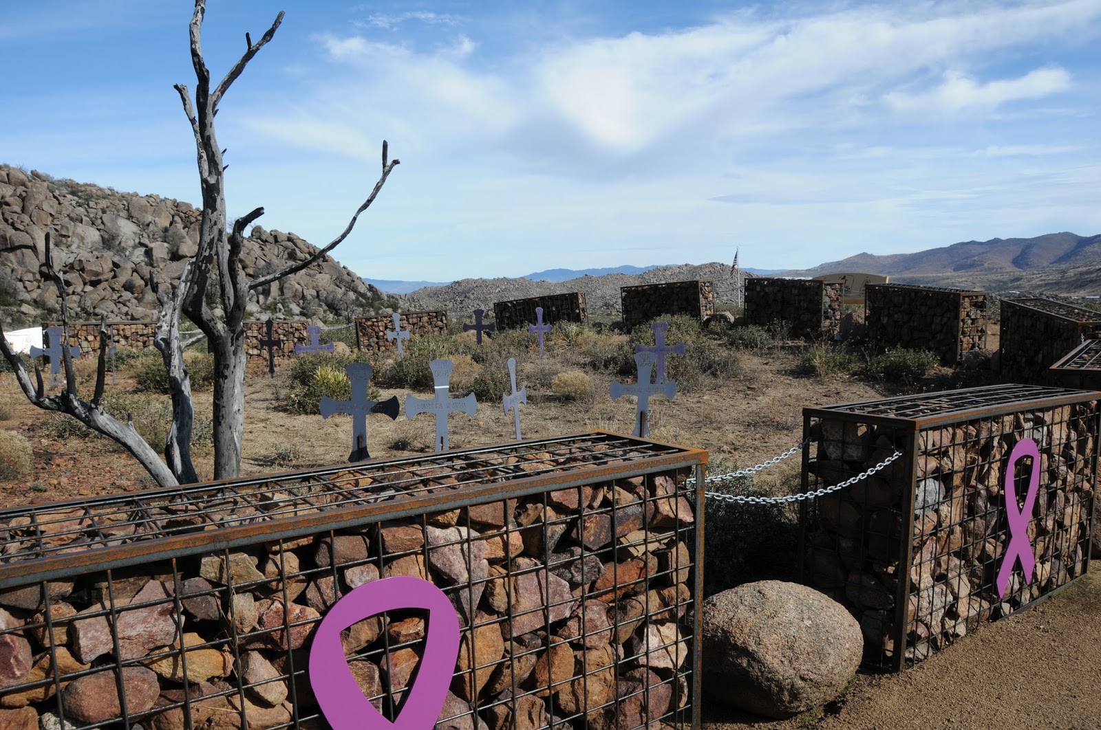
site. Four hundred feet below, a Stonehenge-like circle of 19 gabions surrounds
the place where the men perished. At the
trail’s high point, an observation deck marks the beginning of the Journey
Trail that traces the hotshots final trek. Here, I met a group of people
wearing t-shirts and hats emblazoned with various fire department logos. They
came from Phoenix, Prescott, Flagstaff, California and Canada in sort of a
pilgrimage of brotherhood. There’s a sign at the deck with color photos of the
19 and a summary of the fire’s progression. When viewed from just the right
angle, the portraits align with the fatality site below.
| Fatality Site |
“I’m not gonna cry.”
Decision time. Should I go down
the 0.75-mile Journey Trail to visit the final memorials? To further mess me
up, right at this juncture, a flock of ravens appeared on the air currents
above, their vocalizations morphing from “Caw, Caw” into “Go, Go”. A psychic in
Sedona once told me that the raven is my animal totem, so I went. The sensation was a maniacal elixir of exhilaration
and numbness. I didn’t know quite what to feel. Was this a taking sort of voyeurism
or a genuine giving of respect? It’s hard to discern when distracted by conflicting
moods egged on by astonishing beauty and utter disaster.
The fatality site sits at
the mouth of a yawning canyon a heartbreaking half-mile from a ranch. The ugliness
of the fire has mostly disintegrated and fresh sprouts are emerging from the
bases of resilient shrubs that were here, then gone and here again.
| Fatality Site |
At the east end of the
memorial circle, somebody left a scorched Granite Mountain Hotshots t-shirt.
That’s where I lost it. Heaving sobs for
people I don’t know in a place I had never been, I guess this trail was a
little bit about me after all. And it's about you, too. We live, we love, we hike, we win,
we lose and it all ends up in a big friggin’ circle--kind of like the one that rolled
out before me at the base of Yarnell Hill.
| The T-Shirt |
LENGTH: 7.2 miles roundtrip
RATING: moderate
ELEVATION: 4,318’ – 5,061’
GETTING THERE:
From Phoenix, take
Interstate 17 north to State Route 74 (Carefree Highway). Head 30 miles west
toward Wickenburg and turn right (north) on US 60. Continue on US 60 to the
traffic circle at the Hassayampa River bridge, veer left and go north on State Route
93 to State Route 89 (White Spar Highway). Follow SR 89 toward Yarnell, go left
at the split, head up the winding mountain road and turn left at the sign for
the park. Roads are 100% paved. There
are 13 parking spaces and temporary restrooms at the trailhead.
INFO & MAP:
Subscribe to:
Posts (Atom)