NEW ROUND OF FOREST CLOSURES ON THE COCONINO
Just when you thought it couldn't get more crazy, the government shutdown is now forcing closure of campgrounds and other sites on Coconino National Forest. Some of these sites would have normally closed for the year at the end of October anyway. But others, even those run by private companies, are being forced to close. Generally, undeveloped trailheads, hiking trails and forest access via number roads remain open. A full list is available here:
WHAT'S CLOSED AS OF 10-11-13:
http://azdailysun.com/news/local/govt-and-politics/shutdown-claims-last-of-campsites/article_9047c168-30a7-11e3-bb47-0019bb2963f4.html
INTERESTING FIRST-PERSON COMMENTARY FROM A BUSINESS OWNER WHO OPERATES SOME OF THESE CLOSED SITES:
http://www.coyoteblog.com/
Saturday, October 12, 2013
Friday, October 11, 2013
Flagstaff fall color update: Oct 11, 2013
LAMAR HAINES MEMORIAL WILDLIFE AREA
Flagstaff
| Veit's Cabin, Oct. 11, 2013 |
Aspen overload with a side of fresh snow is the big draw along
Flagstaff’s Snowbowl Road this week. Heart-shaped leaves on the willowy, white-barked canopies are showing a mixed pallet of
ready-to-burst lemons, full bloom golds and past-prime caramels, so now is the
perfect time for fall color hiking. Exploring the Lamar Haines Memorial
Wildlife Area (a.k.a. Veit Springs) involves a short trek
packed with interesting
ruins, pictographs and a wide, easy tread--which is why it buries the needle on
the kid-pleasing scale. Allow plenty of time to stroll among the collapsed remains of homesteader
Ludwig Veit’s 1890s cabin, an historical marker commemorating the work of
conservationist Lamar Haines, and a concrete well with pond for collecting spring
water along this aspen-rich, 160-acres of wet meadows and old growth forest.
| Fresh snow, Oct. 11, 2013 |
LENGTH: 1.6-mile loop
RATING: easy
ELEVATION: 8,600’ – 8,800’
GETTING THERE: From Flagstaff, go 7.5 miles north on US180
to milepost 223, turn right onto Snowbowl Road and drive 4.2 miles to the Lamar
Haines Memorial Wildlife Area trailhead on the right. Parking is very limited.
SITE ADMINISTERED BY: Arizona Game & Fish Department
MORE PHOTOS:
Wednesday, October 9, 2013
Take the Sedona Hike Challenge 2013-14
SEDONA HIKE CHALLENGE 2013-14
Need an excuse to take a hiking trip to Sedona? Yeah, let me twist your arm, already. Well, Red Rock Country's favorite trekker mecca --The Hike House--is once again sponsoring the Sedona Hike Challenge beginning November 15th and running through March 15, 2014. Participation is so easy. Just go online to sign up in your preferred category, hike 2 Sedona trails, upload photos documenting your journeys and you'll be entered into drawings for gift packages filled with excellent outdoor gear and goodies. What could be better than that? And while you're in town, stop by the store, you'll be thrilled with the inventory, services and the staff's knowledge about local trails.
(This is NOT a paid endorsement---I just think it's cool.)
SIGN UP:
http://shc.webpartnergroup.net
The Hike House:
http://thehikehouse.com
| Turkey Creek Trail |
Need an excuse to take a hiking trip to Sedona? Yeah, let me twist your arm, already. Well, Red Rock Country's favorite trekker mecca --The Hike House--is once again sponsoring the Sedona Hike Challenge beginning November 15th and running through March 15, 2014. Participation is so easy. Just go online to sign up in your preferred category, hike 2 Sedona trails, upload photos documenting your journeys and you'll be entered into drawings for gift packages filled with excellent outdoor gear and goodies. What could be better than that? And while you're in town, stop by the store, you'll be thrilled with the inventory, services and the staff's knowledge about local trails.
(This is NOT a paid endorsement---I just think it's cool.)
SIGN UP:
http://shc.webpartnergroup.net
The Hike House:
http://thehikehouse.com
Monday, October 7, 2013
Sedona's West Fork of Oak Creek is OPEN during government shutdown
YES YES YES---West Fork of Oak Creek/Call of the Canyon is
OPEN--umm....not anymore....
| West Fork of Oak Creek: Oct. 13, 2012 |
http://www.coyoteblog.com/
Yes indeed, Arizona hikers sure love fall foliage season. Thankfully, Sedona's premier autumn color trail is OPEN---even during the
government shutdown.
Trekkers come from all over the globe to see the high desert maples, oaks, willows and hop trees blaze in bittersweet scarlet and honey hues surrounded by soaring red rock walls. It's truely one of the top hikes to do in October. Maximum leaf intensity happens mid-October but color begins breaking around the 10th and lasts through the month. Also, don't forget that streamside sycamore-cottonwood color along Oak Creek peaks in late October thru early November. Trails to try for riparian fall foliage in Sedona are: Baldwin, Huckaby, Red Rock Crossing and anything in Red Rock State Park.
INFO: West Fork concessionaire: 928-203-2900
http://www.fs.usda.gov/recarea/coconino/recreation/ohv/recarea/?recid=55432&actid=50
Trekkers come from all over the globe to see the high desert maples, oaks, willows and hop trees blaze in bittersweet scarlet and honey hues surrounded by soaring red rock walls. It's truely one of the top hikes to do in October. Maximum leaf intensity happens mid-October but color begins breaking around the 10th and lasts through the month. Also, don't forget that streamside sycamore-cottonwood color along Oak Creek peaks in late October thru early November. Trails to try for riparian fall foliage in Sedona are: Baldwin, Huckaby, Red Rock Crossing and anything in Red Rock State Park.
INFO: West Fork concessionaire: 928-203-2900
http://www.fs.usda.gov/recarea/coconino/recreation/ohv/recarea/?recid=55432&actid=50
Sunday, October 6, 2013
FALL COLOR UPDATE: Mogollon Rim, October 5, 2013
U-BAR TRAIL
Pinchot Cabin to McClintock Draw
| Barbershop Canyon, Oct. 5, 2013 |
Anchoring the east end of the Mogollon Rim’s iconic Cabin
Loop system of trails, U-Bar #28 cuts an undulating path through rugged
canyons, meadows and coniferous woodlands. Although hiking the entire loop is a rigorous, multi-day
endeavor, day-trippers can sample the remote north end by hiking from Pinchot
Cabin to McClintock Draw. In October, brilliant fall foliage seems to melt out
of the edgy topography. Gambel oaks peppered throughout the area’s pines and
spruce glow like randomly-strung lights. Streamside boxelders and willows
shine at the bottom of Barbershop Canyon while seas of frost-tinged brackens colonize every sodden, humus
packed crack in the limestone terrain.
This sensory smorgasbord mitigates the pain of the trail's
constant dips, climbs and the challenge of following a primitive tree-blazed
route.
| Gambel oak, Oct. 5, 2013 |
HIKE DIRECTIONS:
From the trailhead, hike the old roads to Pinchot
Cabin. Here, a sign points to the
start of U-Bar trail heading up the ridge behind the cabin. The route is marked
by tree blazes—follow them and you’ll be fine. At the top of the ridge, pass a
gate and continue on the road to a “T” intersection with FR95B and FR139G. Go RIGHT here and follow the road to a stock tank off to the right.
Just beyond it, the road splits with the trail heading off between the
forks marked by a hiker sign and cairn. Now the trail is a distinct footpath.
Continue past a large rusted water tank on the left. About 150 feet beyond the
tank, turn RIGHT where the trail forks.
There’s a tree blaze with arrow here. At 2.3 miles, cross FR139 and begin steep descent into
Barbershop Canyon followed by a climb out to McClintock Ridge. At 3.0 miles, cross
FR145 and follow FR9616A into McClintock Draw. See "more photos" below for pictures of critical junctions.
LENGTH: 8 miles as described here including access
detour
RATING: moderate
ELEVATION: 7,000' - 7,620' (1500’ accumulated gain)
GETTING THERE:
From Payson, travel north on AZ87to just before
milepost 300 and turn right onto FR95.Go 6.5 miles on FR95 to a bridge over
East Clear Creek and veer right to stay on FR95. Continue 4.5 miles to
FR139A (a few yards past a sign for Houston Draw), turn left and go 0.2 mile to
the trailhead marked by a sign for Fred Haught Trail. NOTE: as of
September 2013, FR 95 is closed between FR139G and 139A. To get to the Fred
Haught trailhead, park at the roadblock and hike 0.5 mile on FR95. Roads are
good gravel/dirt with winding mountain grades—sedans okay.
INFO: Mogollon Rim Ranger District, Coconino National
Forest, 928-477-2255
MORE PHOTOS:
Saturday, October 5, 2013
Travel alert for FR 95 on the Mogollon Rim
FR95 CLOSED BETWEEN FR139G AND 139A
Hikers, if you are planning a route beginning at the Fred Haught trailhead--which is the northern access point for Cabin Loop trails U-Bar, Houston Brothers, Fred Haught and AZ Trail--be advised that construction has closed FR95 where Houston Draw bisects the road. Looks like a new culvert is being installed, and who knows how long that will take with the government shutdown. No worries, though, you can park at the blockade and hike 0.5 mile on FR95 to the trailhead. Also, access to Kinder Crossing off FR95 is NOT impacted by this closure. Seriously---do not attempt to drive thru---here's what you will encounter:
| Construction at Houston Draw |
| Houston Draw on FR95 |
Thursday, October 3, 2013
What's open in Arizona during government shutdown?
Many National Forest recreation sites operated by private companies remain OPEN during the government shutdown. These include:
SEDONA:
Crescent
Moon / Red Rock Crossing,
Grasshopper Point
,West Fork / Call of
the Canyon
,Manzanita,
Cave Springs,
Chavez Crossing
,Pine
Flats East and West
Oak Creek Visitor Center,
Clear Creek,
Beaver Creek
PAYSON:
Christopher
Creek
,East Verde,
Houston Mesa,
Ponderosa,
Sharp
Creek
,Tonto Creek
FLAGSTAFF:
Ashurst
Lake,
Bonito,
Dairy Springs,
Lake Mary Day Use Area,
Lakeview,
Locket Meadow,
O'Leary Group,
Pinegrove
NORTH
RIM GG:
Demotte
,Jacob
Lake
TUCSON:
Rose
Canyon Lake,
Spencer Canyon,
Showers Point Group,
Whitetail
Tuesday, October 1, 2013
AZ State Parks OPEN during government shutdown
ARIZONA STATE PARKS & NATIONAL FORESTS WILL BE OPEN DURING GOVERNMENT SHUT DOWN
UPDATE: 10-10-13: the government shut is now forcing closure of national forest sites operated by private businesses. Not sure why. Check this out for first-hand updates from an owner/operator of many of these sites:
READ UPDATES from the small business that operates this site:
http://www.coyoteblog.com/
Hikers,
Although our National Parks may temporarily shutter during the government shutdown, our ARIZONA STATE PARKS will be open for business. Access to National Forests is open, However, NF OFFICES and online camping reservation website, http://www.recreation.gov are closed. Hiking and dispersed camping are not impacted. Although I have not received any press releases regarding specific NF campground closures--it's probably a good idea to call ahead (oh, but the offices are closed) for status of fee-camping areas. Many of these are managed by volunteer site hosts or private concessionaires who may be keeping the gates open during the government shutdown. If you are looking for alternative places to camp, you can make reservations online:
http://azstateparks.com
WHAT'S OPEN IN ARIZONA:
http://news.morningstar.com/all/market-wired/MWR1055914/many-federal-recreation-areas-in-arizona-remain-open-during-the-government-shutdown.aspx
| Dead Horse Ranch State Park |
UPDATE: 10-10-13: the government shut is now forcing closure of national forest sites operated by private businesses. Not sure why. Check this out for first-hand updates from an owner/operator of many of these sites:
READ UPDATES from the small business that operates this site:
http://www.coyoteblog.com/
Hikers,
Although our National Parks may temporarily shutter during the government shutdown, our ARIZONA STATE PARKS will be open for business. Access to National Forests is open, However, NF OFFICES and online camping reservation website, http://www.recreation.gov are closed. Hiking and dispersed camping are not impacted. Although I have not received any press releases regarding specific NF campground closures--it's probably a good idea to call ahead (oh, but the offices are closed) for status of fee-camping areas. Many of these are managed by volunteer site hosts or private concessionaires who may be keeping the gates open during the government shutdown. If you are looking for alternative places to camp, you can make reservations online:
http://azstateparks.com
WHAT'S OPEN IN ARIZONA:
http://news.morningstar.com/all/market-wired/MWR1055914/many-federal-recreation-areas-in-arizona-remain-open-during-the-government-shutdown.aspx
Sunday, September 29, 2013
ABINEAU-BEAR JAW FALL FOLIAGE HIKE
ABINEAU-BEAR JAW LOOP
Flagstaff
| Abineau Canyon, Sept. 28, 2013 |
Coaxed by freezing night temperatures and the
season’s first light dusting of snow, the aspens on the north face of
Flagstaff’s San Francisco Peaks are turning to gold. On Saturday, Sep. 28th, the trees above 10,000’
were well on their way to peak color while those lower on the mountain were
just developing a faint, lemony tinge.
This means prime time for high elevation fall foliage hiking has arrived. Because of its cool, canyon bound location on the mountain, leaves saturate and drop early and quickly on the Abineau-Bear Jaw loop. So head out this week to enjoy this classic autumn trek.
LENGTH:
7.9-mile loop
RATING: difficult
ELEVATION:
8530' - 10,400'
| Waterline Road: Sept 28, 2013 |
GETTING THERE:
| Abineau Canyon, Sept. 28, 2013 |
From Flagstaff, travel north on US180 (Fort Valley Rd) to
milepost 235.2 and turn right onto FR 151 (Hart Prairie Road, north
access). Continue 1.6 miles on FR
151 and connect to FR 418. Drive
3.1 miles on FR418 to FR9123J
(signed for Abineau-Bear Jaw), turn right and go 0.6 mile to the
trailhead.
Dirt/cinder roads are rutted but passable by carefully
driven sedans. Access via FR418
from 89A now requires 4x4 due to washouts.
INFO: Flagstaff
Ranger District, Coconino National Forest, 928-526-0866
MORE PHOTOS:
Saturday, September 28, 2013
Flagstaff fall color Sept. 28, 2013: UPDATE
Wednesday, September 25, 2013
Bridge over riffled waters
SHOW LOW BLUFF
| Bridge over Show Low Creek |
Dedicated in June 2012, this loop route is the newest
addition to the White Mountains Trails System. Because of its convenient
location, short length and moderate tread, this trail is a popular choice for
family jaunts and leisurely strolls. A paved path debarking from the trailhead
leads to a rustic stone bridge spanning Show Low Creek. Here, horses can sometimes be seen
grazing in green pastures. Beyond the bridge, the trail enters a forest of oaks,
pines and high desert yuccas for a short climb among basalt boulders to the top
of the loop where a
sign points to the Woolford trailhead. It's a bit confusing
here---go right to complete the loop, or, for a longer hike, head toward
Woolford to get to the bluff’s high point for nice views from the juniper
grasslands above town.
LENGTH: 1.5 miles
RATING: easy-moderate
ELEVATION: 6350' - 6400'
GETTING THERE:
The SR260/US60 junction in Show Low, go 1 mile south on
SR260 (White Mountain Road) to near milepost 284 and turn left at the sign for Show Low Bluff trail. There's a second trailhead off Woolford
Road.
INFO:
MORE PHOTOS:
Sunday, September 22, 2013
Creek hike with a mountain summit
BLUE RIDGE TRAIL via BILLY CREEK CONNECTOR
Pinetop-Lakeside
| Billy Creek |
The cool, spring-fed waters of Billy and Thompson creeks
anchor this deeply wooded mountain circuit. Perfect for a late summer or autumn
trek, the route is located just off Pinetop-Lakeside’s main drag making for a
quick up-and-around day hike with lots of variety.
One of the beautiful things about the Blue Ridge Trail is
that it can be accessed via either of its two trailheads or by way of Ice Cave
Trail, Springs Trail or Billy Creek Connector. But, if creekside trekking is
what you're after, the later provides the best water exposure. Along its 0.75-mile, course, Billy
Creek Connector is augmented with footpaths leading to bramble-embellished
quiet spaces at the water's edge. Go right at the Blue Ridge Trail loop junction and hike
through 2 miles of fragrant wet meadows to the Springs Trail turn off and the
beginning of the 600-foot climb to the summit of Blue Ridge Mountain through
airy, oak-pine woodlands, red earth, volcanic boulders and marauding
cattle. Blue diamond markers and
location beacons help keep hikers on course where dirt fire roads muddle the
map. Occasionally, tree cover parts just enough to reveal White Mountain vista
views, however, do not expect the stereotypical treeless, wind-in-your-face,
summit-conquering experience---- there are just too many trees.. If you have the stamina, take a side
trip on the Ice Cave Trail, which leaves from the return leg of the loop. It's
roughly 2 miles one-way (near mile post 8) to the lava tube cave. Would be spelunkers be warned,
hiking/climbing into the cave is not allowed.
| Near the top of Blue Ridge Mtn |
| Billy Creek |
LENGTH: 9.9-mile loop
RATING:
moderate
ELEVATION:
6880' - 7656'
GETTING THERE:
Billy Creek trailhead:
In Pinetop-Lakeside, go south on AZ260 (White Mtn Blvd) to milepost
252 (just past Darbi's) turn left onto Pinecrest Rd. and continue 0.1 mile to
the trailhead. Parking is very limited and for passenger vehicles only---do not
block private drives.
INFO:
Billy Creek Connector:
Blue Ridge Trail:
Saturday, September 21, 2013
Fall Color Report: Sept. 21, 2013
MOGOLLON RIM: 9-21-2013
Spotted these aspens across from the Horse Trap trailhead near Willow Springs Lake today--AZ260 between milepost 284-285.
Friday, September 20, 2013
Celebrate National Public Lands Day
NATIONAL PUBLIC LANDS DAY 2013
Saturday, September 28
| Honanki Heritage site, Sedona |
Celebrate the 20th
anniversary of National Public Lands Day---the largest single day of
volunteer work in the nation-- by participating in one of the 28
events going on in Arizona. Choose from Verde River Days at Dead
Horse Ranch SP, trail maintenance, clean up at South Mountain Park
and the public release of California condors at Vermillion Cliffs. So
whether your prefer to get your hands dirty or simply take a stroll,
check out the NPLD website for a list of AZ events. Also, it's a
fee-free day at National Parks, State Parks and the Red Rock
Pass normally required for Sedona area venues (like Palatki and Honanki
Heritage sites) will also be waived.
Arizona State Parks
WHAT TO DO AT AZ STATE PARKS IN OCTOBER
Did
you know that during the Great Recession, volunteers came to the
rescue to save our state parks? All those wonderful trails and
campgrounds are open, clean and ready for your next outdoor
adventure. So how about showing some appreciation by visiting a park
this month. Don't know where to start? Just pick up the OCTOBER issue of PHOENIX magazine and check out my article (Great Escapes, pg 56) for recreational suggestions, special October events in the parks and
also how you can get involved. And, oh yeah, you can eat that 4000-calorie breakfast on the cover if you go hiking later.
ON
SALE NOW
Here’s
where you can find PHOENIX magazine:
Safeway, Fry’s Marketplace, Wal-Mart, Costco, Sam’s Club,
Sunflower Markets, Sprouts, Borders, Barnes & Noble, CVS,
Walgreens, Sky Harbor Airport, Albertson’s, Fresh & Easy,
Lowe’s, Home Depot, Target, Whole Foods, Basha’s, A.J.’s, La
Grande Orange, The Kitchen, Area hospital gift shops WEB
SITE: http://www.phoenixmag.com/ ORDER BY PHONE: 480-664-3960
Thursday, September 19, 2013
National Forest 2013 Fall Color Hotline is now active
2013 FOREST SERVICE FALL COLOR
HOTLINE IS NOW OPEN
| Barbershop Trail, (1st week in October) Mogollon Rim |
And, we're off! Fall color hiking season is now underway and the hotline is up and running. The first report for region 3 (southwest ) states that there is no color yet in Arizona. Coconino National Forest reports that peak color is expected to happen during the first 2 weeks of October. Keep in mind, that "peak" is just that---the hump. So, look for foliage in the higher elevations beginning in the last week of September.
| Wilson Meadow (1st week in October), Flagstaff |
Coconino National Forest
weekly updates:
USDA R3 weekly updates:
1-800-354-4595
Tuesday, September 17, 2013
Sinagua equinox event
V-Bar-V Heritage Site Fall Equinox Hike & Presentation
Ancient peoples of the Verde Valley were consumate
astronomers who left a treasure trove of solar calendars and other etchings in
the russet sandstone around Beaver Creek.
This Sunday, researcher and author Ken Zoll will be speaking on the
petroglyphs of V Bar V and hosting the autumnal equinox LIVE as it passes over one of the site's Sinagua sunwatchers. This is a rare opportunity to see both
earth science and archeological research in action. The hike is an easy 1 mile roundtrip.
WHEN: Sunday
Sept 22, 2013
TIME: 1 p.m.
FEE: $5 per vehicle or valid Red Rock of Federal Interagency
Pass
GETTING THERE:
Take I17 north to the Sedona exit 198, turn right and go 2.8
miles on FR618 to the site.
INFO:
Red Rock Ranger District, Coconino National Forest,
928-203-2900
http://www.redrockcountry.org/recreation/cultural/v-bar-v.shtml
Sunday, September 15, 2013
Equinox excursion with fall color
PRIEST DRAW & HOWARD DRAW
Flagstaff
As the annual autumn equinox (Sept 22) brings the promise of
cooler temperatures in the Valley, it also heralds in a brief season of hybrid summer-fall
hiking in Arizona's higher elevations.
During the final week of September, high country trees break
with whispers of a warm autumnal palette above meadows awash in a slurry of
hanger-on summer blooms and past-prime grasses. This glorious dichotomy of
balmy sun and biting breezes serves up perfect trekking with a side of
camera-ready photo opportunities.
An interesting area to explore this subdivision of hiking nirvana is Priest and Howard Draws. Although it's pretty
much an off-the-radar kind of place for hiking, the wildly contoured limestone walls of these side-by-side shallow canyons are major "draws" for the sport of
bouldering. Complementing the
surrounding vegetation, a bank of caves, roofs, tunnels and pocked-and-cracked
walls result in unmitigated visual overdose. Add to that the hordes of mat-packing climbers hanging
upside down and scaling the rock superfly style, and you've got a hike of
extraordinary interest. The draws delve through woods and fields for roughly 1.5 miles to a point where the
cliffs disappear. Here, footpaths
continue on sans the manic mix of geology, athleticism and natural elements on
a seasonal cusp.
| Late September color in Howard Draw |
LENGTH: 3 miles roundtrip
RATING: easy
ELEVATION: 6,900' - 6650'
GETTING THERE:
From Phoenix, travel north on I17 to Lake Mary Road exit
339, which is south of the I40 interchange just before entering Flagstaff. Turn right, and at the bottom of the
off ramp, turn right again.
Continue 5.4 miles south on Lake Mary Road (FR3) to Crimson Road---this
is on the right hand side of the road just past the Canyon Vista Campground
turnoff. Turn right on Crimson and
then make an immediate left onto CR 132.
Continue 3 miles on CR132 (which is good gravel) to a dirt road on the
right signed "Priest Draw parking area". This is FR238, a deeply rutted (watch that entry drop),
unmaintained road where a high-clearance is required. Follow FR238 0.3-mile to the parking corral.
AREA IS DAY USE ONLY.
MORE PHOTOS:
https://www.facebook.com/media/set/?set=a.3149979527160.102024.1795269672&type=1&l=0d98653800
Wednesday, September 11, 2013
Fall foliage 2013
GET READY FOR ARIZONA FALL COLOR 2013
Hikers, time to start dusting off the cool weather gear because we are just a couple of weeks away from the start of fall foliage season. With all the recent crazy weather in the high country, it's still too early to predict peak color days or quality of the season. However, based on my past experiences, some of the first trails to take on autumnal glow are Flagstaff's Inner Basin and Abineau Bear Jaw. The aspens usually begin changing there in mid-to-late September. Here in Arizona, the show goes on for a good 3 months, trickling down through the lower elevations painting Sedona and the Mogollon Rim during October and the deserts November-December.
The USDA Fall Color Hotline---which provides weekly updates--should be activated in the next few days . I'll also be posting weekly updates here.
USDA FALL COLOR HOTLINE: 1-800-354-4595, press 3 for AZ.
http://www.fs.fed.us/fallcolors/2013/
| Abineau-Bear Jaw trail: late Sept. |
Hikers, time to start dusting off the cool weather gear because we are just a couple of weeks away from the start of fall foliage season. With all the recent crazy weather in the high country, it's still too early to predict peak color days or quality of the season. However, based on my past experiences, some of the first trails to take on autumnal glow are Flagstaff's Inner Basin and Abineau Bear Jaw. The aspens usually begin changing there in mid-to-late September. Here in Arizona, the show goes on for a good 3 months, trickling down through the lower elevations painting Sedona and the Mogollon Rim during October and the deserts November-December.
The USDA Fall Color Hotline---which provides weekly updates--should be activated in the next few days . I'll also be posting weekly updates here.
USDA FALL COLOR HOTLINE: 1-800-354-4595, press 3 for AZ.
http://www.fs.fed.us/fallcolors/2013/
Saturday, September 7, 2013
The “Pluto” of Flagstaff’s volcanoes
A1 MOUNTAIN
Flagstaff
| Bill Williams Mtn as seen from the rim |
Way back in 1930, from a telescope perched on Flagstaff's
Observatory Mesa, Percival Lowell discovered the planet Pluto---er, the
"trans-Neptunian object formerly known as Pluto". Stripped of its solar system membership
in 2006, the plutiod suffers the same ignoble status as the volcano that built
the hill from which it was discovered. From space, the conical, volcanic form of A1 Mountain is
clearly visible. However, because more impressive mountains and a coniferous
cloak obscure the geological wonders of this 300,000-year-old cinder cone, it's
considered a minor character in the Flagstaff volcanic field. Although it's small and often abused by target shooters and
dirt bikes, the hill deserves more respect. A1 Mountain and its molten issue
have made significant impacts on the surrounding landscape, birthing many of west Flagstaff's gnarled lava formations including Observatory
Mesa. A closed forest road (unsigned 9218D) serves as the trail for this
hike. Unmitigated by switchbacks,
the route goes straight up the hill with the last 0.2-mile being quite steep
with tricky footing. At the crest
of this final haul hikers emerge on the lip of the volcano's inner crater, but,
due to its heavily forested condition, this is difficult to discern. The only
clues are swales of vivid green grasses and tiny pools of rainwater in a ring
of gigantic Ponderosa pines confined in a surround of vertical igneous walls.
Within a few yards of the lip, the road splits, looping up to the summit, down
into the crater's east face breach and back again. From the high points, breaks in tree cover reveal views of
Bill Williams Mountain, Wing Mountain and the western plains of Kaibab National
Forest. To the east, the white
dome of Lowell Observatory resting on the ejecta of this beautiful massif opens
nightly to survey the universe.
| inside the crater |
LENGTH: 2 miles roundtrip
RATING: moderate
ELEVATION: 7700' - 8302'
GETTING THERE:
From Flagstaff, go west on I40 to exit 190, A1 Mountain Road
(FR506). Follow FR506 for 2.6 miles to FR518B, veer left (set your odometer)
and continue 1.4 miles to a culvert marked by 3 light-colored boulders on the
left side of the road and reflector posts. The trail begins a few yards beyond at an unsigned road on
the left. There's
plentiful parking a few steps little farther up FR518B. A high-clearance
vehicle is required.
MORE PHOTOS:
Tuesday, September 3, 2013
Wildflower wetlands
SINCLAIR WASH & RIO DE FLAG
Flagstaff Urban Trail System
| Rio de Flag |
Last weekend in Flagstaff, the morning air had a telling,
damp crispness to it. Shorter days
and cooler temperatures mean the summer wildflower season is winding down. But,
in the moist corridor of Rio de Flag, high country flora will be blooming
through late September. Sinclair
Wash Trail, which begins at Fort Tuthill Park and ends at the Arizona Trail off Route 66, is
a major artery of the Flagstaff Urban Trail System (FUTS). Winding through a diverse mix of
terrain and connecting with 8 other trails, the floral sweet spot of this wide,
mostly flat trail is the wetland area near Sawmill County Park. A short but
steep descent from the playground drops hikers in the middle of Rio de Flag---a
waterway created as part of the town's water reclamation program. The mile-long
segment follows the stream through a limestone canyon festooned with oak
archways and climbing vines. Where the trail approaches the I40 underpass, a
cattail-choked marsh fosters a plethora of plant and animal life. Here, the late summer wildflower
checklist includes: globemallow, wild chrysanthemum, sunflowers, clovers, wild
geranium, Red-osier dogwood, coneflowers, aquatic buttercups, New Mexican vervain
and alfalfa.
| wetlands |
LENGTH: 5.7 miles one way. 2 miles roundtrip for the Rio de
Flag section only.
RATING: easy
ELEVATION: 6805'- 6988"
GETTING THERE:
Sawmill County Park (short hike):
In Flagstaff, go east on Butler Ave to Lone Tree, turn
right, continue to Sawmill Road on the left and follow the signs to the park.
Fort Tuthill County Park (long hike):
From I17 south of Flagstaff, take exit 337 for AZ89A and
"county fairgrounds". At the end of the off ramp, continue straight
into Ft. Tuthill Park and follow the signs to trailhead parking.
| Prairie coneflower |
INFO: City of Flagstaff
MORE PHOTOS:
Monday, August 26, 2013
Epic views from a White Mountains mesa
TIMBER MESA
Pinetop-Lakeside
Recently upgraded to incorporate an extra 1.5 miles of White
Mountain scenic vistas, this undulating hike loops through a mix of shaded
coniferous woodlands and sun drenched pinion-juniper scrub. Route finding was also improved with the addition of
location markers (T1-T29) placed every quarter-mile and blue diamond tree
blazes that eliminate confusion where fire roads intersect the trail #636. After a short climb (mitigated by long
switchbacks) epic views begin to emerge. The western edge of the mesa--
buttressed by volcanic boulders--overlooks Jacques Marsh wetlands and Scott
Reservoir, where, in late summer, acres of wildflowers transform the high
country prairies into a sort of Monet painting replete with muddled hues, reflective
waters and shocking splats of gold all brushed and blended in unbridled strokes
over a living canvas. This hilltop art galley goes on for roughly 2 miles
before the trail veers east, ducking in-and-out of damp ravines, deadwood
lizard habitats and spare high points with a start-to-finish cache of
alluring natural and human-made curiosities.
LENGTH: 7.9-mile loop (including 0.4 mile on access path)
RATING:
moderate
ELEVATION: 6,640' - 6,960'
FACILITIES: none
GETTING THERE:
From Phoenix, travel north on SR87 to the SR260 junction in
Payson. Head east (right) and
follow SR260 to milepost 350 and the stoplight at Porter Mountain Road (FR45)
in Pinetop-Lakeside. Turn left at
the light and go 2.2 miles (veer right at the 1.7-mile point to stay on FR45)
to the trailhead sign. Turn left
and continue 0.1 mile on a dirt road (watch that rut!) to the trailhead.
MAP:
INFO:
Lakeside Ranger District, Apache-Sitgreaves National Forest, 928-368-2100
MORE PHOTOS:
Sunday, August 18, 2013
POVERTY DRAW & KEHL CANYON
Mogollon Rim
| Typical trail condition |
Forest roads have always been open to hikers for easy
treks. Now that the forest service
has been closing less-used roads to motorized traffic to allow soils, plants
and wildlife habitats to recover, these eroding ruts have found second lives as
footpaths. Forest Road 147E is one
of those routes. Located on the
Mogollon Rim near Potato Lake, this former Jeep two-track provides easy access to
East Clear Creek and the upper portion of Kehl Canyon. Although it will be decades before
roads like this one are totally absorbed into the wilds,
| Moist & mossy |
For this adventure, there’s no officially numbered hiking
trail, however, the route is not too difficult to navigate. Here’s the plan:
From the parking area, begin hiking on FR147E. This dirt
road parallels Poverty Draw, which runs off to the left. Well equipped,
experienced hikers can drop into the draw and pick through a maze of brush
and pools for 1 mile to East Clear Creek, but the easy way is to walk on FR147E
to the 0.9-mile point where a barbed wire fence blocks the road. Do NOT pass
through the fence—instead, head left following the wire line to a primitive
entry in the barbed wire. Cross the fence (leaving it the way you found it) and
hike downhill on a rudimentary path to East Clear Creek. Cross the creek and
hike east (straight ahead) aiming for the washed out embankment. Head right (south) and follow the
decommissioned 4x4 road into Kehl Canyon. After roughly 1mile, the road makes a
sharp right turn up a bank. Here
is where you’ll leave the road and head left to stay in Kehl Canyon. If you thought the hike up to this
point was amazing---just wait, it gets even better. From this point on,
contorted sandstone escarpments and old growth coniferous forests close in on
the moist and lush canyon. Sturdy boots, long pants and hiking sticks are
required to get through the rock barriers, logs, brush, water-carved caves and
a Technicolor show of marsh-loving wildflowers. The canyon snakes four miles southward to Rim Road and Kehl
Springs campground. However, the
going gets challenging at the 2.6-mile point, where a quagmire of deadfall,
boulder-choked washes, and narrow passages will slow your pace and tax your
problem-solving skills.
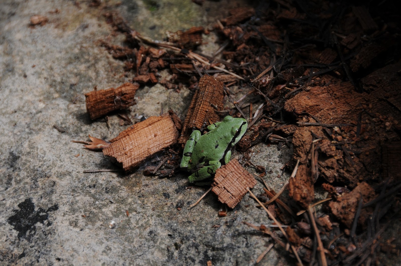
| Our state amphibian: Arizona tree frog |
LENGTHS:
FR147E to East Clear Creek: 1 mile.
Kehl Canyon turn off to Rim Road: 4 miles (difficult after
1.2 miles)
RATING:
moderate-difficult (route-finding, rough terrain)
ELEVATION: 6986' - 7420'
GETTING THERE:
From the State Route 87/260
intersection in Payson, continue north on SR87 to Forest Road 147 just north of milepost
287. Turn right and go 2.5 miles on FR147 to FR147E (past Poverty Spring)
on the left. Park here.
Subscribe to:
Posts (Atom)